Bridge Statistics for Mount Vernon, Alabama (AL)
Condition, Traffic, Stress, Structural Evaluation, Project Costs
- National Bridge Inventory (NBI) Statistics
- 11Number of bridges
- 135ft / 41.1mTotal length
- $15,786,000Total costs
- 58,418Total average daily traffic
- 6,875Total average daily truck traffic
- National Bridge Inventory (NBI) Registered Bridges for Mount Vernon
- No street view available for this location
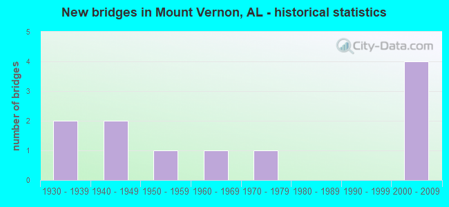
- New bridges - historical statistics
- 21930-1939
- 21940-1949
- 11950-1959
- 11960-1969
- 11970-1979
- 42000-2009

- Reconstructed bridges - Historical Statistics
- 21950-1959
- 11960-1969
- 01970-1979
- 11980-1989


- Bridge Condition - Deck
- 50.0%Good
- 50.0%Fair

- Bridge Condition - Superstructure
- 16.7%Very good
- 33.3%Good
- 16.7%Satisfactory
- 33.3%Fair

- Bridge Condition - Substructure
- 16.7%Very good
- 16.7%Good
- 33.3%Satisfactory
- 33.3%Fair

- Bridge Condition - Channel
- 25.0%Good
- 12.5%Satisfactory
- 62.5%Fair

- Bridge Condition - Culverts
- 25.0%Satisfactory
- 50.0%Fair
- 25.0%Poor
Find on map >> Show street view
Structure Number: 2689, Location: 0.38 MI N MILITARY RD (Lat: 31.090000, Lng: -88.011700), Route carried "on" structure: City street , Year Built: 1942, Status: Posted for load, Structure Length: 0.91m (2.99ft), Average Daily Traffic: 345 (year 2021), Truck Traffic: 1%, Average Future Daily Traffic: 514 (year 2041), Design Load: H 15, Features Intersected: DENNY BRANCH, Facility Carried by Structure: OLD HWY 43
Minimum Vertical Clearance: 30+ m (98+ ft), Kilometerpoint: 0.900, Lanes on structure: 2, Owner: City or Municipal Highway Agency, Approaching Roadway Width: 8.5m (27.9ft), Material/Design: Concrete, Design/Construction: Culvert, Number Of Spans In Main Unit: 5, Length of Maximum Span: 1.8m (5.9ft), Curb-To-Curb Width: 7.9m (25.9ft), Out-to-Out Width: 8.4m (27.6ft)
Condition: Channel: Fair, Culverts: Poor, Operating Rating: 11.3 metric tons, Method Used To Determine Operating Rating: Field evaluation and documented engineering judgment, Inventory Rating: 8.6 metric tons, Method Used To Determine Inventory Rating: Field evaluation and documented engineering judgment, Structural Evaluation: High priority of corrective action, Deck Geometry: Somewhat better than minimum adequacy, Waterway Adequacy: Equal to present desirable criteria, Approach Roadway Alignment: Equal to present minimum criteria, Bridge Posting: Required (Relationship of Operating Rating to Maximum Legal Load: > 39.9% below), Length Of Structure Improvement: 1.59m (5.22ft), Designated Inspection Frequency: Every 24 months, Other Special Inspection Frequency: Every 12 months, Inspection Date: September 2021, Other Special Inspection Date: September 2021, Bridge Improvement Cost: $238,000, Roadway Improvement Cost: $24,000, Total Project Cost: $262,000 ( Estimate for 2022)
Find on map >> Show street view
Structure Number: 269, Location: 1.3 MI N MILITARY ROAD (Lat: 31.103300, Lng: -88.010000), Route carried "on" structure: City street , Year Built: 1942, Status: Open, Structure Length: 1.28m (4.20ft), Average Daily Traffic: 345 (year 2021), Truck Traffic: 1%, Average Future Daily Traffic: 514 (year 2041), Design Load: H 15, Features Intersected: BEAVER DAM CREEK, Facility Carried by Structure: OLD HWY 43
Minimum Vertical Clearance: 30+ m (98+ ft), Kilometerpoint: 1.699, Lanes on structure: 2, Owner: City or Municipal Highway Agency, Approaching Roadway Width: 8.5m (27.9ft), Material/Design: Concrete, Design/Construction: Culvert, Number Of Spans In Main Unit: 4, Length of Maximum Span: 3.0m (9.8ft), Curb-To-Curb Width: 7.5m (24.6ft), Out-to-Out Width: 8.1m (26.6ft)
Condition: Channel: Satisfactory, Culverts: Satisfactory, Operating Rating: 47.1 metric tons, Method Used To Determine Operating Rating: Load Factor (LF), Inventory Rating: 28.3 metric tons, Method Used To Determine Inventory Rating: Load Factor (LF), Structural Evaluation: Equal to present minimum criteria, Deck Geometry: Somewhat better than minimum adequacy, Waterway Adequacy: Equal to present desirable criteria, Approach Roadway Alignment: Somewhat better than minimum adequacy, Length Of Structure Improvement: 1.95m (6.40ft), Designated Inspection Frequency: Every 24 months, Inspection Date: September 2021, Bridge Improvement Cost: $293,000, Roadway Improvement Cost: $29,000, Total Project Cost: $322,000 ( Estimate for 2022)
Find on map >> Show street view
Structure Number: 6755, Location: 1.7 MI N JCT CO RD 96 (Lat: 31.110050, Lng: -88.009619), Route carried "on" structure: US 43, Year Built: 1930, Year Reconstructed: 1957, Status: Open, Structure Length: 0.67m (2.20ft), Average Daily Traffic: 12,899 (year 2018), Truck Traffic: 14%, Average Future Daily Traffic: 19,349 (year 2038), Design Load: H 20, Features Intersected: LIL BEAVER DAM BRANCH
Minimum Vertical Clearance: 30+ m (98+ ft), Kilometerpoint: 43.489, Lanes on structure: 4, Base Highway Network: Yes, Owner: State Highway Agency, Approaching Roadway Width: 17.2m (56.4ft), Skew: 10 degrees, Material/Design: Concrete, Design/Construction: Culvert, Number Of Spans In Main Unit: 2, Length of Maximum Span: 3.0m (9.8ft)
Condition: Channel: Fair, Culverts: Fair, Operating Rating: 74.1 metric tons, Method Used To Determine Operating Rating: Load Factor (LF), Inventory Rating: 44.5 metric tons, Method Used To Determine Inventory Rating: Load Factor (LF), Structural Evaluation: Somewhat better than minimum adequacy, Waterway Adequacy: Somewhat better than minimum adequacy, Approach Roadway Alignment: Equal to present desirable criteria, Length Of Structure Improvement: 1.30m (4.27ft), Designated Inspection Frequency: Every 24 months, Inspection Date: August 2020, Bridge Improvement Cost: $916,000, Roadway Improvement Cost: $92,000, Total Project Cost: $1,008,000 ( Estimate for 2022)
Find on map >> Show street view
Structure Number: 6765, Location: 0.9 MI S CO RD 96 (Lat: 31.075467, Lng: -88.023425), Route carried "on" structure: US 43, Year Built: 1952, Year Reconstructed: 1960, Status: Open, Structure Length: 12.44m (40.81ft), Average Daily Traffic: 15,302 (year 2018), Truck Traffic: 13%, Average Future Daily Traffic: 22,953 (year 2038), Design Load: H 20, Features Intersected: CEDAR CREEK
Minimum Vertical Clearance: 30+ m (98+ ft), Kilometerpoint: 39.389, Lanes on structure: 4, Base Highway Network: Yes, Owner: State Highway Agency, Approaching Roadway Width: 18.2m (59.7ft), Skew: 20 degrees, Material/Design: Concrete, Design/Construction: Tee Beam, Number Of Spans In Main Unit: 12, Length of Maximum Span: 10.4m (34.1ft), Curb-To-Curb Width: 18.2m (59.7ft), Out-to-Out Width: 19.8m (65.0ft)
Condition: Deck: Fair, Superstructure: Fair, Substructure: Fair, Channel: Fair, Operating Rating: 37.9 metric tons, Method Used To Determine Operating Rating: Load Factor (LF), Inventory Rating: 22.8 metric tons, Method Used To Determine Inventory Rating: Load Factor (LF), Structural Evaluation: Somewhat better than minimum adequacy, Deck Geometry: Somewhat better than minimum adequacy, Waterway Adequacy: Equal to present minimum criteria, Approach Roadway Alignment: Better than present minimum criteria, Length Of Structure Improvement: 13.28m (43.57ft), Designated Inspection Frequency: Every 24 months, Underwater Inspection Frequency: Every 24 months, Inspection Date: August 2020, Underwater Inspection Date: May 2021, Bridge Improvement Cost: $5,917,000, Roadway Improvement Cost: $592,000, Total Project Cost: $6,509,000 ( Estimate for 2022), Deck Structure Type: Concrete Cast-file-Place, Wearing Surface/Protective System: Wearing Surface: Bituminous
Find on map >> Show street view
Structure Number: 752, Location: 2.5 MI N JCT CO RD 96 (Lat: 31.121369, Lng: -88.009825), Route carried "on" structure: US 43, Year Built: 1930, Year Reconstructed: 1962, Status: Open, Structure Length: 3.35m (10.99ft), Average Daily Traffic: 6,450 (year 2018), Truck Traffic: 14%, Average Future Daily Traffic: 9,675 (year 2038), Design Load: H 15, Features Intersected: BARROWS CREEK
Minimum Vertical Clearance: 30+ m (98+ ft), Kilometerpoint: 44.745, Lanes on structure: 2, Base Highway Network: Yes, Owner: State Highway Agency, Approaching Roadway Width: 8.5m (27.9ft), Skew: 10 degrees, Material/Design: Concrete, Design/Construction: Tee Beam, Number Of Spans In Main Unit: 3, Length of Maximum Span: 11.3m (37.1ft), Curb-To-Curb Width: 8.5m (27.9ft), Out-to-Out Width: 10.1m (33.1ft)
Condition: Deck: Fair, Superstructure: Fair, Substructure: Satisfactory, Channel: Fair, Operating Rating: 45.8 metric tons, Method Used To Determine Operating Rating: Load Factor (LF), Inventory Rating: 25.5 metric tons, Method Used To Determine Inventory Rating: Load Factor (LF), Structural Evaluation: Somewhat better than minimum adequacy, Deck Geometry: High priority of corrective action, Waterway Adequacy: Better than present minimum criteria, Approach Roadway Alignment: Equal to present desirable criteria, Length Of Structure Improvement: 4.24m (13.91ft), Designated Inspection Frequency: Every 24 months, Underwater Inspection Frequency: Every 24 months, Inspection Date: August 2020, Underwater Inspection Date: Febuary 2022, Bridge Improvement Cost: $959,000, Roadway Improvement Cost: $96,000, Total Project Cost: $1,055,000 ( Estimate for 2022), Deck Structure Type: Concrete Cast-file-Place, Wearing Surface/Protective System: Wearing Surface: Bituminous
Find on map >> Show street view
Structure Number: 7655, Location: 2.5 MI N JCT CO RD 96 (Lat: 31.121336, Lng: -88.009631), Route carried "on" structure: US 43, Year Built: 1962, Status: Open, Structure Length: 4.15m (13.62ft), Average Daily Traffic: 6,450 (year 2018), Truck Traffic: 14%, Average Future Daily Traffic: 9,675 (year 2038), Design Load: HS 20, Features Intersected: BARROWS CREEK
Minimum Vertical Clearance: 30+ m (98+ ft), Kilometerpoint: 44.745, Lanes on structure: 2, Base Highway Network: Yes, Owner: State Highway Agency, Approaching Roadway Width: 8.5m (27.9ft), Skew: 10 degrees, Material/Design: Concrete, Design/Construction: Tee Beam, Number Of Spans In Main Unit: 4, Length of Maximum Span: 10.4m (34.1ft), Curb-To-Curb Width: 8.5m (27.9ft), Out-to-Out Width: 10.1m (33.1ft)
Condition: Deck: Fair, Superstructure: Satisfactory, Substructure: Fair, Channel: Fair, Operating Rating: 48.3 metric tons, Method Used To Determine Operating Rating: Load Factor (LF), Inventory Rating: 28.9 metric tons, Method Used To Determine Inventory Rating: Load Factor (LF), Structural Evaluation: Somewhat better than minimum adequacy, Deck Geometry: High priority of corrective action, Waterway Adequacy: Equal to present minimum criteria, Approach Roadway Alignment: Better than present minimum criteria, Length Of Structure Improvement: 5.12m (16.80ft), Designated Inspection Frequency: Every 24 months, Underwater Inspection Frequency: Every 24 months, Inspection Date: August 2020, Underwater Inspection Date: Febuary 2022, Bridge Improvement Cost: $1,158,000, Roadway Improvement Cost: $116,000, Total Project Cost: $1,274,000 ( Estimate for 2022), Deck Structure Type: Concrete Cast-file-Place
Find on map >> Show street view
Structure Number: 11587, Location: 2.2 MI S COUNTY RD 96 (Lat: 31.073489, Lng: -88.047222), Route carried "on" structure: County highway , Year Built: 1976, Year Reconstructed: 1991, Status: Open, Structure Length: 0.94m (3.08ft), Average Daily Traffic: 24 (year 2020), Truck Traffic: 1%, Average Future Daily Traffic: 36 (year 2040), Design Load: H 20, Features Intersected: BULL BRANCH, Facility Carried by Structure: JOAN HARRIS RD
Minimum Vertical Clearance: 30+ m (98+ ft), Kilometerpoint: 2.200, Lanes on structure: 2, Owner: County Highway Agency, Approaching Roadway Width: 6.1m (20.0ft), Material/Design: Concrete, Design/Construction: Culvert, Number Of Spans In Main Unit: 4, Length of Maximum Span: 1.9m (6.2ft), Curb-To-Curb Width: 10.1m (33.1ft), Out-to-Out Width: 10.1m (33.1ft)
Condition: Channel: Good, Culverts: Fair, Operating Rating: 43.5 metric tons, Method Used To Determine Operating Rating: Field evaluation and documented engineering judgment, Inventory Rating: 32.7 metric tons, Method Used To Determine Inventory Rating: Field evaluation and documented engineering judgment, Structural Evaluation: Somewhat better than minimum adequacy, Deck Geometry: Superior to present desirable criteria, Waterway Adequacy: Equal to present minimum criteria, Approach Roadway Alignment: Better than present minimum criteria, Length Of Structure Improvement: 1.61m (5.28ft), Designated Inspection Frequency: Every 24 months, Inspection Date: November 2020, Bridge Improvement Cost: $279,000, Roadway Improvement Cost: $28,000, Total Project Cost: $307,000 ( Estimate for 2022)
Find on map >> Show street view
Structure Number: 19209, Location: 1.7 MI S COUNTY 96 (Lat: 31.080156, Lng: -88.047369), Route carried "on" structure: County highway , Year Built: 2003, Status: Open, Structure Length: 1.46m (4.79ft), Average Daily Traffic: 24 (year 2020), Truck Traffic: 1%, Average Future Daily Traffic: 36 (year 2040), Design Load: HS 20, Features Intersected: N. FORK OF CEDAR CREEK, Facility Carried by Structure: JOAN HARRIS ROAD
Minimum Vertical Clearance: 30+ m (98+ ft), Kilometerpoint: 1.699, Lanes on structure: 2, Owner: County Highway Agency, Approaching Roadway Width: 8.5m (27.9ft), Material/Design: Concrete, Design/Construction: Channel Beam, Number Of Spans In Main Unit: 2, Length of Maximum Span: 7.3m (24.0ft), Curb-To-Curb Width: 8.6m (28.2ft), Out-to-Out Width: 9.4m (30.8ft)
Condition: Deck: Good, Superstructure: Good, Substructure: Satisfactory, Channel: Good, Operating Rating: 67.9 metric tons, Method Used To Determine Operating Rating: Load Factor (LF), Inventory Rating: 40.7 metric tons, Method Used To Determine Inventory Rating: Load Factor (LF), Structural Evaluation: Equal to present minimum criteria, Deck Geometry: Better than present minimum criteria, Waterway Adequacy: Equal to present minimum criteria, Approach Roadway Alignment: Equal to present desirable criteria, Length Of Structure Improvement: 2.14m (7.02ft), Designated Inspection Frequency: Every 24 months, Inspection Date: November 2020, Bridge Improvement Cost: $441,000, Roadway Improvement Cost: $44,000, Total Project Cost: $485,000 ( Estimate for 2022), Deck Structure Type: Concrete Precast Panels
Find on map >> Show street view
Structure Number: 19989, Location: 1 MI. S. MOB/WASH CO LINE (Lat: 31.139919, Lng: -88.010392), Route carried "on" structure: Other road 43, Year Built: 2009, Status: Open, Structure Length: 8.82m (28.94ft), Average Daily Traffic: 1,548 (year 2018), Truck Traffic: 10%, Average Future Daily Traffic: 2,322 (year 2038), Design Load: HS 20, Features Intersected: US 43 NBL * SBL, Facility Carried by Structure: Steel Drive WBL
Minimum Vertical Clearance: 30+ m (98+ ft), Kilometerpoint: 46.354, Lanes on structure: 1, Lanes under structure: 5, Base Highway Network: Yes, Owner: State Highway Agency, Approaching Roadway Width: 10.9m (35.8ft), Material/Design: Prestressed concrete, Design/Construction: Stringer/Multi-beam, Number Of Spans In Main Unit: 4, Length of Maximum Span: 26.5m (86.9ft), Curb-To-Curb Width: 7.6m (24.9ft), Out-to-Out Width: 8.5m (27.9ft)
Condition: Deck: Good, Superstructure: Very good, Substructure: Very good, Operating Rating: 85.4 metric tons, Method Used To Determine Operating Rating: Load Factor (LF), Inventory Rating: 48.8 metric tons, Method Used To Determine Inventory Rating: Load Factor (LF), Structural Evaluation: Equal to present desirable criteria, Deck Geometry: Meets minimum limits, Underclear: Somewhat better than minimum adequacy, Approach Roadway Alignment: Equal to present desirable criteria, Length Of Structure Improvement: 9.80m (32.15ft), Designated Inspection Frequency: Every 24 months, Inspection Date: August 2020, Bridge Improvement Cost: $1,813,000, Roadway Improvement Cost: $181,000, Total Project Cost: $1,994,000 ( Estimate for 2022), Deck Structure Type: Concrete Cast-file-Place
Find on map >> Show street view
Structure Number: 19991, Location: .1 MI EAST OF US 43 (Lat: 31.139722, Lng: -88.008194), Route carried "on" structure: Other road 43, Year Built: 2009, Status: Open, Structure Length: 7.08m (23.23ft), Average Daily Traffic: 2,132 (year 2018), Truck Traffic: 10%, Average Future Daily Traffic: 3,198 (year 2038), Design Load: HS 20, Features Intersected: NORFOLK SOUTHERN RR, Facility Carried by Structure: Steel Drive WBL
Minimum Vertical Clearance: 30+ m (98+ ft), Kilometerpoint: 0.161, Lanes on structure: 2, Base Highway Network: Yes, Owner: State Highway Agency, Approaching Roadway Width: 10.6m (34.8ft), Material/Design: Prestressed concrete, Design/Construction: Stringer/Multi-beam, Number Of Spans In Main Unit: 3, Length of Maximum Span: 37.9m (124.3ft), Curb-To-Curb Width: 12.2m (40.0ft), Out-to-Out Width: 13.0m (42.7ft)
Condition: Deck: Good, Superstructure: Good, Substructure: Good, Operating Rating: 88.9 metric tons, Method Used To Determine Operating Rating: Load Factor (LF), Inventory Rating: 43.0 metric tons, Method Used To Determine Inventory Rating: Load Factor (LF), Structural Evaluation: Better than present minimum criteria, Deck Geometry: Better than present minimum criteria, Underclear: Superior to present desirable criteria, Approach Roadway Alignment: Equal to present desirable criteria, Length Of Structure Improvement: 8.11m (26.61ft), Designated Inspection Frequency: Every 24 months, Inspection Date: August 2020, Bridge Improvement Cost: $2,336,000, Roadway Improvement Cost: $234,000, Total Project Cost: $2,570,000 ( Estimate for 2022), Deck Structure Type: Concrete Cast-file-Place
Find on map >> Show street view
Structure Number: 19989, Location: 1 MI. S. MOB/WASH CO LINE (Lat: 31.139919, Lng: -88.010392), Route carried "under" structure: US 43, Year Built: 2009, Structure Length: 0. m, Average Daily Traffic: 12,899 (year 2018), Truck Traffic: 7%, Features Intersected: US 43 NBL * SBL, Facility Carried by Structure: Steel Drive WBL
Minimum Vertical Clearance: 6.00m (19.69ft), Kilometerpoint: 46.354, Lanes on structure: 1, Lanes under structure: 5, Material/Design: Prestressed concrete, Design/Construction: Stringer/Multi-beam, Length of Maximum Span: 26.5m (86.9ft)