Bridge Statistics for Mountain Brook, Alabama (AL)
Condition, Traffic, Stress, Structural Evaluation, Project Costs
- National Bridge Inventory (NBI) Statistics
- 20Number of bridges
- 144ft / 44.3mTotal length
- $21,332,000Total costs
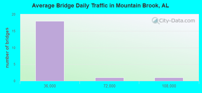
- 229,311Total average daily traffic
- 15,439Total average daily truck traffic
- National Bridge Inventory (NBI) Registered Bridges for Mountain Brook
- No street view available for this location
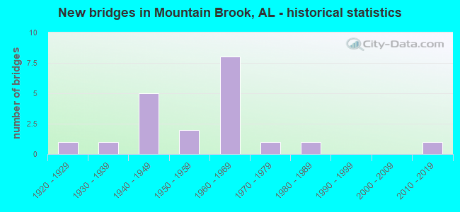
- New bridges - historical statistics
- 11920-1929
- 11930-1939
- 51940-1949
- 21950-1959
- 81960-1969
- 11970-1979
- 11980-1989
- 12010-2019
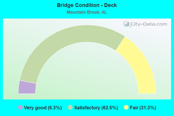
- Bridge Condition - Deck
- 6.3%Very good
- 62.5%Satisfactory
- 31.3%Fair
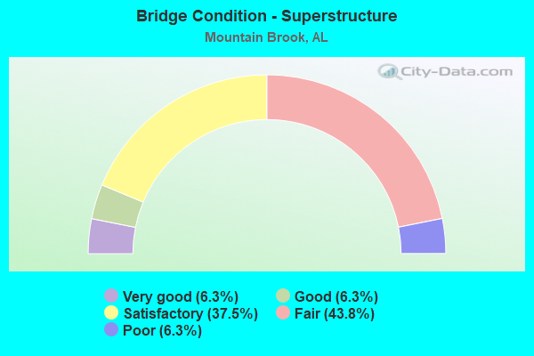
- Bridge Condition - Superstructure
- 6.3%Very good
- 6.3%Good
- 37.5%Satisfactory
- 43.8%Fair
- 6.3%Poor
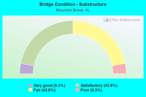
- Bridge Condition - Substructure
- 6.3%Very good
- 43.8%Satisfactory
- 43.8%Fair
- 6.3%Poor
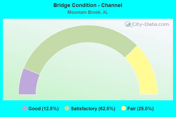
- Bridge Condition - Channel
- 12.5%Good
- 62.5%Satisfactory
- 25.0%Fair
Find on map >> Show street view
Structure Number: 285, Location: @ CO. RD. 227 (Lat: 33.093642, Lng: -86.794883), Route carried "on" structure: State highway 25, Year Built: 1925, Year Reconstructed: 1995, Status: Open, Structure Length: 0.67m (2.20ft), Average Daily Traffic: 6,290 (year 2020), Truck Traffic: 15%, Average Future Daily Traffic: 8,339 (year 2040), Features Intersected: BRANCH
Minimum Vertical Clearance: 30+ m (98+ ft), Kilometerpoint: 186.869, Lanes on structure: 2, Owner: State Highway Agency, Approaching Roadway Width: 7.3m (24.0ft), Material/Design: Concrete, Design/Construction: Culvert, Number Of Spans In Main Unit: 2, Length of Maximum Span: 3.0m (9.8ft)
Condition: Channel: Good, Culverts: Satisfactory, Operating Rating: 88.9 metric tons, Method Used To Determine Operating Rating: Load Factor (LF), Inventory Rating: 57.3 metric tons, Method Used To Determine Inventory Rating: Load Factor (LF), Structural Evaluation: Equal to present minimum criteria, Waterway Adequacy: Equal to present minimum criteria, Approach Roadway Alignment: Better than present minimum criteria, Length Of Structure Improvement: 1.30m (4.27ft), Designated Inspection Frequency: Every 24 months, Inspection Date: September 2020, Bridge Improvement Cost: $368,000, Roadway Improvement Cost: $37,000, Total Project Cost: $405,000 ( Estimate for 2022), Wearing Surface/Protective System: Wearing Surface: Bituminous
Find on map >> Show street view
Structure Number: 1364, Location: MOUNTAINBROOK GOLF COURSE (Lat: 33.500919, Lng: -86.734989), Route carried "on" structure: County highway 545, Year Built: 1935, Status: Open, Structure Length: 2.33m (7.64ft), Average Daily Traffic: 4,990 (year 2020), Truck Traffic: 5%, Average Future Daily Traffic: 6,975 (year 2040), Design Load: H 15, Features Intersected: SHADES CREEK, Facility Carried by Structure: OLD LEEDS ROAD
Minimum Vertical Clearance: 30+ m (98+ ft), Kilometerpoint: 0.010, Lanes on structure: 2, Owner: County Highway Agency, Approaching Roadway Width: 6.2m (20.3ft), Material/Design: Steel, Design/Construction: Culvert, Number Of Spans In Main Unit: 4, Length of Maximum Span: 5.5m (18.0ft), Curb-To-Curb Width: 7.9m (25.9ft), Out-to-Out Width: 8.6m (28.2ft)
Condition: Channel: Satisfactory, Culverts: Satisfactory, Operating Rating: 88.9 metric tons, Method Used To Determine Operating Rating: Load Factor (LF), Inventory Rating: 88.9 metric tons, Method Used To Determine Inventory Rating: Load Factor (LF), Structural Evaluation: Equal to present minimum criteria, Deck Geometry: High priority of corrective action, Waterway Adequacy: Equal to present minimum criteria, Approach Roadway Alignment: Equal to present minimum criteria, Length Of Structure Improvement: 3.17m (10.40ft), Designated Inspection Frequency: Every 24 months, Inspection Date: August 2020, Bridge Improvement Cost: $494,000, Roadway Improvement Cost: $49,000, Total Project Cost: $543,000 ( Estimate for 2022)
Find on map >> Show street view
Structure Number: 285, Location: MT BROOK PKWY * CAHABA RD (Lat: 33.476097, Lng: -86.763589), Route carried "on" structure: City street 77, Year Built: 1945, Status: Open, Structure Length: 0.79m (2.59ft), Average Daily Traffic: 9,025 (year 2016), Truck Traffic: 1%, Average Future Daily Traffic: 13,000 (year 2036), Design Load: HS 15, Features Intersected: WATKINS CREEK, Facility Carried by Structure: MT BROOK PKWY
Minimum Vertical Clearance: 30+ m (98+ ft), Kilometerpoint: 0.200, Lanes on structure: 2, Owner: City or Municipal Highway Agency, Approaching Roadway Width: 7.1m (23.3ft), Material/Design: Concrete, Design/Construction: Slab, Number Of Spans In Main Unit: 1, Length of Maximum Span: 7.0m (23.0ft), Curb or Sidewalk Widths: Left: 0.2m (0.7ft), Right: 2.0m (6.6ft), Curb-To-Curb Width: 7.1m (23.3ft), Out-to-Out Width: 10.6m (34.8ft)
Condition: Deck: Fair, Superstructure: Fair, Substructure: Fair, Channel: Fair, Operating Rating: 43.5 metric tons, Method Used To Determine Operating Rating: Field evaluation and documented engineering judgment, Inventory Rating: 32.7 metric tons, Method Used To Determine Inventory Rating: Field evaluation and documented engineering judgment, Structural Evaluation: Somewhat better than minimum adequacy, Deck Geometry: High priority of replacement, Waterway Adequacy: Equal to present minimum criteria, Approach Roadway Alignment: Equal to present minimum criteria, Length Of Structure Improvement: 1.45m (4.76ft), Designated Inspection Frequency: Every 24 months, Other Special Inspection Frequency: Every 12 months, Inspection Date: April 2020, Other Special Inspection Date: April 2021, Bridge Improvement Cost: $338,000, Roadway Improvement Cost: $34,000, Total Project Cost: $372,000 ( Estimate for 2022), Deck Structure Type: Concrete Cast-file-Place, Wearing Surface/Protective System: Wearing Surface: Bituminous
Find on map >> Show street view
Structure Number: 2851, Location: MT BROOK PKWY * OLDMILL (Lat: 33.480547, Lng: -86.759553), Route carried "on" structure: City street 79, Year Built: 1945, Status: Open, Structure Length: 1.46m (4.79ft), Average Daily Traffic: 8,115 (year 2016), Truck Traffic: 1%, Average Future Daily Traffic: 13,000 (year 2036), Design Load: HS 15, Features Intersected: SHADES CREEK, Facility Carried by Structure: MT BROOK PKWY
Minimum Vertical Clearance: 30+ m (98+ ft), Kilometerpoint: 0.999, Lanes on structure: 2, Owner: City or Municipal Highway Agency, Approaching Roadway Width: 7.0m (23.0ft), Material/Design: Concrete continuous, Design/Construction: Slab, Number Of Spans In Main Unit: 2, Length of Maximum Span: 6.9m (22.6ft), Curb or Sidewalk Widths: Left: 0.2m (0.7ft), Right: 2.1m (6.9ft), Curb-To-Curb Width: 7.1m (23.3ft), Out-to-Out Width: 10.5m (34.4ft)
Condition: Deck: Fair, Superstructure: Fair, Substructure: Fair, Channel: Fair, Operating Rating: 43.5 metric tons, Method Used To Determine Operating Rating: Field evaluation and documented engineering judgment, Inventory Rating: 32.7 metric tons, Method Used To Determine Inventory Rating: Field evaluation and documented engineering judgment, Structural Evaluation: Somewhat better than minimum adequacy, Deck Geometry: High priority of replacement, Waterway Adequacy: Equal to present minimum criteria, Approach Roadway Alignment: Better than present minimum criteria, Length Of Structure Improvement: 2.14m (7.02ft), Designated Inspection Frequency: Every 24 months, Other Special Inspection Frequency: Every 12 months, Inspection Date: April 2020, Other Special Inspection Date: April 2021, Bridge Improvement Cost: $499,000, Roadway Improvement Cost: $50,000, Total Project Cost: $549,000 ( Estimate for 2022), Deck Structure Type: Concrete Cast-file-Place, Wearing Surface/Protective System: Wearing Surface: Bituminous
Find on map >> Show street view
Structure Number: 2852, Location: MT BROOK PKWY * OLDMILL (Lat: 33.482131, Lng: -86.758186), Route carried "on" structure: City street 81, Year Built: 1945, Status: Open, Structure Length: 1.58m (5.18ft), Average Daily Traffic: 8,115 (year 2016), Truck Traffic: 1%, Average Future Daily Traffic: 13,000 (year 2036), Design Load: HS 15, Features Intersected: SHADES CREEK, Facility Carried by Structure: MT BROOK PKWY
Minimum Vertical Clearance: 30+ m (98+ ft), Kilometerpoint: 1.099, Lanes on structure: 2, Owner: City or Municipal Highway Agency, Approaching Roadway Width: 6.7m (22.0ft), Skew: 1 degrees, Material/Design: Concrete continuous, Design/Construction: Slab, Number Of Spans In Main Unit: 2, Length of Maximum Span: 7.0m (23.0ft), Curb or Sidewalk Widths: Left: 0.2m (0.7ft), Right: 2.0m (6.6ft), Curb-To-Curb Width: 6.6m (21.7ft), Out-to-Out Width: 10.0m (32.8ft)
Condition: Deck: Fair, Superstructure: Fair, Substructure: Fair, Channel: Fair, Operating Rating: 43.5 metric tons, Method Used To Determine Operating Rating: Field evaluation and documented engineering judgment, Inventory Rating: 32.7 metric tons, Method Used To Determine Inventory Rating: Field evaluation and documented engineering judgment, Structural Evaluation: Somewhat better than minimum adequacy, Deck Geometry: High priority of replacement, Waterway Adequacy: Equal to present minimum criteria, Approach Roadway Alignment: Better than present minimum criteria, Length Of Structure Improvement: 2.27m (7.45ft), Designated Inspection Frequency: Every 24 months, Inspection Date: April 2020, Bridge Improvement Cost: $498,000, Roadway Improvement Cost: $50,000, Total Project Cost: $548,000 ( Estimate for 2022), Deck Structure Type: Concrete Cast-file-Place, Wearing Surface/Protective System: Wearing Surface: Bituminous
Find on map >> Show street view
Structure Number: 2872, Location: Watkins Road (Lat: 33.479575, Lng: -86.768678), Route carried "on" structure: City street 300, Year Built: 1945, Status: Open, Structure Length: 0.73m (2.40ft), Average Daily Traffic: 1,008 (year 2014), Truck Traffic: 2%, Average Future Daily Traffic: 1,425 (year 2034), Design Load: H 15, Features Intersected: WATKINS CREEK, Facility Carried by Structure: WATKINS ROAD
Minimum Vertical Clearance: 30+ m (98+ ft), Kilometerpoint: 0.000, Lanes on structure: 2, Owner: City or Municipal Highway Agency, Approaching Roadway Width: 5.5m (18.0ft), Material/Design: Concrete, Design/Construction: Slab, Number Of Spans In Main Unit: 1, Length of Maximum Span: 6.1m (20.0ft), Curb or Sidewalk Widths: Left: 0.0m, Right: 1.7m (5.6ft), Curb-To-Curb Width: 5.2m (17.1ft), Out-to-Out Width: 8.9m (29.2ft)
Condition: Deck: Satisfactory, Superstructure: Fair, Substructure: Fair, Channel: Satisfactory, Operating Rating: 43.5 metric tons, Method Used To Determine Operating Rating: Field evaluation and documented engineering judgment, Inventory Rating: 32.7 metric tons, Method Used To Determine Inventory Rating: Field evaluation and documented engineering judgment, Structural Evaluation: Somewhat better than minimum adequacy, Deck Geometry: High priority of replacement, Waterway Adequacy: Equal to present minimum criteria, Approach Roadway Alignment: Somewhat better than minimum adequacy, Length Of Structure Improvement: 1.38m (4.53ft), Designated Inspection Frequency: Every 24 months, Inspection Date: April 2020, Bridge Improvement Cost: $274,000, Roadway Improvement Cost: $27,000, Total Project Cost: $301,000 ( Estimate for 2022), Deck Structure Type: Concrete Cast-file-Place, Wearing Surface/Protective System: Wearing Surface: Bituminous
Find on map >> Show street view
Structure Number: 2873, Location: Canterbury Road *Creek (Lat: 33.483536, Lng: -86.771869), Route carried "on" structure: City street 300, Year Built: 1945, Status: Posted for load, Structure Length: 0.70m (2.30ft), Average Daily Traffic: 2,015 (year 2016), Truck Traffic: 2%, Average Future Daily Traffic: 3,000 (year 2036), Design Load: H 15, Features Intersected: WATKINS CREEK, Facility Carried by Structure: CANTERBURY ROAD
Minimum Vertical Clearance: 30+ m (98+ ft), Kilometerpoint: 0.000, Lanes on structure: 2, Owner: City or Municipal Highway Agency, Approaching Roadway Width: 7.3m (24.0ft), Material/Design: Concrete, Design/Construction: Slab, Number Of Spans In Main Unit: 1, Length of Maximum Span: 6.1m (20.0ft), Curb or Sidewalk Widths: Left: 3.3m (10.8ft), Right: 3.3m (10.8ft), Curb-To-Curb Width: 8.0m (26.2ft), Out-to-Out Width: 15.7m (51.5ft)
Condition: Deck: Fair, Superstructure: Poor, Substructure: Poor, Channel: Satisfactory, Operating Rating: 18.1 metric tons, Method Used To Determine Operating Rating: Field evaluation and documented engineering judgment, Inventory Rating: 13.6 metric tons, Method Used To Determine Inventory Rating: Field evaluation and documented engineering judgment, Structural Evaluation: Meets minimum limits, Deck Geometry: High priority of corrective action, Waterway Adequacy: Equal to present minimum criteria, Approach Roadway Alignment: Equal to present minimum criteria, Bridge Posting: Required (Relationship of Operating Rating to Maximum Legal Load: > 39.9% below), Length Of Structure Improvement: 1.34m (4.40ft), Designated Inspection Frequency: Every 24 months, Other Special Inspection Frequency: Every 12 months, Inspection Date: April 2020, Other Special Inspection Date: April 2021, Bridge Improvement Cost: $468,000, Roadway Improvement Cost: $47,000, Total Project Cost: $515,000 ( Estimate for 2022), Deck Structure Type: Concrete Cast-file-Place, Wearing Surface/Protective System: Wearing Surface: Bituminous
Find on map >> Show street view
Structure Number: 3589, Location: 50' N OVERBROOK ROAD (Lat: 33.492497, Lng: -86.744753), Route carried "on" structure: County highway , Year Built: 1950, Status: Open, Structure Length: 1.50m (4.92ft), Average Daily Traffic: 2,460 (year 2018), Truck Traffic: 5%, Average Future Daily Traffic: 3,450 (year 2038), Features Intersected: SHADES CREEK, Facility Carried by Structure: BEECHWOOD ROAD
Minimum Vertical Clearance: 30+ m (98+ ft), Kilometerpoint: 0.010, Lanes on structure: 2, Owner: City or Municipal Highway Agency, Approaching Roadway Width: 6.3m (20.7ft), Material/Design: Concrete continuous, Design/Construction: Slab, Number Of Spans In Main Unit: 3, Length of Maximum Span: 5.3m (17.4ft), Curb or Sidewalk Widths: Left: 1.2m (3.9ft), Right: 0.0m, Curb-To-Curb Width: 6.9m (22.6ft), Out-to-Out Width: 9.2m (30.2ft)
Condition: Deck: Satisfactory, Superstructure: Fair, Substructure: Satisfactory, Channel: Satisfactory, Operating Rating: 43.5 metric tons, Method Used To Determine Operating Rating: Field evaluation and documented engineering judgment, Inventory Rating: 32.7 metric tons, Method Used To Determine Inventory Rating: Field evaluation and documented engineering judgment, Structural Evaluation: Somewhat better than minimum adequacy, Deck Geometry: High priority of replacement, Waterway Adequacy: Equal to present minimum criteria, Approach Roadway Alignment: Better than present minimum criteria, Length Of Structure Improvement: 2.18m (7.15ft), Designated Inspection Frequency: Every 24 months, Inspection Date: April 2020, Bridge Improvement Cost: $448,000, Roadway Improvement Cost: $45,000, Total Project Cost: $493,000 ( Estimate for 2022), Deck Structure Type: Concrete Cast-file-Place, Wearing Surface/Protective System: Wearing Surface: Bituminous
Find on map >> Show street view
Structure Number: 3828, Location: HEATHERMOOR DR * WATKIN C (Lat: 33.482322, Lng: -86.770767), Route carried "on" structure: City street 75, Year Built: 1950, Status: Open, Structure Length: 1.40m (4.59ft), Average Daily Traffic: 1,160 (year 2014), Truck Traffic: 1%, Average Future Daily Traffic: 1,525 (year 2034), Design Load: H 15, Features Intersected: WATKINS CREEK, Facility Carried by Structure: HEATHERMOOR RD
Minimum Vertical Clearance: 30+ m (98+ ft), Kilometerpoint: 0.100, Lanes on structure: 2, Owner: City or Municipal Highway Agency, Approaching Roadway Width: 6.8m (22.3ft), Skew: 1 degrees, Material/Design: Concrete, Design/Construction: Slab, Number Of Spans In Main Unit: 2, Length of Maximum Span: 6.4m (21.0ft), Curb or Sidewalk Widths: Left: 0.0m, Right: 1.7m (5.6ft), Curb-To-Curb Width: 10.0m (32.8ft), Out-to-Out Width: 13.8m (45.3ft)
Condition: Deck: Satisfactory, Superstructure: Satisfactory, Substructure: Fair, Channel: Satisfactory, Operating Rating: 43.5 metric tons, Method Used To Determine Operating Rating: Field evaluation and documented engineering judgment, Inventory Rating: 32.7 metric tons, Method Used To Determine Inventory Rating: Field evaluation and documented engineering judgment, Structural Evaluation: Somewhat better than minimum adequacy, Deck Geometry: Somewhat better than minimum adequacy, Waterway Adequacy: Equal to present minimum criteria, Approach Roadway Alignment: Better than present minimum criteria, Length Of Structure Improvement: 2.08m (6.82ft), Designated Inspection Frequency: Every 24 months, Inspection Date: April 2020, Bridge Improvement Cost: $641,000, Roadway Improvement Cost: $64,000, Total Project Cost: $705,000 ( Estimate for 2022), Deck Structure Type: Concrete Cast-file-Place, Wearing Surface/Protective System: Wearing Surface: Bituminous
Find on map >> Show street view
Structure Number: 7124, Location: Stone River Road *creek (Lat: 33.507072, Lng: -86.726667), Route carried "on" structure: City street 116, Year Built: 1960, Status: Open, Structure Length: 1.04m (3.41ft), Average Daily Traffic: 1,460 (year 2014), Truck Traffic: 1%, Average Future Daily Traffic: 2,040 (year 2034), Design Load: HS 15, Features Intersected: FURNACE BRANCH, Facility Carried by Structure: STONE RIVER ROAD
Minimum Vertical Clearance: 30+ m (98+ ft), Kilometerpoint: 0.599, Lanes on structure: 2, Owner: City or Municipal Highway Agency, Approaching Roadway Width: 9.0m (29.5ft), Material/Design: Concrete, Design/Construction: Channel Beam, Number Of Spans In Main Unit: 1, Length of Maximum Span: 10.4m (34.1ft), Curb or Sidewalk Widths: Left: 1.4m (4.6ft), Right: 0.3m (1.0ft), Curb-To-Curb Width: 9.0m (29.5ft), Out-to-Out Width: 10.6m (34.8ft)
Condition: Deck: Satisfactory, Superstructure: Satisfactory, Substructure: Satisfactory, Channel: Satisfactory, Operating Rating: 51.5 metric tons, Method Used To Determine Operating Rating: Load Factor (LF), Inventory Rating: 30.8 metric tons, Method Used To Determine Inventory Rating: Load Factor (LF), Structural Evaluation: Equal to present minimum criteria, Deck Geometry: Somewhat better than minimum adequacy, Waterway Adequacy: Equal to present minimum criteria, Approach Roadway Alignment: Equal to present minimum criteria, Length Of Structure Improvement: 1.71m (5.61ft), Designated Inspection Frequency: Every 24 months, Inspection Date: April 2020, Bridge Improvement Cost: $398,000, Roadway Improvement Cost: $40,000, Total Project Cost: $438,000 ( Estimate for 2022), Deck Structure Type: Concrete Precast Panels, Wearing Surface/Protective System: Wearing Surface: Bituminous
Find on map >> Show street view
Structure Number: 7129, Location: Wilderness Road *Creek (Lat: 33.510908, Lng: -86.722442), Route carried "on" structure: City street 118, Year Built: 1960, Status: Posted for load, Structure Length: 0.73m (2.40ft), Average Daily Traffic: 2,010 (year 2016), Truck Traffic: 1%, Average Future Daily Traffic: 3,000 (year 2036), Design Load: HS 15, Features Intersected: FURNACE BRANCH, Facility Carried by Structure: WILDERNESS ROAD
Minimum Vertical Clearance: 30+ m (98+ ft), Kilometerpoint: 0.299, Lanes on structure: 2, Owner: City or Municipal Highway Agency, Approaching Roadway Width: 9.1m (29.9ft), Material/Design: Concrete, Design/Construction: Channel Beam, Number Of Spans In Main Unit: 1, Length of Maximum Span: 6.5m (21.3ft), Curb or Sidewalk Widths: Left: 1.3m (4.3ft), Right: 0.2m (0.7ft), Curb-To-Curb Width: 9.1m (29.9ft), Out-to-Out Width: 10.6m (34.8ft)
Condition: Deck: Satisfactory, Superstructure: Satisfactory, Substructure: Fair, Channel: Satisfactory, Operating Rating: 39.6 metric tons, Method Used To Determine Operating Rating: Load Factor (LF), Inventory Rating: 23.4 metric tons, Method Used To Determine Inventory Rating: Load Factor (LF), Structural Evaluation: Somewhat better than minimum adequacy, Deck Geometry: Meets minimum limits, Waterway Adequacy: Equal to present minimum criteria, Approach Roadway Alignment: Equal to present minimum criteria, Bridge Posting: Required (Relationship of Operating Rating to Maximum Legal Load: 10.0 - 19.9% below), Length Of Structure Improvement: 1.38m (4.53ft), Designated Inspection Frequency: Every 24 months, Other Special Inspection Frequency: Every 12 months, Inspection Date: April 2020, Other Special Inspection Date: April 2021, Bridge Improvement Cost: $321,000, Roadway Improvement Cost: $32,000, Total Project Cost: $353,000 ( Estimate for 2022), Deck Structure Type: Concrete Precast Panels, Wearing Surface/Protective System: Wearing Surface: Bituminous
Find on map >> Show street view
Structure Number: 7402, Location: US 280 * PUMP HOUSE ROAD (Lat: 33.456164, Lng: -86.747253), Route carried "on" structure: City street , Year Built: 1961, Status: Open, Structure Length: 7.01m (23.00ft), Average Daily Traffic: 2,800 (year 2001), Truck Traffic: 3%, Average Future Daily Traffic: 3,800 (year 2040), Design Load: H 20, Features Intersected: US 280, Facility Carried by Structure: PUMP HOUSE RD
Minimum Vertical Clearance: 30+ m (98+ ft), Kilometerpoint: 0.100, Lanes on structure: 2, Lanes under structure: 6, Owner: State Highway Agency, Approaching Roadway Width: 9.8m (32.2ft), Skew: 2 degrees, Material/Design: Steel, Design/Construction: Stringer/Multi-beam, Number Of Spans In Main Unit: 2, Number Of Approach Spans: 3, Length of Maximum Span: 17.1m (56.1ft), Curb-To-Curb Width: 8.4m (27.6ft), Out-to-Out Width: 9.8m (32.2ft)
Condition: Deck: Satisfactory, Superstructure: Satisfactory, Substructure: Satisfactory, Operating Rating: 50.0 metric tons, Method Used To Determine Operating Rating: Load Factor (LF), Inventory Rating: 29.9 metric tons, Method Used To Determine Inventory Rating: Load Factor (LF), Structural Evaluation: Equal to present minimum criteria, Deck Geometry: High priority of corrective action, Underclear: High priority of corrective action, Approach Roadway Alignment: Equal to present minimum criteria, Length Of Structure Improvement: 8.04m (26.38ft), Designated Inspection Frequency: Every 24 months, Inspection Date: March 2020, Bridge Improvement Cost: $1,765,000, Roadway Improvement Cost: $177,000, Total Project Cost: $1,942,000 ( Estimate for 2022), Deck Structure Type: Concrete Cast-file-Place
Find on map >> Show street view
Structure Number: 8328, Location: US 280 * AL 149 (Lat: 33.473333, Lng: -86.766667), Route carried "on" structure: Ramp US 280, Year Built: 1964, Status: Open, Structure Length: 4.15m (13.62ft), Average Daily Traffic: 6,747 (year 2021), Truck Traffic: 6%, Average Future Daily Traffic: 8,874 (year 2041), Design Load: HS 20, Features Intersected: WATER * GAS MAINS
Minimum Vertical Clearance: 30+ m (98+ ft), Kilometerpoint: 2.173, Lanes on structure: 1, Base Highway Network: Yes, Owner: State Highway Agency, Approaching Roadway Width: 6.7m (22.0ft), Material/Design: Concrete, Design/Construction: Tee Beam, Number Of Spans In Main Unit: 4, Length of Maximum Span: 10.4m (34.1ft), Curb-To-Curb Width: 6.1m (20.0ft), Out-to-Out Width: 7.0m (23.0ft)
Condition: Deck: Satisfactory, Superstructure: Satisfactory, Substructure: Satisfactory, Operating Rating: 44.3 metric tons, Method Used To Determine Operating Rating: Load Factor (LF), Inventory Rating: 26.6 metric tons, Method Used To Determine Inventory Rating: Load Factor (LF), Structural Evaluation: Equal to present minimum criteria, Deck Geometry: Somewhat better than minimum adequacy, Approach Roadway Alignment: Meets minimum limits, Length Of Structure Improvement: 5.11m (16.77ft), Designated Inspection Frequency: Every 24 months, Inspection Date: August 2021, Bridge Improvement Cost: $806,000, Roadway Improvement Cost: $81,000, Total Project Cost: $887,000 ( Estimate for 2022), Deck Structure Type: Concrete Cast-file-Place
Find on map >> Show street view
Structure Number: 8329, Location: US 280 * AL 149 (Lat: 33.473333, Lng: -86.766667), Route carried "on" structure: Ramp US 280, Year Built: 1964, Status: Open, Structure Length: 4.39m (14.40ft), Average Daily Traffic: 6,747 (year 2021), Truck Traffic: 6%, Average Future Daily Traffic: 8,874 (year 2041), Design Load: HS 20, Features Intersected: WATER * GAS MAINS
Minimum Vertical Clearance: 30+ m (98+ ft), Kilometerpoint: 2.205, Lanes on structure: 1, Base Highway Network: Yes, Owner: State Highway Agency, Approaching Roadway Width: 6.1m (20.0ft), Material/Design: Concrete, Design/Construction: Tee Beam, Number Of Spans In Main Unit: 4, Length of Maximum Span: 11.0m (36.1ft), Curb-To-Curb Width: 6.1m (20.0ft), Out-to-Out Width: 7.0m (23.0ft)
Condition: Deck: Satisfactory, Superstructure: Satisfactory, Substructure: Satisfactory, Operating Rating: 52.3 metric tons, Method Used To Determine Operating Rating: Load Factor (LF), Inventory Rating: 31.3 metric tons, Method Used To Determine Inventory Rating: Load Factor (LF), Structural Evaluation: Equal to present minimum criteria, Deck Geometry: Somewhat better than minimum adequacy, Approach Roadway Alignment: Somewhat better than minimum adequacy, Length Of Structure Improvement: 5.37m (17.62ft), Designated Inspection Frequency: Every 24 months, Inspection Date: August 2021, Bridge Improvement Cost: $847,000, Roadway Improvement Cost: $85,000, Total Project Cost: $932,000 ( Estimate for 2022), Deck Structure Type: Concrete Cast-file-Place
Find on map >> Show street view
Structure Number: 833, Location: .1 MI. NO AL 149 (Lat: 33.472914, Lng: -86.765164), Route carried "on" structure: US 280, Year Built: 1964, Status: Open, Structure Length: 3.29m (10.79ft), Average Daily Traffic: 90,750 (year 2021), Truck Traffic: 8%, Average Future Daily Traffic: 119,369 (year 2041), Design Load: H 15, Features Intersected: SHADES CREEK
Minimum Vertical Clearance: 30+ m (98+ ft), Kilometerpoint: 2.285, Lanes on structure: 6, Base Highway Network: Yes, Owner: State Highway Agency, Approaching Roadway Width: 34.4m (112.9ft), Skew: 3 degrees, Material/Design: Concrete, Design/Construction: Culvert, Number Of Spans In Main Unit: 7, Length of Maximum Span: 4.0m (13.1ft)
Condition: Channel: Fair, Culverts: Satisfactory, Operating Rating: 88.9 metric tons, Method Used To Determine Operating Rating: Load Factor (LF), Inventory Rating: 88.9 metric tons, Method Used To Determine Inventory Rating: Load Factor (LF), Structural Evaluation: Equal to present minimum criteria, Waterway Adequacy: Equal to present desirable criteria, Approach Roadway Alignment: Equal to present desirable criteria, Length Of Structure Improvement: 4.17m (13.68ft), Designated Inspection Frequency: Every 24 months, Inspection Date: March 2021, Bridge Improvement Cost: $7,367,000, Roadway Improvement Cost: $737,000, Total Project Cost: $8,104,000 ( Estimate for 2022), Wearing Surface/Protective System: Wearing Surface: Bituminous
Find on map >> Show street view
Structure Number: 8636, Location: 500 FT S LAKESHORE DR (Lat: 33.474850, Lng: -86.763636), Route carried "on" structure: County highway , Year Built: 1965, Status: Posted for load, Structure Length: 2.53m (8.30ft), Average Daily Traffic: 3,526 (year 2021), Truck Traffic: 5%, Average Future Daily Traffic: 4,615 (year 2041), Features Intersected: SHADES CREEK, Facility Carried by Structure: CAHABA ROAD
Minimum Vertical Clearance: 30+ m (98+ ft), Kilometerpoint: 0.010, Lanes on structure: 2, Owner: County Highway Agency, Approaching Roadway Width: 7.0m (23.0ft), Material/Design: Concrete continuous, Design/Construction: Slab, Number Of Spans In Main Unit: 3, Length of Maximum Span: 9.1m (29.9ft), Curb-To-Curb Width: 6.7m (22.0ft), Out-to-Out Width: 7.5m (24.6ft)
Condition: Deck: Fair, Superstructure: Fair, Substructure: Satisfactory, Channel: Satisfactory, Operating Rating: 18.1 metric tons, Method Used To Determine Operating Rating: Field evaluation and documented engineering judgment, Inventory Rating: 13.6 metric tons, Method Used To Determine Inventory Rating: Field evaluation and documented engineering judgment, Structural Evaluation: Meets minimum limits, Deck Geometry: High priority of replacement, Waterway Adequacy: Equal to present minimum criteria, Approach Roadway Alignment: Equal to present minimum criteria, Bridge Posting: Required (Relationship of Operating Rating to Maximum Legal Load: > 39.9% below), Length Of Structure Improvement: 3.42m (11.22ft), Designated Inspection Frequency: Every 24 months, Other Special Inspection Frequency: Every 12 months, Inspection Date: June 2021, Other Special Inspection Date: June 2021, Bridge Improvement Cost: $563,000, Roadway Improvement Cost: $56,000, Total Project Cost: $619,000 ( Estimate for 2022), Deck Structure Type: Concrete Cast-file-Place, Wearing Surface/Protective System: Wearing Surface: Bituminous
Find on map >> Show street view
Structure Number: 10907, Location: RIVER RUN @ OVERTON (Lat: 33.481700, Lng: -86.712983), Route carried "on" structure: County highway , Year Built: 1973, Status: Open, Structure Length: 7.67m (25.16ft), Average Daily Traffic: 2,805 (year 2021), Truck Traffic: 2%, Average Future Daily Traffic: 3,900 (year 2041), Design Load: HS 20, Features Intersected: CAHABA RIVER, Facility Carried by Structure: RIVER RUN DRIVE
Minimum Vertical Clearance: 30+ m (98+ ft), Kilometerpoint: 0.010, Lanes on structure: 2, Owner: County Highway Agency, Approaching Roadway Width: 12.2m (40.0ft), Material/Design: Prestressed concrete, Design/Construction: Stringer/Multi-beam, Number Of Spans In Main Unit: 4, Length of Maximum Span: 18.9m (62.0ft), Curb or Sidewalk Widths: Left: 1.5m (4.9ft), Right: 0.3m (1.0ft), Curb-To-Curb Width: 10.5m (34.4ft), Out-to-Out Width: 12.3m (40.4ft)
Condition: Deck: Satisfactory, Superstructure: Good, Substructure: Satisfactory, Channel: Satisfactory, Operating Rating: 43.5 metric tons, Method Used To Determine Operating Rating: Field evaluation and documented engineering judgment, Inventory Rating: 32.7 metric tons, Method Used To Determine Inventory Rating: Field evaluation and documented engineering judgment, Structural Evaluation: Equal to present minimum criteria, Deck Geometry: Somewhat better than minimum adequacy, Waterway Adequacy: Better than present minimum criteria, Approach Roadway Alignment: Better than present minimum criteria, Length Of Structure Improvement: 8.69m (28.51ft), Designated Inspection Frequency: Every 24 months, Inspection Date: July 2021, Bridge Improvement Cost: $2,383,000, Roadway Improvement Cost: $238,000, Total Project Cost: $2,621,000 ( Estimate for 2022), Deck Structure Type: Concrete Cast-file-Place
Find on map >> Show street view
Structure Number: 12869, Location: OLD BRK TR @ LTLE SHADES (Lat: 33.451739, Lng: -86.751522), Route carried "on" structure: City street 114, Year Built: 1983, Status: Posted for load, Structure Length: 1.30m (4.27ft), Average Daily Traffic: 118 (year 2016), Truck Traffic: 1%, Average Future Daily Traffic: 200 (year 2036), Features Intersected: LITTLE SHADES CREEK, Facility Carried by Structure: OLD BROOK TRAIL
Minimum Vertical Clearance: 30+ m (98+ ft), Kilometerpoint: 0.200, Lanes on structure: 2, Owner: City or Municipal Highway Agency, Approaching Roadway Width: 5.5m (18.0ft), Skew: 2 degrees, Material/Design: Steel continuous, Design/Construction: Stringer/Multi-beam, Number Of Spans In Main Unit: 2, Length of Maximum Span: 5.9m (19.4ft), Curb or Sidewalk Widths: Left: 0.4m (1.3ft), Right: 0.4m (1.3ft), Curb-To-Curb Width: 6.4m (21.0ft), Out-to-Out Width: 7.2m (23.6ft)
Condition: Deck: Satisfactory, Superstructure: Fair, Substructure: Fair, Channel: Satisfactory, Operating Rating: 9.6 metric tons, Method Used To Determine Operating Rating: Load Factor (LF), Inventory Rating: 5.7 metric tons, Method Used To Determine Inventory Rating: Load Factor (LF), Structural Evaluation: High priority of replacement, Deck Geometry: Meets minimum limits, Waterway Adequacy: Equal to present minimum criteria, Approach Roadway Alignment: Somewhat better than minimum adequacy, Bridge Posting: Required (Relationship of Operating Rating to Maximum Legal Load: > 39.9% below), Length Of Structure Improvement: 1.97m (6.46ft), Designated Inspection Frequency: Every 24 months, Other Special Inspection Frequency: Every 12 months, Inspection Date: April 2020, Other Special Inspection Date: April 2021, Bridge Improvement Cost: $311,000, Roadway Improvement Cost: $31,000, Total Project Cost: $342,000 ( Estimate for 2022), Deck Structure Type: Concrete Cast-file-Place
Find on map >> Show street view
Structure Number: 20502, Location: Montevallo Park Road (Lat: 33.484547, Lng: -86.772461), Route carried "on" structure: City street 300, Year Built: 2011, Status: Open, Structure Length: 1.01m (3.31ft), Average Daily Traffic: 2,510 (year 2016), Truck Traffic: 2%, Average Future Daily Traffic: 3,400 (year 2036), Design Load: HS 20, Features Intersected: WATKINS CREEK, Facility Carried by Structure: MONTEVALLO ROAD
Minimum Vertical Clearance: 30+ m (98+ ft), Kilometerpoint: 0.000, Lanes on structure: 3, Owner: City or Municipal Highway Agency, Approaching Roadway Width: 9.8m (32.2ft), Material/Design: Concrete, Design/Construction: Channel Beam, Number Of Spans In Main Unit: 1, Length of Maximum Span: 9.1m (29.9ft), Curb or Sidewalk Widths: Left: 0.0m, Right: 2.4m (7.9ft), Curb-To-Curb Width: 9.8m (32.2ft), Out-to-Out Width: 15.8m (51.8ft)
Condition: Deck: Very good, Superstructure: Very good, Substructure: Very good, Channel: Good, Operating Rating: 44.8 metric tons, Method Used To Determine Operating Rating: Load Factor (LF), Inventory Rating: 24.4 metric tons, Method Used To Determine Inventory Rating: Load Factor (LF), Structural Evaluation: Equal to present minimum criteria, Deck Geometry: High priority of replacement, Waterway Adequacy: Equal to present desirable criteria, Approach Roadway Alignment: Equal to present desirable criteria, Length Of Structure Improvement: 1.69m (5.54ft), Designated Inspection Frequency: Every 24 months, Inspection Date: April 2020, Bridge Improvement Cost: $603,000, Roadway Improvement Cost: $60,000, Total Project Cost: $663,000 ( Estimate for 2022), Deck Structure Type: Concrete Precast Panels, Wearing Surface/Protective System: Wearing Surface: Bituminous
Find on map >> Show street view
Structure Number: 7402, Location: US 280 * PUMP HOUSE ROAD (Lat: 33.456164, Lng: -86.747253), Route carried "under" structure: US 280, Year Built: 1961, Structure Length: 0. m, Average Daily Traffic: 66,660 (year 2020), Truck Traffic: 8%, Features Intersected: US 280, Facility Carried by Structure: PUMP HOUSE RD
Minimum Vertical Clearance: 10.06m (33.01ft), Kilometerpoint: 5.200, Lanes on structure: 2, Lanes under structure: 6, Material/Design: Steel, Design/Construction: Stringer/Multi-beam, Length of Maximum Span: 17.1m (56.1ft)