Bridge Statistics for Mukwonago, Wisconsin (WI)
Condition, Traffic, Stress, Structural Evaluation, Project Costs
- National Bridge Inventory (NBI) Statistics
- 18Number of bridges
- 180ft / 55.3mTotal length
- $1,563,000Total costs
- 195,764Total average daily traffic
- 17,965Total average daily truck traffic
- National Bridge Inventory (NBI) Registered Bridges for Mukwonago
- No street view available for this location
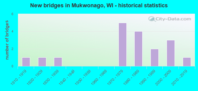
- New bridges - historical statistics
- 11910-1919
- 11920-1929
- 11930-1939
- 51970-1979
- 41980-1989
- 21990-1999
- 32000-2009
- 12010-2019


- Bridge Condition - Deck
- 7.7%Very good
- 38.5%Good
- 46.2%Satisfactory
- 7.7%Fair

- Bridge Condition - Superstructure
- 7.7%Very good
- 38.5%Good
- 38.5%Satisfactory
- 15.4%Fair

- Bridge Condition - Substructure
- 23.1%Very good
- 53.8%Good
- 15.4%Satisfactory
- 7.7%Fair

- Bridge Condition - Channel
- 90.0%Very good
- 10.0%Good

- Bridge Condition - Culverts
- 50.0%Good
- 50.0%Satisfactory
Find on map >> Show street view
Structure Number: B640086, Location: 1.7 MI N JCT CTH L (Lat: 42.840514, Lng: -88.335914), Route carried "on" structure: City street , Year Built: 1971, Status: Open, Structure Length: 11.88m (38.98ft), Average Daily Traffic: 1,200 (year 2019), Average Future Daily Traffic: 1,200 (year 2040), Design Load: H 20, Features Intersected: IH 43, Facility Carried by Structure: LRD STONE SCHOOL R
Minimum Vertical Clearance: 30+ m (98+ ft), Kilometerpoint: 0.000, Lanes on structure: 2, Lanes under structure: 4, Owner: State Highway Agency, Approaching Roadway Width: 10.4m (34.1ft), Skew: 4 degrees, Material/Design: Steel continuous, Design/Construction: Box Beam or Girders - Multiple, Number Of Spans In Main Unit: 2, Length of Maximum Span: 58.5m (191.9ft), Curb-To-Curb Width: 11.6m (38.1ft), Out-to-Out Width: 12.5m (41.0ft)
Condition: Deck: Satisfactory, Superstructure: Satisfactory, Substructure: Satisfactory, Operating Rating: 58.8 metric tons, Method Used To Determine Operating Rating: Load Factor (LF), Inventory Rating: 29.2 metric tons, Method Used To Determine Inventory Rating: Load Factor (LF), Structural Evaluation: Equal to present minimum criteria, Deck Geometry: Equal to present minimum criteria, Underclear: Somewhat better than minimum adequacy, Approach Roadway Alignment: Equal to present desirable criteria, Designated Inspection Frequency: Every 24 months, Other Special Inspection Frequency: Every 48 months, Inspection Date: March 2021, Other Special Inspection Date: March 2021, Wearing Surface/Protective System: Wearing Surface: Bituminous
Find on map >> Show street view
Structure Number: B670024, Location: 0.8M E JCT STH 83 (Lat: 42.859819, Lng: -88.314408), Route carried "on" structure: City street , Year Built: 2002, Status: Open, Structure Length: 4.06m (13.32ft), Average Daily Traffic: 6,700 (year 2018), Average Future Daily Traffic: 8,040 (year 2038), Design Load: HS 20, Features Intersected: MUKWONAGO RIVER, Facility Carried by Structure: LRD HOLZ PKWY
Minimum Vertical Clearance: 30+ m (98+ ft), Kilometerpoint: 0.000, Lanes on structure: 2, Owner: City or Municipal Highway Agency, Approaching Roadway Width: 12.2m (40.0ft), Material/Design: Prestressed concrete, Design/Construction: Stringer/Multi-beam, Number Of Spans In Main Unit: 1, Length of Maximum Span: 39.6m (129.9ft), Curb or Sidewalk Widths: Left: 2.9m (9.5ft), Right: 0.0m, Curb-To-Curb Width: 12.2m (40.0ft), Out-to-Out Width: 16.1m (52.8ft)
Condition: Deck: Good, Superstructure: Good, Substructure: Good, Channel: Very good, Operating Rating: 86.5 metric tons, Method Used To Determine Operating Rating: Load Factor (LF), Inventory Rating: 56.7 metric tons, Method Used To Determine Inventory Rating: Load Factor (LF), Structural Evaluation: Better than present minimum criteria, Deck Geometry: Somewhat better than minimum adequacy, Waterway Adequacy: Equal to present desirable criteria, Approach Roadway Alignment: Equal to present desirable criteria, Designated Inspection Frequency: Every 48 months, Inspection Date: July 2020, Deck Structure Type: Concrete Cast-file-Place, Wearing Surface/Protective System: Wearing Surface: Monolithic Concrete, Deck Protection: Epoxy Coated Reinforcing
Find on map >> Show street view
Structure Number: B670129, Location: 1.8 MI N JCT CTH L (Lat: 42.851475, Lng: -88.321331), Route carried "on" structure: State highway 83, Year Built: 1971, Status: Open, Structure Length: 7.71m (25.30ft), Average Daily Traffic: 23,450 (year 2018), Truck Traffic: 4%, Average Future Daily Traffic: 28,140 (year 2038), Design Load: HS 20, Features Intersected: IH 43
Minimum Vertical Clearance: 30+ m (98+ ft), Kilometerpoint: 0.000, Lanes on structure: 5, Lanes under structure: 4, Base Highway Network: Yes, Owner: State Highway Agency, Approaching Roadway Width: 25.0m (82.0ft), Skew: 20 degrees, Material/Design: Steel continuous, Design/Construction: Stringer/Multi-beam, Number Of Spans In Main Unit: 2, Length of Maximum Span: 37.9m (124.3ft), Curb or Sidewalk Widths: Left: 2.8m (9.2ft), Right: 0.0m, Curb-To-Curb Width: 25.0m (82.0ft), Out-to-Out Width: 31.3m (102.7ft)
Condition: Deck: Good, Superstructure: Satisfactory, Substructure: Fair, Operating Rating: 68.6 metric tons, Method Used To Determine Operating Rating: Load Factor (LF), Inventory Rating: 40.5 metric tons, Method Used To Determine Inventory Rating: Load Factor (LF), Structural Evaluation: Somewhat better than minimum adequacy, Deck Geometry: Superior to present desirable criteria, Underclear: Somewhat better than minimum adequacy, Approach Roadway Alignment: Equal to present desirable criteria, Designated Inspection Frequency: Every 24 months, Inspection Date: September 2021, Deck Structure Type: Concrete Cast-file-Place, Wearing Surface/Protective System: Wearing Surface: Monolithic Concrete
Find on map >> Show street view
Structure Number: B670147, Location: 0.5M E JCT CTH NN (Lat: 42.875486, Lng: -88.306697), Route carried "on" structure: County highway , Year Built: 1971, Status: Open, Structure Length: 4.78m (15.68ft), Average Daily Traffic: 9,500 (year 2018), Average Future Daily Traffic: 9,100 (year 2038), Design Load: HS 20, Features Intersected: FOX RIVER, Facility Carried by Structure: CTH ES
Minimum Vertical Clearance: 30+ m (98+ ft), Kilometerpoint: 0.000, Lanes on structure: 2, Base Highway Network: Yes, Owner: County Highway Agency, Approaching Roadway Width: 9.1m (29.9ft), Material/Design: Prestressed concrete continuous, Design/Construction: Stringer/Multi-beam, Number Of Spans In Main Unit: 2, Length of Maximum Span: 23.6m (77.4ft), Curb-To-Curb Width: 9.3m (30.5ft), Out-to-Out Width: 10.0m (32.8ft)
Condition: Deck: Very good, Superstructure: Good, Substructure: Good, Channel: Very good, Operating Rating: 47.4 metric tons, Method Used To Determine Operating Rating: Load Factor (LF), Inventory Rating: 27.5 metric tons, Method Used To Determine Inventory Rating: Load Factor (LF), Structural Evaluation: Equal to present minimum criteria, Deck Geometry: High priority of corrective action, Waterway Adequacy: Equal to present desirable criteria, Approach Roadway Alignment: Equal to present desirable criteria, Length Of Structure Improvement: 5.21m (17.09ft), Designated Inspection Frequency: Every 24 months, Underwater Inspection Frequency: Every 60 months, Inspection Date: November 2020, Underwater Inspection Date: November 2017, Bridge Improvement Cost: $834,000, Roadway Improvement Cost: $83,000, Total Project Cost: $1,252,000 ( Estimate for 2021), Deck Structure Type: Concrete Cast-file-Place, Wearing Surface/Protective System: Wearing Surface: Low Slump Concrete
Find on map >> Show street view
Structure Number: B670202, Location: 0.1M S JCT CTH LO (Lat: 42.860742, Lng: -88.365264), Route carried "on" structure: County highway , Year Built: 1981, Status: Open, Structure Length: 1.28m (4.20ft), Average Daily Traffic: 1,200 (year 2018), Average Future Daily Traffic: 1,440 (year 2038), Design Load: HS 20, Features Intersected: MUKWONAGO RIVER, Facility Carried by Structure: CTH I
Minimum Vertical Clearance: 30+ m (98+ ft), Kilometerpoint: 0.000, Lanes on structure: 2, Owner: County Highway Agency, Approaching Roadway Width: 9.1m (29.9ft), Skew: 1 degrees, Material/Design: Concrete, Design/Construction: Slab, Number Of Spans In Main Unit: 1, Length of Maximum Span: 12.2m (40.0ft), Curb-To-Curb Width: 8.5m (27.9ft), Out-to-Out Width: 9.1m (29.9ft)
Condition: Deck: Fair, Superstructure: Fair, Substructure: Good, Channel: Very good, Operating Rating: 62.1 metric tons, Method Used To Determine Operating Rating: Load Factor (LF), Inventory Rating: 35.6 metric tons, Method Used To Determine Inventory Rating: Load Factor (LF), Structural Evaluation: Somewhat better than minimum adequacy, Deck Geometry: Somewhat better than minimum adequacy, Waterway Adequacy: Equal to present desirable criteria, Approach Roadway Alignment: Equal to present desirable criteria, Designated Inspection Frequency: Every 24 months, Inspection Date: October 2020, Deck Structure Type: Concrete Cast-file-Place, Wearing Surface/Protective System: Wearing Surface: Monolithic Concrete
Find on map >> Show street view
Structure Number: B670204, Location: 0.4M S JCT STH 83 (Lat: 42.856058, Lng: -88.332203), Route carried "on" structure: County highway , Year Built: 1984, Status: Open, Structure Length: 1.15m (3.77ft), Average Daily Traffic: 5,700 (year 2018), Average Future Daily Traffic: 6,840 (year 2038), Design Load: HS 20, Features Intersected: MUKWONAGO RIVER, Facility Carried by Structure: CTH ES (MAIN ST)
Minimum Vertical Clearance: 30+ m (98+ ft), Kilometerpoint: 0.000, Lanes on structure: 2, Base Highway Network: Yes, Owner: County Highway Agency, Approaching Roadway Width: 13.4m (44.0ft), Skew: 1 degrees, Material/Design: Concrete, Design/Construction: Slab, Number Of Spans In Main Unit: 1, Length of Maximum Span: 11.0m (36.1ft), Curb or Sidewalk Widths: Left: 0.0m, Right: 2.0m (6.6ft), Curb-To-Curb Width: 13.4m (44.0ft), Out-to-Out Width: 15.4m (50.5ft)
Condition: Deck: Satisfactory, Superstructure: Satisfactory, Substructure: Good, Channel: Very good, Operating Rating: 52.3 metric tons, Method Used To Determine Operating Rating: Load Factor (LF), Inventory Rating: 30.8 metric tons, Method Used To Determine Inventory Rating: Load Factor (LF), Structural Evaluation: Equal to present minimum criteria, Deck Geometry: Equal to present minimum criteria, Waterway Adequacy: Equal to present desirable criteria, Approach Roadway Alignment: Equal to present desirable criteria, Designated Inspection Frequency: Every 24 months, Inspection Date: October 2020, Deck Structure Type: Concrete Cast-file-Place, Wearing Surface/Protective System: Wearing Surface: Monolithic Concrete, Deck Protection: Epoxy Coated Reinforcing
Find on map >> Show street view
Structure Number: B670216, Location: 0.5M N JCT IH 43 (Lat: 42.856817, Lng: -88.327303), Route carried "on" structure: State highway 83, Year Built: 1987, Status: Open, Structure Length: 1.89m (6.20ft), Average Daily Traffic: 18,200 (year 2018), Truck Traffic: 4%, Average Future Daily Traffic: 21,840 (year 2038), Design Load: HS 20, Features Intersected: MUKWONAGO RIVER
Minimum Vertical Clearance: 30+ m (98+ ft), Kilometerpoint: 0.000, Lanes on structure: 2, Base Highway Network: Yes, Owner: State Highway Agency, Approaching Roadway Width: 13.4m (44.0ft), Material/Design: Concrete continuous, Design/Construction: Slab, Number Of Spans In Main Unit: 2, Length of Maximum Span: 9.1m (29.9ft), Curb-To-Curb Width: 13.4m (44.0ft), Out-to-Out Width: 14.0m (45.9ft)
Condition: Deck: Satisfactory, Superstructure: Satisfactory, Substructure: Good, Channel: Very good, Operating Rating: 57.0 metric tons, Method Used To Determine Operating Rating: Load Factor (LF), Inventory Rating: 34.0 metric tons, Method Used To Determine Inventory Rating: Load Factor (LF), Structural Evaluation: Equal to present minimum criteria, Deck Geometry: Equal to present minimum criteria, Waterway Adequacy: Equal to present desirable criteria, Approach Roadway Alignment: Equal to present desirable criteria, Designated Inspection Frequency: Every 24 months, Inspection Date: September 2021, Deck Structure Type: Concrete Cast-file-Place, Wearing Surface/Protective System: Wearing Surface: Low Slump Concrete, Deck Protection: Epoxy Coated Reinforcing
Find on map >> Show street view
Structure Number: B67024, Location: 0.7 MI W JCT CTH J (Lat: 43.048111, Lng: -88.236583), Route carried "on" structure: County highway , Year Built: 1994, Status: Open, Structure Length: 9.40m (30.84ft), Average Daily Traffic: 3,300 (year 2018), Truck Traffic: 10%, Average Future Daily Traffic: 3,960 (year 2038), Design Load: HS 20, Features Intersected: IH 94, Facility Carried by Structure: CTH JJ
Minimum Vertical Clearance: 30+ m (98+ ft), Kilometerpoint: 0.000, Lanes on structure: 2, Lanes under structure: 8, Owner: State Highway Agency, Approaching Roadway Width: 13.4m (44.0ft), Skew: 3 degrees, Material/Design: Steel continuous, Design/Construction: Stringer/Multi-beam, Number Of Spans In Main Unit: 2, Length of Maximum Span: 46.0m (150.9ft), Curb-To-Curb Width: 13.4m (44.0ft), Out-to-Out Width: 14.3m (46.9ft)
Condition: Deck: Satisfactory, Superstructure: Good, Substructure: Good, Operating Rating: 73.0 metric tons, Method Used To Determine Operating Rating: Load Factor (LF), Inventory Rating: 43.7 metric tons, Method Used To Determine Inventory Rating: Load Factor (LF), Structural Evaluation: Better than present minimum criteria, Deck Geometry: Better than present minimum criteria, Underclear: Equal to present minimum criteria, Approach Roadway Alignment: Equal to present desirable criteria, Designated Inspection Frequency: Every 24 months, Inspection Date: May 2020, Deck Structure Type: Concrete Cast-file-Place, Wearing Surface/Protective System: Wearing Surface: Monolithic Concrete, Deck Protection: Epoxy Coated Reinforcing
Find on map >> Show street view
Structure Number: B670249, Location: 0.2M N JCT STH 83 (Lat: 42.865831, Lng: -88.329281), Route carried "on" structure: County highway , Year Built: 1995, Status: Open, Structure Length: 2.08m (6.82ft), Average Daily Traffic: 2,700 (year 2018), Average Future Daily Traffic: 3,240 (year 2038), Design Load: HS 20, Features Intersected: CN RR, Facility Carried by Structure: CTH ES (FOX ST)
Minimum Vertical Clearance: 30+ m (98+ ft), Kilometerpoint: 0.000, Lanes on structure: 2, Base Highway Network: Yes, Owner: County Highway Agency, Approaching Roadway Width: 11.0m (36.1ft), Skew: 5 degrees, Material/Design: Steel, Design/Construction: Stringer/Multi-beam, Number Of Spans In Main Unit: 1, Length of Maximum Span: 18.6m (61.0ft), Curb or Sidewalk Widths: Left: 2.0m (6.6ft), Right: 2.0m (6.6ft), Curb-To-Curb Width: 11.0m (36.1ft), Out-to-Out Width: 14.6m (47.9ft)
Condition: Deck: Good, Superstructure: Very good, Substructure: Very good, Operating Rating: 88.2 metric tons, Method Used To Determine Operating Rating: Load Factor (LF), Inventory Rating: 51.8 metric tons, Method Used To Determine Inventory Rating: Load Factor (LF), Structural Evaluation: Equal to present desirable criteria, Deck Geometry: Somewhat better than minimum adequacy, Underclear: Better than present minimum criteria, Approach Roadway Alignment: Equal to present minimum criteria, Designated Inspection Frequency: Every 48 months, Inspection Date: November 2020, Deck Structure Type: Concrete Cast-file-Place, Wearing Surface/Protective System: Wearing Surface: Monolithic Concrete, Deck Protection: Epoxy Coated Reinforcing
Find on map >> Show street view
Structure Number: B67028, Location: 3.7 MI S JCT CTH Q (Lat: 43.144550, Lng: -88.244144), Route carried "on" structure: State highway 164, Year Built: 2006, Status: Open, Structure Length: 1.19m (3.90ft), Average Daily Traffic: 8,500 (year 2018), Truck Traffic: 5%, Average Future Daily Traffic: 11,500 (year 2039), Design Load: HS 20, Features Intersected: SUSSEX CREEK
Minimum Vertical Clearance: 30+ m (98+ ft), Kilometerpoint: 0.000, Lanes on structure: 4, Base Highway Network: Yes, Owner: State Highway Agency, Approaching Roadway Width: 15.8m (51.8ft), Skew: 33 degrees, Material/Design: Concrete, Design/Construction: Slab, Number Of Spans In Main Unit: 1, Length of Maximum Span: 11.0m (36.1ft), Curb-To-Curb Width: 16.0m (52.5ft), Out-to-Out Width: 18.0m (59.1ft)
Condition: Deck: Good, Superstructure: Good, Substructure: Good, Channel: Very good, Operating Rating: 75.1 metric tons, Method Used To Determine Operating Rating: Load Factor (LF), Inventory Rating: 45.4 metric tons, Method Used To Determine Inventory Rating: Load Factor (LF), Structural Evaluation: Better than present minimum criteria, Deck Geometry: Meets minimum limits, Waterway Adequacy: Equal to present desirable criteria, Approach Roadway Alignment: Equal to present desirable criteria, Designated Inspection Frequency: Every 48 months, Inspection Date: October 2020, Deck Structure Type: Concrete Cast-file-Place, Wearing Surface/Protective System: Wearing Surface: Monolithic Concrete, Deck Protection: Epoxy Coated Reinforcing
Find on map >> Show street view
Structure Number: B670288, Location: 0.3M SE OF STH 83 (Lat: 42.849939, Lng: -88.315939), Route carried "on" structure: City street , Year Built: 2004, Status: Open, Structure Length: 0.73m (2.40ft), Average Daily Traffic: 530 (year 2019), Average Future Daily Traffic: 583 (year 2039), Design Load: HS 20, Features Intersected: TRIB. TO MUKWONAGO RIVER, Facility Carried by Structure: LRD MAPLE AVENUE
Minimum Vertical Clearance: 30+ m (98+ ft), Kilometerpoint: 0.000, Lanes on structure: 4, Owner: City or Municipal Highway Agency, Approaching Roadway Width: 16.2m (53.1ft), Skew: 1 degrees, Material/Design: Concrete, Design/Construction: Culvert, Number Of Spans In Main Unit: 1, Length of Maximum Span: 7.3m (24.0ft)
Condition: Channel: Very good, Culverts: Good, Operating Rating: 53.9 metric tons, Method Used To Determine Operating Rating: Field evaluation and documented engineering judgment, Inventory Rating: 32.4 metric tons, Method Used To Determine Inventory Rating: Field evaluation and documented engineering judgment, Structural Evaluation: Better than present minimum criteria, Waterway Adequacy: Equal to present desirable criteria, Approach Roadway Alignment: Equal to present desirable criteria, Designated Inspection Frequency: Every 48 months, Inspection Date: July 2020, Wearing Surface/Protective System: Wearing Surface: Bituminous
Find on map >> Show street view
Structure Number: B670334, Location: 1.0 MI S JCT STH 83 (Lat: 42.847850, Lng: -88.327228), Route carried "on" structure: Interstate 43, Year Built: 2014, Status: Open, Structure Length: 6.04m (19.82ft), Average Daily Traffic: 30,000 (year 2018), Truck Traffic: 18%, Average Future Daily Traffic: 36,000 (year 2038), Design Load: HL 93, Features Intersected: CN RR
Minimum Vertical Clearance: 30+ m (98+ ft), Kilometerpoint: 0.000, Lanes on structure: 2, Base Highway Network: Yes, Owner: State Highway Agency, Approaching Roadway Width: 13.4m (44.0ft), Skew: 4 degrees, Material/Design: Prestressed concrete, Design/Construction: Stringer/Multi-beam, Number Of Spans In Main Unit: 3, Length of Maximum Span: 28.3m (92.8ft), Curb-To-Curb Width: 13.4m (44.0ft), Out-to-Out Width: 14.2m (46.6ft)
Condition: Deck: Good, Superstructure: Good, Substructure: Very good, Operating Rating: 57.7 metric tons, Method Used To Determine Operating Rating: Load and Resistance Factor Rating (LRFR) rating reported by rating factor(RF) method using HL-93 loadings, Inventory Rating: 43.7 metric tons, Method Used To Determine Inventory Rating: Load and Resistance Factor Rating (LRFR) rating reported by rating factor(RF) method using HL-93 loadings, Structural Evaluation: Better than present minimum criteria, Deck Geometry: Superior to present desirable criteria, Underclear: Meets minimum limits, Approach Roadway Alignment: Equal to present desirable criteria, Designated Inspection Frequency: Every 48 months, Inspection Date: May 2018, Deck Structure Type: Concrete Cast-file-Place, Wearing Surface/Protective System: Wearing Surface: Epoxy Overlay, Deck Protection: Epoxy Coated Reinforcing
Find on map >> Show street view
Structure Number: B670952, Location: 0.1M N JCT CTH VV (Lat: 43.159486, Lng: -88.370772), Route carried "on" structure: State highway 83, Year Built: 1916, Status: Open, Structure Length: 1.22m (4.00ft), Average Daily Traffic: 5,600 (year 2018), Truck Traffic: 7%, Average Future Daily Traffic: 6,720 (year 2038), Design Load: H 15, Features Intersected: OCONOMOWOC RIVER
Minimum Vertical Clearance: 30+ m (98+ ft), Kilometerpoint: 0.000, Lanes on structure: 2, Owner: State Highway Agency, Approaching Roadway Width: 12.2m (40.0ft), Material/Design: Concrete, Design/Construction: Arch - Deck, Number Of Spans In Main Unit: 1, Length of Maximum Span: 10.7m (35.1ft), Curb-To-Curb Width: 13.7m (44.9ft), Out-to-Out Width: 14.8m (48.6ft)
Condition: Deck: Satisfactory, Superstructure: Fair, Substructure: Satisfactory, Channel: Very good, Operating Rating: 33.0 metric tons, Method Used To Determine Operating Rating: Load Factor (LF), Inventory Rating: 24.3 metric tons, Method Used To Determine Inventory Rating: Load Factor (LF), Structural Evaluation: Somewhat better than minimum adequacy, Deck Geometry: Superior to present desirable criteria, Waterway Adequacy: Equal to present desirable criteria, Approach Roadway Alignment: High priority of corrective action, Length Of Structure Improvement: 1.68m (5.51ft), Designated Inspection Frequency: Every 24 months, Inspection Date: April 2020, Bridge Improvement Cost: $207,000, Roadway Improvement Cost: $20,000, Total Project Cost: $311,000 ( Estimate for 2021), Deck Structure Type: Concrete Cast-file-Place, Wearing Surface/Protective System: Wearing Surface: Monolithic Concrete
Find on map >> Show street view
Structure Number: P640055, Location: 1.3M N JCT STH 20 (Lat: 42.795231, Lng: -88.321306), Route carried "on" structure: City street , Year Built: 1930, Status: Open, Structure Length: 0.94m (3.08ft), Average Daily Traffic: 94 (year 2019), Average Future Daily Traffic: 103 (year 2039), Design Load: H 15, Features Intersected: HONEY CREEK, Facility Carried by Structure: LRD BELL SCHOOL RD
Minimum Vertical Clearance: 30+ m (98+ ft), Kilometerpoint: 0.000, Lanes on structure: 2, Owner: Town or Township Highway Agency, Approaching Roadway Width: 7.9m (25.9ft), Material/Design: Steel, Design/Construction: Culvert, Number Of Spans In Main Unit: 2, Length of Maximum Span: 4.0m (13.1ft)
Condition: Channel: Good, Culverts: Satisfactory, Operating Rating: 53.9 metric tons, Method Used To Determine Operating Rating: Field evaluation and documented engineering judgment, Inventory Rating: 24.3 metric tons, Method Used To Determine Inventory Rating: Field evaluation and documented engineering judgment, Structural Evaluation: Equal to present minimum criteria, Waterway Adequacy: Equal to present desirable criteria, Approach Roadway Alignment: Equal to present desirable criteria, Designated Inspection Frequency: Every 24 months, Inspection Date: August 2020, Deck Structure Type: Corrugated Steel, Wearing Surface/Protective System: Wearing Surface: Bituminous
Find on map >> Show street view
Structure Number: P670923, Location: 0.4M S JCT CTH LO (Lat: 42.854389, Lng: -88.395033), Route carried "on" structure: City street , Year Built: 1983, Status: Open, Structure Length: 0.97m (3.18ft), Average Daily Traffic: 290 (year 2019), Average Future Daily Traffic: 319 (year 2039), Design Load: H 20, Features Intersected: MUKWONAGO RIVER, Facility Carried by Structure: LRD BEULAH RD
Minimum Vertical Clearance: 30+ m (98+ ft), Kilometerpoint: 0.000, Lanes on structure: 2, Owner: Town or Township Highway Agency, Approaching Roadway Width: 7.0m (23.0ft), Material/Design: Concrete, Design/Construction: Slab, Number Of Spans In Main Unit: 1, Length of Maximum Span: 9.1m (29.9ft), Curb-To-Curb Width: 8.5m (27.9ft), Out-to-Out Width: 9.1m (29.9ft)
Condition: Deck: Satisfactory, Superstructure: Satisfactory, Substructure: Very good, Channel: Very good, Operating Rating: 44.1 metric tons, Method Used To Determine Operating Rating: Load Factor (LF), Inventory Rating: 25.9 metric tons, Method Used To Determine Inventory Rating: Load Factor (LF), Structural Evaluation: Equal to present minimum criteria, Deck Geometry: Equal to present minimum criteria, Waterway Adequacy: Equal to present desirable criteria, Approach Roadway Alignment: Equal to present desirable criteria, Designated Inspection Frequency: Every 24 months, Inspection Date: July 2020, Deck Structure Type: Concrete Cast-file-Place, Wearing Surface/Protective System: Wearing Surface: Monolithic Concrete, Deck Protection: Epoxy Coated Reinforcing
Find on map >> Show street view
Structure Number: B640086, Location: 4.6M N JCT STH 20 TO E (Lat: 42.840514, Lng: -88.335914), Route carried "under" structure: Interstate 43, Year Built: 1971, Structure Length: 0. m, Average Daily Traffic: 30,000 (year 2018), Truck Traffic: 16%, Features Intersected: IH 43, Facility Carried by Structure: LRD STONE SCHOOL R
Minimum Vertical Clearance: 4.90m (16.08ft), Kilometerpoint: 0.000, Lanes on structure: 2, Lanes under structure: 4, Material/Design: Steel continuous, Design/Construction: Box Beam or Girders - Multiple, Length of Maximum Span: 58.5m (191.9ft)
Find on map >> Show street view
Structure Number: B670129, Location: 5.6M N JCT STH 20 TO E (Lat: 42.851475, Lng: -88.321331), Route carried "under" structure: Interstate 43, Year Built: 1971, Structure Length: 0. m, Average Daily Traffic: 30,000 (year 2018), Truck Traffic: 14%, Features Intersected: IH 43, Facility Carried by Structure: STH 83
Minimum Vertical Clearance: 4.90m (16.08ft), Kilometerpoint: 0.000, Lanes on structure: 5, Lanes under structure: 4, Material/Design: Steel continuous, Design/Construction: Stringer/Multi-beam, Length of Maximum Span: 37.9m (124.3ft)
Find on map >> Show street view
Structure Number: B670951, Location: 0.6M N JCT IH 43 TO N (Lat: 42.857231, Lng: -88.328411), Route carried "under" structure: State highway 83, Year Built: 1920, Structure Length: 0. m, Average Daily Traffic: 18,800 (year 2018), Truck Traffic: 4%, Features Intersected: STH 83-FRONT ST, Facility Carried by Structure: WCL RR
Minimum Vertical Clearance: 4.48m (14.70ft), Kilometerpoint: 0.000, Lanes under structure: 2, Material/Design: Wood or Timber, Design/Construction: Stringer/Multi-beam, Length of Maximum Span: 11.9m (39.0ft)