Bridge Statistics for Mulberry, Arkansas (AR)
Condition, Traffic, Stress, Structural Evaluation, Project Costs
- National Bridge Inventory (NBI) Statistics
- 42Number of bridges
- 469ft / 143mTotal length
- $2,333,000Total costs
- 300,130Total average daily traffic
- 9,310Total average daily truck traffic
- National Bridge Inventory (NBI) Registered Bridges for Mulberry
- No street view available for this location
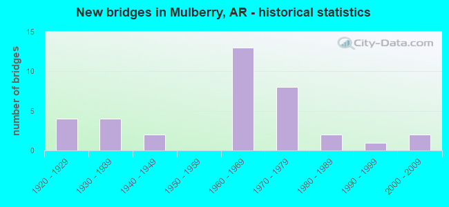
- New bridges - historical statistics
- 41920-1929
- 41930-1939
- 21940-1949
- 131960-1969
- 81970-1979
- 21980-1989
- 11990-1999
- 22000-2009

- Reconstructed bridges - Historical Statistics
- 11930-1939
- 01940-1949
- 41950-1959
- 01960-1969
- 11970-1979
- 01980-1989
- 11990-1999
- 12000-2009


- Bridge Condition - Deck
- 3.7%Very good
- 14.8%Good
- 59.3%Satisfactory
- 11.1%Fair
- 7.4%Poor
- 3.7%Serious

- Bridge Condition - Superstructure
- 7.4%Very good
- 18.5%Good
- 51.9%Satisfactory
- 11.1%Fair
- 7.4%Poor
- 3.7%Serious

- Bridge Condition - Substructure
- 14.8%Good
- 44.4%Satisfactory
- 29.6%Fair
- 7.4%Poor
- 3.7%Serious

- Bridge Condition - Channel
- 11.8%Very good
- 41.2%Good
- 38.2%Satisfactory
- 8.8%Fair

- Bridge Condition - Culverts
- 22.2%Good
- 55.6%Satisfactory
- 22.2%Fair
Find on map >> Show street view
Structure Number: 412, Location: 11.5 E JCT US 71 (Lat: 35.502439, Lng: -94.039581), Route carried "on" structure: US 64, Year Built: 1929, Year Reconstructed: 1961, Status: Open, Structure Length: 11.73m (38.48ft), Average Daily Traffic: 1,900 (year 2018), Truck Traffic: 1%, Average Future Daily Traffic: 2,975 (year 2027), Design Load: H 20, Features Intersected: Miller Creek-Crawford Co
Minimum Vertical Clearance: 30+ m (98+ ft), Kilometerpoint: 31.624, Lanes on structure: 2, Owner: State Highway Agency, Approaching Roadway Width: 12.2m (40.0ft), Material/Design: Concrete, Design/Construction: Tee Beam, Number Of Spans In Main Unit: 11, Length of Maximum Span: 10.7m (35.1ft), Curb or Sidewalk Widths: Left: 0.5m (1.6ft), Right: 0.5m (1.6ft), Curb-To-Curb Width: 8.5m (27.9ft), Out-to-Out Width: 9.6m (31.5ft)
Condition: Deck: Satisfactory, Superstructure: Satisfactory, Substructure: Fair, Channel: Good, Operating Rating: 46.3 metric tons, Method Used To Determine Operating Rating: Load Factor (LF), Inventory Rating: 27.2 metric tons, Method Used To Determine Inventory Rating: Load Factor (LF), Structural Evaluation: Somewhat better than minimum adequacy, Deck Geometry: Somewhat better than minimum adequacy, Waterway Adequacy: Equal to present desirable criteria, Approach Roadway Alignment: Equal to present desirable criteria, Designated Inspection Frequency: Every 24 months, Critical Feature Inspection Frequency: Every 24 months, Inspection Date: December 2021, Deck Structure Type: Concrete Cast-file-Place, Wearing Surface/Protective System: Wearing Surface: Bituminous
Find on map >> Show street view
Structure Number: 2285, Location: 6.95MI E JCT US 71 (Lat: 35.511186, Lng: -94.116261), Route carried "on" structure: US 64, Year Built: 1927, Year Reconstructed: 1962, Status: Open, Structure Length: 0.94m (3.08ft), Average Daily Traffic: 3,042 (year 2018), Truck Traffic: 5%, Average Future Daily Traffic: 3,492 (year 2028), Design Load: H 15, Features Intersected: Lee Br. - Crawford Co.
Minimum Vertical Clearance: 30+ m (98+ ft), Kilometerpoint: 24.172, Lanes on structure: 2, Owner: State Highway Agency, Approaching Roadway Width: 11.6m (38.1ft), Skew: 3 degrees, Material/Design: Steel, Design/Construction: Stringer/Multi-beam, Number Of Spans In Main Unit: 1, Length of Maximum Span: 8.8m (28.9ft), Curb or Sidewalk Widths: Left: 0.5m (1.6ft), Right: 0.5m (1.6ft), Curb-To-Curb Width: 8.5m (27.9ft), Out-to-Out Width: 10.3m (33.8ft)
Condition: Deck: Satisfactory, Superstructure: Satisfactory, Substructure: Satisfactory, Channel: Good, Operating Rating: 54.4 metric tons, Method Used To Determine Operating Rating: Load Factor (LF), Inventory Rating: 32.7 metric tons, Method Used To Determine Inventory Rating: Load Factor (LF), Structural Evaluation: Equal to present minimum criteria, Deck Geometry: Meets minimum limits, Waterway Adequacy: Better than present minimum criteria, Approach Roadway Alignment: Equal to present desirable criteria, Designated Inspection Frequency: Every 24 months, Critical Feature Inspection Frequency: Every 24 months, Inspection Date: August 2021, Deck Structure Type: Concrete Cast-file-Place, Wearing Surface/Protective System: Wearing Surface: Bituminous
Find on map >> Show street view
Structure Number: 2286, Location: 7.5MI E JCT US71 (Lat: 35.510892, Lng: -94.103692), Route carried "on" structure: US 64, Year Built: 1927, Year Reconstructed: 1962, Status: Open, Structure Length: 0.70m (2.30ft), Average Daily Traffic: 3,042 (year 2018), Truck Traffic: 4%, Average Future Daily Traffic: 4,527 (year 2028), Design Load: H 15, Features Intersected: Alexander Br.-Craw. Co.
Minimum Vertical Clearance: 30+ m (98+ ft), Kilometerpoint: 25.299, Lanes on structure: 2, Owner: State Highway Agency, Approaching Roadway Width: 12.2m (40.0ft), Material/Design: Steel, Design/Construction: Stringer/Multi-beam, Number Of Spans In Main Unit: 1, Length of Maximum Span: 6.7m (22.0ft), Curb or Sidewalk Widths: Left: 0.5m (1.6ft), Right: 0.5m (1.6ft), Curb-To-Curb Width: 8.5m (27.9ft), Out-to-Out Width: 10.3m (33.8ft)
Condition: Deck: Satisfactory, Superstructure: Satisfactory, Substructure: Satisfactory, Channel: Good, Operating Rating: 39.0 metric tons, Method Used To Determine Operating Rating: Load Factor (LF), Inventory Rating: 23.6 metric tons, Method Used To Determine Inventory Rating: Load Factor (LF), Structural Evaluation: Equal to present minimum criteria, Deck Geometry: Meets minimum limits, Waterway Adequacy: Equal to present desirable criteria, Approach Roadway Alignment: Equal to present desirable criteria, Designated Inspection Frequency: Every 24 months, Critical Feature Inspection Frequency: Every 24 months, Inspection Date: August 2021, Deck Structure Type: Concrete Cast-file-Place, Wearing Surface/Protective System: Wearing Surface: Bituminous
Find on map >> Show street view
Structure Number: 2287, Location: 7.8 E JCT US 71 (Lat: 35.510692, Lng: -94.093806), Route carried "on" structure: US 64, Year Built: 1927, Year Reconstructed: 1962, Status: Open, Structure Length: 1.04m (3.41ft), Average Daily Traffic: 3,042 (year 2018), Truck Traffic: 4%, Average Future Daily Traffic: 4,527 (year 2028), Design Load: H 15, Features Intersected: Little Lee Br.-Craw. Co.
Minimum Vertical Clearance: 30+ m (98+ ft), Kilometerpoint: 26.184, Lanes on structure: 2, Owner: State Highway Agency, Approaching Roadway Width: 12.2m (40.0ft), Skew: 4 degrees, Material/Design: Steel, Design/Construction: Stringer/Multi-beam, Number Of Spans In Main Unit: 1, Length of Maximum Span: 10.1m (33.1ft), Curb or Sidewalk Widths: Left: 0.5m (1.6ft), Right: 0.5m (1.6ft), Curb-To-Curb Width: 8.4m (27.6ft), Out-to-Out Width: 10.3m (33.8ft)
Condition: Deck: Satisfactory, Superstructure: Satisfactory, Substructure: Satisfactory, Channel: Satisfactory, Operating Rating: 46.3 metric tons, Method Used To Determine Operating Rating: Load Factor (LF), Inventory Rating: 27.2 metric tons, Method Used To Determine Inventory Rating: Load Factor (LF), Structural Evaluation: Equal to present minimum criteria, Deck Geometry: High priority of corrective action, Waterway Adequacy: Equal to present minimum criteria, Approach Roadway Alignment: Equal to present desirable criteria, Length Of Structure Improvement: 1.74m (5.71ft), Designated Inspection Frequency: Every 24 months, Critical Feature Inspection Frequency: Every 24 months, Inspection Date: July 2021, Roadway Improvement Cost: $132,000, Total Project Cost: $266,000, Deck Structure Type: Concrete Cast-file-Place, Wearing Surface/Protective System: Wearing Surface: Bituminous
Find on map >> Show street view
Structure Number: 3893, Location: JCT I40 & GEORGIA RDGE RD (Lat: 35.515900, Lng: -94.113561), Route carried "on" structure: County highway 63, Year Built: 1965, Status: Open, Structure Length: 7.19m (23.59ft), Average Daily Traffic: 929 (year 2018), Truck Traffic: 1%, Average Future Daily Traffic: 865 (year 2007), Design Load: HS 20, Features Intersected: I 40-SEC 11-Crawford Co., Facility Carried by Structure: Georgia Ridge Road
Minimum Vertical Clearance: 30+ m (98+ ft), Kilometerpoint: 12.163, Lanes on structure: 2, Lanes under structure: 4, Owner: State Highway Agency, Approaching Roadway Width: 9.4m (30.8ft), Skew: 2 degrees, Material/Design: Steel, Design/Construction: Stringer/Multi-beam, Number Of Spans In Main Unit: 4, Length of Maximum Span: 21.9m (71.9ft), Curb or Sidewalk Widths: Left: 0.5m (1.6ft), Right: 0.5m (1.6ft), Curb-To-Curb Width: 8.5m (27.9ft), Out-to-Out Width: 10.2m (33.5ft)
Condition: Deck: Satisfactory, Superstructure: Satisfactory, Substructure: Satisfactory, Operating Rating: 54.4 metric tons, Method Used To Determine Operating Rating: Load Factor (LF), Inventory Rating: 32.7 metric tons, Method Used To Determine Inventory Rating: Load Factor (LF), Structural Evaluation: Equal to present minimum criteria, Deck Geometry: Somewhat better than minimum adequacy, Underclear: High priority of corrective action, Approach Roadway Alignment: Equal to present desirable criteria, Designated Inspection Frequency: Every 24 months, Critical Feature Inspection Frequency: Every 24 months, Inspection Date: December 2021, Deck Structure Type: Concrete Cast-file-Place, Wearing Surface/Protective System: Wearing Surface: Monolithic Concrete
Find on map >> Show street view
Structure Number: 5081, Location: 1.89 MI N US 64 JCT (Lat: 35.527783, Lng: -94.046394), Route carried "on" structure: State highway 215, Year Built: 1967, Status: Open, Structure Length: 7.07m (23.20ft), Average Daily Traffic: 1,293 (year 2018), Truck Traffic: 1%, Average Future Daily Traffic: 1,203 (year 2028), Design Load: H 20, Features Intersected: I 40-SEC 11
Minimum Vertical Clearance: 30+ m (98+ ft), Kilometerpoint: 3.042, Lanes on structure: 2, Lanes under structure: 4, Owner: State Highway Agency, Approaching Roadway Width: 9.8m (32.2ft), Material/Design: Steel, Design/Construction: Stringer/Multi-beam, Number Of Spans In Main Unit: 4, Length of Maximum Span: 21.3m (69.9ft), Curb or Sidewalk Widths: Left: 0.5m (1.6ft), Right: 0.5m (1.6ft), Curb-To-Curb Width: 7.9m (25.9ft), Out-to-Out Width: 9.6m (31.5ft)
Condition: Deck: Fair, Superstructure: Satisfactory, Substructure: Fair, Operating Rating: 54.4 metric tons, Method Used To Determine Operating Rating: Load Factor (LF), Inventory Rating: 32.7 metric tons, Method Used To Determine Inventory Rating: Load Factor (LF), Structural Evaluation: Somewhat better than minimum adequacy, Deck Geometry: Meets minimum limits, Underclear: Equal to present minimum criteria, Approach Roadway Alignment: Equal to present desirable criteria, Designated Inspection Frequency: Every 24 months, Critical Feature Inspection Frequency: Every 24 months, Inspection Date: Febuary 2021, Deck Structure Type: Concrete Cast-file-Place, Wearing Surface/Protective System: Wearing Surface: Monolithic Concrete
Find on map >> Show street view
Structure Number: 5678, Location: 0.9 Mi S. Jct Hwy 96 (Lat: 35.424239, Lng: -94.048119), Route carried "on" structure: State highway 215, Year Built: 1978, Status: Open, Structure Length: 3.78m (12.40ft), Average Daily Traffic: 360 (year 2018), Truck Traffic: 1%, Average Future Daily Traffic: 615 (year 2028), Design Load: H 15, Features Intersected: Mill Creek-Franklin Co.
Minimum Vertical Clearance: 30+ m (98+ ft), Kilometerpoint: 12.810, Lanes on structure: 2, Owner: State Highway Agency, Approaching Roadway Width: 8.5m (27.9ft), Material/Design: Concrete, Design/Construction: Slab, Number Of Spans In Main Unit: 4, Length of Maximum Span: 9.4m (30.8ft), Curb-To-Curb Width: 7.3m (24.0ft), Out-to-Out Width: 8.1m (26.6ft)
Condition: Deck: Satisfactory, Superstructure: Satisfactory, Substructure: Satisfactory, Channel: Good, Operating Rating: 47.2 metric tons, Method Used To Determine Operating Rating: Load Factor (LF), Inventory Rating: 28.1 metric tons, Method Used To Determine Inventory Rating: Load Factor (LF), Structural Evaluation: Equal to present minimum criteria, Deck Geometry: Somewhat better than minimum adequacy, Waterway Adequacy: Equal to present desirable criteria, Approach Roadway Alignment: Better than present minimum criteria, Designated Inspection Frequency: Every 24 months, Critical Feature Inspection Frequency: Every 24 months, Inspection Date: April 2020, Deck Structure Type: Concrete Cast-file-Place, Wearing Surface/Protective System: Wearing Surface: Monolithic Concrete
Find on map >> Show street view
Structure Number: 12196, Location: 1 MI W 45-B (Lat: 35.565114, Lng: -94.082903), Route carried "on" structure: County highway 40, Year Built: 1978, Status: Open, Structure Length: 0.94m (3.08ft), Average Daily Traffic: 21 (year 2018), Truck Traffic: 1%, Average Future Daily Traffic: 118 (year 2007), Features Intersected: Rock Creek
Minimum Vertical Clearance: 30+ m (98+ ft), Kilometerpoint: 13.483, Lanes on structure: 2, Owner: County Highway Agency, Approaching Roadway Width: 6.1m (20.0ft), Material/Design: Concrete, Design/Construction: Channel Beam, Number Of Spans In Main Unit: 1, Length of Maximum Span: 9.4m (30.8ft), Curb or Sidewalk Widths: Left: 0.3m (1.0ft), Right: 0.3m (1.0ft), Curb-To-Curb Width: 6.3m (20.7ft), Out-to-Out Width: 6.9m (22.6ft)
Condition: Deck: Satisfactory, Superstructure: Satisfactory, Substructure: Satisfactory, Channel: Satisfactory, Operating Rating: 54.4 metric tons, Method Used To Determine Operating Rating: Load Factor (LF), Inventory Rating: 32.7 metric tons, Method Used To Determine Inventory Rating: Load Factor (LF), Structural Evaluation: Equal to present minimum criteria, Deck Geometry: Somewhat better than minimum adequacy, Waterway Adequacy: Equal to present desirable criteria, Approach Roadway Alignment: Somewhat better than minimum adequacy, Length Of Structure Improvement: 1.89m (6.20ft), Designated Inspection Frequency: Every 24 months, Critical Feature Inspection Frequency: Every 24 months, Inspection Date: August 2020, Total Project Cost: $62,000, Deck Structure Type: Concrete Precast Panels, Wearing Surface/Protective System: Wearing Surface: Monolithic Concrete
Find on map >> Show street view
Structure Number: 12197, Location: 0.75 MI W OF CO RD 45 (Lat: 35.559756, Lng: -94.071169), Route carried "on" structure: County highway 40, Year Built: 1974, Status: Open, Structure Length: 0.94m (3.08ft), Average Daily Traffic: 1,475 (year 2018), Truck Traffic: 1%, Average Future Daily Traffic: 118 (year 2007), Design Load: H 15, Features Intersected: Sycamore Creek
Minimum Vertical Clearance: 30+ m (98+ ft), Kilometerpoint: 14.851, Lanes on structure: 2, Owner: County Highway Agency, Approaching Roadway Width: 5.5m (18.0ft), Material/Design: Concrete, Design/Construction: Channel Beam, Number Of Spans In Main Unit: 1, Length of Maximum Span: 8.8m (28.9ft), Curb or Sidewalk Widths: Left: 0.3m (1.0ft), Right: 0.3m (1.0ft), Curb-To-Curb Width: 6.2m (20.3ft), Out-to-Out Width: 6.8m (22.3ft)
Condition: Deck: Good, Superstructure: Good, Substructure: Fair, Channel: Satisfactory, Operating Rating: 43.5 metric tons, Method Used To Determine Operating Rating: Load Factor (LF), Inventory Rating: 26.3 metric tons, Method Used To Determine Inventory Rating: Load Factor (LF), Structural Evaluation: Somewhat better than minimum adequacy, Deck Geometry: High priority of replacement, Waterway Adequacy: Superior to present desirable criteria, Approach Roadway Alignment: Better than present minimum criteria, Designated Inspection Frequency: Every 24 months, Critical Feature Inspection Frequency: Every 24 months, Inspection Date: September 2020, Deck Structure Type: Concrete Precast Panels, Wearing Surface/Protective System: Wearing Surface: Monolithic Concrete
Find on map >> Show street view
Structure Number: 12201, Location: 0.80 MI NO CO RD 59 (Lat: 35.493222, Lng: -94.096722), Route carried "on" structure: County highway 56, Year Built: 1970, Year Reconstructed: 1990, Status: Posted for load, Structure Length: 0.79m (2.59ft), Average Daily Traffic: 22 (year 2018), Truck Traffic: 1%, Average Future Daily Traffic: 38 (year 2007), Design Load: H 10, Features Intersected: Vine Prairie Creek-Craw., Facility Carried by Structure: S. Ham Town Road
Minimum Vertical Clearance: 30+ m (98+ ft), Kilometerpoint: 1.159, Lanes on structure: 2, Owner: County Highway Agency, Approaching Roadway Width: 4.9m (16.1ft), Material/Design: Steel, Design/Construction: Stringer/Multi-beam, Number Of Spans In Main Unit: 1, Length of Maximum Span: 7.0m (23.0ft), Curb-To-Curb Width: 7.2m (23.6ft), Out-to-Out Width: 7.2m (23.6ft)
Condition: Deck: Fair, Superstructure: Fair, Substructure: Fair, Channel: Satisfactory, Operating Rating: 32.7 metric tons, Method Used To Determine Operating Rating: Load Factor (LF), Inventory Rating: 20.0 metric tons, Method Used To Determine Inventory Rating: Load Factor (LF), Structural Evaluation: Somewhat better than minimum adequacy, Deck Geometry: Somewhat better than minimum adequacy, Waterway Adequacy: Somewhat better than minimum adequacy, Approach Roadway Alignment: Equal to present minimum criteria, Bridge Posting: Required (Relationship of Operating Rating to Maximum Legal Load: 10.0 - 19.9% below), Designated Inspection Frequency: Every 24 months, Critical Feature Inspection Frequency: Every 24 months, Inspection Date: August 2021, Deck Structure Type: Corrugated Steel, Wearing Surface/Protective System: Wearing Surface: Bituminous
Find on map >> Show street view
Structure Number: 12202, Location: 1.46 MI NO OF CR 59 & 56 (Lat: 35.502750, Lng: -94.096339), Route carried "on" structure: County highway 56, Year Built: 1938, Status: Posted for load, Structure Length: 0.76m (2.49ft), Average Daily Traffic: 80 (year 2018), Truck Traffic: 1%, Average Future Daily Traffic: 118 (year 2007), Design Load: H 15, Features Intersected: Vine Prairie-Crawford Co, Facility Carried by Structure: N Hamtown Rd
Minimum Vertical Clearance: 30+ m (98+ ft), Kilometerpoint: 2.124, Lanes on structure: 2, Owner: County Highway Agency, Approaching Roadway Width: 5.5m (18.0ft), Material/Design: Concrete continuous, Design/Construction: Slab, Number Of Spans In Main Unit: 2, Length of Maximum Span: 4.0m (13.1ft), Curb or Sidewalk Widths: Left: 0.4m (1.3ft), Right: 0.4m (1.3ft), Curb-To-Curb Width: 6.1m (20.0ft), Out-to-Out Width: 6.9m (22.6ft)
Condition: Deck: Poor, Superstructure: Poor, Substructure: Fair, Channel: Satisfactory, Operating Rating: 29.9 metric tons, Method Used To Determine Operating Rating: Load Factor (LF), Inventory Rating: 16.3 metric tons, Method Used To Determine Inventory Rating: Load Factor (LF), Structural Evaluation: Meets minimum limits, Deck Geometry: Somewhat better than minimum adequacy, Waterway Adequacy: Equal to present minimum criteria, Approach Roadway Alignment: Equal to present minimum criteria, Bridge Posting: Required (Relationship of Operating Rating to Maximum Legal Load: 10.0 - 19.9% below), Designated Inspection Frequency: Every 24 months, Critical Feature Inspection Frequency: Every 24 months, Inspection Date: November 2021, Deck Structure Type: Concrete Cast-file-Place, Wearing Surface/Protective System: Wearing Surface: Bituminous
Find on map >> Show street view
Structure Number: 12207, Location: 2.4 MI SO OF US 64 (Lat: 35.474603, Lng: -94.061753), Route carried "on" structure: County highway 61, Year Built: 1965, Status: Open, Structure Length: 2.90m (9.51ft), Average Daily Traffic: 120 (year 2018), Truck Traffic: 1%, Average Future Daily Traffic: 13 (year 2007), Design Load: H 15, Features Intersected: CottonwoodSloughCrawford, Facility Carried by Structure: Vine Prairie Rd
Minimum Vertical Clearance: 30+ m (98+ ft), Kilometerpoint: 2.189, Lanes on structure: 2, Owner: County Highway Agency, Approaching Roadway Width: 7.3m (24.0ft), Material/Design: Concrete, Design/Construction: Channel Beam, Number Of Spans In Main Unit: 3, Length of Maximum Span: 9.4m (30.8ft), Curb or Sidewalk Widths: Left: 0.3m (1.0ft), Right: 0.3m (1.0ft), Curb-To-Curb Width: 6.9m (22.6ft), Out-to-Out Width: 7.5m (24.6ft)
Condition: Deck: Good, Superstructure: Good, Substructure: Serious, Channel: Very good, Operating Rating: 42.6 metric tons, Method Used To Determine Operating Rating: Load Factor (LF), Inventory Rating: 25.4 metric tons, Method Used To Determine Inventory Rating: Load Factor (LF), Structural Evaluation: High priority of corrective action, Deck Geometry: Meets minimum limits, Waterway Adequacy: Better than present minimum criteria, Approach Roadway Alignment: Better than present minimum criteria, Designated Inspection Frequency: Every 24 months, Critical Feature Inspection Frequency: Every 24 months, Other Special Inspection Frequency: Every 24 months, Inspection Date: November 2020, Other Special Inspection Date: November 2021, Deck Structure Type: Concrete Precast Panels, Wearing Surface/Protective System: Wearing Surface: Monolithic Concrete
Find on map >> Show street view
Structure Number: 12208, Location: 1.6 MI SO OF JCT US 64 (Lat: 35.484692, Lng: -94.062814), Route carried "on" structure: City street 59920, Year Built: 1965, Status: Posted for load, Structure Length: 4.63m (15.19ft), Average Daily Traffic: 120 (year 2018), Truck Traffic: 1%, Average Future Daily Traffic: 38 (year 2007), Design Load: H 15, Features Intersected: Vine Prairie Cr-Crawford, Facility Carried by Structure: Vine Prairie Rd.
Minimum Vertical Clearance: 30+ m (98+ ft), Kilometerpoint: 3.603, Lanes on structure: 2, Owner: City or Municipal Highway Agency, Approaching Roadway Width: 7.9m (25.9ft), Material/Design: Steel, Design/Construction: Stringer/Multi-beam, Number Of Spans In Main Unit: 3, Length of Maximum Span: 15.2m (49.9ft), Curb or Sidewalk Widths: Left: 0.2m (0.7ft), Right: 0.2m (0.7ft), Curb-To-Curb Width: 7.9m (25.9ft), Out-to-Out Width: 9.1m (29.9ft)
Condition: Deck: Satisfactory, Superstructure: Good, Substructure: Satisfactory, Channel: Very good, Operating Rating: 20.0 metric tons, Method Used To Determine Operating Rating: Load Factor (LF), Inventory Rating: 11.8 metric tons, Method Used To Determine Inventory Rating: Load Factor (LF), Structural Evaluation: Meets minimum limits, Deck Geometry: Somewhat better than minimum adequacy, Waterway Adequacy: Equal to present desirable criteria, Approach Roadway Alignment: Equal to present minimum criteria, Bridge Posting: Required (Relationship of Operating Rating to Maximum Legal Load: 30.0 - 39.9% below), Designated Inspection Frequency: Every 24 months, Critical Feature Inspection Frequency: Every 24 months, Inspection Date: September 2021, Deck Structure Type: Concrete Cast-file-Place, Wearing Surface/Protective System: Wearing Surface: Monolithic Concrete
Find on map >> Show street view
Structure Number: 12209, Location: 1.5 MI SO OF US 64 (Lat: 35.485647, Lng: -94.061222), Route carried "on" structure: City street 59920, Year Built: 1965, Status: Posted for load, Structure Length: 9.57m (31.40ft), Average Daily Traffic: 120 (year 2018), Truck Traffic: 15%, Average Future Daily Traffic: 38 (year 2007), Design Load: H 15, Features Intersected: Little Mulberry-Crawford, Facility Carried by Structure: Vine Prairie Rd.
Minimum Vertical Clearance: 30+ m (98+ ft), Kilometerpoint: 3.764, Lanes on structure: 2, Owner: City or Municipal Highway Agency, Approaching Roadway Width: 7.9m (25.9ft), Material/Design: Steel, Design/Construction: Stringer/Multi-beam, Number Of Spans In Main Unit: 6, Length of Maximum Span: 16.5m (54.1ft), Curb or Sidewalk Widths: Left: 0.2m (0.7ft), Right: 0.2m (0.7ft), Curb-To-Curb Width: 7.9m (25.9ft), Out-to-Out Width: 9.1m (29.9ft)
Condition: Deck: Satisfactory, Superstructure: Good, Substructure: Good, Channel: Satisfactory, Operating Rating: 18.1 metric tons, Method Used To Determine Operating Rating: Load Factor (LF), Inventory Rating: 10.9 metric tons, Method Used To Determine Inventory Rating: Load Factor (LF), Structural Evaluation: Meets minimum limits, Deck Geometry: Somewhat better than minimum adequacy, Waterway Adequacy: Equal to present desirable criteria, Approach Roadway Alignment: Equal to present minimum criteria, Bridge Posting: Required (Relationship of Operating Rating to Maximum Legal Load: > 39.9% below), Length Of Structure Improvement: 9.57m (31.40ft), Designated Inspection Frequency: Every 24 months, Critical Feature Inspection Frequency: Every 24 months, Inspection Date: September 2021, Total Project Cost: $419,000, Deck Structure Type: Concrete Cast-file-Place, Wearing Surface/Protective System: Wearing Surface: Monolithic Concrete
Find on map >> Show street view
Structure Number: 13085, Location: 0.68MI SO US 64 (Lat: 35.497681, Lng: -94.002944), Route carried "on" structure: County highway 65, Year Built: 1930, Status: Posted for load, Structure Length: 0.73m (2.40ft), Average Daily Traffic: 247 (year 2018), Truck Traffic: 1%, Average Future Daily Traffic: 174 (year 2007), Design Load: H 15, Features Intersected: West East Creek - Frank., Facility Carried by Structure: Old Highway Road
Minimum Vertical Clearance: 30+ m (98+ ft), Kilometerpoint: 1.094, Lanes on structure: 2, Owner: County Highway Agency, Approaching Roadway Width: 6.1m (20.0ft), Skew: 2 degrees, Material/Design: Concrete, Design/Construction: Slab, Number Of Spans In Main Unit: 1, Length of Maximum Span: 6.4m (21.0ft), Curb or Sidewalk Widths: Left: 0.2m (0.7ft), Right: 0.2m (0.7ft), Curb-To-Curb Width: 6.4m (21.0ft), Out-to-Out Width: 7.5m (24.6ft)
Condition: Deck: Fair, Superstructure: Fair, Substructure: Fair, Channel: Satisfactory, Operating Rating: 25.4 metric tons, Method Used To Determine Operating Rating: Load Factor (LF), Inventory Rating: 15.4 metric tons, Method Used To Determine Inventory Rating: Load Factor (LF), Structural Evaluation: Meets minimum limits, Deck Geometry: Meets minimum limits, Waterway Adequacy: Equal to present minimum criteria, Approach Roadway Alignment: Equal to present minimum criteria, Bridge Posting: Required (Relationship of Operating Rating to Maximum Legal Load: 30.0 - 39.9% below), Designated Inspection Frequency: Every 24 months, Critical Feature Inspection Frequency: Every 24 months, Inspection Date: January 2022, Deck Structure Type: Concrete Cast-file-Place, Wearing Surface/Protective System: Wearing Surface: Gravel
Find on map >> Show street view
Structure Number: 13091, Location: 1/2 MI EAST OF SH 215 (Lat: 35.530972, Lng: -94.040472), Route carried "on" structure: County highway 67, Year Built: 1930, Year Reconstructed: 1976, Status: Posted for load, Structure Length: 10.42m (34.19ft), Average Daily Traffic: 410 (year 2018), Truck Traffic: 1%, Average Future Daily Traffic: 175 (year 2007), Features Intersected: Mulberry R.-Franklin Co., Facility Carried by Structure: Wire Road
Minimum Vertical Clearance: 3.99m (13.09ft), Kilometerpoint: 17.651, Lanes on structure: 1, Owner: County Highway Agency, Approaching Roadway Width: 6.1m (20.0ft), Material/Design: Steel, Design/Construction: Truss - Thru, Number Of Spans In Main Unit: 3, Number Of Approach Spans: 2, Length of Maximum Span: 32.0m (105.0ft), Curb or Sidewalk Widths: Left: 0.1m (0.3ft), Right: 0.1m (0.3ft), Curb-To-Curb Width: 3.4m (11.2ft), Out-to-Out Width: 3.7m (12.1ft)
Condition: Deck: Serious, Superstructure: Poor, Substructure: Poor, Channel: Fair, Operating Rating: 2.7 metric tons, Method Used To Determine Operating Rating: Load Factor (LF), Structural Evaluation: High priority of replacement, Deck Geometry: High priority of replacement, Waterway Adequacy: Better than present minimum criteria, Approach Roadway Alignment: High priority of corrective action, Bridge Posting: Required (Relationship of Operating Rating to Maximum Legal Load: > 39.9% below), Length Of Structure Improvement: 11.55m (37.89ft), Designated Inspection Frequency: Every 24 months, Critical Feature Inspection Frequency: Every 24 months, Inspection Date: October 2021, Critical Feature Inspection Date: October 2021, Roadway Improvement Cost: $109,000, Total Project Cost: $661,000, Deck Structure Type: Corrugated Steel, Wearing Surface/Protective System: Wearing Surface: Bituminous
Find on map >> Show street view
Structure Number: 13094, Location: 0.9 M N CO RD D 67 (Lat: 35.545894, Lng: -94.022964), Route carried "on" structure: County highway 70, Year Built: 1940, Year Reconstructed: 2009, Status: Posted for load, Structure Length: 1.68m (5.51ft), Average Daily Traffic: 358 (year 2018), Truck Traffic: 1%, Average Future Daily Traffic: 440 (year 2038), Features Intersected: Simpson Branch-Franklin, Facility Carried by Structure: Beneux Bottoms Rd.
Minimum Vertical Clearance: 30+ m (98+ ft), Kilometerpoint: 1.448, Lanes on structure: 2, Owner: County Highway Agency, Approaching Roadway Width: 4.9m (16.1ft), Material/Design: Steel, Design/Construction: Stringer/Multi-beam, Number Of Spans In Main Unit: 2, Length of Maximum Span: 13.6m (44.6ft), Curb-To-Curb Width: 6.8m (22.3ft), Out-to-Out Width: 7.0m (23.0ft)
Condition: Deck: Satisfactory, Superstructure: Fair, Substructure: Fair, Channel: Satisfactory, Operating Rating: 10.0 metric tons, Method Used To Determine Operating Rating: Load Factor (LF), Inventory Rating: 6.4 metric tons, Method Used To Determine Inventory Rating: Load Factor (LF), Structural Evaluation: High priority of replacement, Deck Geometry: Meets minimum limits, Waterway Adequacy: Equal to present minimum criteria, Approach Roadway Alignment: High priority of corrective action, Bridge Posting: Required (Relationship of Operating Rating to Maximum Legal Load: > 39.9% below), Length Of Structure Improvement: 2.56m (8.40ft), Designated Inspection Frequency: Every 24 months, Critical Feature Inspection Frequency: Every 24 months, Inspection Date: January 2022, Critical Feature Inspection Date: January 2022, Roadway Improvement Cost: $109,000, Total Project Cost: $257,000, Deck Structure Type: Concrete Cast-file-Place, Wearing Surface/Protective System: Wearing Surface: Monolithic Concrete
Find on map >> Show street view
Structure Number: 13107, Location: 0.88 Mi N of Co Rd 64 D (Lat: 35.495778, Lng: -94.003722), Route carried "on" structure: County highway 440, Year Built: 1930, Year Reconstructed: 1942, Status: Posted for load, Structure Length: 0.73m (2.40ft), Average Daily Traffic: 99 (year 2018), Truck Traffic: 1%, Average Future Daily Traffic: 135 (year 2007), Features Intersected: Sandy Branch-Franklin Co, Facility Carried by Structure: Sandy Branch Road
Minimum Vertical Clearance: 30+ m (98+ ft), Kilometerpoint: 1.416, Lanes on structure: 2, Owner: County Highway Agency, Approaching Roadway Width: 6.1m (20.0ft), Material/Design: Steel, Design/Construction: Stringer/Multi-beam, Number Of Spans In Main Unit: 1, Length of Maximum Span: 6.7m (22.0ft), Curb-To-Curb Width: 5.6m (18.4ft), Out-to-Out Width: 5.6m (18.4ft)
Condition: Deck: Poor, Superstructure: Serious, Substructure: Poor, Channel: Fair, Operating Rating: 4.5 metric tons, Method Used To Determine Operating Rating: Load Factor (LF), Inventory Rating: 2.7 metric tons, Method Used To Determine Inventory Rating: Load Factor (LF), Structural Evaluation: High priority of replacement, Deck Geometry: Meets minimum limits, Waterway Adequacy: Somewhat better than minimum adequacy, Approach Roadway Alignment: Equal to present minimum criteria, Bridge Posting: Required (Relationship of Operating Rating to Maximum Legal Load: > 39.9% below), Length Of Structure Improvement: 1.43m (4.69ft), Designated Inspection Frequency: Every 24 months, Critical Feature Inspection Frequency: Every 24 months, Inspection Date: August 2021, Roadway Improvement Cost: $109,000, Total Project Cost: $206,000, Deck Structure Type: Concrete Cast-file-Place, Wearing Surface/Protective System: Wearing Surface: Monolithic Concrete
Find on map >> Show street view
Structure Number: 2019, Location: 1.59 SO OF CR 44 (Lat: 35.539808, Lng: -94.117564), Route carried "on" structure: County highway 156, Year Built: 1982, Status: Open, Structure Length: 3.78m (12.40ft), Average Daily Traffic: 189 (year 2018), Truck Traffic: 1%, Average Future Daily Traffic: 110 (year 2007), Features Intersected: Little Mulberry Creek
Minimum Vertical Clearance: 30+ m (98+ ft), Kilometerpoint: 2.589, Lanes on structure: 2, Owner: County Highway Agency, Approaching Roadway Width: 5.5m (18.0ft), Material/Design: Concrete, Design/Construction: Channel Beam, Number Of Spans In Main Unit: 4, Length of Maximum Span: 9.4m (30.8ft), Curb or Sidewalk Widths: Left: 0.3m (1.0ft), Right: 0.3m (1.0ft), Curb-To-Curb Width: 6.3m (20.7ft), Out-to-Out Width: 6.9m (22.6ft)
Condition: Deck: Good, Superstructure: Good, Substructure: Fair, Channel: Satisfactory, Operating Rating: 46.3 metric tons, Method Used To Determine Operating Rating: Load Factor (LF), Inventory Rating: 28.1 metric tons, Method Used To Determine Inventory Rating: Load Factor (LF), Structural Evaluation: Somewhat better than minimum adequacy, Deck Geometry: Meets minimum limits, Waterway Adequacy: Equal to present minimum criteria, Approach Roadway Alignment: High priority of corrective action, Length Of Structure Improvement: 3.78m (12.40ft), Designated Inspection Frequency: Every 24 months, Critical Feature Inspection Frequency: Every 24 months, Inspection Date: September 2020, Roadway Improvement Cost: $131,000, Total Project Cost: $202,000, Deck Structure Type: Concrete Precast Panels, Wearing Surface/Protective System: Wearing Surface: Monolithic Concrete
Find on map >> Show street view
Structure Number: 2042, Location: 0.9 MI NO OF I-40 (Lat: 35.536997, Lng: -94.087719), Route carried "on" structure: County highway 44, Year Built: 1985, Status: Open, Structure Length: 3.81m (12.50ft), Average Daily Traffic: 947 (year 2018), Truck Traffic: 1%, Average Future Daily Traffic: 547 (year 2007), Features Intersected: Little Mulberry Creek
Minimum Vertical Clearance: 30+ m (98+ ft), Kilometerpoint: 3.235, Lanes on structure: 2, Owner: County Highway Agency, Approaching Roadway Width: 5.5m (18.0ft), Skew: 4 degrees, Material/Design: Concrete, Design/Construction: Channel Beam, Number Of Spans In Main Unit: 4, Length of Maximum Span: 9.4m (30.8ft), Curb or Sidewalk Widths: Left: 0.3m (1.0ft), Right: 0.3m (1.0ft), Curb-To-Curb Width: 7.5m (24.6ft), Out-to-Out Width: 8.1m (26.6ft)
Condition: Deck: Satisfactory, Superstructure: Satisfactory, Substructure: Satisfactory, Channel: Fair, Operating Rating: 46.3 metric tons, Method Used To Determine Operating Rating: Load Factor (LF), Inventory Rating: 28.1 metric tons, Method Used To Determine Inventory Rating: Load Factor (LF), Structural Evaluation: Equal to present minimum criteria, Deck Geometry: Meets minimum limits, Waterway Adequacy: Equal to present minimum criteria, Approach Roadway Alignment: Meets minimum limits, Designated Inspection Frequency: Every 24 months, Critical Feature Inspection Frequency: Every 24 months, Inspection Date: September 2020, Deck Structure Type: Concrete Precast Panels, Wearing Surface/Protective System: Wearing Surface: Monolithic Concrete
Find on map >> Show street view
Structure Number: 21052, Location: 0.25 M S OF CO RD 59&57 (Lat: 35.477531, Lng: -94.079550), Route carried "on" structure: County highway 57, Year Built: 1991, Status: Open, Structure Length: 1.34m (4.40ft), Average Daily Traffic: 12 (year 2018), Truck Traffic: 1%, Average Future Daily Traffic: 25 (year 2007), Features Intersected: Herd Br. - Crawford Co., Facility Carried by Structure: S. Gin Town Road
Minimum Vertical Clearance: 30+ m (98+ ft), Kilometerpoint: 3.410, Lanes on structure: 1, Owner: County Highway Agency, Approaching Roadway Width: 5.5m (18.0ft), Skew: 1 degrees, Material/Design: Steel, Design/Construction: Culvert, Number Of Spans In Main Unit: 4, Length of Maximum Span: 2.4m (7.9ft)
Condition: Channel: Good, Culverts: Good, Operating Rating: 54.4 metric tons, Method Used To Determine Operating Rating: Load Factor (LF), Inventory Rating: 32.7 metric tons, Method Used To Determine Inventory Rating: Load Factor (LF), Structural Evaluation: Better than present minimum criteria, Waterway Adequacy: Meets minimum limits, Approach Roadway Alignment: Equal to present desirable criteria, Designated Inspection Frequency: Every 24 months, Critical Feature Inspection Frequency: Every 24 months, Inspection Date: August 2021
Find on map >> Show street view
Structure Number: A5109, Location: 0.07 MI W FRANKLIN CO LIN (Lat: 35.528100, Lng: -94.038019), Route carried "on" structure: Interstate 40, Year Built: 1967, Status: Open, Structure Length: 14.81m (48.59ft), Average Daily Traffic: 12,500 (year 2018), Truck Traffic: 1%, Average Future Daily Traffic: 14,226 (year 2028), Design Load: HS 20+Mod, Features Intersected: Mulberry River
Minimum Vertical Clearance: 30+ m (98+ ft), Kilometerpoint: 39.405, Lanes on structure: 2, Base Highway Network: Yes, Owner: State Highway Agency, Approaching Roadway Width: 11.6m (38.1ft), Material/Design: Steel continuous, Design/Construction: Stringer/Multi-beam, Number Of Spans In Main Unit: 6, Length of Maximum Span: 29.0m (95.1ft), Curb or Sidewalk Widths: Left: 0.2m (0.7ft), Right: 0.2m (0.7ft), Curb-To-Curb Width: 11.9m (39.0ft), Out-to-Out Width: 12.9m (42.3ft)
Condition: Deck: Satisfactory, Superstructure: Satisfactory, Substructure: Satisfactory, Channel: Good, Operating Rating: 54.4 metric tons, Method Used To Determine Operating Rating: Load Factor (LF), Inventory Rating: 32.7 metric tons, Method Used To Determine Inventory Rating: Load Factor (LF), Structural Evaluation: Equal to present minimum criteria, Deck Geometry: Equal to present minimum criteria, Waterway Adequacy: Equal to present desirable criteria, Approach Roadway Alignment: Equal to present desirable criteria, Designated Inspection Frequency: Every 24 months, Critical Feature Inspection Frequency: Every 24 months, Inspection Date: June 2020, Deck Structure Type: Concrete Cast-file-Place
Find on map >> Show street view
Structure Number: A511, Location: 1.14 MI E CRAWFORD CO LIN (Lat: 35.527778, Lng: -94.016539), Route carried "on" structure: Interstate 40, Year Built: 1970, Status: Open, Structure Length: 5.27m (17.29ft), Average Daily Traffic: 12,500 (year 2018), Truck Traffic: 1%, Average Future Daily Traffic: 14,715 (year 2028), Design Load: HS 20, Features Intersected: Maxey Creek - Frank. Co.
Minimum Vertical Clearance: 30+ m (98+ ft), Kilometerpoint: 41.350, Lanes on structure: 2, Base Highway Network: Yes, Owner: State Highway Agency, Approaching Roadway Width: 11.6m (38.1ft), Skew: 4 degrees, Material/Design: Steel continuous, Design/Construction: Stringer/Multi-beam, Number Of Spans In Main Unit: 3, Number Of Approach Spans: 2, Length of Maximum Span: 20.1m (65.9ft), Curb or Sidewalk Widths: Left: 0.2m (0.7ft), Right: 0.2m (0.7ft), Curb-To-Curb Width: 11.9m (39.0ft), Out-to-Out Width: 12.8m (42.0ft)
Condition: Deck: Very good, Superstructure: Satisfactory, Substructure: Good, Channel: Good, Operating Rating: 54.4 metric tons, Method Used To Determine Operating Rating: Load Factor (LF), Inventory Rating: 32.7 metric tons, Method Used To Determine Inventory Rating: Load Factor (LF), Structural Evaluation: Equal to present minimum criteria, Deck Geometry: Equal to present minimum criteria, Waterway Adequacy: Equal to present desirable criteria, Approach Roadway Alignment: Equal to present desirable criteria, Designated Inspection Frequency: Every 24 months, Critical Feature Inspection Frequency: Every 24 months, Inspection Date: August 2020, Deck Structure Type: Concrete Cast-file-Place, Wearing Surface/Protective System: Wearing Surface: Latex Concrete
Find on map >> Show street view
Structure Number: A682, Location: 1.67 Mi. W of S.H. 215 (Lat: 35.527731, Lng: -94.075919), Route carried "on" structure: Interstate 40, Year Built: 2002, Status: Open, Structure Length: 9.69m (31.79ft), Average Daily Traffic: 12,500 (year 2018), Truck Traffic: 25%, Average Future Daily Traffic: 15,520 (year 2028), Design Load: HS 20+Mod, Features Intersected: Little Mulberry Creek
Minimum Vertical Clearance: 30+ m (98+ ft), Kilometerpoint: 35.969, Lanes on structure: 2, Base Highway Network: Yes, Owner: State Highway Agency, Approaching Roadway Width: 11.6m (38.1ft), Skew: 12 degrees, Material/Design: Steel continuous, Design/Construction: Stringer/Multi-beam, Number Of Spans In Main Unit: 5, Length of Maximum Span: 20.1m (65.9ft), Curb-To-Curb Width: 12.2m (40.0ft), Out-to-Out Width: 13.0m (42.7ft)
Condition: Deck: Satisfactory, Superstructure: Very good, Substructure: Good, Channel: Good, Operating Rating: 54.4 metric tons, Method Used To Determine Operating Rating: Load Factor (LF), Inventory Rating: 32.7 metric tons, Method Used To Determine Inventory Rating: Load Factor (LF), Structural Evaluation: Better than present minimum criteria, Deck Geometry: Better than present minimum criteria, Waterway Adequacy: Superior to present desirable criteria, Approach Roadway Alignment: Equal to present desirable criteria, Designated Inspection Frequency: Every 24 months, Critical Feature Inspection Frequency: Every 24 months, Inspection Date: August 2021, Deck Structure Type: Concrete Cast-file-Place, Wearing Surface/Protective System: Wearing Surface: Monolithic Concrete, Deck Protection: Epoxy Coated Reinforcing
Find on map >> Show street view
Structure Number: B5109, Location: 0.07 MI W FRANKLIN CO LIN (Lat: 35.527864, Lng: -94.038031), Route carried "on" structure: Interstate 40, Year Built: 1968, Status: Open, Structure Length: 14.72m (48.29ft), Average Daily Traffic: 12,500 (year 2018), Truck Traffic: 1%, Average Future Daily Traffic: 14,226 (year 2028), Design Load: HS 20+Mod, Features Intersected: Mulberry River
Minimum Vertical Clearance: 30+ m (98+ ft), Kilometerpoint: 39.405, Lanes on structure: 2, Base Highway Network: Yes, Owner: State Highway Agency, Approaching Roadway Width: 11.6m (38.1ft), Material/Design: Steel continuous, Design/Construction: Stringer/Multi-beam, Number Of Spans In Main Unit: 6, Length of Maximum Span: 29.0m (95.1ft), Curb or Sidewalk Widths: Left: 0.2m (0.7ft), Right: 0.2m (0.7ft), Curb-To-Curb Width: 11.9m (39.0ft), Out-to-Out Width: 12.9m (42.3ft)
Condition: Deck: Satisfactory, Superstructure: Satisfactory, Substructure: Satisfactory, Channel: Good, Operating Rating: 54.4 metric tons, Method Used To Determine Operating Rating: Load Factor (LF), Inventory Rating: 32.7 metric tons, Method Used To Determine Inventory Rating: Load Factor (LF), Structural Evaluation: Equal to present minimum criteria, Deck Geometry: Equal to present minimum criteria, Waterway Adequacy: Equal to present desirable criteria, Approach Roadway Alignment: Equal to present desirable criteria, Designated Inspection Frequency: Every 24 months, Critical Feature Inspection Frequency: Every 24 months, Inspection Date: June 2020, Deck Structure Type: Concrete Cast-file-Place, Wearing Surface/Protective System: Wearing Surface: Monolithic Concrete
Find on map >> Show street view
Structure Number: B511, Location: 1.16 MI E CRAWFORD CO LIN (Lat: 35.527539, Lng: -94.016819), Route carried "on" structure: Interstate 40, Year Built: 1970, Status: Open, Structure Length: 5.27m (17.29ft), Average Daily Traffic: 12,500 (year 2018), Truck Traffic: 1%, Average Future Daily Traffic: 34,400 (year 2038), Design Load: HS 20, Features Intersected: Maxey Creek-Franklin Co.
Minimum Vertical Clearance: 30+ m (98+ ft), Kilometerpoint: 41.318, Lanes on structure: 2, Base Highway Network: Yes, Owner: State Highway Agency, Approaching Roadway Width: 11.6m (38.1ft), Skew: 4 degrees, Material/Design: Steel continuous, Design/Construction: Stringer/Multi-beam, Number Of Spans In Main Unit: 3, Length of Maximum Span: 20.1m (65.9ft), Curb or Sidewalk Widths: Left: 0.2m (0.7ft), Right: 0.2m (0.7ft), Curb-To-Curb Width: 11.9m (39.0ft), Out-to-Out Width: 12.8m (42.0ft)
Condition: Deck: Satisfactory, Superstructure: Satisfactory, Substructure: Satisfactory, Channel: Good, Operating Rating: 54.4 metric tons, Method Used To Determine Operating Rating: Load Factor (LF), Inventory Rating: 32.7 metric tons, Method Used To Determine Inventory Rating: Load Factor (LF), Structural Evaluation: Equal to present minimum criteria, Deck Geometry: Equal to present minimum criteria, Waterway Adequacy: Equal to present desirable criteria, Approach Roadway Alignment: Equal to present desirable criteria, Designated Inspection Frequency: Every 24 months, Critical Feature Inspection Frequency: Every 24 months, Inspection Date: August 2020, Deck Structure Type: Concrete Cast-file-Place, Wearing Surface/Protective System: Wearing Surface: Monolithic Concrete
Find on map >> Show street view
Structure Number: B682, Location: 2.3 MI E of GEORGIA RD. (Lat: 35.527472, Lng: -94.075950), Route carried "on" structure: Interstate 40, Year Built: 2002, Status: Open, Structure Length: 9.69m (31.79ft), Average Daily Traffic: 12,500 (year 2018), Truck Traffic: 25%, Average Future Daily Traffic: 15,520 (year 2028), Design Load: HS 20+Mod, Features Intersected: Little Mulberry Creek
Minimum Vertical Clearance: 30+ m (98+ ft), Kilometerpoint: 35.969, Lanes on structure: 2, Base Highway Network: Yes, Owner: State Highway Agency, Approaching Roadway Width: 11.6m (38.1ft), Skew: 12 degrees, Material/Design: Steel continuous, Design/Construction: Stringer/Multi-beam, Number Of Spans In Main Unit: 5, Length of Maximum Span: 20.1m (65.9ft), Curb or Sidewalk Widths: Left: 0.4m (1.3ft), Right: 0.4m (1.3ft), Curb-To-Curb Width: 12.2m (40.0ft), Out-to-Out Width: 13.0m (42.7ft)
Condition: Deck: Good, Superstructure: Very good, Substructure: Good, Channel: Very good, Operating Rating: 54.4 metric tons, Method Used To Determine Operating Rating: Load Factor (LF), Inventory Rating: 32.7 metric tons, Method Used To Determine Inventory Rating: Load Factor (LF), Structural Evaluation: Better than present minimum criteria, Deck Geometry: Better than present minimum criteria, Waterway Adequacy: Superior to present desirable criteria, Approach Roadway Alignment: Equal to present desirable criteria, Designated Inspection Frequency: Every 24 months, Critical Feature Inspection Frequency: Every 24 months, Inspection Date: May 2020, Deck Structure Type: Concrete Cast-file-Place, Wearing Surface/Protective System: Wearing Surface: Monolithic Concrete, Deck Protection: Epoxy Coated Reinforcing
Find on map >> Show street view
Structure Number: M2345, Location: 1.5 MI N US 64 (Lat: 35.524006, Lng: -94.048567), Route carried "on" structure: State highway 215, Year Built: 1963, Status: Open, Structure Length: 0.98m (3.22ft), Average Daily Traffic: 1,293 (year 2018), Truck Traffic: 1%, Average Future Daily Traffic: 1,940 (year 2028), Features Intersected: Miller Branch-Craw. Co.
Minimum Vertical Clearance: 30+ m (98+ ft), Kilometerpoint: 2.446, Lanes on structure: 2, Owner: State Highway Agency, Approaching Roadway Width: 7.9m (25.9ft), Material/Design: Concrete, Design/Construction: Culvert, Number Of Spans In Main Unit: 3, Length of Maximum Span: 3.4m (11.2ft)
Condition: Channel: Satisfactory, Culverts: Good, Operating Rating: 39.9 metric tons, Method Used To Determine Operating Rating: Load Factor (LF), Inventory Rating: 23.6 metric tons, Method Used To Determine Inventory Rating: Load Factor (LF), Structural Evaluation: Equal to present minimum criteria, Waterway Adequacy: Equal to present minimum criteria, Approach Roadway Alignment: Equal to present minimum criteria, Designated Inspection Frequency: Every 24 months, Critical Feature Inspection Frequency: Every 24 months, Inspection Date: July 2021
Find on map >> Show street view
Structure Number: M2346, Location: 0.9 MI N I 40 (Lat: 35.543389, Lng: -94.041431), Route carried "on" structure: State highway 215, Year Built: 1963, Status: Open, Structure Length: 0.98m (3.22ft), Average Daily Traffic: 900 (year 2018), Truck Traffic: 1%, Average Future Daily Traffic: 1,203 (year 2028), Design Load: H 20, Features Intersected: Creek-Crawford Co.
Minimum Vertical Clearance: 30+ m (98+ ft), Kilometerpoint: 5.084, Lanes on structure: 2, Owner: State Highway Agency, Approaching Roadway Width: 8.5m (27.9ft), Material/Design: Concrete, Design/Construction: Culvert, Number Of Spans In Main Unit: 3, Length of Maximum Span: 3.4m (11.2ft)
Condition: Channel: Good, Culverts: Satisfactory, Operating Rating: 35.4 metric tons, Method Used To Determine Operating Rating: Load Factor (LF), Inventory Rating: 21.8 metric tons, Method Used To Determine Inventory Rating: Load Factor (LF), Structural Evaluation: Somewhat better than minimum adequacy, Waterway Adequacy: Better than present minimum criteria, Approach Roadway Alignment: Equal to present minimum criteria, Designated Inspection Frequency: Every 24 months, Critical Feature Inspection Frequency: Every 24 months, Inspection Date: July 2021
Find on map >> Show street view
Structure Number: M2347, Location: 5.62 MI N HWY 64 (Lat: 35.573361, Lng: -94.031619), Route carried "on" structure: State highway 215, Year Built: 1940, Status: Open, Structure Length: 1.83m (6.00ft), Average Daily Traffic: 686 (year 2018), Truck Traffic: 1%, Average Future Daily Traffic: 285 (year 2028), Features Intersected: Mill Creek-Craw Co.
Minimum Vertical Clearance: 30+ m (98+ ft), Kilometerpoint: 9.043, Lanes on structure: 2, Owner: State Highway Agency, Approaching Roadway Width: 6.7m (22.0ft), Material/Design: Concrete, Design/Construction: Tee Beam, Number Of Spans In Main Unit: 2, Length of Maximum Span: 9.1m (29.9ft), Curb or Sidewalk Widths: Left: 0.1m (0.3ft), Right: 0.1m (0.3ft), Curb-To-Curb Width: 5.8m (19.0ft), Out-to-Out Width: 6.6m (21.7ft)
Condition: Deck: Satisfactory, Superstructure: Satisfactory, Substructure: Satisfactory, Channel: Good, Operating Rating: 37.2 metric tons, Method Used To Determine Operating Rating: Load Factor (LF), Inventory Rating: 22.7 metric tons, Method Used To Determine Inventory Rating: Load Factor (LF), Structural Evaluation: Equal to present minimum criteria, Deck Geometry: High priority of replacement, Waterway Adequacy: Equal to present minimum criteria, Approach Roadway Alignment: Equal to present minimum criteria, Length Of Structure Improvement: 2.59m (8.50ft), Designated Inspection Frequency: Every 24 months, Critical Feature Inspection Frequency: Every 24 months, Inspection Date: July 2021, Roadway Improvement Cost: $109,000, Total Project Cost: $260,000, Deck Structure Type: Concrete Cast-file-Place, Wearing Surface/Protective System: Wearing Surface: Monolithic Concrete
Find on map >> Show street view
Structure Number: X0055, Location: 4.0 MI SW JCT SH 215 & 40 (Lat: 35.513919, Lng: -94.117781), Route carried "on" structure: Interstate 40, Year Built: 1965, Status: Open, Structure Length: 0.61m (2.00ft), Average Daily Traffic: 27,159 (year 2018), Truck Traffic: 1%, Average Future Daily Traffic: 32,333 (year 2028), Design Load: H 20, Features Intersected: Creek-Crawford Co.
Minimum Vertical Clearance: 30+ m (98+ ft), Kilometerpoint: 31.859, Lanes on structure: 6, Base Highway Network: Yes, Owner: State Highway Agency, Approaching Roadway Width: 23.2m (76.1ft), Skew: 20 degrees, Material/Design: Concrete, Design/Construction: Culvert, Number Of Spans In Main Unit: 2, Length of Maximum Span: 3.4m (11.2ft)
Condition: Channel: Very good, Culverts: Fair, Operating Rating: 39.9 metric tons, Method Used To Determine Operating Rating: Load Factor (LF), Inventory Rating: 23.6 metric tons, Method Used To Determine Inventory Rating: Load Factor (LF), Structural Evaluation: Somewhat better than minimum adequacy, Waterway Adequacy: Equal to present desirable criteria, Approach Roadway Alignment: Equal to present desirable criteria, Designated Inspection Frequency: Every 24 months, Critical Feature Inspection Frequency: Every 24 months, Inspection Date: January 2022
Find on map >> Show street view
Structure Number: X0056, Location: 2.5 MI SW JCT SH 215 & 40 (Lat: 35.523669, Lng: -94.093539), Route carried "on" structure: Interstate 40, Year Built: 1967, Status: Open, Structure Length: 0.64m (2.10ft), Average Daily Traffic: 25,000 (year 2018), Truck Traffic: 1%, Average Future Daily Traffic: 31,039 (year 2028), Design Load: H 20, Features Intersected: Creek-Crawford Co.
Minimum Vertical Clearance: 30+ m (98+ ft), Kilometerpoint: 34.289, Lanes on structure: 4, Base Highway Network: Yes, Owner: State Highway Agency, Approaching Roadway Width: 23.2m (76.1ft), Material/Design: Concrete, Design/Construction: Culvert, Number Of Spans In Main Unit: 2, Length of Maximum Span: 3.4m (11.2ft)
Condition: Channel: Good, Culverts: Satisfactory, Operating Rating: 39.9 metric tons, Method Used To Determine Operating Rating: Load Factor (LF), Inventory Rating: 23.6 metric tons, Method Used To Determine Inventory Rating: Load Factor (LF), Structural Evaluation: Somewhat better than minimum adequacy, Waterway Adequacy: Better than present minimum criteria, Approach Roadway Alignment: Equal to present desirable criteria, Designated Inspection Frequency: Every 24 months, Critical Feature Inspection Frequency: Every 24 months, Inspection Date: January 2022
Find on map >> Show street view
Structure Number: X0057, Location: 0.2 MI SW JCT SH 215 & 40 (Lat: 35.528108, Lng: -94.054222), Route carried "on" structure: Interstate 40, Year Built: 1967, Status: Open, Structure Length: 0.73m (2.40ft), Average Daily Traffic: 25,000 (year 2018), Truck Traffic: 1%, Average Future Daily Traffic: 31,039 (year 2028), Design Load: H 20, Features Intersected: Miller Branch
Minimum Vertical Clearance: 30+ m (98+ ft), Kilometerpoint: 37.924, Lanes on structure: 4, Base Highway Network: Yes, Owner: State Highway Agency, Approaching Roadway Width: 23.2m (76.1ft), Skew: 23 degrees, Material/Design: Concrete, Design/Construction: Culvert, Number Of Spans In Main Unit: 2, Length of Maximum Span: 3.7m (12.1ft)
Condition: Channel: Satisfactory, Culverts: Satisfactory, Operating Rating: 39.0 metric tons, Method Used To Determine Operating Rating: Load Factor (LF), Inventory Rating: 23.6 metric tons, Method Used To Determine Inventory Rating: Load Factor (LF), Structural Evaluation: Somewhat better than minimum adequacy, Waterway Adequacy: Equal to present desirable criteria, Approach Roadway Alignment: Equal to present desirable criteria, Designated Inspection Frequency: Every 24 months, Critical Feature Inspection Frequency: Every 24 months, Inspection Date: September 2021
Find on map >> Show street view
Structure Number: X006, Location: 0.2 MI SW JCT SH 215 & 40 (Lat: 35.528533, Lng: -94.054458), Route carried "on" structure: ServiceInterstate 40, Year Built: 1967, Status: Open, Structure Length: 0.73m (2.40ft), Average Daily Traffic: 264 (year 2013), Truck Traffic: 1%, Average Future Daily Traffic: 55 (year 2028), Features Intersected: Miller Branch-Crawford
Minimum Vertical Clearance: 30+ m (98+ ft), Kilometerpoint: 37.908, Lanes on structure: 2, Owner: State Highway Agency, Approaching Roadway Width: 7.3m (24.0ft), Skew: 3 degrees, Material/Design: Concrete, Design/Construction: Culvert, Number Of Spans In Main Unit: 2, Length of Maximum Span: 3.7m (12.1ft)
Condition: Channel: Satisfactory, Culverts: Satisfactory, Operating Rating: 26.3 metric tons, Method Used To Determine Operating Rating: Load Factor (LF), Inventory Rating: 16.3 metric tons, Method Used To Determine Inventory Rating: Load Factor (LF), Structural Evaluation: Somewhat better than minimum adequacy, Waterway Adequacy: Equal to present desirable criteria, Approach Roadway Alignment: Equal to present desirable criteria, Designated Inspection Frequency: Every 24 months, Critical Feature Inspection Frequency: Every 24 months, Inspection Date: September 2021
Find on map >> Show street view
Structure Number: X0066, Location: 0.2 MI E OF CRAWFORD CO L (Lat: 35.527781, Lng: -94.031811), Route carried "on" structure: Interstate 40, Year Built: 1970, Status: Open, Structure Length: 0.73m (2.40ft), Average Daily Traffic: 25,000 (year 2018), Truck Traffic: 1%, Average Future Daily Traffic: 34,400 (year 2038), Design Load: H 20, Features Intersected: Creek - Franklin Co.
Minimum Vertical Clearance: 30+ m (98+ ft), Kilometerpoint: 39.950, Lanes on structure: 4, Base Highway Network: Yes, Owner: State Highway Agency, Approaching Roadway Width: 23.2m (76.1ft), Skew: 3 degrees, Material/Design: Concrete, Design/Construction: Culvert, Number Of Spans In Main Unit: 2, Length of Maximum Span: 3.7m (12.1ft)
Condition: Channel: Satisfactory, Culverts: Satisfactory, Operating Rating: 39.9 metric tons, Method Used To Determine Operating Rating: Load Factor (LF), Inventory Rating: 23.6 metric tons, Method Used To Determine Inventory Rating: Load Factor (LF), Structural Evaluation: Somewhat better than minimum adequacy, Waterway Adequacy: Equal to present minimum criteria, Approach Roadway Alignment: Equal to present desirable criteria, Designated Inspection Frequency: Every 24 months, Critical Feature Inspection Frequency: Every 24 months, Inspection Date: June 2020
Find on map >> Show street view
Structure Number: X0067, Location: 2.8 MI E OF CRAWFORD CO L (Lat: 35.525289, Lng: -93.987831), Route carried "on" structure: Interstate 40, Year Built: 1970, Status: Open, Structure Length: 0.76m (2.49ft), Average Daily Traffic: 25,000 (year 2018), Truck Traffic: 1%, Average Future Daily Traffic: 34,400 (year 2038), Design Load: H 20, Features Intersected: Stream - Franklin Co.
Minimum Vertical Clearance: 30+ m (98+ ft), Kilometerpoint: 43.974, Lanes on structure: 4, Base Highway Network: Yes, Owner: State Highway Agency, Approaching Roadway Width: 23.2m (76.1ft), Material/Design: Concrete, Design/Construction: Culvert, Number Of Spans In Main Unit: 2, Length of Maximum Span: 4.0m (13.1ft)
Condition: Channel: Good, Culverts: Fair, Operating Rating: 39.0 metric tons, Method Used To Determine Operating Rating: Load Factor (LF), Inventory Rating: 23.6 metric tons, Method Used To Determine Inventory Rating: Load Factor (LF), Structural Evaluation: Somewhat better than minimum adequacy, Waterway Adequacy: Equal to present desirable criteria, Approach Roadway Alignment: Equal to present desirable criteria, Designated Inspection Frequency: Every 24 months, Critical Feature Inspection Frequency: Every 24 months, Inspection Date: June 2020
Find on map >> Show street view
Structure Number: 3893, Location: JCT I40 & GEORGIA RDGE RD (Lat: 35.515900, Lng: -94.113561), Route carried "under" structure: Interstate 40, Structure Length: 0. m, Average Daily Traffic: 14,500 (year 2013), Truck Traffic: 1%, Features Intersected: I 40-SEC 11, Facility Carried by Structure: Georgia Ridge Road
Minimum Vertical Clearance: 5.15m (16.90ft), Kilometerpoint: 32.259, Length of Maximum Span: 0.0m
Find on map >> Show street view
Structure Number: 3893, Location: JCT I40 & GEORGIA RDGE RD (Lat: 35.515900, Lng: -94.113561), Route carried "under" structure: Interstate 40, Structure Length: 0. m, Average Daily Traffic: 14,500 (year 2013), Truck Traffic: 1%, Features Intersected: I 40-SEC 11, Facility Carried by Structure: Georgia Ridge Road
Minimum Vertical Clearance: 5.25m (17.22ft), Kilometerpoint: 32.259, Length of Maximum Span: 0.0m
Find on map >> Show street view
Structure Number: 5079, Location: 1.9 MI W JCT SH 215 (Lat: 35.525839, Lng: -94.082250), Route carried "under" structure: Interstate 40, Structure Length: 0. m, Average Daily Traffic: 12,000 (year 2013), Truck Traffic: 1%, Features Intersected: I 40-SEC 11, Facility Carried by Structure: Old Graphic-Craw.
Minimum Vertical Clearance: 5.07m (16.63ft), Kilometerpoint: 35.365, Length of Maximum Span: 0.0m
Find on map >> Show street view
Structure Number: 5079, Location: 1.9 MI W JCT SH 215 (Lat: 35.525839, Lng: -94.082250), Route carried "under" structure: Interstate 40, Structure Length: 0. m, Average Daily Traffic: 12,000 (year 2013), Truck Traffic: 1%, Features Intersected: I 40-SEC 11, Facility Carried by Structure: Old Graphic-Craw.
Minimum Vertical Clearance: 5.15m (16.90ft), Kilometerpoint: 35.365, Length of Maximum Span: 0.0m
Find on map >> Show street view
Structure Number: 5081, Location: 1.89 MI N US 64 JCT (Lat: 35.527783, Lng: -94.046394), Route carried "under" structure: Interstate 40, Structure Length: 0. m, Average Daily Traffic: 12,000 (year 2013), Truck Traffic: 1%, Features Intersected: I 40-SEC 11, Facility Carried by Structure: SH 215-Crawford Co
Minimum Vertical Clearance: 5.18m (16.99ft), Kilometerpoint: 38.648, Length of Maximum Span: 0.0m