Bridge Statistics for Muscatine, Iowa (IA)
Condition, Traffic, Stress, Structural Evaluation, Project Costs
- National Bridge Inventory (NBI) Statistics
- 32Number of bridges
- 541ft / 165mTotal length
- 109,010Total average daily traffic
- 7,750Total average daily truck traffic
- National Bridge Inventory (NBI) Registered Bridges for Muscatine
- No street view available for this location
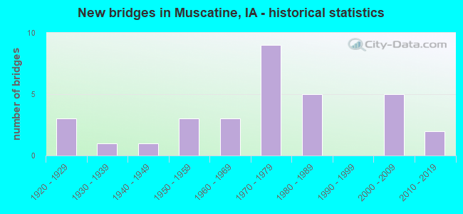
- New bridges - historical statistics
- 31920-1929
- 11930-1939
- 11940-1949
- 31950-1959
- 31960-1969
- 91970-1979
- 51980-1989
- 52000-2009
- 22010-2019
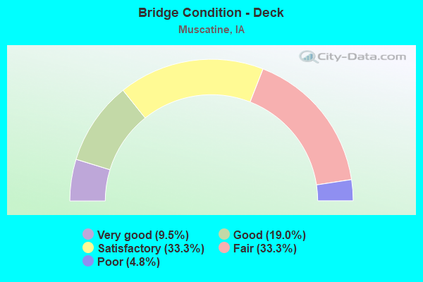
- Bridge Condition - Deck
- 9.5%Very good
- 19.0%Good
- 33.3%Satisfactory
- 33.3%Fair
- 4.8%Poor
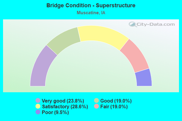
- Bridge Condition - Superstructure
- 23.8%Very good
- 19.0%Good
- 28.6%Satisfactory
- 19.0%Fair
- 9.5%Poor
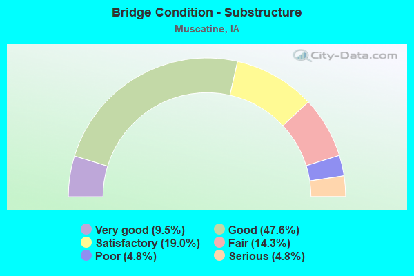
- Bridge Condition - Substructure
- 9.5%Very good
- 47.6%Good
- 19.0%Satisfactory
- 14.3%Fair
- 4.8%Poor
- 4.8%Serious
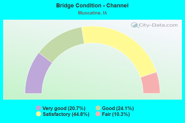
- Bridge Condition - Channel
- 20.7%Very good
- 24.1%Good
- 44.8%Satisfactory
- 10.3%Fair
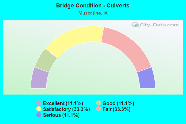
- Bridge Condition - Culverts
- 11.1%Excellent
- 11.1%Good
- 33.3%Satisfactory
- 33.3%Fair
- 11.1%Serious
Find on map >> Show street view
Structure Number: 8421, Location: 000000000 (Lat: 41.429514, Lng: -91.037681), Route carried "on" structure: City street , Year Built: 2006, Status: Open, Structure Length: 3.96m (12.99ft), Average Daily Traffic: 4,190 (year 2014), Average Future Daily Traffic: 4,190 (year 2041), Design Load: HS 20, Features Intersected: MAD CREEK, Facility Carried by Structure: 5TH ST
Minimum Vertical Clearance: 30+ m (98+ ft), Kilometerpoint: 1.078, Lanes on structure: 2, Owner: City or Municipal Highway Agency, Approaching Roadway Width: 8.2m (26.9ft), Skew: 3 degrees, Material/Design: Concrete continuous, Design/Construction: Slab, Number Of Spans In Main Unit: 3, Length of Maximum Span: 18.3m (60.0ft), Curb or Sidewalk Widths: Left: 1.2m (3.9ft), Right: 1.2m (3.9ft), Curb-To-Curb Width: 7.9m (25.9ft), Out-to-Out Width: 11.0m (36.1ft)
Condition: Deck: Satisfactory, Superstructure: Good, Substructure: Very good, Channel: Very good, Operating Rating: 71.7 metric tons, Method Used To Determine Operating Rating: Load Factor (LF), Inventory Rating: 42.9 metric tons, Method Used To Determine Inventory Rating: Load Factor (LF), Structural Evaluation: Better than present minimum criteria, Deck Geometry: High priority of corrective action, Waterway Adequacy: High priority of corrective action, Approach Roadway Alignment: Equal to present minimum criteria, Length Of Structure Improvement: 9.30m (30.51ft), Designated Inspection Frequency: Every 24 months, Inspection Date: November 2021, Bridge Improvement Cost: $350,000, Roadway Improvement Cost: $86,000, Deck Structure Type: Concrete Cast-file-Place, Wearing Surface/Protective System: Wearing Surface: Monolithic Concrete
Find on map >> Show street view
Structure Number: 8431, Location: 000000000 (Lat: 41.433972, Lng: -91.037936), Route carried "on" structure: City street , Year Built: 1986, Status: Open, Structure Length: 3.05m (10.01ft), Average Daily Traffic: 8,300 (year 2018), Average Future Daily Traffic: 8,300 (year 2041), Design Load: HS 20, Features Intersected: MAD CREEK, Facility Carried by Structure: WASHNGTON ST.
Minimum Vertical Clearance: 30+ m (98+ ft), Kilometerpoint: 0.259, Lanes on structure: 2, Owner: City or Municipal Highway Agency, Approaching Roadway Width: 8.5m (27.9ft), Skew: 3 degrees, Material/Design: Concrete continuous, Design/Construction: Slab, Number Of Spans In Main Unit: 3, Length of Maximum Span: 11.9m (39.0ft), Curb or Sidewalk Widths: Left: 1.5m (4.9ft), Right: 1.5m (4.9ft), Curb-To-Curb Width: 9.8m (32.2ft), Out-to-Out Width: 14.4m (47.2ft)
Condition: Deck: Satisfactory, Superstructure: Satisfactory, Substructure: Good, Channel: Satisfactory, Operating Rating: 53.2 metric tons, Method Used To Determine Operating Rating: Allowable Stress (AS), Inventory Rating: 33.3 metric tons, Method Used To Determine Inventory Rating: Allowable Stress (AS), Structural Evaluation: Equal to present minimum criteria, Deck Geometry: Meets minimum limits, Waterway Adequacy: Equal to present minimum criteria, Approach Roadway Alignment: Better than present minimum criteria, Designated Inspection Frequency: Every 24 months, Inspection Date: November 2021, Deck Structure Type: Concrete Cast-file-Place, Wearing Surface/Protective System: Wearing Surface: Monolithic Concrete
Find on map >> Show street view
Structure Number: 844, Location: 000000000 (Lat: 41.441411, Lng: -91.040108), Route carried "on" structure: City street , Year Built: 1957, Year Reconstructed: 2010, Status: Open, Structure Length: 2.04m (6.69ft), Average Daily Traffic: 5,100 (year 2018), Average Future Daily Traffic: 5,100 (year 2041), Design Load: HS 20, Features Intersected: MAD CREEK, Facility Carried by Structure: CLAY ST
Minimum Vertical Clearance: 30+ m (98+ ft), Kilometerpoint: 0.198, Lanes on structure: 2, Owner: City or Municipal Highway Agency, Approaching Roadway Width: 11.9m (39.0ft), Material/Design: Prestressed concrete, Design/Construction: Stringer/Multi-beam, Number Of Spans In Main Unit: 1, Length of Maximum Span: 19.5m (64.0ft), Curb or Sidewalk Widths: Left: 1.2m (3.9ft), Right: 1.2m (3.9ft), Curb-To-Curb Width: 11.2m (36.7ft), Out-to-Out Width: 14.3m (46.9ft)
Condition: Deck: Very good, Superstructure: Good, Substructure: Fair, Channel: Very good, Operating Rating: 54.3 metric tons, Method Used To Determine Operating Rating: Allowable Stress (AS), Inventory Rating: 31.0 metric tons, Method Used To Determine Inventory Rating: Allowable Stress (AS), Structural Evaluation: Somewhat better than minimum adequacy, Deck Geometry: Meets minimum limits, Waterway Adequacy: Equal to present minimum criteria, Approach Roadway Alignment: Equal to present desirable criteria, Length Of Structure Improvement: 7.50m (24.61ft), Designated Inspection Frequency: Every 24 months, Inspection Date: November 2021, Bridge Improvement Cost: $218,000, Roadway Improvement Cost: $67,000, Deck Structure Type: Concrete Cast-file-Place, Wearing Surface/Protective System: Wearing Surface: Bituminous
Find on map >> Show street view
Structure Number: 845, Location: 000000000 (Lat: 41.444667, Lng: -91.040044), Route carried "on" structure: City street , Year Built: 1973, Status: Open, Structure Length: 5.85m (19.19ft), Average Daily Traffic: 2,750 (year 2018), Average Future Daily Traffic: 2,750 (year 2041), Design Load: HS 20, Features Intersected: MAD CREEK, Facility Carried by Structure: LAKE PARK BLVD
Minimum Vertical Clearance: 30+ m (98+ ft), Kilometerpoint: 0.285, Lanes on structure: 2, Owner: City or Municipal Highway Agency, Approaching Roadway Width: 10.1m (33.1ft), Skew: 3 degrees, Material/Design: Prestressed concrete, Design/Construction: Stringer/Multi-beam, Number Of Spans In Main Unit: 3, Length of Maximum Span: 21.0m (68.9ft), Curb-To-Curb Width: 9.1m (29.9ft), Out-to-Out Width: 9.8m (32.2ft)
Condition: Deck: Fair, Superstructure: Satisfactory, Substructure: Good, Channel: Satisfactory, Operating Rating: 69.8 metric tons, Method Used To Determine Operating Rating: Allowable Stress (AS), Inventory Rating: 33.5 metric tons, Method Used To Determine Inventory Rating: Allowable Stress (AS), Structural Evaluation: Equal to present minimum criteria, Deck Geometry: Meets minimum limits, Waterway Adequacy: Better than present minimum criteria, Approach Roadway Alignment: Equal to present minimum criteria, Designated Inspection Frequency: Every 24 months, Inspection Date: November 2021, Deck Structure Type: Concrete Cast-file-Place, Wearing Surface/Protective System: Wearing Surface: Monolithic Concrete
Find on map >> Show street view
Structure Number: 8461, Location: 000000000 (Lat: 41.449131, Lng: -91.055200), Route carried "on" structure: City street , Year Built: 1980, Status: Open, Structure Length: 3.05m (10.01ft), Average Daily Traffic: 1,510 (year 2018), Average Future Daily Traffic: 1,510 (year 2041), Design Load: HS 20, Features Intersected: GENEVA CREEK, Facility Carried by Structure: BIDWELL RD
Minimum Vertical Clearance: 30+ m (98+ ft), Kilometerpoint: 1.561, Lanes on structure: 2, Owner: City or Municipal Highway Agency, Approaching Roadway Width: 8.5m (27.9ft), Skew: 1 degrees, Material/Design: Concrete continuous, Design/Construction: Slab, Number Of Spans In Main Unit: 3, Length of Maximum Span: 11.9m (39.0ft), Curb-To-Curb Width: 12.2m (40.0ft), Out-to-Out Width: 13.2m (43.3ft)
Condition: Deck: Satisfactory, Superstructure: Satisfactory, Substructure: Satisfactory, Channel: Good, Operating Rating: 49.6 metric tons, Method Used To Determine Operating Rating: Allowable Stress (AS), Inventory Rating: 30.8 metric tons, Method Used To Determine Inventory Rating: Allowable Stress (AS), Structural Evaluation: Equal to present minimum criteria, Deck Geometry: Better than present minimum criteria, Waterway Adequacy: Superior to present desirable criteria, Approach Roadway Alignment: Better than present minimum criteria, Designated Inspection Frequency: Every 24 months, Inspection Date: November 2021, Deck Structure Type: Concrete Cast-file-Place, Wearing Surface/Protective System: Wearing Surface: Monolithic Concrete, Deck Protection: Epoxy Coated Reinforcing
Find on map >> Show street view
Structure Number: 8471, Location: 000000000 (Lat: 41.439769, Lng: -91.043011), Route carried "on" structure: City street , Year Built: 1980, Status: Open, Structure Length: 2.29m (7.51ft), Average Daily Traffic: 12,300 (year 2018), Average Future Daily Traffic: 12,300 (year 2041), Design Load: HS 20, Features Intersected: GENEVA CREEK, Facility Carried by Structure: ISETT AVE
Minimum Vertical Clearance: 30+ m (98+ ft), Kilometerpoint: 0.684, Lanes on structure: 2, Owner: City or Municipal Highway Agency, Approaching Roadway Width: 12.2m (40.0ft), Skew: 3 degrees, Material/Design: Concrete continuous, Design/Construction: Slab, Number Of Spans In Main Unit: 3, Length of Maximum Span: 8.8m (28.9ft), Curb or Sidewalk Widths: Left: 1.2m (3.9ft), Right: 1.2m (3.9ft), Curb-To-Curb Width: 15.2m (49.9ft), Out-to-Out Width: 18.9m (62.0ft)
Condition: Deck: Fair, Superstructure: Fair, Substructure: Good, Channel: Fair, Operating Rating: 53.3 metric tons, Method Used To Determine Operating Rating: Allowable Stress (AS), Inventory Rating: 31.1 metric tons, Method Used To Determine Inventory Rating: Allowable Stress (AS), Structural Evaluation: Somewhat better than minimum adequacy, Deck Geometry: Superior to present desirable criteria, Waterway Adequacy: Somewhat better than minimum adequacy, Approach Roadway Alignment: Better than present minimum criteria, Designated Inspection Frequency: Every 24 months, Inspection Date: November 2021, Deck Structure Type: Concrete Cast-file-Place, Wearing Surface/Protective System: Wearing Surface: Monolithic Concrete, Deck Protection: Epoxy Coated Reinforcing
Find on map >> Show street view
Structure Number: 3795, Location: 3.4 MI. E OF W JCT. US 61 (Lat: 41.425922, Lng: -91.037414), Route carried "on" structure: City street , Year Built: 1963, Status: Open, Structure Length: 2.99m (9.81ft), Average Daily Traffic: 9,200 (year 2014), Average Future Daily Traffic: 9,200 (year 2041), Design Load: HS 20, Features Intersected: MAD CREEK, Facility Carried by Structure: E 2ND ST
Minimum Vertical Clearance: 30+ m (98+ ft), Kilometerpoint: 0.417, Lanes on structure: 4, Owner: City or Municipal Highway Agency, Approaching Roadway Width: 13.7m (44.9ft), Material/Design: Prestressed concrete, Design/Construction: Stringer/Multi-beam, Number Of Spans In Main Unit: 2, Length of Maximum Span: 15.2m (49.9ft), Curb or Sidewalk Widths: Left: 1.2m (3.9ft), Right: 1.2m (3.9ft), Curb-To-Curb Width: 14.6m (47.9ft), Out-to-Out Width: 17.7m (58.1ft)
Condition: Deck: Satisfactory, Superstructure: Satisfactory, Substructure: Good, Channel: Good, Operating Rating: 62.9 metric tons, Method Used To Determine Operating Rating: Load Factor (LF), Inventory Rating: 37.6 metric tons, Method Used To Determine Inventory Rating: Load Factor (LF), Structural Evaluation: Equal to present minimum criteria, Deck Geometry: High priority of replacement, Waterway Adequacy: Equal to present minimum criteria, Approach Roadway Alignment: Equal to present minimum criteria, Designated Inspection Frequency: Every 24 months, Inspection Date: November 2021, Deck Structure Type: Concrete Cast-file-Place, Wearing Surface/Protective System: Wearing Surface: Low Slump Concrete
Find on map >> Show street view
Structure Number: 38021, Location: 2.1 mi. E of jct. Bus. 61 (Lat: 41.443933, Lng: -90.993731), Route carried "on" structure: State highway 22, Year Built: 1984, Status: Open, Structure Length: 0.73m (2.40ft), Average Daily Traffic: 2,630 (year 2020), Truck Traffic: 10%, Average Future Daily Traffic: 2,630 (year 2040), Design Load: HS 20, Features Intersected: ROCK CREEK
Minimum Vertical Clearance: 30+ m (98+ ft), Kilometerpoint: 123.755, Lanes on structure: 2, Base Highway Network: Yes, Owner: State Highway Agency, Approaching Roadway Width: 10.1m (33.1ft), Skew: 3 degrees, Material/Design: Concrete continuous, Design/Construction: Culvert, Number Of Spans In Main Unit: 2, Length of Maximum Span: 3.0m (9.8ft)
Condition: Channel: Satisfactory, Culverts: Good, Operating Rating: 39.5 metric tons, Method Used To Determine Operating Rating: Load and Resistance Factor Rating (LRFR) rating reported by rating factor(RF) method using HL-93 loadings, Inventory Rating: 30.5 metric tons, Method Used To Determine Inventory Rating: Load and Resistance Factor Rating (LRFR) rating reported by rating factor(RF) method using HL-93 loadings, Structural Evaluation: Better than present minimum criteria, Waterway Adequacy: Equal to present desirable criteria, Approach Roadway Alignment: Meets minimum limits, Designated Inspection Frequency: Every 24 months, Inspection Date: June 2020
Find on map >> Show street view
Structure Number: 3803, Location: 2.9 mi. E of jct. IA #38 (Lat: 41.444806, Lng: -90.978197), Route carried "on" structure: State highway 22, Year Built: 1967, Status: Open, Structure Length: 0.85m (2.79ft), Average Daily Traffic: 1,220 (year 2020), Truck Traffic: 19%, Average Future Daily Traffic: 1,220 (year 2041), Design Load: HS 20, Features Intersected: STREAM
Minimum Vertical Clearance: 30+ m (98+ ft), Kilometerpoint: 125.065, Lanes on structure: 2, Base Highway Network: Yes, Owner: State Highway Agency, Approaching Roadway Width: 13.4m (44.0ft), Skew: 4 degrees, Material/Design: Concrete, Design/Construction: Slab, Number Of Spans In Main Unit: 1, Length of Maximum Span: 8.5m (27.9ft), Curb-To-Curb Width: 13.2m (43.3ft), Out-to-Out Width: 14.0m (45.9ft)
Condition: Deck: Satisfactory, Superstructure: Satisfactory, Substructure: Satisfactory, Channel: Fair, Operating Rating: 64.9 metric tons, Method Used To Determine Operating Rating: Load Factor (LF), Inventory Rating: 39.0 metric tons, Method Used To Determine Inventory Rating: Load Factor (LF), Structural Evaluation: Equal to present minimum criteria, Deck Geometry: Better than present minimum criteria, Waterway Adequacy: Equal to present minimum criteria, Approach Roadway Alignment: Equal to present desirable criteria, Designated Inspection Frequency: Every 24 months, Inspection Date: March 2021, Deck Structure Type: Concrete Cast-file-Place, Wearing Surface/Protective System: Wearing Surface: Low Slump Concrete
Find on map >> Show street view
Structure Number: 38041, Location: 3.5 MI. E of Jct. IA 38 (Lat: 41.441997, Lng: -90.967056), Route carried "on" structure: State highway 22, Year Built: 1978, Status: Open, Structure Length: 0.67m (2.20ft), Average Daily Traffic: 1,220 (year 2020), Truck Traffic: 19%, Average Future Daily Traffic: 1,220 (year 2041), Design Load: HS 20, Features Intersected: DRAINAGE DITCH
Minimum Vertical Clearance: 30+ m (98+ ft), Kilometerpoint: 126.057, Lanes on structure: 2, Base Highway Network: Yes, Owner: State Highway Agency, Approaching Roadway Width: 10.7m (35.1ft), Material/Design: Concrete continuous, Design/Construction: Culvert, Number Of Spans In Main Unit: 2, Length of Maximum Span: 3.0m (9.8ft), Curb-To-Curb Width: 13.4m (44.0ft), Out-to-Out Width: 14.4m (47.2ft)
Condition: Channel: Satisfactory, Culverts: Satisfactory, Operating Rating: 42.4 metric tons, Method Used To Determine Operating Rating: Load Factor (LF), Inventory Rating: 25.4 metric tons, Method Used To Determine Inventory Rating: Load Factor (LF), Structural Evaluation: Equal to present minimum criteria, Deck Geometry: Equal to present desirable criteria, Waterway Adequacy: Equal to present desirable criteria, Approach Roadway Alignment: Equal to present minimum criteria, Designated Inspection Frequency: Every 24 months, Inspection Date: March 2021, Deck Structure Type: Concrete Cast-file-Place, Wearing Surface/Protective System: Wearing Surface: Bituminous
Find on map >> Show street view
Structure Number: 38051, Location: 4.2 MI. E OF JCT. IA 38 (Lat: 41.437597, Lng: -90.956361), Route carried "on" structure: State highway 22, Year Built: 1978, Status: Open, Structure Length: 4.57m (14.99ft), Average Daily Traffic: 1,220 (year 2020), Truck Traffic: 19%, Average Future Daily Traffic: 1,220 (year 2041), Design Load: HS 20, Features Intersected: SWEETLAND CREEK
Minimum Vertical Clearance: 30+ m (98+ ft), Kilometerpoint: 127.075, Lanes on structure: 2, Base Highway Network: Yes, Owner: State Highway Agency, Approaching Roadway Width: 13.4m (44.0ft), Material/Design: Prestressed concrete, Design/Construction: Stringer/Multi-beam, Number Of Spans In Main Unit: 3, Length of Maximum Span: 21.0m (68.9ft), Curb-To-Curb Width: 13.4m (44.0ft), Out-to-Out Width: 14.5m (47.6ft)
Condition: Deck: Satisfactory, Superstructure: Good, Substructure: Good, Channel: Satisfactory, Operating Rating: 57.1 metric tons, Method Used To Determine Operating Rating: Allowable Stress (AS), Inventory Rating: 34.6 metric tons, Method Used To Determine Inventory Rating: Allowable Stress (AS), Structural Evaluation: Better than present minimum criteria, Deck Geometry: Equal to present desirable criteria, Waterway Adequacy: Equal to present desirable criteria, Approach Roadway Alignment: Equal to present desirable criteria, Designated Inspection Frequency: Every 24 months, Underwater Inspection Frequency: Every 72 months, Inspection Date: March 2021, Underwater Inspection Date: March 2019, Deck Structure Type: Concrete Cast-file-Place, Wearing Surface/Protective System: Wearing Surface: Monolithic Concrete, Deck Protection: Epoxy Coated Reinforcing
Find on map >> Show street view
Structure Number: 38151, Location: 0.6 MI. N OF JCT. US 61 (Lat: 41.459714, Lng: -91.031333), Route carried "on" structure: State highway 38, Year Built: 1972, Status: Open, Structure Length: 5.61m (18.41ft), Average Daily Traffic: 7,800 (year 2020), Truck Traffic: 8%, Average Future Daily Traffic: 7,800 (year 2041), Design Load: HS 20, Features Intersected: MAD CREEK
Minimum Vertical Clearance: 30+ m (98+ ft), Kilometerpoint: 3.883, Lanes on structure: 2, Base Highway Network: Yes, Owner: State Highway Agency, Approaching Roadway Width: 13.4m (44.0ft), Skew: 3 degrees, Material/Design: Prestressed concrete, Design/Construction: Stringer/Multi-beam, Number Of Spans In Main Unit: 3, Length of Maximum Span: 19.8m (65.0ft), Curb-To-Curb Width: 13.4m (44.0ft), Out-to-Out Width: 14.4m (47.2ft)
Condition: Deck: Fair, Superstructure: Good, Substructure: Good, Channel: Satisfactory, Operating Rating: 57.0 metric tons, Method Used To Determine Operating Rating: Load Factor (LF), Inventory Rating: 34.1 metric tons, Method Used To Determine Inventory Rating: Load Factor (LF), Structural Evaluation: Better than present minimum criteria, Deck Geometry: Equal to present minimum criteria, Waterway Adequacy: Better than present minimum criteria, Approach Roadway Alignment: Better than present minimum criteria, Designated Inspection Frequency: Every 24 months, Inspection Date: March 2021, Deck Structure Type: Concrete Cast-file-Place, Wearing Surface/Protective System: Wearing Surface: Low Slump Concrete
Find on map >> Show street view
Structure Number: 38201, Location: IN MUSCATINE (Lat: 41.426536, Lng: -91.035833), Route carried "on" structure: State highway 92, Year Built: 1972, Status: Open, Structure Length: 91.99m (301.80ft), Average Daily Traffic: 3,340 (year 2020), Truck Traffic: 8%, Average Future Daily Traffic: 3,340 (year 2041), Design Load: HS 20, Features Intersected: MISSISSIPPI RIVER & RR
Minimum Vertical Clearance: 5.21m (17.09ft), Kilometerpoint: 449.554, Lanes on structure: 2, Base Highway Network: Yes, Owner: State Highway Agency, Approaching Roadway Width: 9.8m (32.2ft), Navigation Control: Yes ( Vertical Clearance: 19.8m (65.0ft), Horizontal Clearance: 152.4m (500.0ft)), Material/Design: Steel, Design/Construction: Truss - Thru, Number Of Spans In Main Unit: 1, Number Of Approach Spans: 23, Length of Maximum Span: 156.1m (512.1ft), Curb-To-Curb Width: 9.8m (32.2ft), Out-to-Out Width: 10.8m (35.4ft)
Condition: Deck: Fair, Superstructure: Fair, Substructure: Fair, Channel: Good, Operating Rating: 44.1 metric tons, Method Used To Determine Operating Rating: Load Factor (LF), Inventory Rating: 32.7 metric tons, Method Used To Determine Inventory Rating: Load Factor (LF), Structural Evaluation: Somewhat better than minimum adequacy, Deck Geometry: Meets minimum limits, Underclear: Superior to present desirable criteria, Waterway Adequacy: Equal to present desirable criteria, Approach Roadway Alignment: Equal to present minimum criteria, Designated Inspection Frequency: Every 24 months, Critical Feature Inspection Frequency: Every 24 months, Underwater Inspection Frequency: Every 60 months, Inspection Date: August 2021, Critical Feature Inspection Date: August 2021, Underwater Inspection Date: July 2020, Deck Structure Type: Concrete Cast-file-Place, Wearing Surface/Protective System: Wearing Surface: Low Slump Concrete
Find on map >> Show street view
Structure Number: 256942, Location: 076020619 (Lat: 41.415314, Lng: -91.118497), Route carried "on" structure: County highway , Year Built: 2015, Status: Open, Structure Length: 2.23m (7.32ft), Average Daily Traffic: 330 (year 2018), Average Future Daily Traffic: 330 (year 2041), Design Load: HL 93, Features Intersected: KINCAID CREEK, Facility Carried by Structure: BURLINGTON RD
Minimum Vertical Clearance: 30+ m (98+ ft), Kilometerpoint: 12.635, Lanes on structure: 2, Owner: County Highway Agency, Approaching Roadway Width: 10.4m (34.1ft), Material/Design: Concrete continuous, Design/Construction: Slab, Number Of Spans In Main Unit: 3, Length of Maximum Span: 8.5m (27.9ft), Curb-To-Curb Width: 9.3m (30.5ft), Out-to-Out Width: 10.1m (33.1ft)
Condition: Deck: Very good, Superstructure: Very good, Substructure: Very good, Channel: Very good, Operating Rating: 42.1 metric tons, Method Used To Determine Operating Rating: Assigned ratings based on Load and Resistance Factor Design (LRFD) reported by rating factor (RF) using HL93 loadings, Inventory Rating: 32.4 metric tons, Method Used To Determine Inventory Rating: Assigned ratings based on Load and Resistance Factor Design (LRFD) reported by rating factor (RF) using HL93 loadings, Structural Evaluation: Equal to present desirable criteria, Deck Geometry: Equal to present minimum criteria, Waterway Adequacy: Superior to present desirable criteria, Approach Roadway Alignment: Equal to present minimum criteria, Designated Inspection Frequency: Every 48 months, Inspection Date: September 2021, Deck Structure Type: Concrete Cast-file-Place, Wearing Surface/Protective System: Wearing Surface: Monolithic Concrete, Deck Protection: Epoxy Coated Reinforcing
Find on map >> Show street view
Structure Number: 25702, Location: 076020702 (Lat: 41.401439, Lng: -91.137786), Route carried "on" structure: ServiceCounty highway , Year Built: 1920, Status: Open, Structure Length: 0.64m (2.10ft), Average Daily Traffic: 10 (year 2014), Average Future Daily Traffic: 35 (year 2041), Features Intersected: DRAINAGE DITCH(SDB), Facility Carried by Structure: FARM ENTRANCE
Minimum Vertical Clearance: 30+ m (98+ ft), Kilometerpoint: 3.598, Lanes on structure: 2, Owner: County Highway Agency, Approaching Roadway Width: 4.9m (16.1ft), Material/Design: Steel, Design/Construction: Stringer/Multi-beam, Number Of Spans In Main Unit: 1, Length of Maximum Span: 6.1m (20.0ft), Curb-To-Curb Width: 4.9m (16.1ft), Out-to-Out Width: 4.9m (16.1ft)
Condition: Deck: Poor, Superstructure: Poor, Substructure: Poor, Channel: Satisfactory, Operating Rating: 10.4 metric tons, Method Used To Determine Operating Rating: Allowable Stress (AS), Inventory Rating: 7.2 metric tons, Method Used To Determine Inventory Rating: Allowable Stress (AS), Structural Evaluation: High priority of replacement, Deck Geometry: High priority of corrective action, Waterway Adequacy: Better than present minimum criteria, Approach Roadway Alignment: Better than present minimum criteria, Bridge Posting: Required (Relationship of Operating Rating to Maximum Legal Load: > 39.9% below), Length Of Structure Improvement: 4.00m (13.12ft), Designated Inspection Frequency: Every 24 months, Inspection Date: September 2021, Bridge Improvement Cost: $96,000, Roadway Improvement Cost: $10,000, Deck Structure Type: Wood or Timber, Wearing Surface/Protective System: Wearing Surface: Wood or Timber
Find on map >> Show street view
Structure Number: 25703, Location: 076020703 (Lat: 41.393122, Lng: -91.132878), Route carried "on" structure: County highway , Year Built: 1968, Status: Open, Structure Length: 3.87m (12.70ft), Average Daily Traffic: 60 (year 2014), Average Future Daily Traffic: 60 (year 2041), Design Load: H 20, Features Intersected: DRAINAGE DITCH 13, Facility Carried by Structure: LOCAL
Minimum Vertical Clearance: 30+ m (98+ ft), Kilometerpoint: 0.401, Lanes on structure: 2, Owner: County Highway Agency, Approaching Roadway Width: 9.1m (29.9ft), Skew: 1 degrees, Material/Design: Concrete continuous, Design/Construction: Slab, Number Of Spans In Main Unit: 3, Length of Maximum Span: 14.9m (48.9ft), Curb-To-Curb Width: 8.5m (27.9ft), Out-to-Out Width: 9.1m (29.9ft)
Condition: Deck: Fair, Superstructure: Fair, Substructure: Satisfactory, Channel: Satisfactory, Operating Rating: 52.2 metric tons, Method Used To Determine Operating Rating: Allowable Stress (AS), Inventory Rating: 30.4 metric tons, Method Used To Determine Inventory Rating: Allowable Stress (AS), Structural Evaluation: Somewhat better than minimum adequacy, Deck Geometry: Better than present minimum criteria, Waterway Adequacy: Better than present minimum criteria, Approach Roadway Alignment: Better than present minimum criteria, Length Of Structure Improvement: 12.50m (41.01ft), Designated Inspection Frequency: Every 24 months, Inspection Date: September 2021, Bridge Improvement Cost: $15,000, Roadway Improvement Cost: $2,000, Deck Structure Type: Concrete Cast-file-Place, Wearing Surface/Protective System: Wearing Surface: Monolithic Concrete
Find on map >> Show street view
Structure Number: 257091, Location: 076032403 (Lat: 41.378161, Lng: -91.149200), Route carried "on" structure: County highway , Year Built: 1975, Status: Open, Structure Length: 3.90m (12.80ft), Average Daily Traffic: 230 (year 2014), Truck Traffic: 17%, Average Future Daily Traffic: 230 (year 2041), Design Load: H 20, Features Intersected: MUSCATINE SLOUGH, Facility Carried by Structure: LOCAL
Minimum Vertical Clearance: 30+ m (98+ ft), Kilometerpoint: 2.977, Lanes on structure: 2, Owner: County Highway Agency, Approaching Roadway Width: 6.1m (20.0ft), Skew: 4 degrees, Material/Design: Concrete continuous, Design/Construction: Slab, Number Of Spans In Main Unit: 3, Length of Maximum Span: 14.9m (48.9ft), Curb-To-Curb Width: 8.5m (27.9ft), Out-to-Out Width: 9.1m (29.9ft)
Condition: Deck: Satisfactory, Superstructure: Satisfactory, Substructure: Satisfactory, Channel: Good, Operating Rating: 52.2 metric tons, Method Used To Determine Operating Rating: Allowable Stress (AS), Inventory Rating: 30.4 metric tons, Method Used To Determine Inventory Rating: Allowable Stress (AS), Structural Evaluation: Equal to present minimum criteria, Deck Geometry: Equal to present minimum criteria, Waterway Adequacy: Better than present minimum criteria, Approach Roadway Alignment: Better than present minimum criteria, Length Of Structure Improvement: 12.80m (41.99ft), Designated Inspection Frequency: Every 24 months, Inspection Date: September 2021, Bridge Improvement Cost: $15,000, Roadway Improvement Cost: $2,000, Deck Structure Type: Concrete Cast-file-Place, Wearing Surface/Protective System: Wearing Surface: Monolithic Concrete
Find on map >> Show street view
Structure Number: 25742, Location: 077011501 (Lat: 41.478667, Lng: -90.952275), Route carried "on" structure: County highway , Year Built: 1937, Status: Open, Structure Length: 0.64m (2.10ft), Average Daily Traffic: 80 (year 2018), Average Future Daily Traffic: 80 (year 2041), Features Intersected: SWEETLAND CREEK, Facility Carried by Structure: FM
Minimum Vertical Clearance: 30+ m (98+ ft), Kilometerpoint: 19.283, Lanes on structure: 2, Owner: County Highway Agency, Approaching Roadway Width: 8.2m (26.9ft), Material/Design: Concrete continuous, Design/Construction: Culvert, Number Of Spans In Main Unit: 2, Length of Maximum Span: 3.0m (9.8ft)
Condition: Channel: Fair, Culverts: Fair, Operating Rating: 55.9 metric tons, Method Used To Determine Operating Rating: Load Factor (LF), Inventory Rating: 33.5 metric tons, Method Used To Determine Inventory Rating: Load Factor (LF), Structural Evaluation: Somewhat better than minimum adequacy, Waterway Adequacy: Equal to present minimum criteria, Approach Roadway Alignment: Equal to present minimum criteria, Length Of Structure Improvement: 4.00m (13.12ft), Designated Inspection Frequency: Every 24 months, Inspection Date: September 2021, Bridge Improvement Cost: $96,000, Roadway Improvement Cost: $10,000
Find on map >> Show street view
Structure Number: 25743, Location: 077021303 (Lat: 41.478783, Lng: -91.019944), Route carried "on" structure: County highway , Year Built: 1950, Status: Open, Structure Length: 0.64m (2.10ft), Average Daily Traffic: 310 (year 2014), Truck Traffic: 5%, Average Future Daily Traffic: 310 (year 2041), Design Load: H 20, Features Intersected: SMALL STREAM, Facility Carried by Structure: FM
Minimum Vertical Clearance: 30+ m (98+ ft), Kilometerpoint: 13.750, Lanes on structure: 2, Owner: County Highway Agency, Approaching Roadway Width: 9.1m (29.9ft), Material/Design: Concrete continuous, Design/Construction: Culvert, Number Of Spans In Main Unit: 2, Length of Maximum Span: 3.0m (9.8ft)
Condition: Channel: Satisfactory, Culverts: Fair, Inventory Rating: 84.4 metric tons, Method Used To Determine Inventory Rating: Load Factor (LF), Structural Evaluation: Somewhat better than minimum adequacy, Waterway Adequacy: Better than present minimum criteria, Approach Roadway Alignment: Equal to present minimum criteria, Length Of Structure Improvement: 4.80m (15.75ft), Designated Inspection Frequency: Every 24 months, Inspection Date: September 2021, Bridge Improvement Cost: $144,000, Roadway Improvement Cost: $14,000
Find on map >> Show street view
Structure Number: 25744, Location: 077012203 (Lat: 41.463961, Lng: -90.950619), Route carried "on" structure: County highway , Year Built: 1948, Status: Open, Structure Length: 0.61m (2.00ft), Average Daily Traffic: 400 (year 2018), Truck Traffic: 8%, Average Future Daily Traffic: 400 (year 2041), Design Load: H 15, Features Intersected: SWEETLAND CREEK, Facility Carried by Structure: FM
Minimum Vertical Clearance: 30+ m (98+ ft), Kilometerpoint: 4.809, Lanes on structure: 2, Owner: County Highway Agency, Approaching Roadway Width: 10.7m (35.1ft), Material/Design: Concrete continuous, Design/Construction: Culvert, Number Of Spans In Main Unit: 1, Length of Maximum Span: 6.1m (20.0ft)
Condition: Channel: Satisfactory, Culverts: Satisfactory, Operating Rating: 44.4 metric tons, Method Used To Determine Operating Rating: Load Factor (LF), Inventory Rating: 26.6 metric tons, Method Used To Determine Inventory Rating: Load Factor (LF), Structural Evaluation: Equal to present minimum criteria, Waterway Adequacy: Better than present minimum criteria, Approach Roadway Alignment: Better than present minimum criteria, Length Of Structure Improvement: 4.00m (13.12ft), Designated Inspection Frequency: Every 24 months, Inspection Date: September 2021, Bridge Improvement Cost: $120,000, Roadway Improvement Cost: $12,000
Find on map >> Show street view
Structure Number: 25746, Location: 077012804 (Lat: 41.445817, Lng: -90.978928), Route carried "on" structure: County highway , Year Built: 1970, Status: Open, Structure Length: 0.64m (2.10ft), Average Daily Traffic: 550 (year 2018), Truck Traffic: 8%, Average Future Daily Traffic: 550 (year 2039), Design Load: H 20, Features Intersected: CREEK, Facility Carried by Structure: FM
Minimum Vertical Clearance: 30+ m (98+ ft), Kilometerpoint: 0.124, Lanes on structure: 2, Owner: County Highway Agency, Approaching Roadway Width: 10.4m (34.1ft), Skew: 3 degrees, Material/Design: Concrete continuous, Design/Construction: Culvert, Number Of Spans In Main Unit: 2, Length of Maximum Span: 3.0m (9.8ft)
Condition: Channel: Satisfactory, Culverts: Satisfactory, Operating Rating: 56.5 metric tons, Method Used To Determine Operating Rating: Load Factor (LF), Inventory Rating: 33.8 metric tons, Method Used To Determine Inventory Rating: Load Factor (LF), Structural Evaluation: Equal to present minimum criteria, Waterway Adequacy: Better than present minimum criteria, Approach Roadway Alignment: Somewhat better than minimum adequacy, Length Of Structure Improvement: 2.10m (6.89ft), Designated Inspection Frequency: Every 48 months, Inspection Date: September 2019, Bridge Improvement Cost: $15,000, Roadway Improvement Cost: $2,000
Find on map >> Show street view
Structure Number: 25751, Location: 077023205 (Lat: 41.432833, Lng: -91.102867), Route carried "on" structure: County highway , Year Built: 1928, Status: Open, Structure Length: 0.76m (2.49ft), Average Daily Traffic: 440 (year 2018), Truck Traffic: 7%, Average Future Daily Traffic: 440 (year 2041), Features Intersected: LOWE RUN, Facility Carried by Structure: LOCAL
Minimum Vertical Clearance: 30+ m (98+ ft), Kilometerpoint: 1.236, Lanes on structure: 2, Owner: County Highway Agency, Approaching Roadway Width: 8.2m (26.9ft), Skew: 3 degrees, Material/Design: Concrete continuous, Design/Construction: Culvert, Number Of Spans In Main Unit: 2, Length of Maximum Span: 3.7m (12.1ft)
Condition: Channel: Satisfactory, Culverts: Serious, Operating Rating: 23.2 metric tons, Method Used To Determine Operating Rating: Field evaluation and documented engineering judgment, Structural Evaluation: High priority of replacement, Waterway Adequacy: Better than present minimum criteria, Approach Roadway Alignment: Meets minimum limits, Length Of Structure Improvement: 5.00m (16.40ft), Designated Inspection Frequency: Every 24 months, Inspection Date: September 2021, Bridge Improvement Cost: $150,000, Roadway Improvement Cost: $15,000
Find on map >> Show street view
Structure Number: 258061, Location: 078013101 (Lat: 41.522422, Lng: -91.005586), Route carried "on" structure: County highway , Year Built: 1978, Status: Posted for load, Structure Length: 0.98m (3.22ft), Average Daily Traffic: 100 (year 2014), Average Future Daily Traffic: 100 (year 2041), Design Load: H 20, Features Intersected: SMALL STREAM, Facility Carried by Structure: LOCAL
Minimum Vertical Clearance: 30+ m (98+ ft), Kilometerpoint: 7.028, Lanes on structure: 2, Owner: County Highway Agency, Approaching Roadway Width: 8.5m (27.9ft), Material/Design: Prestressed concrete, Design/Construction: Tee Beam, Number Of Spans In Main Unit: 1, Length of Maximum Span: 9.1m (29.9ft), Curb-To-Curb Width: 7.3m (24.0ft), Out-to-Out Width: 7.3m (24.0ft)
Condition: Deck: Fair, Superstructure: Fair, Substructure: Serious, Channel: Satisfactory, Operating Rating: 3.6 metric tons, Method Used To Determine Operating Rating: Allowable Stress (AS), Structural Evaluation: High priority of replacement, Deck Geometry: Equal to present minimum criteria, Waterway Adequacy: Equal to present minimum criteria, Approach Roadway Alignment: Better than present minimum criteria, Bridge Posting: Required (Relationship of Operating Rating to Maximum Legal Load: > 39.9% below), Length Of Structure Improvement: 5.00m (16.40ft), Designated Inspection Frequency: Every 12 months, Inspection Date: September 2021, Bridge Improvement Cost: $120,000, Roadway Improvement Cost: $12,000, Deck Structure Type: Concrete Precast Panels, Wearing Surface/Protective System: Wearing Surface: Monolithic Concrete
Find on map >> Show street view
Structure Number: 25807, Location: 078013101 (Lat: 41.522486, Lng: -90.998567), Route carried "on" structure: County highway , Year Built: 1955, Status: Open, Structure Length: 0.64m (2.10ft), Average Daily Traffic: 100 (year 2014), Average Future Daily Traffic: 100 (year 2041), Design Load: H 15, Features Intersected: CREEK, Facility Carried by Structure: LOCAL
Minimum Vertical Clearance: 30+ m (98+ ft), Kilometerpoint: 7.614, Lanes on structure: 2, Owner: County Highway Agency, Approaching Roadway Width: 6.7m (22.0ft), Material/Design: Concrete continuous, Design/Construction: Culvert, Number Of Spans In Main Unit: 2, Length of Maximum Span: 3.0m (9.8ft)
Condition: Channel: Good, Culverts: Fair, Operating Rating: 50.0 metric tons, Method Used To Determine Operating Rating: Load Factor (LF), Inventory Rating: 29.9 metric tons, Method Used To Determine Inventory Rating: Load Factor (LF), Structural Evaluation: Somewhat better than minimum adequacy, Waterway Adequacy: Equal to present minimum criteria, Approach Roadway Alignment: Equal to present minimum criteria, Length Of Structure Improvement: 4.00m (13.12ft), Designated Inspection Frequency: Every 24 months, Inspection Date: September 2021, Bridge Improvement Cost: $96,000, Roadway Improvement Cost: $10,000
Find on map >> Show street view
Structure Number: 258222, Location: 078023502 (Lat: 41.511669, Lng: -91.058397), Route carried "on" structure: County highway , Year Built: 2019, Status: Open, Structure Length: 0.73m (2.40ft), Average Daily Traffic: 90 (year 2014), Average Future Daily Traffic: 90 (year 2041), Design Load: HL 93, Features Intersected: SMALL CREEK, Facility Carried by Structure: N ISETT AVE
Minimum Vertical Clearance: 30+ m (98+ ft), Kilometerpoint: 6.874, Lanes on structure: 2, Owner: County Highway Agency, Approaching Roadway Width: 8.5m (27.9ft), Skew: 4 degrees, Material/Design: Concrete continuous, Design/Construction: Culvert, Number Of Spans In Main Unit: 2, Length of Maximum Span: 3.4m (11.2ft)
Condition: Channel: Very good, Culverts: Excellent, Operating Rating: 42.1 metric tons, Method Used To Determine Operating Rating: Assigned ratings based on Load and Resistance Factor Design (LRFD) reported by rating factor (RF) using HL93 loadings, Inventory Rating: 32.4 metric tons, Method Used To Determine Inventory Rating: Assigned ratings based on Load and Resistance Factor Design (LRFD) reported by rating factor (RF) using HL93 loadings, Structural Evaluation: Equal to present desirable criteria, Waterway Adequacy: Better than present minimum criteria, Approach Roadway Alignment: Better than present minimum criteria, Designated Inspection Frequency: Every 24 months, Inspection Date: September 2021
Find on map >> Show street view
Structure Number: 60344, Location: 000000000 (Lat: 41.459197, Lng: -91.034372), Route carried "on" structure: City street , Year Built: 1924, Status: Open, Structure Length: 1.22m (4.00ft), Average Daily Traffic: 190 (year 2014), Average Future Daily Traffic: 190 (year 2041), Features Intersected: MAD CREEK, Facility Carried by Structure: PARK AVE W
Minimum Vertical Clearance: 30+ m (98+ ft), Kilometerpoint: 0.583, Lanes on structure: 2, Owner: City or Municipal Highway Agency, Approaching Roadway Width: 5.5m (18.0ft), Material/Design: Concrete, Design/Construction: Arch - Deck, Number Of Spans In Main Unit: 1, Length of Maximum Span: 12.2m (40.0ft), Curb-To-Curb Width: 7.5m (24.6ft), Out-to-Out Width: 8.6m (28.2ft)
Condition: Deck: Fair, Superstructure: Poor, Substructure: Fair, Channel: Good, Operating Rating: 32.7 metric tons, Method Used To Determine Operating Rating: Allowable Stress (AS), Inventory Rating: 27.7 metric tons, Method Used To Determine Inventory Rating: Allowable Stress (AS), Structural Evaluation: Meets minimum limits, Deck Geometry: Somewhat better than minimum adequacy, Waterway Adequacy: Better than present minimum criteria, Approach Roadway Alignment: Better than present minimum criteria, Designated Inspection Frequency: Every 24 months, Inspection Date: November 2021
Find on map >> Show street view
Structure Number: 605155, Location: 0.5 MI. S OF JCT. IA 38 (Lat: 41.451872, Lng: -91.039092), Route carried "on" structure: US 61, Year Built: 1984, Status: Open, Structure Length: 6.89m (22.60ft), Average Daily Traffic: 16,800 (year 2020), Truck Traffic: 11%, Average Future Daily Traffic: 16,800 (year 2041), Design Load: HS 20, Features Intersected: MAD CREEK
Minimum Vertical Clearance: 30+ m (98+ ft), Kilometerpoint: 146.944, Lanes on structure: 4, Base Highway Network: Yes, Owner: State Highway Agency, Approaching Roadway Width: 26.8m (87.9ft), Skew: 22 degrees, Material/Design: Prestressed concrete, Design/Construction: Stringer/Multi-beam, Number Of Spans In Main Unit: 3, Length of Maximum Span: 25.0m (82.0ft), Curb-To-Curb Width: 26.8m (87.9ft), Out-to-Out Width: 27.8m (91.2ft)
Condition: Deck: Good, Superstructure: Very good, Substructure: Good, Channel: Good, Operating Rating: 79.5 metric tons, Method Used To Determine Operating Rating: Load Factor (LF), Inventory Rating: 36.6 metric tons, Method Used To Determine Inventory Rating: Load Factor (LF), Structural Evaluation: Better than present minimum criteria, Deck Geometry: Superior to present desirable criteria, Waterway Adequacy: Equal to present desirable criteria, Approach Roadway Alignment: Better than present minimum criteria, Designated Inspection Frequency: Every 24 months, Inspection Date: March 2021, Deck Structure Type: Concrete Cast-file-Place, Wearing Surface/Protective System: Wearing Surface: Monolithic Concrete, Deck Protection: Epoxy Coated Reinforcing
Find on map >> Show street view
Structure Number: 607235, Location: 6.7 mi. N of S Jct IA 92 (Lat: 41.348311, Lng: -91.160286), Route carried "on" structure: US 61, Year Built: 2002, Status: Open, Structure Length: 4.08m (13.39ft), Average Daily Traffic: 3,000 (year 2020), Truck Traffic: 20%, Average Future Daily Traffic: 3,000 (year 2041), Design Load: HS 20, Features Intersected: MUSCATINE SLOUGH
Minimum Vertical Clearance: 30+ m (98+ ft), Kilometerpoint: 128.384, Lanes on structure: 2, Base Highway Network: Yes, Owner: State Highway Agency, Approaching Roadway Width: 12.8m (42.0ft), Skew: 1 degrees, Material/Design: Prestressed concrete, Design/Construction: Stringer/Multi-beam, Number Of Spans In Main Unit: 3, Length of Maximum Span: 17.4m (57.1ft), Curb-To-Curb Width: 12.4m (40.7ft), Out-to-Out Width: 13.4m (44.0ft)
Condition: Deck: Good, Superstructure: Very good, Substructure: Good, Channel: Very good, Operating Rating: 63.3 metric tons, Method Used To Determine Operating Rating: Load Factor (LF), Inventory Rating: 32.7 metric tons, Method Used To Determine Inventory Rating: Load Factor (LF), Structural Evaluation: Better than present minimum criteria, Deck Geometry: Better than present minimum criteria, Waterway Adequacy: Equal to present desirable criteria, Approach Roadway Alignment: Equal to present desirable criteria, Designated Inspection Frequency: Every 24 months, Underwater Inspection Frequency: Every 48 months, Inspection Date: October 2021, Underwater Inspection Date: October 2021, Deck Structure Type: Concrete Cast-file-Place, Wearing Surface/Protective System: Wearing Surface: Monolithic Concrete, Deck Protection: Epoxy Coated Reinforcing
Find on map >> Show street view
Structure Number: 60724, Location: 6.7 mi. N of S Jct IA 92 (Lat: 41.348772, Lng: -91.160219), Route carried "on" structure: US 61, Year Built: 2002, Status: Open, Structure Length: 4.08m (13.39ft), Average Daily Traffic: 3,000 (year 2020), Truck Traffic: 20%, Average Future Daily Traffic: 3,000 (year 2041), Design Load: HS 20, Features Intersected: MUSCATINE SLOUGH
Minimum Vertical Clearance: 30+ m (98+ ft), Kilometerpoint: 180.655, Lanes on structure: 2, Owner: State Highway Agency, Approaching Roadway Width: 12.8m (42.0ft), Skew: 1 degrees, Material/Design: Prestressed concrete, Design/Construction: Stringer/Multi-beam, Number Of Spans In Main Unit: 3, Length of Maximum Span: 17.4m (57.1ft), Curb-To-Curb Width: 12.3m (40.4ft), Out-to-Out Width: 13.3m (43.6ft)
Condition: Deck: Good, Superstructure: Very good, Substructure: Good, Channel: Very good, Operating Rating: 63.4 metric tons, Method Used To Determine Operating Rating: Load Factor (LF), Inventory Rating: 32.7 metric tons, Method Used To Determine Inventory Rating: Load Factor (LF), Structural Evaluation: Better than present minimum criteria, Deck Geometry: Better than present minimum criteria, Waterway Adequacy: Equal to present desirable criteria, Approach Roadway Alignment: Equal to present desirable criteria, Designated Inspection Frequency: Every 24 months, Underwater Inspection Frequency: Every 48 months, Inspection Date: October 2021, Underwater Inspection Date: October 2021, Deck Structure Type: Concrete Cast-file-Place, Wearing Surface/Protective System: Wearing Surface: Monolithic Concrete, Deck Protection: Epoxy Coated Reinforcing
Find on map >> Show street view
Structure Number: 60983, Location: At Jct. of SR G28 (Lat: 41.416406, Lng: -91.088231), Route carried "on" structure: US 61, Year Built: 2008, Status: Open, Structure Length: 4.96m (16.27ft), Average Daily Traffic: 11,200 (year 2020), Truck Traffic: 20%, Average Future Daily Traffic: 11,200 (year 2040), Design Load: HS 20, Features Intersected: HERSHEY AVE
Minimum Vertical Clearance: 30+ m (98+ ft), Kilometerpoint: 138.986, Lanes on structure: 6, Lanes under structure: 2, Base Highway Network: Yes, Owner: State Highway Agency, Approaching Roadway Width: 24.4m (80.1ft), Skew: 21 degrees, Material/Design: Prestressed concrete, Design/Construction: Stringer/Multi-beam, Number Of Spans In Main Unit: 3, Length of Maximum Span: 21.0m (68.9ft), Curb-To-Curb Width: 33.2m (108.9ft), Out-to-Out Width: 34.1m (111.9ft)
Condition: Deck: Good, Superstructure: Very good, Substructure: Good, Operating Rating: 66.6 metric tons, Method Used To Determine Operating Rating: Load Factor (LF), Inventory Rating: 39.9 metric tons, Method Used To Determine Inventory Rating: Load Factor (LF), Structural Evaluation: Better than present minimum criteria, Deck Geometry: Superior to present desirable criteria, Underclear: Superior to present desirable criteria, Approach Roadway Alignment: Equal to present desirable criteria, Designated Inspection Frequency: Every 24 months, Inspection Date: June 2020, Deck Structure Type: Concrete Cast-file-Place, Wearing Surface/Protective System: Wearing Surface: Monolithic Concrete, Deck Protection: Epoxy Coated Reinforcing
Find on map >> Show street view
Structure Number: 38201, Location: IN MUSCATINE (Lat: 41.422753, Lng: -91.033758), Route carried "under" structure: State highway 92, Year Built: 1972, Structure Length: 0. m, Average Daily Traffic: 9,100 (year 2010), Truck Traffic: 5%, Features Intersected: MISSISSIPPI RIVER & RR
Minimum Vertical Clearance: 30+ m (98+ ft), Kilometerpoint: 18.123, Lanes on structure: 2, Material/Design: Steel, Design/Construction: Truss - Thru, Length of Maximum Span: 156.1m (512.1ft)
Find on map >> Show street view
Structure Number: 60983, Location: At Jct. of SR G28 (Lat: 41.416406, Lng: -91.088231), Route carried "under" structure: City street , Year Built: 2008, Structure Length: 0. m, Average Daily Traffic: 2,240 (year 2018), Features Intersected: HERSHEY AVE, Facility Carried by Structure: US 61
Minimum Vertical Clearance: 30+ m (98+ ft), Kilometerpoint: 0.092, Lanes on structure: 6, Lanes under structure: 2, Material/Design: Prestressed concrete, Design/Construction: Stringer/Multi-beam, Length of Maximum Span: 21.0m (68.9ft)