Bridge Statistics for Myerstown, Pennsylvania (PA)
Condition, Traffic, Stress, Structural Evaluation, Project Costs
- National Bridge Inventory (NBI) Statistics
- 12Number of bridges
- 39ft / 12.3mTotal length
- $1,989,000Total costs
- 31,719Total average daily traffic
- 2,786Total average daily truck traffic
- 53,673Total future (year 2016) average daily traffic
- National Bridge Inventory (NBI) Registered Bridges for Myerstown
- No street view available for this location
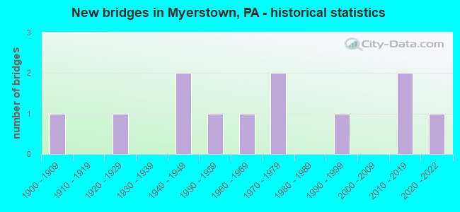
- New bridges - historical statistics
- 11900-1909
- 11920-1929
- 21940-1949
- 11950-1959
- 11960-1969
- 21970-1979
- 11990-1999
- 22010-2019
- 12020-2022


- Bridge Condition - Deck
- 12.5%Excellent
- 12.5%Good
- 25.0%Satisfactory
- 37.5%Fair
- 12.5%Poor

- Bridge Condition - Superstructure
- 9.1%Excellent
- 9.1%Very good
- 18.2%Good
- 9.1%Satisfactory
- 45.5%Fair
- 9.1%Poor

- Bridge Condition - Substructure
- 9.1%Excellent
- 18.2%Very good
- 27.3%Satisfactory
- 45.5%Fair

- Bridge Condition - Channel
- 9.1%Very good
- 27.3%Good
- 18.2%Satisfactory
- 45.5%Fair
Find on map >> Show street view
Structure Number: 2293, Location: PG14 PANGBURN HOLLOW #14 (Lat: 40.216756, Lng: -79.903533), Route carried "on" structure: County highway , Year Built: 1992, Status: Open, Structure Length: 0.73m (2.40ft), Average Daily Traffic: 700 (year 2020), Truck Traffic: 5%, Average Future Daily Traffic: 700 (year 2040), Design Load: HS 25 or greater, Features Intersected: PERRY MILL RUN TRIB, Facility Carried by Structure: PANGBURN HOLLOW RD
Minimum Vertical Clearance: 30+ m (98+ ft), Kilometerpoint: 0.000, Lanes on structure: 2, Owner: County Highway Agency, Approaching Roadway Width: 7.9m (25.9ft), Skew: 3 degrees, Material/Design: Concrete, Design/Construction: Culvert, Number Of Spans In Main Unit: 1, Length of Maximum Span: 7.3m (24.0ft)
Condition: Channel: Satisfactory, Culverts: Good, Operating Rating: 58.1 metric tons, Method Used To Determine Operating Rating: Load Factor (LF), Inventory Rating: 34.5 metric tons, Method Used To Determine Inventory Rating: Load Factor (LF), Structural Evaluation: Better than present minimum criteria, Waterway Adequacy: Equal to present desirable criteria, Approach Roadway Alignment: Equal to present desirable criteria, Length Of Structure Improvement: 0.70m (2.30ft), Designated Inspection Frequency: Every 24 months, Inspection Date: September 2020
Find on map >> Show street view
Structure Number: 22705, Location: 2mi E Myerstown (Lat: 40.383142, Lng: -76.287344), Route carried "on" structure: US 422, Year Built: 1947, Status: Open, Structure Length: 0.70m (2.30ft), Average Daily Traffic: 10,735 (year 2020), Truck Traffic: 7%, Average Future Daily Traffic: 18,310 (year 2032), Design Load: HS 20, Features Intersected: TRIB.OWL CREEK
Minimum Vertical Clearance: 30+ m (98+ ft), Kilometerpoint: 26.377, Lanes on structure: 2, Base Highway Network: Yes, Owner: State Highway Agency, Approaching Roadway Width: 14.9m (48.9ft), Skew: 3 degrees, Material/Design: Concrete, Design/Construction: Tee Beam, Number Of Spans In Main Unit: 1, Length of Maximum Span: 6.4m (21.0ft), Curb or Sidewalk Widths: Left: 0.2m (0.7ft), Right: 0.2m (0.7ft), Curb-To-Curb Width: 15.0m (49.2ft), Out-to-Out Width: 16.0m (52.5ft)
Condition: Deck: Fair, Superstructure: Fair, Substructure: Fair, Channel: Fair, Operating Rating: 51.7 metric tons, Method Used To Determine Operating Rating: Load Factor (LF), Inventory Rating: 30.8 metric tons, Method Used To Determine Inventory Rating: Load Factor (LF), Structural Evaluation: Somewhat better than minimum adequacy, Deck Geometry: Superior to present desirable criteria, Waterway Adequacy: Equal to present minimum criteria, Approach Roadway Alignment: Equal to present desirable criteria, Length Of Structure Improvement: 1.30m (4.27ft), Designated Inspection Frequency: Every 24 months, Inspection Date: June 2021, Bridge Improvement Cost: $25,000, Roadway Improvement Cost: $73,000, Total Project Cost: $335,000, Deck Structure Type: Concrete Cast-file-Place, Wearing Surface/Protective System: Wearing Surface: Bituminous
Find on map >> Show street view
Structure Number: 22719, Location: MYERSTOWN BOROUGH (Lat: 40.368367, Lng: -76.305542), Route carried "on" structure: State highway 501, Year Built: 1940, Year Reconstructed: 1968, Status: Open, Structure Length: 0.70m (2.30ft), Average Daily Traffic: 9,307 (year 2022), Truck Traffic: 13%, Average Future Daily Traffic: 11,165 (year 2032), Design Load: HS 20, Features Intersected: TULPEHOCKEN CREEK
Minimum Vertical Clearance: 30+ m (98+ ft), Kilometerpoint: 13.502, Lanes on structure: 2, Owner: State Highway Agency, Approaching Roadway Width: 10.4m (34.1ft), Material/Design: Concrete, Design/Construction: Slab, Number Of Spans In Main Unit: 1, Length of Maximum Span: 6.1m (20.0ft), Curb or Sidewalk Widths: Left: 2.0m (6.6ft), Right: 2.0m (6.6ft), Curb-To-Curb Width: 10.4m (34.1ft), Out-to-Out Width: 14.4m (47.2ft)
Condition: Deck: Poor, Superstructure: Poor, Substructure: Fair, Channel: Fair, Operating Rating: 59.0 metric tons, Method Used To Determine Operating Rating: Load Factor (LF), Inventory Rating: 35.4 metric tons, Method Used To Determine Inventory Rating: Load Factor (LF), Structural Evaluation: Meets minimum limits, Deck Geometry: Meets minimum limits, Waterway Adequacy: Equal to present minimum criteria, Approach Roadway Alignment: Equal to present desirable criteria, Length Of Structure Improvement: 1.30m (4.27ft), Designated Inspection Frequency: Every 24 months, Inspection Date: June 2021, Bridge Improvement Cost: $52,000, Roadway Improvement Cost: $154,000, Total Project Cost: $705,000, Wearing Surface/Protective System: Wearing Surface: Bituminous
Find on map >> Show street view
Structure Number: 2276, Location: 1 MI.S. MYERSTOWN (Lat: 40.365000, Lng: -76.291497), Route carried "on" structure: State highway , Year Built: 1955, Status: Open, Structure Length: 1.83m (6.00ft), Average Daily Traffic: 1,161 (year 2021), Truck Traffic: 7%, Average Future Daily Traffic: 2,414 (year 2032), Design Load: HS 20, Features Intersected: Norfolk Southern RR, Facility Carried by Structure: SR 2011
Minimum Vertical Clearance: 30+ m (98+ ft), Kilometerpoint: 3.676, Lanes on structure: 2, Owner: Railroad, Approaching Roadway Width: 8.2m (26.9ft), Material/Design: Steel, Design/Construction: Girder and Floorbeam System, Number Of Spans In Main Unit: 1, Length of Maximum Span: 17.1m (56.1ft), Curb or Sidewalk Widths: Left: 0.1m (0.3ft), Right: 0.1m (0.3ft), Curb-To-Curb Width: 7.3m (24.0ft), Out-to-Out Width: 8.3m (27.2ft)
Condition: Deck: Fair, Superstructure: Fair, Substructure: Fair, Operating Rating: 68.0 metric tons, Method Used To Determine Operating Rating: Load Factor (LF), Inventory Rating: 40.8 metric tons, Method Used To Determine Inventory Rating: Load Factor (LF), Structural Evaluation: Somewhat better than minimum adequacy, Deck Geometry: Meets minimum limits, Underclear: High priority of replacement, Approach Roadway Alignment: Equal to present desirable criteria, Length Of Structure Improvement: 2.50m (8.20ft), Designated Inspection Frequency: Every 24 months, Critical Feature Inspection Frequency: Every 24 months, Inspection Date: June 2021, Critical Feature Inspection Date: June 2021, Bridge Improvement Cost: $57,000, Roadway Improvement Cost: $167,000, Total Project Cost: $766,000, Deck Structure Type: Concrete Cast-file-Place, Wearing Surface/Protective System: Wearing Surface: Bituminous, Membrane: Preformed Fabric
Find on map >> Show street view
Structure Number: 22928, Location: MYERSTOWN/TULPEHOCKEN (Lat: 40.372928, Lng: -76.296781), Route carried "on" structure: City street , Year Built: 1900, Status: Open, Structure Length: 0.79m (2.59ft), Average Daily Traffic: 200 (year 2012), Truck Traffic: 10%, Average Future Daily Traffic: 600 (year 2032), Features Intersected: TULPEHOCKEN CREEK, Facility Carried by Structure: MILL AVE.
Minimum Vertical Clearance: 30+ m (98+ ft), Kilometerpoint: 0.000, Lanes on structure: 1, Owner: County Highway Agency, Approaching Roadway Width: 6.1m (20.0ft), Material/Design: Masonry, Design/Construction: Arch - Deck, Number Of Spans In Main Unit: 2, Length of Maximum Span: 3.4m (11.2ft), Curb-To-Curb Width: 4.8m (15.7ft), Out-to-Out Width: 6.2m (20.3ft)
Condition: Superstructure: Fair, Substructure: Fair, Channel: Satisfactory, Operating Rating: 49.0 metric tons, Method Used To Determine Operating Rating: Field evaluation and documented engineering judgment, Inventory Rating: 32.7 metric tons, Method Used To Determine Inventory Rating: Field evaluation and documented engineering judgment, Structural Evaluation: Somewhat better than minimum adequacy, Deck Geometry: High priority of corrective action, Waterway Adequacy: Equal to present minimum criteria, Approach Roadway Alignment: Equal to present desirable criteria, Length Of Structure Improvement: 0.90m (2.95ft), Designated Inspection Frequency: Every 24 months, Inspection Date: April 2020, Bridge Improvement Cost: $10,000, Roadway Improvement Cost: $61,000, Total Project Cost: $129,000
Find on map >> Show street view
Structure Number: 2293, Location: RICHLAND AVE/MAPLE AVE (Lat: 40.369319, Lng: -76.298608), Route carried "on" structure: City street , Year Built: 1964, Status: Posted for load, Structure Length: 1.01m (3.31ft), Average Daily Traffic: 200 (year 2013), Truck Traffic: 5%, Average Future Daily Traffic: 400 (year 2033), Design Load: HS 20, Features Intersected: TULPEHOCKEN CREEK, Facility Carried by Structure: BROAD STREET
Minimum Vertical Clearance: 30+ m (98+ ft), Kilometerpoint: 0.000, Lanes on structure: 2, Owner: City or Municipal Highway Agency, Approaching Roadway Width: 8.5m (27.9ft), Material/Design: Prestressed concrete, Design/Construction: Box Beam or Girders - Multiple, Number Of Spans In Main Unit: 1, Length of Maximum Span: 9.8m (32.2ft), Curb or Sidewalk Widths: Left: 0.4m (1.3ft), Right: 0.4m (1.3ft), Curb-To-Curb Width: 7.6m (24.9ft), Out-to-Out Width: 8.5m (27.9ft)
Condition: Deck: Fair, Superstructure: Fair, Substructure: Satisfactory, Channel: Fair, Operating Rating: 42.6 metric tons, Method Used To Determine Operating Rating: Load Factor (LF), Inventory Rating: 25.4 metric tons, Method Used To Determine Inventory Rating: Load Factor (LF), Structural Evaluation: Somewhat better than minimum adequacy, Deck Geometry: Somewhat better than minimum adequacy, Waterway Adequacy: Equal to present desirable criteria, Approach Roadway Alignment: Equal to present desirable criteria, Bridge Posting: Required (Relationship of Operating Rating to Maximum Legal Load: 0.1 - 9.9% below), Length Of Structure Improvement: 1.10m (3.61ft), Designated Inspection Frequency: Every 24 months, Other Special Inspection Frequency: Every 12 months, Inspection Date: May 2021, Other Special Inspection Date: May 2021, Bridge Improvement Cost: $4,000, Roadway Improvement Cost: $12,000, Total Project Cost: $54,000, Deck Structure Type: Other, Wearing Surface/Protective System: Wearing Surface: Bituminous
Find on map >> Show street view
Structure Number: 22931, Location: RICHLAND AND MAPLE AVE (Lat: 40.369828, Lng: -76.310044), Route carried "on" structure: City street , Year Built: 1974, Status: Open, Structure Length: 1.07m (3.51ft), Average Daily Traffic: 200 (year 2013), Truck Traffic: 5%, Average Future Daily Traffic: 2,800 (year 2033), Design Load: HS 20, Features Intersected: TULPEHOCKEN CREEK, Facility Carried by Structure: LOCUST STREET
Minimum Vertical Clearance: 30+ m (98+ ft), Kilometerpoint: 0.000, Lanes on structure: 2, Owner: City or Municipal Highway Agency, Approaching Roadway Width: 9.1m (29.9ft), Material/Design: Prestressed concrete, Design/Construction: Box Beam or Girders - Multiple, Number Of Spans In Main Unit: 1, Length of Maximum Span: 10.4m (34.1ft), Curb or Sidewalk Widths: Left: 0.2m (0.7ft), Right: 1.0m (3.3ft), Curb-To-Curb Width: 8.5m (27.9ft), Out-to-Out Width: 10.5m (34.4ft)
Condition: Deck: Satisfactory, Superstructure: Good, Substructure: Satisfactory, Channel: Good, Operating Rating: 75.3 metric tons, Method Used To Determine Operating Rating: Load Factor (LF), Inventory Rating: 45.4 metric tons, Method Used To Determine Inventory Rating: Load Factor (LF), Structural Evaluation: Equal to present minimum criteria, Deck Geometry: Equal to present minimum criteria, Waterway Adequacy: Equal to present desirable criteria, Approach Roadway Alignment: Equal to present desirable criteria, Length Of Structure Improvement: 1.80m (5.91ft), Designated Inspection Frequency: Every 24 months, Inspection Date: May 2021, Deck Structure Type: Concrete Cast-file-Place, Wearing Surface/Protective System: Wearing Surface: Monolithic Concrete
Find on map >> Show street view
Structure Number: 22932, Location: MUTH/CENTER TULPEHOCKEN (Lat: 40.369786, Lng: -76.300656), Route carried "on" structure: City street , Year Built: 1972, Status: Open, Structure Length: 1.04m (3.41ft), Average Daily Traffic: 200 (year 2013), Truck Traffic: 5%, Average Future Daily Traffic: 2,800 (year 2033), Design Load: HS 20, Features Intersected: TULPEHOCKEN CR., Facility Carried by Structure: CHERRY STREET
Minimum Vertical Clearance: 30+ m (98+ ft), Kilometerpoint: 0.000, Lanes on structure: 2, Owner: City or Municipal Highway Agency, Approaching Roadway Width: 7.3m (24.0ft), Skew: 1 degrees, Material/Design: Prestressed concrete, Design/Construction: Box Beam or Girders - Multiple, Number Of Spans In Main Unit: 1, Length of Maximum Span: 10.1m (33.1ft), Curb or Sidewalk Widths: Left: 0.2m (0.7ft), Right: 1.2m (3.9ft), Curb-To-Curb Width: 7.3m (24.0ft), Out-to-Out Width: 9.5m (31.2ft)
Condition: Deck: Satisfactory, Superstructure: Satisfactory, Substructure: Satisfactory, Channel: Fair, Operating Rating: 66.2 metric tons, Method Used To Determine Operating Rating: Load Factor (LF), Inventory Rating: 39.0 metric tons, Method Used To Determine Inventory Rating: Load Factor (LF), Structural Evaluation: Equal to present minimum criteria, Deck Geometry: Somewhat better than minimum adequacy, Waterway Adequacy: Equal to present desirable criteria, Approach Roadway Alignment: Equal to present desirable criteria, Length Of Structure Improvement: 1.70m (5.58ft), Designated Inspection Frequency: Every 24 months, Inspection Date: May 2021, Deck Structure Type: Concrete Cast-file-Place, Wearing Surface/Protective System: Wearing Surface: Monolithic Concrete
Find on map >> Show street view
Structure Number: 22933, Location: BETWEEN MUTH AND CENTER (Lat: 40.369289, Lng: -76.302536), Route carried "on" structure: City street , Year Built: 1920, Status: Open, Structure Length: 0.82m (2.69ft), Average Daily Traffic: 800 (year 2013), Truck Traffic: 10%, Average Future Daily Traffic: 3,290 (year 2033), Features Intersected: TULPEHOCKEN CREEK, Facility Carried by Structure: RAILROAD STREET
Minimum Vertical Clearance: 30+ m (98+ ft), Kilometerpoint: 0.000, Lanes on structure: 2, Owner: City or Municipal Highway Agency, Approaching Roadway Width: 9.8m (32.2ft), Material/Design: Masonry, Design/Construction: Arch - Deck, Number Of Spans In Main Unit: 2, Length of Maximum Span: 3.4m (11.2ft), Curb or Sidewalk Widths: Left: 0.2m (0.7ft), Right: 3.4m (11.2ft), Curb-To-Curb Width: 9.8m (32.2ft), Out-to-Out Width: 13.4m (44.0ft)
Condition: Superstructure: Fair, Substructure: Fair, Channel: Fair, Operating Rating: 49.0 metric tons, Method Used To Determine Operating Rating: Field evaluation and documented engineering judgment, Inventory Rating: 32.7 metric tons, Method Used To Determine Inventory Rating: Field evaluation and documented engineering judgment, Structural Evaluation: Somewhat better than minimum adequacy, Deck Geometry: Equal to present minimum criteria, Waterway Adequacy: Better than present minimum criteria, Approach Roadway Alignment: Equal to present desirable criteria, Length Of Structure Improvement: 1.50m (4.92ft), Designated Inspection Frequency: Every 24 months, Inspection Date: April 2021
Find on map >> Show street view
Structure Number: 52507, Location: W. Myerstown/ Tulpehocken (Lat: 40.366097, Lng: -76.323000), Route carried "on" structure: City street , Year Built: 2015, Status: Open, Structure Length: 0.79m (2.59ft), Average Daily Traffic: 500 (year 2015), Truck Traffic: 10%, Average Future Daily Traffic: 500 (year 2016), Design Load: HS 25 or greater, Features Intersected: Tulpehocken Creek, Facility Carried by Structure: Fairlane Avenue
Minimum Vertical Clearance: 30.18m (99.02ft), Kilometerpoint: 0.000, Lanes on structure: 2, Toll: Toll bridge, Owner: Town or Township Highway Agency, Approaching Roadway Width: 7.9m (25.9ft), Skew: 1 degrees, Material/Design: Concrete, Design/Construction: Arch - Deck, Number Of Spans In Main Unit: 1, Length of Maximum Span: 7.9m (25.9ft), Curb-To-Curb Width: 7.9m (25.9ft), Out-to-Out Width: 12.2m (40.0ft)
Condition: Superstructure: Very good, Substructure: Very good, Channel: Good, Operating Rating: 77.1 metric tons, Method Used To Determine Operating Rating: Assigned rating based on Load Factor Design (LFD) reported in metric tons, Inventory Rating: 50.8 metric tons, Method Used To Determine Inventory Rating: Assigned rating based on Load Factor Design (LFD) reported in metric tons, Structural Evaluation: Equal to present desirable criteria, Deck Geometry: Somewhat better than minimum adequacy, Waterway Adequacy: Better than present minimum criteria, Approach Roadway Alignment: Equal to present desirable criteria, Designated Inspection Frequency: Every 24 months, Inspection Date: March 2021
Find on map >> Show street view
Structure Number: 52901, Location: W. Myerstown/ Tulpehocken (Lat: 40.369489, Lng: -76.313281), Route carried "on" structure: City street /0, Year Built: 2013, Status: Open, Structure Length: 1.46m (4.79ft), Average Daily Traffic: 500 (year 2016), Truck Traffic: 5%, Average Future Daily Traffic: 600 (year 2036), Design Load: HS 25 or greater, Features Intersected: Tulpehocken Creek, Facility Carried by Structure: Race Street
Minimum Vertical Clearance: 30+ m (98+ ft), Kilometerpoint: 0.000, Lanes on structure: 2, Owner: Town or Township Highway Agency, Approaching Roadway Width: 7.3m (24.0ft), Material/Design: Steel, Design/Construction: Stringer/Multi-beam, Number Of Spans In Main Unit: 1, Length of Maximum Span: 13.7m (44.9ft), Curb-To-Curb Width: 7.3m (24.0ft), Out-to-Out Width: 7.3m (24.0ft)
Condition: Deck: Good, Superstructure: Good, Substructure: Very good, Channel: Very good, Operating Rating: 76.2 metric tons, Method Used To Determine Operating Rating: Assigned rating based on Load Factor Design (LFD) reported in metric tons, Inventory Rating: 45.4 metric tons, Method Used To Determine Inventory Rating: Assigned rating based on Load Factor Design (LFD) reported in metric tons, Structural Evaluation: Better than present minimum criteria, Deck Geometry: Meets minimum limits, Waterway Adequacy: Better than present minimum criteria, Approach Roadway Alignment: Equal to present minimum criteria, Designated Inspection Frequency: Every 24 months, Inspection Date: March 2021, Deck Structure Type: Corrugated Steel, Wearing Surface/Protective System: Wearing Surface: Bituminous
Find on map >> Show street view
Structure Number: 68336, Location: 2 MI.W. OF MYERSTOWN (Lat: 40.367092, Lng: -76.338889), Route carried "on" structure: US 422, Year Built: 2021, Status: Open, Structure Length: 1.31m (4.30ft), Average Daily Traffic: 7,216 (year 2022), Truck Traffic: 7%, Average Future Daily Traffic: 10,094 (year 2032), Design Load: HL 93, Features Intersected: Trib. Tulpehocken Creek
Minimum Vertical Clearance: 30+ m (98+ ft), Kilometerpoint: 21.525, Lanes on structure: 3, Base Highway Network: Yes, Owner: State Highway Agency, Approaching Roadway Width: 16.5m (54.1ft), Skew: 21 degrees, Material/Design: Prestressed concrete, Design/Construction: Box Beam or Girders - Single/Spread, Number Of Spans In Main Unit: 1, Length of Maximum Span: 12.2m (40.0ft), Curb or Sidewalk Widths: Left: 0.2m (0.7ft), Right: 0.2m (0.7ft), Curb-To-Curb Width: 15.5m (50.9ft), Out-to-Out Width: 16.6m (54.5ft)
Condition: Deck: Excellent, Superstructure: Excellent, Substructure: Excellent, Channel: Good, Operating Rating: 46.0 metric tons, Method Used To Determine Operating Rating: Assigned ratings based on Load and Resistance Factor Design (LRFD) reported by rating factor (RF) using HL93 loadings, Inventory Rating: 35.6 metric tons, Method Used To Determine Inventory Rating: Assigned ratings based on Load and Resistance Factor Design (LRFD) reported by rating factor (RF) using HL93 loadings, Structural Evaluation: Superior to present desirable criteria, Deck Geometry: Equal to present minimum criteria, Waterway Adequacy: Better than present minimum criteria, Approach Roadway Alignment: Equal to present desirable criteria, Designated Inspection Frequency: Every 24 months, Inspection Date: July 2021, Deck Structure Type: Concrete Cast-file-Place, Wearing Surface/Protective System: Wearing Surface: Monolithic Concrete, Membrane: Preformed Fabric, Deck Protection: Epoxy Coated Reinforcing