Bridge Statistics for Myrtle Springs, Texas (TX)
Condition, Traffic, Stress, Structural Evaluation, Project Costs
- National Bridge Inventory (NBI) Statistics
- 24Number of bridges
- 164ft / 49.7mTotal length
- $4,000Total costs
- 325,073Total average daily traffic
- 77,698Total average daily truck traffic
- National Bridge Inventory (NBI) Registered Bridges for Myrtle Springs
- No street view available for this location
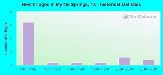
- New bridges - historical statistics
- 161960-1969
- 11970-1979
- 11980-1989
- 11990-1999
- 32000-2009
- 22010-2019


- Bridge Condition - Deck
- 10.0%Very good
- 50.0%Good
- 40.0%Satisfactory

- Bridge Condition - Superstructure
- 20.0%Very good
- 40.0%Good
- 30.0%Satisfactory
- 10.0%Fair

- Bridge Condition - Substructure
- 10.0%Very good
- 50.0%Good
- 30.0%Satisfactory
- 10.0%Fair

- Bridge Condition - Channel
- 43.8%Good
- 50.0%Satisfactory
- 6.3%Fair

- Bridge Condition - Culverts
- 20.0%Good
- 80.0%Satisfactory
Find on map >> Show street view
Structure Number: 102340049502019, Location: 4.63 MI E OF KAUFMAN C/L (Lat: 32.625500, Lng: -96.002406), Route carried "on" structure: Interstate 20, Year Built: 1963, Status: Open, Structure Length: 0.64m (2.10ft), Average Daily Traffic: 43,616 (year 2020), Truck Traffic: 24%, Average Future Daily Traffic: 51,480 (year 2033), Design Load: HS 20, Features Intersected: FLAT CRK TR
Minimum Vertical Clearance: 30+ m (98+ ft), Kilometerpoint: 7.458, Lanes on structure: 4, Base Highway Network: Yes, Owner: State Highway Agency, Approaching Roadway Width: 23.5m (77.1ft), Skew: 30 degrees, Material/Design: Concrete, Design/Construction: Culvert, Number Of Spans In Main Unit: 2, Length of Maximum Span: 3.0m (9.8ft)
Condition: Channel: Good, Culverts: Satisfactory, Operating Rating: 39.9 metric tons, Method Used To Determine Operating Rating: Load Factor (LF), Inventory Rating: 23.6 metric tons, Method Used To Determine Inventory Rating: Load Factor (LF), Structural Evaluation: Somewhat better than minimum adequacy, Waterway Adequacy: Superior to present desirable criteria, Approach Roadway Alignment: Equal to present desirable criteria, Designated Inspection Frequency: Every 24 months, Inspection Date: October 2020, Deck Structure Type: Concrete Cast-file-Place, Wearing Surface/Protective System: Wearing Surface: Bituminous
Find on map >> Show street view
Structure Number: 10234004950202, Location: 4.63 MI E OF KAUFMAN C/L (Lat: 32.625992, Lng: -96.002186), Route carried "on" structure: ServiceState highway 20, Year Built: 1963, Status: Open, Structure Length: 0.64m (2.10ft), Average Daily Traffic: 620 (year 2013), Truck Traffic: 24%, Average Future Daily Traffic: 870 (year 2033), Design Load: HS 20, Features Intersected: FLAT CRK TR
Minimum Vertical Clearance: 30+ m (98+ ft), Kilometerpoint: 7.458, Lanes on structure: 2, Owner: State Highway Agency, Approaching Roadway Width: 6.1m (20.0ft), Material/Design: Concrete, Design/Construction: Culvert, Number Of Spans In Main Unit: 2, Length of Maximum Span: 3.0m (9.8ft)
Condition: Channel: Good, Culverts: Good, Operating Rating: 39.9 metric tons, Method Used To Determine Operating Rating: Load Factor (LF), Inventory Rating: 23.6 metric tons, Method Used To Determine Inventory Rating: Load Factor (LF), Structural Evaluation: Equal to present minimum criteria, Waterway Adequacy: Better than present minimum criteria, Approach Roadway Alignment: Equal to present desirable criteria, Designated Inspection Frequency: Every 24 months, Inspection Date: October 2020
Find on map >> Show street view
Structure Number: 102340049502021, Location: 4.63 MI E OF KAUFMAN C/L (Lat: 32.625297, Lng: -96.002503), Route carried "on" structure: ServiceState highway 20, Year Built: 1963, Status: Open, Structure Length: 0.64m (2.10ft), Average Daily Traffic: 470 (year 2013), Truck Traffic: 24%, Average Future Daily Traffic: 670 (year 2033), Design Load: HS 20, Features Intersected: FLAT CRK TR
Minimum Vertical Clearance: 30+ m (98+ ft), Kilometerpoint: 7.458, Lanes on structure: 2, Owner: State Highway Agency, Approaching Roadway Width: 6.1m (20.0ft), Material/Design: Concrete, Design/Construction: Culvert, Number Of Spans In Main Unit: 2, Length of Maximum Span: 3.0m (9.8ft)
Condition: Channel: Good, Culverts: Satisfactory, Operating Rating: 39.9 metric tons, Method Used To Determine Operating Rating: Load Factor (LF), Inventory Rating: 23.6 metric tons, Method Used To Determine Inventory Rating: Load Factor (LF), Structural Evaluation: Equal to present minimum criteria, Waterway Adequacy: Better than present minimum criteria, Approach Roadway Alignment: Equal to present desirable criteria, Designated Inspection Frequency: Every 24 months, Inspection Date: October 2020
Find on map >> Show street view
Structure Number: 102340049502022, Location: 1.56 MI E OF FM 47 (Lat: 32.623694, Lng: -95.997319), Route carried "on" structure: County highway 3416, Year Built: 1963, Status: Open, Structure Length: 7.68m (25.20ft), Average Daily Traffic: 50 (year 2010), Truck Traffic: 5%, Average Future Daily Traffic: 100 (year 2030), Design Load: H 15, Features Intersected: IH 20
Minimum Vertical Clearance: 30+ m (98+ ft), Kilometerpoint: 0.805, Lanes on structure: 2, Lanes under structure: 4, Owner: State Highway Agency, Approaching Roadway Width: 7.0m (23.0ft), Skew: 3 degrees, Material/Design: Steel continuous, Design/Construction: Stringer/Multi-beam, Number Of Spans In Main Unit: 4, Length of Maximum Span: 21.3m (69.9ft), Curb-To-Curb Width: 7.1m (23.3ft), Out-to-Out Width: 7.8m (25.6ft)
Condition: Deck: Satisfactory, Superstructure: Satisfactory, Substructure: Good, Operating Rating: 44.4 metric tons, Method Used To Determine Operating Rating: Load Factor (LF), Inventory Rating: 27.2 metric tons, Method Used To Determine Inventory Rating: Load Factor (LF), Structural Evaluation: Equal to present minimum criteria, Deck Geometry: Somewhat better than minimum adequacy, Underclear: Meets minimum limits, Approach Roadway Alignment: Equal to present desirable criteria, Designated Inspection Frequency: Every 24 months, Inspection Date: October 2020, Deck Structure Type: Concrete Cast-file-Place, Wearing Surface/Protective System: Wearing Surface: Bituminous
Find on map >> Show street view
Structure Number: 102340049502023, Location: 1.78 MI E OF FM 47 (Lat: 32.622656, Lng: -95.993922), Route carried "on" structure: Interstate 20, Year Built: 1963, Status: Open, Structure Length: 0.94m (3.08ft), Average Daily Traffic: 43,616 (year 2020), Truck Traffic: 24%, Average Future Daily Traffic: 51,480 (year 2033), Design Load: HS 20, Features Intersected: ANDY BR FLAT CRK
Minimum Vertical Clearance: 30+ m (98+ ft), Kilometerpoint: 8.315, Lanes on structure: 4, Base Highway Network: Yes, Owner: State Highway Agency, Approaching Roadway Width: 23.5m (77.1ft), Skew: 30 degrees, Material/Design: Concrete, Design/Construction: Culvert, Number Of Spans In Main Unit: 3, Length of Maximum Span: 3.0m (9.8ft)
Condition: Channel: Satisfactory, Culverts: Satisfactory, Operating Rating: 39.9 metric tons, Method Used To Determine Operating Rating: Load Factor (LF), Inventory Rating: 23.6 metric tons, Method Used To Determine Inventory Rating: Load Factor (LF), Structural Evaluation: Somewhat better than minimum adequacy, Waterway Adequacy: Superior to present desirable criteria, Approach Roadway Alignment: Equal to present desirable criteria, Designated Inspection Frequency: Every 24 months, Inspection Date: October 2020, Deck Structure Type: Concrete Cast-file-Place, Wearing Surface/Protective System: Wearing Surface: Bituminous
Find on map >> Show street view
Structure Number: 102340049502024, Location: 2.68 MI E OF FM 47 (Lat: 32.617753, Lng: -95.979631), Route carried "on" structure: County highway 3412, Year Built: 1963, Status: Open, Structure Length: 6.89m (22.60ft), Average Daily Traffic: 100 (year 2010), Truck Traffic: 5%, Average Future Daily Traffic: 200 (year 2030), Design Load: H 15, Features Intersected: IH 20
Minimum Vertical Clearance: 30+ m (98+ ft), Kilometerpoint: 0.805, Lanes on structure: 2, Lanes under structure: 4, Owner: State Highway Agency, Approaching Roadway Width: 7.3m (24.0ft), Skew: 1 degrees, Material/Design: Steel continuous, Design/Construction: Stringer/Multi-beam, Number Of Spans In Main Unit: 4, Length of Maximum Span: 18.9m (62.0ft), Curb-To-Curb Width: 7.1m (23.3ft), Out-to-Out Width: 7.8m (25.6ft)
Condition: Deck: Satisfactory, Superstructure: Good, Substructure: Satisfactory, Operating Rating: 44.4 metric tons, Method Used To Determine Operating Rating: Load Factor (LF), Inventory Rating: 26.3 metric tons, Method Used To Determine Inventory Rating: Load Factor (LF), Structural Evaluation: Equal to present minimum criteria, Deck Geometry: Somewhat better than minimum adequacy, Underclear: Meets minimum limits, Approach Roadway Alignment: Equal to present desirable criteria, Designated Inspection Frequency: Every 24 months, Inspection Date: October 2020, Deck Structure Type: Concrete Cast-file-Place, Wearing Surface/Protective System: Wearing Surface: Bituminous
Find on map >> Show street view
Structure Number: 102340049502025, Location: 2.73 MI E OF FM 47 (Lat: 32.616214, Lng: -95.978828), Route carried "on" structure: ServiceState highway 20, Year Built: 1963, Status: Open, Structure Length: 1.92m (6.30ft), Average Daily Traffic: 470 (year 2013), Truck Traffic: 24%, Average Future Daily Traffic: 670 (year 2033), Design Load: HS 20, Features Intersected: FLAT CREEK
Minimum Vertical Clearance: 30+ m (98+ ft), Kilometerpoint: 9.844, Lanes on structure: 2, Owner: State Highway Agency, Approaching Roadway Width: 8.5m (27.9ft), Material/Design: Concrete, Design/Construction: Culvert, Number Of Spans In Main Unit: 6, Length of Maximum Span: 3.0m (9.8ft), Curb-To-Curb Width: 8.6m (28.2ft), Out-to-Out Width: 12.0m (39.4ft)
Condition: Channel: Satisfactory, Culverts: Satisfactory, Operating Rating: 39.9 metric tons, Method Used To Determine Operating Rating: Load Factor (LF), Inventory Rating: 23.6 metric tons, Method Used To Determine Inventory Rating: Load Factor (LF), Structural Evaluation: Equal to present minimum criteria, Deck Geometry: Somewhat better than minimum adequacy, Waterway Adequacy: Better than present minimum criteria, Approach Roadway Alignment: Better than present minimum criteria, Designated Inspection Frequency: Every 24 months, Inspection Date: October 2020, Deck Structure Type: Concrete Cast-file-Place, Wearing Surface/Protective System: Wearing Surface: Bituminous
Find on map >> Show street view
Structure Number: 102340049502026, Location: 2.81 MI E OF FM 47 (Lat: 32.617175, Lng: -95.977500), Route carried "on" structure: Interstate 20, Year Built: 1963, Status: Open, Structure Length: 1.95m (6.40ft), Average Daily Traffic: 43,616 (year 2020), Truck Traffic: 24%, Average Future Daily Traffic: 51,480 (year 2033), Design Load: HS 20, Features Intersected: FLAT CREEK
Minimum Vertical Clearance: 30+ m (98+ ft), Kilometerpoint: 9.971, Lanes on structure: 4, Base Highway Network: Yes, Owner: State Highway Agency, Approaching Roadway Width: 23.5m (77.1ft), Skew: 30 degrees, Material/Design: Concrete, Design/Construction: Culvert, Number Of Spans In Main Unit: 6, Length of Maximum Span: 3.0m (9.8ft)
Condition: Channel: Good, Culverts: Satisfactory, Operating Rating: 39.9 metric tons, Method Used To Determine Operating Rating: Load Factor (LF), Inventory Rating: 23.6 metric tons, Method Used To Determine Inventory Rating: Load Factor (LF), Structural Evaluation: Somewhat better than minimum adequacy, Waterway Adequacy: Superior to present desirable criteria, Approach Roadway Alignment: Equal to present desirable criteria, Designated Inspection Frequency: Every 24 months, Inspection Date: October 2020, Deck Structure Type: Concrete Cast-file-Place, Wearing Surface/Protective System: Wearing Surface: Bituminous
Find on map >> Show street view
Structure Number: 102340049502027, Location: 2.81 MI E OF FM 47 (Lat: 32.617675, Lng: -95.977186), Route carried "on" structure: ServiceState highway 20, Year Built: 1963, Status: Open, Structure Length: 1.92m (6.30ft), Average Daily Traffic: 620 (year 2013), Truck Traffic: 24%, Average Future Daily Traffic: 870 (year 2033), Design Load: HS 20, Features Intersected: FLAT CREEK
Minimum Vertical Clearance: 30+ m (98+ ft), Kilometerpoint: 9.978, Lanes on structure: 2, Owner: State Highway Agency, Approaching Roadway Width: 8.5m (27.9ft), Material/Design: Concrete, Design/Construction: Culvert, Number Of Spans In Main Unit: 6, Length of Maximum Span: 3.0m (9.8ft), Curb-To-Curb Width: 8.6m (28.2ft), Out-to-Out Width: 13.2m (43.3ft)
Condition: Channel: Satisfactory, Culverts: Satisfactory, Operating Rating: 39.9 metric tons, Method Used To Determine Operating Rating: Load Factor (LF), Inventory Rating: 23.6 metric tons, Method Used To Determine Inventory Rating: Load Factor (LF), Structural Evaluation: Equal to present minimum criteria, Deck Geometry: Somewhat better than minimum adequacy, Waterway Adequacy: Better than present minimum criteria, Approach Roadway Alignment: Better than present minimum criteria, Designated Inspection Frequency: Every 24 months, Inspection Date: October 2020, Deck Structure Type: Concrete Cast-file-Place, Wearing Surface/Protective System: Wearing Surface: Bituminous
Find on map >> Show street view
Structure Number: 102340049502028, Location: 1.84 MI W OF SH 64 (Lat: 32.607394, Lng: -95.950744), Route carried "on" structure: County highway 3439, Year Built: 1963, Status: Open, Structure Length: 7.19m (23.59ft), Average Daily Traffic: 50 (year 2010), Truck Traffic: 5%, Average Future Daily Traffic: 100 (year 2030), Design Load: H 15, Features Intersected: IH 20
Minimum Vertical Clearance: 30+ m (98+ ft), Kilometerpoint: 0.805, Lanes on structure: 2, Lanes under structure: 4, Owner: State Highway Agency, Approaching Roadway Width: 7.3m (24.0ft), Skew: 2 degrees, Material/Design: Steel continuous, Design/Construction: Stringer/Multi-beam, Number Of Spans In Main Unit: 4, Length of Maximum Span: 19.8m (65.0ft), Curb-To-Curb Width: 7.1m (23.3ft), Out-to-Out Width: 7.8m (25.6ft)
Condition: Deck: Good, Superstructure: Satisfactory, Substructure: Good, Operating Rating: 41.7 metric tons, Method Used To Determine Operating Rating: Load Factor (LF), Inventory Rating: 24.5 metric tons, Method Used To Determine Inventory Rating: Load Factor (LF), Structural Evaluation: Equal to present minimum criteria, Deck Geometry: Somewhat better than minimum adequacy, Underclear: Somewhat better than minimum adequacy, Approach Roadway Alignment: Equal to present desirable criteria, Designated Inspection Frequency: Every 24 months, Inspection Date: October 2020, Deck Structure Type: Concrete Cast-file-Place, Wearing Surface/Protective System: Wearing Surface: Bituminous
Find on map >> Show street view
Structure Number: 102340049502029, Location: 1.22 MI W OF SH 64 (Lat: 32.603564, Lng: -95.941297), Route carried "on" structure: County highway 3442, Year Built: 1963, Status: Open, Structure Length: 6.77m (22.21ft), Average Daily Traffic: 100 (year 2010), Truck Traffic: 5%, Average Future Daily Traffic: 200 (year 2030), Design Load: H 15, Features Intersected: IH 20
Minimum Vertical Clearance: 30+ m (98+ ft), Kilometerpoint: 0.805, Lanes on structure: 2, Lanes under structure: 4, Owner: State Highway Agency, Approaching Roadway Width: 7.3m (24.0ft), Skew: 1 degrees, Material/Design: Steel continuous, Design/Construction: Stringer/Multi-beam, Number Of Spans In Main Unit: 4, Length of Maximum Span: 18.3m (60.0ft), Curb-To-Curb Width: 7.1m (23.3ft), Out-to-Out Width: 7.8m (25.6ft)
Condition: Deck: Good, Superstructure: Good, Substructure: Good, Operating Rating: 38.1 metric tons, Method Used To Determine Operating Rating: Load Factor (LF), Inventory Rating: 22.7 metric tons, Method Used To Determine Inventory Rating: Load Factor (LF), Structural Evaluation: Equal to present minimum criteria, Deck Geometry: Somewhat better than minimum adequacy, Underclear: Somewhat better than minimum adequacy, Approach Roadway Alignment: Equal to present desirable criteria, Designated Inspection Frequency: Every 24 months, Inspection Date: October 2020, Deck Structure Type: Concrete Cast-file-Place, Wearing Surface/Protective System: Wearing Surface: Bituminous
Find on map >> Show street view
Structure Number: 102340049502031, Location: 0.51 MI W OF SH 64 (Lat: 32.599581, Lng: -95.930156), Route carried "on" structure: Interstate 20, Year Built: 1963, Year Reconstructed: 2002, Status: Open, Structure Length: 1.49m (4.89ft), Average Daily Traffic: 43,616 (year 2020), Truck Traffic: 24%, Average Future Daily Traffic: 51,480 (year 2033), Design Load: HS 20, Features Intersected: RATS BRANCH
Minimum Vertical Clearance: 30+ m (98+ ft), Kilometerpoint: 14.738, Lanes on structure: 8, Owner: State Highway Agency, Approaching Roadway Width: 38.1m (125.0ft), Skew: 33 degrees, Material/Design: Concrete, Design/Construction: Culvert, Number Of Spans In Main Unit: 4, Length of Maximum Span: 3.0m (9.8ft)
Condition: Channel: Fair, Culverts: Satisfactory, Operating Rating: 39.9 metric tons, Method Used To Determine Operating Rating: Load Factor (LF), Inventory Rating: 23.6 metric tons, Method Used To Determine Inventory Rating: Load Factor (LF), Structural Evaluation: Somewhat better than minimum adequacy, Waterway Adequacy: Superior to present desirable criteria, Approach Roadway Alignment: Equal to present desirable criteria, Designated Inspection Frequency: Every 24 months, Inspection Date: October 2020
Find on map >> Show street view
Structure Number: 102340AA2112002, Location: 0.15 MI S OF IH 20 (Lat: 32.615508, Lng: -95.979733), Route carried "on" structure: County highway 2112, Year Built: 2005, Status: Open, Structure Length: 0.98m (3.22ft), Average Daily Traffic: 270 (year 2015), Average Future Daily Traffic: 250 (year 2035), Design Load: HS 20, Features Intersected: FLAT CREEK
Minimum Vertical Clearance: 30+ m (98+ ft), Kilometerpoint: 5.794, Lanes on structure: 2, Owner: County Highway Agency, Approaching Roadway Width: 4.9m (16.1ft), Material/Design: Concrete, Design/Construction: Culvert, Number Of Spans In Main Unit: 3, Length of Maximum Span: 3.0m (9.8ft), Curb-To-Curb Width: 7.2m (23.6ft), Out-to-Out Width: 7.9m (25.9ft)
Condition: Channel: Satisfactory, Culverts: Good, Operating Rating: 54.4 metric tons, Method Used To Determine Operating Rating: Assigned rating based on Load Factor Design (LFD) reported in metric tons, Inventory Rating: 32.7 metric tons, Method Used To Determine Inventory Rating: Assigned rating based on Load Factor Design (LFD) reported in metric tons, Structural Evaluation: Better than present minimum criteria, Deck Geometry: Meets minimum limits, Waterway Adequacy: Better than present minimum criteria, Approach Roadway Alignment: Equal to present desirable criteria, Designated Inspection Frequency: Every 24 months, Inspection Date: October 2021, Deck Structure Type: Concrete Cast-file-Place, Wearing Surface/Protective System: Wearing Surface: Bituminous
Find on map >> Show street view
Structure Number: 102340AA2112101, Location: 3.00 Mi S of IH 20 (Lat: 32.575569, Lng: -95.986481), Route carried "on" structure: County highway 2112, Year Built: 1992, Status: Posted for load, Structure Length: 1.55m (5.09ft), Average Daily Traffic: 80 (year 2015), Average Future Daily Traffic: 50 (year 2035), Features Intersected: Caney Creek
Minimum Vertical Clearance: 30+ m (98+ ft), Kilometerpoint: 1.046, Lanes on structure: 1, Owner: County Highway Agency, Approaching Roadway Width: 4.9m (16.1ft), Material/Design: Wood or Timber, Design/Construction: Stringer/Multi-beam, Number Of Spans In Main Unit: 2, Length of Maximum Span: 7.6m (24.9ft), Curb-To-Curb Width: 4.9m (16.1ft), Out-to-Out Width: 4.9m (16.1ft)
Condition: Deck: Satisfactory, Superstructure: Fair, Substructure: Fair, Channel: Satisfactory, Operating Rating: 20.0 metric tons, Method Used To Determine Operating Rating: Allowable Stress (AS), Inventory Rating: 11.8 metric tons, Method Used To Determine Inventory Rating: Allowable Stress (AS), Structural Evaluation: Meets minimum limits, Deck Geometry: High priority of corrective action, Waterway Adequacy: Meets minimum limits, Approach Roadway Alignment: Equal to present minimum criteria, Bridge Posting: Required (Relationship of Operating Rating to Maximum Legal Load: > 39.9% below), Length Of Structure Improvement: 1.55m (5.09ft), Designated Inspection Frequency: Every 24 months, Inspection Date: October 2021, Bridge Improvement Cost: $2,000, Roadway Improvement Cost: $1,000, Total Project Cost: $3,000, Deck Structure Type: Wood or Timber, Wearing Surface/Protective System: Wearing Surface: Bituminous
Find on map >> Show street view
Structure Number: 102340AA2128101, Location: 1.15 MI E OF FM 47 (Lat: 32.597700, Lng: -96.003783), Route carried "on" structure: County highway 2128, Year Built: 1984, Status: Open, Structure Length: 0.76m (2.49ft), Average Daily Traffic: 30 (year 2009), Average Future Daily Traffic: 30 (year 2027), Features Intersected: FLAT CREEK
Minimum Vertical Clearance: 30+ m (98+ ft), Kilometerpoint: 0.563, Lanes on structure: 1, Owner: County Highway Agency, Approaching Roadway Width: 4.3m (14.1ft), Skew: 1 degrees, Material/Design: Wood or Timber, Design/Construction: Stringer/Multi-beam, Number Of Spans In Main Unit: 1, Length of Maximum Span: 7.3m (24.0ft), Curb-To-Curb Width: 4.8m (15.7ft), Out-to-Out Width: 4.8m (15.7ft)
Condition: Deck: Satisfactory, Superstructure: Satisfactory, Substructure: Satisfactory, Channel: Satisfactory, Operating Rating: 43.5 metric tons, Method Used To Determine Operating Rating: Allowable Stress (AS), Inventory Rating: 30.8 metric tons, Method Used To Determine Inventory Rating: Allowable Stress (AS), Structural Evaluation: Equal to present minimum criteria, Deck Geometry: Equal to present desirable criteria, Waterway Adequacy: Meets minimum limits, Approach Roadway Alignment: Equal to present desirable criteria, Designated Inspection Frequency: Every 24 months, Inspection Date: October 2021, Deck Structure Type: Wood or Timber, Wearing Surface/Protective System: Wearing Surface: Wood or Timber
Find on map >> Show street view
Structure Number: 102340AA2129001, Location: 1.4 MI S. of IH 20 (Lat: 32.603497, Lng: -95.997289), Route carried "on" structure: County highway 2129, Year Built: 2014, Status: Open, Structure Length: 1.52m (4.99ft), Average Daily Traffic: 40 (year 2015), Average Future Daily Traffic: 60 (year 2035), Design Load: HL 93, Features Intersected: Flat Creek
Minimum Vertical Clearance: 30+ m (98+ ft), Kilometerpoint: 5.150, Lanes on structure: 2, Owner: County Highway Agency, Approaching Roadway Width: 7.3m (24.0ft), Skew: 3 degrees, Material/Design: Prestressed concrete, Design/Construction: Slab, Number Of Spans In Main Unit: 1, Length of Maximum Span: 15.2m (49.9ft), Curb-To-Curb Width: 7.3m (24.0ft), Out-to-Out Width: 7.9m (25.9ft)
Condition: Deck: Good, Superstructure: Very good, Substructure: Good, Channel: Good, Operating Rating: 54.4 metric tons, Method Used To Determine Operating Rating: Assigned ratings based on Load and Resistance Factor Design (LRFD) reported in metric tons, Inventory Rating: 32.7 metric tons, Method Used To Determine Inventory Rating: Assigned ratings based on Load and Resistance Factor Design (LRFD) reported in metric tons, Structural Evaluation: Better than present minimum criteria, Deck Geometry: Equal to present minimum criteria, Waterway Adequacy: Better than present minimum criteria, Approach Roadway Alignment: Meets minimum limits, Designated Inspection Frequency: Every 24 months, Inspection Date: October 2021, Deck Structure Type: Concrete Cast-file-Place
Find on map >> Show street view
Structure Number: 102340AA2139101, Location: 2.00 MI S OF IH 20 (Lat: 32.578808, Lng: -95.962097), Route carried "on" structure: County highway 2139, Year Built: 2003, Status: Open, Structure Length: 0.76m (2.49ft), Average Daily Traffic: 80 (year 2009), Average Future Daily Traffic: 50 (year 2028), Features Intersected: CANEY CREEK
Minimum Vertical Clearance: 30+ m (98+ ft), Kilometerpoint: 0.217, Lanes on structure: 2, Owner: County Highway Agency, Approaching Roadway Width: 4.3m (14.1ft), Material/Design: Steel, Design/Construction: Stringer/Multi-beam, Number Of Spans In Main Unit: 1, Length of Maximum Span: 7.3m (24.0ft), Curb-To-Curb Width: 7.1m (23.3ft), Out-to-Out Width: 7.3m (24.0ft)
Condition: Deck: Good, Superstructure: Good, Substructure: Satisfactory, Channel: Satisfactory, Operating Rating: 46.3 metric tons, Method Used To Determine Operating Rating: Allowable Stress (AS), Inventory Rating: 35.4 metric tons, Method Used To Determine Inventory Rating: Allowable Stress (AS), Structural Evaluation: Equal to present minimum criteria, Deck Geometry: Somewhat better than minimum adequacy, Waterway Adequacy: Better than present minimum criteria, Approach Roadway Alignment: Equal to present desirable criteria, Designated Inspection Frequency: Every 24 months, Inspection Date: October 2021, Deck Structure Type: Concrete Cast-file-Place, Wearing Surface/Protective System: Wearing Surface: Bituminous
Find on map >> Show street view
Structure Number: 102340AA2142001, Location: 1.35 Mi S of IH 20 (Lat: 32.583467, Lng: -95.943881), Route carried "on" structure: County highway 2142, Year Built: 2019, Status: Open, Structure Length: 1.98m (6.50ft), Average Daily Traffic: 90 (year 2015), Average Future Daily Traffic: 1 (year 1900), Design Load: HL 93, Features Intersected: Caney Cr
Minimum Vertical Clearance: 30+ m (98+ ft), Kilometerpoint: 2.173, Lanes on structure: 2, Owner: County Highway Agency, Approaching Roadway Width: 4.9m (16.1ft), Material/Design: Prestressed concrete, Design/Construction: Box Beam or Girders - Multiple, Number Of Spans In Main Unit: 1, Length of Maximum Span: 19.8m (65.0ft), Curb-To-Curb Width: 7.3m (24.0ft), Out-to-Out Width: 8.0m (26.2ft)
Condition: Deck: Very good, Superstructure: Very good, Substructure: Very good, Channel: Good, Operating Rating: 54.4 metric tons, Method Used To Determine Operating Rating: Assigned ratings based on Load and Resistance Factor Design (LRFD) reported in metric tons, Inventory Rating: 32.7 metric tons, Method Used To Determine Inventory Rating: Assigned ratings based on Load and Resistance Factor Design (LRFD) reported in metric tons, Structural Evaluation: Equal to present desirable criteria, Deck Geometry: Equal to present minimum criteria, Waterway Adequacy: Equal to present minimum criteria, Approach Roadway Alignment: Equal to present desirable criteria, Designated Inspection Frequency: Every 24 months, Inspection Date: September 2021, Deck Structure Type: Concrete Cast-file-Place
Find on map >> Show street view
Structure Number: 102340AA2501002, Location: 0.50 MI S OF SH 243 (Lat: 32.539856, Lng: -95.941725), Route carried "on" structure: County highway 2501, Year Built: 2003, Status: Open, Structure Length: 2.77m (9.09ft), Average Daily Traffic: 320 (year 2015), Average Future Daily Traffic: 300 (year 2035), Design Load: HS 20, Features Intersected: DRY LACY FORK
Minimum Vertical Clearance: 30+ m (98+ ft), Kilometerpoint: 3.380, Lanes on structure: 2, Owner: County Highway Agency, Approaching Roadway Width: 4.9m (16.1ft), Material/Design: Concrete, Design/Construction: Stringer/Multi-beam, Number Of Spans In Main Unit: 3, Length of Maximum Span: 9.1m (29.9ft), Curb-To-Curb Width: 8.4m (27.6ft), Out-to-Out Width: 9.1m (29.9ft)
Condition: Deck: Good, Superstructure: Good, Substructure: Good, Channel: Good, Operating Rating: 68.0 metric tons, Method Used To Determine Operating Rating: Load Factor (LF), Inventory Rating: 40.8 metric tons, Method Used To Determine Inventory Rating: Load Factor (LF), Structural Evaluation: Better than present minimum criteria, Deck Geometry: Somewhat better than minimum adequacy, Waterway Adequacy: Better than present minimum criteria, Approach Roadway Alignment: Equal to present desirable criteria, Designated Inspection Frequency: Every 24 months, Inspection Date: October 2021, Deck Structure Type: Concrete Cast-file-Place
Find on map >> Show street view
Structure Number: 102340AA3204101, Location: 1.35 MI E OF SH 64 (Lat: 32.609467, Lng: -95.910103), Route carried "on" structure: County highway 3204, Year Built: 1975, Status: Open, Structure Length: 0.70m (2.30ft), Average Daily Traffic: 139 (year 2018), Average Future Daily Traffic: 300 (year 2028), Features Intersected: CANEY CREEK
Minimum Vertical Clearance: 30+ m (98+ ft), Kilometerpoint: 7.886, Lanes on structure: 2, Owner: County Highway Agency, Approaching Roadway Width: 5.5m (18.0ft), Material/Design: Concrete, Design/Construction: Culvert, Number Of Spans In Main Unit: 4, Length of Maximum Span: 1.5m (4.9ft), Curb-To-Curb Width: 8.4m (27.6ft), Out-to-Out Width: 8.8m (28.9ft)
Condition: Channel: Satisfactory, Culverts: Satisfactory, Operating Rating: 32.7 metric tons, Method Used To Determine Operating Rating: Field evaluation and documented engineering judgment, Inventory Rating: 24.5 metric tons, Method Used To Determine Inventory Rating: Field evaluation and documented engineering judgment, Structural Evaluation: Equal to present minimum criteria, Deck Geometry: Somewhat better than minimum adequacy, Waterway Adequacy: Meets minimum limits, Approach Roadway Alignment: Equal to present desirable criteria, Length Of Structure Improvement: 0.67m (2.20ft), Designated Inspection Frequency: Every 24 months, Inspection Date: September 2021, Bridge Improvement Cost: $1,000, Total Project Cost: $1,000, Deck Structure Type: Concrete Cast-file-Place, Wearing Surface/Protective System: Wearing Surface: Bituminous
Find on map >> Show street view
Structure Number: 102340049502022, Location: 1.56 MI E OF FM 47 (Lat: 32.623694, Lng: -95.997319), Route carried "under" structure: Interstate 20, Year Built: 1963, Structure Length: 0. m, Average Daily Traffic: 36,770 (year 2013), Truck Traffic: 24%, Features Intersected: IH 20, Facility Carried by Structure: CR 2116/CR 3416
Minimum Vertical Clearance: 5.18m (16.99ft), Kilometerpoint: 7.953, Lanes on structure: 2, Lanes under structure: 4, Material/Design: Steel continuous, Design/Construction: Stringer/Multi-beam, Length of Maximum Span: 21.3m (69.9ft)
Find on map >> Show street view
Structure Number: 102340049502024, Location: 2.68 MI E OF FM 47 (Lat: 32.617753, Lng: -95.979631), Route carried "under" structure: Interstate 20, Year Built: 1963, Structure Length: 0. m, Average Daily Traffic: 36,770 (year 2013), Truck Traffic: 24%, Features Intersected: IH 20, Facility Carried by Structure: CR 2112/CR 3412
Minimum Vertical Clearance: 5.03m (16.50ft), Kilometerpoint: 9.749, Lanes on structure: 2, Lanes under structure: 4, Material/Design: Steel continuous, Design/Construction: Stringer/Multi-beam, Length of Maximum Span: 18.9m (62.0ft)
Find on map >> Show street view
Structure Number: 102340049502028, Location: 1.84 MI W OF SH 64 (Lat: 32.607394, Lng: -95.950744), Route carried "under" structure: Interstate 20, Year Built: 1963, Structure Length: 0. m, Average Daily Traffic: 36,770 (year 2013), Truck Traffic: 24%, Features Intersected: IH 20, Facility Carried by Structure: CR 2144/CR 3439
Minimum Vertical Clearance: 5.18m (16.99ft), Kilometerpoint: 12.567, Lanes on structure: 2, Lanes under structure: 4, Material/Design: Steel continuous, Design/Construction: Stringer/Multi-beam, Length of Maximum Span: 19.8m (65.0ft)
Find on map >> Show street view
Structure Number: 102340049502029, Location: 1.22 MI W OF SH 64 (Lat: 32.603564, Lng: -95.941297), Route carried "under" structure: Interstate 20, Year Built: 1963, Structure Length: 0. m, Average Daily Traffic: 36,770 (year 2013), Truck Traffic: 24%, Features Intersected: IH 20, Facility Carried by Structure: CR 2142/CR 3442
Minimum Vertical Clearance: 5.21m (17.09ft), Kilometerpoint: 13.557, Lanes on structure: 2, Lanes under structure: 4, Material/Design: Steel continuous, Design/Construction: Stringer/Multi-beam, Length of Maximum Span: 18.3m (60.0ft)