Bridge Statistics for Mystic Island, New Jersey (NJ)
Condition, Traffic, Stress, Structural Evaluation, Project Costs
- National Bridge Inventory (NBI) Statistics
- 16Number of bridges
- 220ft / 67.1mTotal length
- $5,844,000Total costs
- 158,651Total average daily traffic
- 4,976Total average daily truck traffic
- National Bridge Inventory (NBI) Registered Bridges for Mystic Island
- No street view available for this location
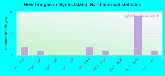
- New bridges - historical statistics
- 21940-1949
- 11950-1959
- 21980-1989
- 11990-1999
- 92010-2019
- 12020-2022
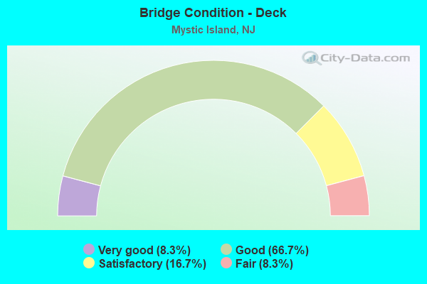
- Bridge Condition - Deck
- 8.3%Very good
- 66.7%Good
- 16.7%Satisfactory
- 8.3%Fair
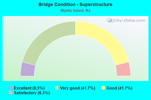
- Bridge Condition - Superstructure
- 8.3%Excellent
- 41.7%Very good
- 41.7%Good
- 8.3%Satisfactory
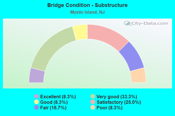
- Bridge Condition - Substructure
- 8.3%Excellent
- 33.3%Very good
- 8.3%Good
- 25.0%Satisfactory
- 16.7%Fair
- 8.3%Poor
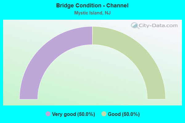
- Bridge Condition - Channel
- 50.0%Very good
- 50.0%Good
Find on map >> Show street view
Structure Number: 302151, Location: 1.0 MI EAST OF GSP JUNC. (Lat: 39.591969, Lng: -74.424831), Route carried "on" structure: US 9, Year Built: 2020, Status: Open, Structure Length: 2.16m (7.09ft), Average Daily Traffic: 9,632 (year 2020), Truck Traffic: 4%, Average Future Daily Traffic: 11,753 (year 2040), Design Load: HL 93, Features Intersected: JOBS CREEK
Minimum Vertical Clearance: 30+ m (98+ ft), Kilometerpoint: 93.422, Lanes on structure: 2, Base Highway Network: Yes, Owner: State Highway Agency, Approaching Roadway Width: 13.0m (42.7ft), Material/Design: Prestressed concrete, Design/Construction: Box Beam or Girders - Multiple, Number Of Spans In Main Unit: 1, Length of Maximum Span: 19.8m (65.0ft), Curb-To-Curb Width: 13.0m (42.7ft), Out-to-Out Width: 14.2m (46.6ft)
Condition: Deck: Good, Superstructure: Excellent, Substructure: Excellent, Channel: Good, Operating Rating: 70.6 metric tons, Method Used To Determine Operating Rating: Load and Resistance Factor Rating (LRFR) rating reported by rating factor(RF) method using HL-93 loadings, Inventory Rating: 28.8 metric tons, Method Used To Determine Inventory Rating: Load and Resistance Factor Rating (LRFR) rating reported by rating factor(RF) method using HL-93 loadings, Structural Evaluation: Better than present minimum criteria, Deck Geometry: Somewhat better than minimum adequacy, Waterway Adequacy: Better than present minimum criteria, Approach Roadway Alignment: Better than present minimum criteria, Length Of Structure Improvement: 1.40m (4.59ft), Designated Inspection Frequency: Every 24 months, Inspection Date: October 2020, Bridge Improvement Cost: $554,000, Roadway Improvement Cost: $76,000, Total Project Cost: $941,000 ( Estimate for 2019), Deck Structure Type: Concrete Cast-file-Place, Wearing Surface/Protective System: Wearing Surface: Epoxy Overlay
Find on map >> Show street view
Structure Number: 3H862, Location: 1.03 M. S. OF CR 679 (Lat: 39.623319, Lng: -74.441050), Route carried "on" structure: County highway 654, Year Built: 1955, Year Reconstructed: 1985, Status: Posted for load, Structure Length: 0.82m (2.69ft), Average Daily Traffic: 2,585 (year 2019), Truck Traffic: 3%, Average Future Daily Traffic: 3,102 (year 2039), Features Intersected: EAST BRANCH BASS RIVER
Minimum Vertical Clearance: 30+ m (98+ ft), Kilometerpoint: 3.541, Lanes on structure: 2, Owner: County Highway Agency, Approaching Roadway Width: 6.7m (22.0ft), Material/Design: Wood or Timber, Design/Construction: Stringer/Multi-beam, Number Of Spans In Main Unit: 2, Length of Maximum Span: 3.7m (12.1ft), Curb-To-Curb Width: 6.6m (21.7ft), Out-to-Out Width: 7.2m (23.6ft)
Condition: Deck: Fair, Superstructure: Satisfactory, Substructure: Poor, Channel: Good, Operating Rating: 30.8 metric tons, Method Used To Determine Operating Rating: Allowable Stress (AS), Inventory Rating: 22.7 metric tons, Method Used To Determine Inventory Rating: Allowable Stress (AS), Structural Evaluation: Meets minimum limits, Deck Geometry: High priority of replacement, Waterway Adequacy: Better than present minimum criteria, Approach Roadway Alignment: Better than present minimum criteria, Length Of Structure Improvement: 1.40m (4.59ft), Designated Inspection Frequency: Every 24 months, Inspection Date: November 2021, Bridge Improvement Cost: $670,000, Roadway Improvement Cost: $200,000, Total Project Cost: $1,164,000 ( Estimate for 2019), Deck Structure Type: Wood or Timber
Find on map >> Show street view
Structure Number: 1516001, Location: 7.5 MI. SO. EXIT 59 GSP (Lat: 39.519419, Lng: -74.319189), Route carried "on" structure: City street , Year Built: 1944, Year Reconstructed: 1992, Status: Open, Structure Length: 9.33m (30.61ft), Average Daily Traffic: 123 (year 2020), Truck Traffic: 3%, Average Future Daily Traffic: 148 (year 2040), Design Load: HS 20+Mod, Features Intersected: LITTLE SHEEPSHEAD CREEK, Facility Carried by Structure: GREAT BAY BLVD.
Minimum Vertical Clearance: 30+ m (98+ ft), Kilometerpoint: 0.000, Lanes on structure: 1, Owner: County Highway Agency, Approaching Roadway Width: 4.9m (16.1ft), Material/Design: Wood or Timber, Design/Construction: Stringer/Multi-beam, Number Of Spans In Main Unit: 23, Length of Maximum Span: 6.1m (20.0ft), Curb-To-Curb Width: 3.7m (12.1ft), Out-to-Out Width: 3.9m (12.8ft)
Condition: Deck: Good, Superstructure: Good, Substructure: Fair, Channel: Very good, Operating Rating: 55.3 metric tons, Method Used To Determine Operating Rating: Allowable Stress (AS), Inventory Rating: 40.8 metric tons, Method Used To Determine Inventory Rating: Allowable Stress (AS), Structural Evaluation: Somewhat better than minimum adequacy, Deck Geometry: High priority of replacement, Waterway Adequacy: Equal to present desirable criteria, Approach Roadway Alignment: Somewhat better than minimum adequacy, Length Of Structure Improvement: 9.33m (30.61ft), Designated Inspection Frequency: Every 24 months, Underwater Inspection Frequency: Every 48 months, Inspection Date: April 2020, Underwater Inspection Date: June 2020, Bridge Improvement Cost: $1,036,000, Roadway Improvement Cost: $104,000, Total Project Cost: $1,608,000 ( Estimate for 2020), Deck Structure Type: Wood or Timber, Wearing Surface/Protective System: Wearing Surface: Wood or Timber
Find on map >> Show street view
Structure Number: 1516002, Location: 7 MI SOUTH EXIT 59 GSP (Lat: 39.532281, Lng: -74.320139), Route carried "on" structure: City street , Year Built: 1944, Year Reconstructed: 1992, Status: Open, Structure Length: 13.35m (43.80ft), Average Daily Traffic: 123 (year 2020), Truck Traffic: 3%, Average Future Daily Traffic: 148 (year 2040), Design Load: HS 20+Mod, Features Intersected: SHEEPSHEAD CREEK, Facility Carried by Structure: GREAT BAY BLVD
Minimum Vertical Clearance: 30+ m (98+ ft), Kilometerpoint: 0.000, Lanes on structure: 1, Owner: County Highway Agency, Approaching Roadway Width: 5.5m (18.0ft), Material/Design: Wood or Timber, Design/Construction: Stringer/Multi-beam, Number Of Spans In Main Unit: 33, Length of Maximum Span: 6.1m (20.0ft), Curb-To-Curb Width: 3.7m (12.1ft), Out-to-Out Width: 3.9m (12.8ft)
Condition: Deck: Satisfactory, Superstructure: Good, Substructure: Fair, Channel: Good, Operating Rating: 55.3 metric tons, Method Used To Determine Operating Rating: Allowable Stress (AS), Inventory Rating: 40.8 metric tons, Method Used To Determine Inventory Rating: Allowable Stress (AS), Structural Evaluation: Somewhat better than minimum adequacy, Deck Geometry: High priority of replacement, Waterway Adequacy: Better than present minimum criteria, Approach Roadway Alignment: Somewhat better than minimum adequacy, Length Of Structure Improvement: 13.35m (43.80ft), Designated Inspection Frequency: Every 24 months, Underwater Inspection Frequency: Every 48 months, Inspection Date: April 2020, Underwater Inspection Date: June 2020, Bridge Improvement Cost: $1,482,000, Roadway Improvement Cost: $148,000, Total Project Cost: $2,131,000 ( Estimate for 2020), Deck Structure Type: Wood or Timber, Wearing Surface/Protective System: Wearing Surface: Wood or Timber
Find on map >> Show street view
Structure Number: 1516003, Location: 6 MI. SO EXIT 58 GSP (Lat: 39.548311, Lng: -74.332311), Route carried "on" structure: City street , Year Built: 1985, Status: Open, Structure Length: 3.17m (10.40ft), Average Daily Traffic: 163 (year 2020), Truck Traffic: 3%, Average Future Daily Traffic: 196 (year 2040), Design Load: HS 20, Features Intersected: JIMMIES OLD CREEK, Facility Carried by Structure: GREAT BAY BLVD
Minimum Vertical Clearance: 30+ m (98+ ft), Kilometerpoint: 0.000, Lanes on structure: 2, Owner: County Highway Agency, Approaching Roadway Width: 8.2m (26.9ft), Navigation Control: Yes ( Vertical Clearance: 2.1m (6.9ft), Horizontal Clearance: 7.3m (24.0ft)), Material/Design: Wood or Timber, Design/Construction: Slab, Number Of Spans In Main Unit: 4, Length of Maximum Span: 7.9m (25.9ft), Curb or Sidewalk Widths: Left: 0.0m, Right: 1.3m (4.3ft), Curb-To-Curb Width: 8.1m (26.6ft), Out-to-Out Width: 10.2m (33.5ft)
Condition: Deck: Good, Superstructure: Good, Substructure: Satisfactory, Channel: Very good, Operating Rating: 37.2 metric tons, Method Used To Determine Operating Rating: Allowable Stress (AS), Inventory Rating: 26.3 metric tons, Method Used To Determine Inventory Rating: Allowable Stress (AS), Structural Evaluation: Equal to present minimum criteria, Deck Geometry: Somewhat better than minimum adequacy, Waterway Adequacy: Equal to present desirable criteria, Approach Roadway Alignment: Equal to present desirable criteria, Designated Inspection Frequency: Every 24 months, Underwater Inspection Frequency: Every 48 months, Inspection Date: April 2020, Underwater Inspection Date: May 2020, Deck Structure Type: Wood or Timber, Wearing Surface/Protective System: Wearing Surface: Bituminous
Find on map >> Show street view
Structure Number: 1516004, Location: 6 MI. SO. EXIT 58 GSP (Lat: 39.554689, Lng: -74.337389), Route carried "on" structure: City street , Year Built: 1985, Status: Open, Structure Length: 6.10m (20.01ft), Average Daily Traffic: 172 (year 2020), Truck Traffic: 3%, Average Future Daily Traffic: 206 (year 2040), Design Load: HS 20, Features Intersected: LITTLE THOROFARE, Facility Carried by Structure: GREAT BAY BLVD.
Minimum Vertical Clearance: 30+ m (98+ ft), Kilometerpoint: 0.000, Lanes on structure: 2, Owner: County Highway Agency, Approaching Roadway Width: 8.2m (26.9ft), Skew: 2 degrees, Navigation Control: Yes ( Vertical Clearance: 3.0m (9.8ft), Horizontal Clearance: 11.3m (37.1ft)), Material/Design: Wood or Timber, Design/Construction: Slab, Number Of Spans In Main Unit: 6, Length of Maximum Span: 12.8m (42.0ft), Curb or Sidewalk Widths: Left: 1.3m (4.3ft), Right: 0.0m, Curb-To-Curb Width: 8.1m (26.6ft), Out-to-Out Width: 10.2m (33.5ft)
Condition: Deck: Good, Superstructure: Good, Substructure: Satisfactory, Channel: Very good, Operating Rating: 38.1 metric tons, Method Used To Determine Operating Rating: Allowable Stress (AS), Inventory Rating: 26.3 metric tons, Method Used To Determine Inventory Rating: Allowable Stress (AS), Structural Evaluation: Equal to present minimum criteria, Deck Geometry: Somewhat better than minimum adequacy, Waterway Adequacy: Equal to present desirable criteria, Approach Roadway Alignment: Equal to present desirable criteria, Designated Inspection Frequency: Every 24 months, Underwater Inspection Frequency: Every 48 months, Inspection Date: April 2020, Underwater Inspection Date: April 2020, Deck Structure Type: Wood or Timber, Wearing Surface/Protective System: Wearing Surface: Bituminous
Find on map >> Show street view
Structure Number: 1516005, Location: 6 MI. SO EXIT 58 GSP (Lat: 39.564639, Lng: -74.342281), Route carried "on" structure: City street , Year Built: 1995, Status: Open, Structure Length: 13.59m (44.59ft), Average Daily Traffic: 192 (year 2020), Truck Traffic: 3%, Average Future Daily Traffic: 230 (year 2040), Design Load: HS 20+Mod, Features Intersected: BIG THOROFARE, Facility Carried by Structure: GREAT BAY BLVD
Minimum Vertical Clearance: 30+ m (98+ ft), Kilometerpoint: 0.000, Lanes on structure: 2, Owner: County Highway Agency, Approaching Roadway Width: 7.9m (25.9ft), Skew: 1 degrees, Navigation Control: Yes ( Vertical Clearance: 6.4m (21.0ft), Horizontal Clearance: 15.2m (49.9ft)), Material/Design: Wood or Timber, Design/Construction: Stringer/Multi-beam, Number Of Spans In Main Unit: 1, Number Of Approach Spans: 12, Length of Maximum Span: 21.9m (71.9ft), Curb or Sidewalk Widths: Left: 1.3m (4.3ft), Right: 0.0m, Curb-To-Curb Width: 7.9m (25.9ft), Out-to-Out Width: 10.3m (33.8ft)
Condition: Deck: Good, Superstructure: Good, Substructure: Satisfactory, Channel: Good, Operating Rating: 39.9 metric tons, Method Used To Determine Operating Rating: Allowable Stress (AS), Inventory Rating: 28.1 metric tons, Method Used To Determine Inventory Rating: Allowable Stress (AS), Structural Evaluation: Equal to present minimum criteria, Deck Geometry: Somewhat better than minimum adequacy, Waterway Adequacy: Better than present minimum criteria, Approach Roadway Alignment: Equal to present minimum criteria, Designated Inspection Frequency: Every 24 months, Underwater Inspection Frequency: Every 48 months, Inspection Date: April 2020, Underwater Inspection Date: May 2020, Deck Structure Type: Wood or Timber, Wearing Surface/Protective System: Wearing Surface: Bituminous
Find on map >> Show street view
Structure Number: 1516006, Location: 3.74 MI S.OF US 9 (Lat: 39.553950, Lng: -74.374511), Route carried "on" structure: County highway 601, Year Built: 2013, Status: Open, Structure Length: 4.27m (14.01ft), Average Daily Traffic: 4,745 (year 2020), Truck Traffic: 4%, Average Future Daily Traffic: 5,790 (year 2040), Design Load: HS 25 or greater, Features Intersected: BIG CREEK
Minimum Vertical Clearance: 30+ m (98+ ft), Kilometerpoint: 6.148, Lanes on structure: 2, Owner: County Highway Agency, Approaching Roadway Width: 12.2m (40.0ft), Navigation Control: Yes ( Vertical Clearance: 3.7m (12.1ft), Horizontal Clearance: 12.8m (42.0ft)), Material/Design: Prestressed concrete, Design/Construction: Box Beam or Girders - Multiple, Number Of Spans In Main Unit: 3, Length of Maximum Span: 13.7m (44.9ft), Curb or Sidewalk Widths: Left: 0.3m (1.0ft), Right: 1.5m (4.9ft), Curb-To-Curb Width: 12.2m (40.0ft), Out-to-Out Width: 14.9m (48.9ft)
Condition: Deck: Satisfactory, Superstructure: Very good, Substructure: Very good, Channel: Very good, Inventory Rating: 58.1 metric tons, Method Used To Determine Inventory Rating: Load Factor (LF), Structural Evaluation: Equal to present desirable criteria, Deck Geometry: Equal to present minimum criteria, Waterway Adequacy: Equal to present desirable criteria, Approach Roadway Alignment: Equal to present desirable criteria, Designated Inspection Frequency: Every 24 months, Underwater Inspection Frequency: Every 48 months, Inspection Date: May 2020, Underwater Inspection Date: May 2018, Deck Structure Type: Concrete Cast-file-Place, Wearing Surface/Protective System: Deck Protection: Epoxy Coated Reinforcing
Find on map >> Show street view
Structure Number: 360527N, Location: 0.7 MI N OF RT9 & GSP JCT (Lat: 39.603697, Lng: -74.434753), Route carried "on" structure: County highway 654, Year Built: 2013, Status: Open, Structure Length: 3.11m (10.20ft), Average Daily Traffic: 2,388 (year 2021), Truck Traffic: 3%, Average Future Daily Traffic: 2,914 (year 2041), Design Load: HL 93, Features Intersected: GSP NB, Facility Carried by Structure: E. GREENBUSH RD
Minimum Vertical Clearance: 30+ m (98+ ft), Kilometerpoint: 1.143, Lanes on structure: 2, Lanes under structure: 4, Owner: State Toll Authority, Approaching Roadway Width: 11.0m (36.1ft), Skew: 2 degrees, Material/Design: Steel, Design/Construction: Stringer/Multi-beam, Number Of Spans In Main Unit: 1, Length of Maximum Span: 29.6m (97.1ft), Curb or Sidewalk Widths: Left: 0.0m, Right: 1.8m (5.9ft), Curb-To-Curb Width: 11.0m (36.1ft), Out-to-Out Width: 13.7m (44.9ft)
Condition: Deck: Good, Superstructure: Very good, Substructure: Very good, Operating Rating: 75.8 metric tons, Method Used To Determine Operating Rating: Load and Resistance Factor Rating (LRFR) rating reported by rating factor(RF) method using HL-93 loadings, Inventory Rating: 58.3 metric tons, Method Used To Determine Inventory Rating: Load and Resistance Factor Rating (LRFR) rating reported by rating factor(RF) method using HL-93 loadings, Structural Evaluation: Equal to present desirable criteria, Deck Geometry: Somewhat better than minimum adequacy, Underclear: Equal to present minimum criteria, Approach Roadway Alignment: Equal to present desirable criteria, Designated Inspection Frequency: Every 24 months, Inspection Date: March 2021, Deck Structure Type: Concrete Cast-file-Place, Wearing Surface/Protective System: Wearing Surface: Monolithic Concrete, Deck Protection: Epoxy Coated Reinforcing
Find on map >> Show street view
Structure Number: 360528S, Location: 0.8 MI N OF RT9 & GSP JCT (Lat: 39.604783, Lng: -74.435475), Route carried "on" structure: County highway 654, Year Built: 2013, Status: Open, Structure Length: 2.68m (8.79ft), Average Daily Traffic: 2,388 (year 2021), Truck Traffic: 3%, Average Future Daily Traffic: 2,914 (year 2041), Design Load: HL 93, Features Intersected: GSP SB, Facility Carried by Structure: E. GREENBUSH ROAD
Minimum Vertical Clearance: 30+ m (98+ ft), Kilometerpoint: 1.287, Lanes on structure: 2, Lanes under structure: 3, Owner: State Toll Authority, Approaching Roadway Width: 11.0m (36.1ft), Skew: 2 degrees, Material/Design: Steel, Design/Construction: Stringer/Multi-beam, Number Of Spans In Main Unit: 1, Length of Maximum Span: 25.3m (83.0ft), Curb or Sidewalk Widths: Left: 0.0m, Right: 1.8m (5.9ft), Curb-To-Curb Width: 11.0m (36.1ft), Out-to-Out Width: 13.7m (44.9ft)
Condition: Deck: Very good, Superstructure: Very good, Substructure: Very good, Operating Rating: 63.2 metric tons, Method Used To Determine Operating Rating: Load and Resistance Factor Rating (LRFR) rating reported by rating factor(RF) method using HL-93 loadings, Inventory Rating: 48.6 metric tons, Method Used To Determine Inventory Rating: Load and Resistance Factor Rating (LRFR) rating reported by rating factor(RF) method using HL-93 loadings, Structural Evaluation: Equal to present desirable criteria, Deck Geometry: Somewhat better than minimum adequacy, Underclear: Somewhat better than minimum adequacy, Approach Roadway Alignment: Equal to present desirable criteria, Designated Inspection Frequency: Every 24 months, Inspection Date: March 2021, Deck Structure Type: Concrete Cast-file-Place, Wearing Surface/Protective System: Wearing Surface: Monolithic Concrete, Deck Protection: Epoxy Coated Reinforcing
Find on map >> Show street view
Structure Number: 360543N, Location: 2.5 MI NE OF US9&GSP JCT (Lat: 39.617589, Lng: -74.411875), Route carried "on" structure: City street , Year Built: 2013, Status: Open, Structure Length: 4.36m (14.30ft), Average Daily Traffic: 2,027 (year 2021), Truck Traffic: 5%, Average Future Daily Traffic: 2,474 (year 2041), Design Load: HL 93, Features Intersected: GSP NB, Facility Carried by Structure: STAGE ROAD
Minimum Vertical Clearance: 30+ m (98+ ft), Kilometerpoint: 0.000, Lanes on structure: 2, Lanes under structure: 3, Owner: State Toll Authority, Approaching Roadway Width: 11.0m (36.1ft), Skew: 5 degrees, Material/Design: Steel, Design/Construction: Stringer/Multi-beam, Number Of Spans In Main Unit: 1, Length of Maximum Span: 40.2m (131.9ft), Curb or Sidewalk Widths: Left: 1.8m (5.9ft), Right: 0.0m, Curb-To-Curb Width: 11.0m (36.1ft), Out-to-Out Width: 13.7m (44.9ft)
Condition: Deck: Good, Superstructure: Very good, Substructure: Good, Operating Rating: 48.6 metric tons, Method Used To Determine Operating Rating: Load and Resistance Factor Rating (LRFR) rating reported by rating factor(RF) method using HL-93 loadings, Inventory Rating: 37.6 metric tons, Method Used To Determine Inventory Rating: Load and Resistance Factor Rating (LRFR) rating reported by rating factor(RF) method using HL-93 loadings, Structural Evaluation: Better than present minimum criteria, Deck Geometry: Somewhat better than minimum adequacy, Underclear: Somewhat better than minimum adequacy, Approach Roadway Alignment: Equal to present desirable criteria, Designated Inspection Frequency: Every 24 months, Inspection Date: March 2021, Deck Structure Type: Concrete Cast-file-Place, Wearing Surface/Protective System: Wearing Surface: Monolithic Concrete, Deck Protection: Epoxy Coated Reinforcing
Find on map >> Show street view
Structure Number: 360543S, Location: 2.5 MI NE OF RTE9&GSP JCT (Lat: 39.618028, Lng: -74.414056), Route carried "on" structure: City street , Year Built: 2013, Status: Open, Structure Length: 4.15m (13.62ft), Average Daily Traffic: 2,027 (year 2021), Truck Traffic: 5%, Average Future Daily Traffic: 2,474 (year 2041), Design Load: HL 93, Features Intersected: GSP SB, Facility Carried by Structure: STAGE ROAD
Minimum Vertical Clearance: 30+ m (98+ ft), Kilometerpoint: 0.000, Lanes on structure: 2, Lanes under structure: 3, Owner: State Toll Authority, Approaching Roadway Width: 11.0m (36.1ft), Skew: 5 degrees, Material/Design: Steel, Design/Construction: Stringer/Multi-beam, Number Of Spans In Main Unit: 1, Length of Maximum Span: 38.4m (126.0ft), Curb or Sidewalk Widths: Left: 1.8m (5.9ft), Right: 0.0m, Curb-To-Curb Width: 11.0m (36.1ft), Out-to-Out Width: 13.7m (44.9ft)
Condition: Deck: Good, Superstructure: Very good, Substructure: Very good, Operating Rating: 56.7 metric tons, Method Used To Determine Operating Rating: Load and Resistance Factor Rating (LRFR) rating reported by rating factor(RF) method using HL-93 loadings, Inventory Rating: 43.7 metric tons, Method Used To Determine Inventory Rating: Load and Resistance Factor Rating (LRFR) rating reported by rating factor(RF) method using HL-93 loadings, Structural Evaluation: Equal to present desirable criteria, Deck Geometry: Somewhat better than minimum adequacy, Underclear: Meets minimum limits, Approach Roadway Alignment: Equal to present desirable criteria, Designated Inspection Frequency: Every 24 months, Inspection Date: March 2021, Deck Structure Type: Concrete Cast-file-Place, Wearing Surface/Protective System: Wearing Surface: Monolithic Concrete, Deck Protection: Epoxy Coated Reinforcing
Find on map >> Show street view
Structure Number: 360527N, Location: 0.7 MI N OF RT9 & GSP JCT (Lat: 39.603697, Lng: -74.434753), Route carried "under" structure: Other road GSP, Year Built: 2013, Structure Length: 0. m, Average Daily Traffic: 40,786 (year 2021), Truck Traffic: 3%, Features Intersected: GSP NB, Facility Carried by Structure: E. GREENBUSH RD
Minimum Vertical Clearance: 5.03m (16.50ft), Kilometerpoint: 84.812, Lanes on structure: 2, Lanes under structure: 4, Toll: On toll road, Material/Design: Steel, Design/Construction: Stringer/Multi-beam, Length of Maximum Span: 29.6m (97.1ft)
Find on map >> Show street view
Structure Number: 360528S, Location: 0.8 MI N OF RT9 & GSP JCT (Lat: 39.604783, Lng: -74.435475), Route carried "under" structure: Other road GSP, Year Built: 2013, Structure Length: 0. m, Average Daily Traffic: 24,274 (year 2021), Truck Traffic: 3%, Features Intersected: GSP SB, Facility Carried by Structure: E. GREENBUSH ROAD
Minimum Vertical Clearance: 5.21m (17.09ft), Kilometerpoint: 84.812, Lanes on structure: 2, Lanes under structure: 3, Toll: On toll road, Material/Design: Steel, Design/Construction: Stringer/Multi-beam, Length of Maximum Span: 25.3m (83.0ft)
Find on map >> Show street view
Structure Number: 360543N, Location: 2.5 MI NE OF US9&GSP JCT (Lat: 39.617589, Lng: -74.411875), Route carried "under" structure: Other road GSP, Year Built: 2013, Structure Length: 0. m, Average Daily Traffic: 31,700 (year 2021), Truck Traffic: 3%, Features Intersected: GSP NB, Facility Carried by Structure: STAGE ROAD
Minimum Vertical Clearance: 5.16m (16.93ft), Kilometerpoint: 87.371, Lanes on structure: 2, Lanes under structure: 3, Toll: On toll road, Material/Design: Steel, Design/Construction: Stringer/Multi-beam, Length of Maximum Span: 40.2m (131.9ft)
Find on map >> Show street view
Structure Number: 360543S, Location: 2.5 MI NE OF RTE9&GSP JCT (Lat: 39.618028, Lng: -74.414056), Route carried "under" structure: Other road GSP, Year Built: 2013, Structure Length: 0. m, Average Daily Traffic: 35,326 (year 2021), Truck Traffic: 3%, Features Intersected: GSP SB, Facility Carried by Structure: STAGE ROAD
Minimum Vertical Clearance: 5.28m (17.32ft), Kilometerpoint: 87.371, Lanes on structure: 2, Lanes under structure: 3, Toll: On toll road, Material/Design: Steel, Design/Construction: Stringer/Multi-beam, Length of Maximum Span: 38.4m (126.0ft)