Bridge Statistics for Naco, Arizona (AZ)
Condition, Traffic, Stress, Structural Evaluation, Project Costs
- National Bridge Inventory (NBI) Statistics
- 12Number of bridges
- 59ft / 17.9mTotal length
- $2,000Total costs
- 21,388Total average daily traffic
- 2,178Total average daily truck traffic
- 21,508Total future (year 2034) average daily traffic
- National Bridge Inventory (NBI) Registered Bridges for Naco
- No street view available for this location
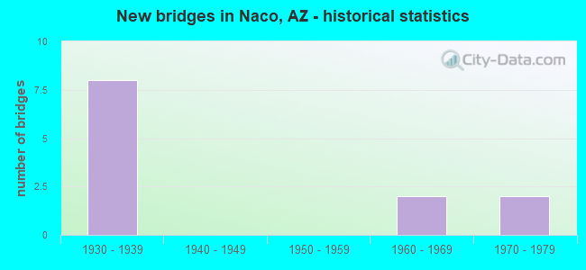
- New bridges - historical statistics
- 81930-1939
- 21960-1969
- 21970-1979


- Bridge Condition - Deck
- 66.7%Satisfactory
- 33.3%Fair

- Bridge Condition - Superstructure
- 66.7%Satisfactory
- 33.3%Fair

- Bridge Condition - Substructure
- 33.3%Good
- 33.3%Satisfactory
- 33.3%Fair

- Bridge Condition - Channel
- 9.1%Very good
- 54.5%Good
- 36.4%Satisfactory

- Bridge Condition - Culverts
- 22.2%Very good
- 33.3%Good
- 44.4%Satisfactory
Find on map >> Show street view
Structure Number: 686, Location: 37.2 mi W Jct SR 85 (Lat: 32.835786, Lng: -113.357658), Route carried "on" structure: Interstate 8, Year Built: 1962, Status: Open, Structure Length: 2.96m (9.71ft), Average Daily Traffic: 4,810 (year 2019), Truck Traffic: 24%, Average Future Daily Traffic: 4,820 (year 2039), Design Load: HS 20, Features Intersected: Spot Rd
Minimum Vertical Clearance: 30+ m (98+ ft), Kilometerpoint: 126.173, Lanes on structure: 2, Lanes under structure: 2, Owner: State Highway Agency, Approaching Roadway Width: 11.6m (38.1ft), Material/Design: Concrete continuous, Design/Construction: Slab, Number Of Spans In Main Unit: 3, Length of Maximum Span: 11.0m (36.1ft), Curb-To-Curb Width: 12.1m (39.7ft), Out-to-Out Width: 13.1m (43.0ft)
Condition: Deck: Satisfactory, Superstructure: Satisfactory, Substructure: Good, Operating Rating: 62.6 metric tons, Method Used To Determine Operating Rating: Load Factor (LF), Inventory Rating: 38.1 metric tons, Method Used To Determine Inventory Rating: Load Factor (LF), Structural Evaluation: Equal to present minimum criteria, Deck Geometry: Equal to present minimum criteria, Underclear: High priority of corrective action, Approach Roadway Alignment: Equal to present desirable criteria, Designated Inspection Frequency: Every 24 months, Inspection Date: Febuary 2021, Deck Structure Type: Concrete Cast-file-Place, Wearing Surface/Protective System: Wearing Surface: Bituminous
Find on map >> Show street view
Structure Number: 4883, Location: 8.1 mi W Jct US 80 (Lat: 31.375306, Lng: -110.002833), Route carried "on" structure: State highway 92, Year Built: 1938, Year Reconstructed: 1967, Status: Open, Structure Length: 0.64m (2.10ft), Average Daily Traffic: 4,080 (year 2014), Truck Traffic: 10%, Average Future Daily Traffic: 4,090 (year 2034), Design Load: HS 20, Features Intersected: Wash
Minimum Vertical Clearance: 30+ m (98+ ft), Kilometerpoint: 558.442, Lanes on structure: 2, Owner: State Highway Agency, Approaching Roadway Width: 12.5m (41.0ft), Material/Design: Concrete continuous, Design/Construction: Culvert, Number Of Spans In Main Unit: 2, Length of Maximum Span: 3.0m (9.8ft)
Condition: Channel: Very good, Culverts: Very good, Operating Rating: 65.3 metric tons, Method Used To Determine Operating Rating: Load Factor (LF), Inventory Rating: 39.0 metric tons, Method Used To Determine Inventory Rating: Load Factor (LF), Structural Evaluation: Equal to present desirable criteria, Waterway Adequacy: Equal to present desirable criteria, Approach Roadway Alignment: Equal to present desirable criteria, Designated Inspection Frequency: Every 48 months, Inspection Date: June 2020
Find on map >> Show street view
Structure Number: 4884, Location: 7.7 mi W Jct US 80 (Lat: 31.374528, Lng: -109.996833), Route carried "on" structure: State highway 92, Year Built: 1938, Year Reconstructed: 1967, Status: Open, Structure Length: 0.64m (2.10ft), Average Daily Traffic: 4,080 (year 2018), Truck Traffic: 10%, Average Future Daily Traffic: 4,090 (year 2038), Design Load: HS 20, Features Intersected: Wash
Minimum Vertical Clearance: 30+ m (98+ ft), Kilometerpoint: 559.038, Lanes on structure: 2, Owner: State Highway Agency, Approaching Roadway Width: 12.2m (40.0ft), Material/Design: Concrete continuous, Design/Construction: Culvert, Number Of Spans In Main Unit: 2, Length of Maximum Span: 3.0m (9.8ft)
Condition: Channel: Good, Culverts: Very good, Operating Rating: 65.3 metric tons, Method Used To Determine Operating Rating: Load Factor (LF), Inventory Rating: 39.0 metric tons, Method Used To Determine Inventory Rating: Load Factor (LF), Structural Evaluation: Equal to present desirable criteria, Waterway Adequacy: Equal to present desirable criteria, Approach Roadway Alignment: Equal to present desirable criteria, Designated Inspection Frequency: Every 48 months, Inspection Date: June 2020
Find on map >> Show street view
Structure Number: 8096, Location: 0.6 mi E Jct Naco Rd (Lat: 31.350858, Lng: -109.926661), Route carried "on" structure: County highway , Year Built: 1938, Status: Open, Structure Length: 0.82m (2.69ft), Average Daily Traffic: 500 (year 2021), Truck Traffic: 10%, Average Future Daily Traffic: 510 (year 2041), Design Load: HS 20, Features Intersected: Desert Wash, Facility Carried by Structure: Purdy Lane
Minimum Vertical Clearance: 30+ m (98+ ft), Kilometerpoint: 0.000, Lanes on structure: 2, Owner: County Highway Agency, Approaching Roadway Width: 6.7m (22.0ft), Material/Design: Concrete continuous, Design/Construction: Culvert, Number Of Spans In Main Unit: 4, Length of Maximum Span: 1.8m (5.9ft), Curb or Sidewalk Widths: Left: 0.2m (0.7ft), Right: 0.2m (0.7ft), Curb-To-Curb Width: 6.9m (22.6ft), Out-to-Out Width: 7.3m (24.0ft)
Condition: Channel: Good, Culverts: Satisfactory, Operating Rating: 52.6 metric tons, Method Used To Determine Operating Rating: Load Factor (LF), Inventory Rating: 31.8 metric tons, Method Used To Determine Inventory Rating: Load Factor (LF), Structural Evaluation: Equal to present minimum criteria, Deck Geometry: Meets minimum limits, Waterway Adequacy: Better than present minimum criteria, Approach Roadway Alignment: Equal to present desirable criteria, Designated Inspection Frequency: Every 48 months, Inspection Date: January 2021, Deck Structure Type: Concrete Cast-file-Place, Wearing Surface/Protective System: Wearing Surface: Bituminous
Find on map >> Show street view
Structure Number: 8097, Location: 1.0 mi E Jct Naco Rd (Lat: 31.350858, Lng: -109.919086), Route carried "on" structure: County highway , Year Built: 1938, Status: Open, Structure Length: 0.79m (2.59ft), Average Daily Traffic: 500 (year 2021), Truck Traffic: 2%, Average Future Daily Traffic: 510 (year 2041), Design Load: HS 20, Features Intersected: Wash, Facility Carried by Structure: Purdy Lane
Minimum Vertical Clearance: 30+ m (98+ ft), Kilometerpoint: 0.000, Lanes on structure: 2, Owner: County Highway Agency, Approaching Roadway Width: 6.7m (22.0ft), Material/Design: Concrete continuous, Design/Construction: Culvert, Number Of Spans In Main Unit: 4, Length of Maximum Span: 1.8m (5.9ft), Curb or Sidewalk Widths: Left: 0.2m (0.7ft), Right: 0.2m (0.7ft), Curb-To-Curb Width: 6.9m (22.6ft), Out-to-Out Width: 7.3m (24.0ft)
Condition: Channel: Good, Culverts: Satisfactory, Operating Rating: 52.6 metric tons, Method Used To Determine Operating Rating: Load Factor (LF), Inventory Rating: 31.8 metric tons, Method Used To Determine Inventory Rating: Load Factor (LF), Structural Evaluation: Equal to present minimum criteria, Deck Geometry: Meets minimum limits, Waterway Adequacy: Better than present minimum criteria, Approach Roadway Alignment: Equal to present desirable criteria, Designated Inspection Frequency: Every 48 months, Inspection Date: January 2021, Deck Structure Type: Concrete Cast-file-Place, Wearing Surface/Protective System: Wearing Surface: Bituminous
Find on map >> Show street view
Structure Number: 8114, Location: 1.4 mi E Jct Naco Rd (Lat: 31.350850, Lng: -109.912017), Route carried "on" structure: County highway , Year Built: 1938, Status: Open, Structure Length: 0.64m (2.10ft), Average Daily Traffic: 500 (year 2021), Truck Traffic: 2%, Average Future Daily Traffic: 510 (year 2041), Design Load: HS 20, Features Intersected: Wash, Facility Carried by Structure: Purdy Lane
Minimum Vertical Clearance: 30+ m (98+ ft), Kilometerpoint: 0.000, Lanes on structure: 2, Owner: County Highway Agency, Approaching Roadway Width: 6.7m (22.0ft), Material/Design: Concrete continuous, Design/Construction: Culvert, Number Of Spans In Main Unit: 3, Length of Maximum Span: 1.8m (5.9ft), Curb or Sidewalk Widths: Left: 0.2m (0.7ft), Right: 0.2m (0.7ft), Curb-To-Curb Width: 6.9m (22.6ft), Out-to-Out Width: 7.3m (24.0ft)
Condition: Channel: Good, Culverts: Satisfactory, Operating Rating: 52.6 metric tons, Method Used To Determine Operating Rating: Load Factor (LF), Inventory Rating: 31.8 metric tons, Method Used To Determine Inventory Rating: Load Factor (LF), Structural Evaluation: Equal to present minimum criteria, Deck Geometry: Meets minimum limits, Waterway Adequacy: Better than present minimum criteria, Approach Roadway Alignment: Equal to present desirable criteria, Designated Inspection Frequency: Every 48 months, Inspection Date: January 2021, Deck Structure Type: Concrete Cast-file-Place, Wearing Surface/Protective System: Wearing Surface: Bituminous
Find on map >> Show street view
Structure Number: 8117, Location: 1.7 mi E Jct Naco Rd (Lat: 31.350847, Lng: -109.906792), Route carried "on" structure: County highway , Year Built: 1938, Status: Open, Structure Length: 0.64m (2.10ft), Average Daily Traffic: 625 (year 2021), Truck Traffic: 2%, Average Future Daily Traffic: 635 (year 2041), Design Load: HS 20, Features Intersected: Desert Wash, Facility Carried by Structure: Purdy Lane
Minimum Vertical Clearance: 30+ m (98+ ft), Kilometerpoint: 0.000, Lanes on structure: 2, Owner: County Highway Agency, Approaching Roadway Width: 6.7m (22.0ft), Material/Design: Concrete continuous, Design/Construction: Culvert, Number Of Spans In Main Unit: 3, Length of Maximum Span: 1.8m (5.9ft), Curb or Sidewalk Widths: Left: 0.2m (0.7ft), Right: 0.2m (0.7ft), Curb-To-Curb Width: 6.9m (22.6ft), Out-to-Out Width: 7.3m (24.0ft)
Condition: Channel: Good, Culverts: Satisfactory, Operating Rating: 52.6 metric tons, Method Used To Determine Operating Rating: Load Factor (LF), Inventory Rating: 31.8 metric tons, Method Used To Determine Inventory Rating: Load Factor (LF), Structural Evaluation: Equal to present minimum criteria, Deck Geometry: Meets minimum limits, Waterway Adequacy: Better than present minimum criteria, Approach Roadway Alignment: Equal to present desirable criteria, Designated Inspection Frequency: Every 48 months, Inspection Date: January 2021, Deck Structure Type: Concrete Cast-file-Place, Wearing Surface/Protective System: Wearing Surface: Bituminous
Find on map >> Show street view
Structure Number: 8118, Location: 2.5 mi E Jct Naco Hwy (Lat: 31.350800, Lng: -109.893900), Route carried "on" structure: County highway , Year Built: 1938, Status: Open, Structure Length: 1.34m (4.40ft), Average Daily Traffic: 500 (year 2021), Average Future Daily Traffic: 510 (year 2041), Features Intersected: Green Bush Draw, Facility Carried by Structure: Purdy Lane
Minimum Vertical Clearance: 30+ m (98+ ft), Kilometerpoint: 0.000, Lanes on structure: 2, Owner: County Highway Agency, Approaching Roadway Width: 6.7m (22.0ft), Skew: 5 degrees, Material/Design: Concrete continuous, Design/Construction: Slab, Number Of Spans In Main Unit: 3, Length of Maximum Span: 4.3m (14.1ft), Curb or Sidewalk Widths: Left: 0.3m (1.0ft), Right: 0.3m (1.0ft), Curb-To-Curb Width: 6.8m (22.3ft), Out-to-Out Width: 7.4m (24.3ft)
Condition: Deck: Fair, Superstructure: Fair, Substructure: Satisfactory, Channel: Satisfactory, Operating Rating: 36.3 metric tons, Method Used To Determine Operating Rating: Load Factor (LF), Inventory Rating: 21.8 metric tons, Method Used To Determine Inventory Rating: Load Factor (LF), Structural Evaluation: Somewhat better than minimum adequacy, Deck Geometry: Meets minimum limits, Waterway Adequacy: Equal to present desirable criteria, Approach Roadway Alignment: Equal to present desirable criteria, Length Of Structure Improvement: 2.10m (6.89ft), Designated Inspection Frequency: Every 24 months, Inspection Date: Febuary 2021, Total Project Cost: $1,000 ( Estimate for 2021), Deck Structure Type: Concrete Cast-file-Place, Wearing Surface/Protective System: Wearing Surface: Bituminous
Find on map >> Show street view
Structure Number: 9218, Location: @ Jct Purdy Lane (Lat: 31.350847, Lng: -109.936081), Route carried "on" structure: County highway , Year Built: 1961, Status: Open, Structure Length: 2.77m (9.09ft), Average Daily Traffic: 2,100 (year 2021), Truck Traffic: 3%, Average Future Daily Traffic: 2,110 (year 2041), Design Load: HS 20, Features Intersected: Desert Wash, Facility Carried by Structure: Naco-Don Luis Hwy
Minimum Vertical Clearance: 7.62m (25.00ft), Kilometerpoint: 4.828, Lanes on structure: 3, Owner: County Highway Agency, Approaching Roadway Width: 12.5m (41.0ft), Skew: 4 degrees, Material/Design: Concrete continuous, Design/Construction: Culvert, Number Of Spans In Main Unit: 6, Length of Maximum Span: 3.0m (9.8ft)
Condition: Channel: Satisfactory, Culverts: Good, Operating Rating: 63.5 metric tons, Method Used To Determine Operating Rating: Load Factor (LF), Inventory Rating: 38.1 metric tons, Method Used To Determine Inventory Rating: Load Factor (LF), Structural Evaluation: Better than present minimum criteria, Waterway Adequacy: Equal to present minimum criteria, Approach Roadway Alignment: Equal to present desirable criteria, Designated Inspection Frequency: Every 48 months, Inspection Date: January 2021
Find on map >> Show street view
Structure Number: 9219, Location: 5.5 mi S Jct SR 80 (Lat: 31.355200, Lng: -109.888000), Route carried "on" structure: County highway , Year Built: 1939, Status: Posted for load, Structure Length: 1.04m (3.41ft), Average Daily Traffic: 500 (year 2021), Average Future Daily Traffic: 510 (year 2041), Features Intersected: Greenbush Draw, Facility Carried by Structure: Warren Road
Minimum Vertical Clearance: 30+ m (98+ ft), Kilometerpoint: 0.000, Lanes on structure: 2, Owner: County Highway Agency, Approaching Roadway Width: 7.3m (24.0ft), Material/Design: Concrete continuous, Design/Construction: Slab, Number Of Spans In Main Unit: 2, Length of Maximum Span: 4.6m (15.1ft), Curb or Sidewalk Widths: Left: 0.2m (0.7ft), Right: 0.2m (0.7ft), Curb-To-Curb Width: 7.3m (24.0ft), Out-to-Out Width: 7.8m (25.6ft)
Condition: Deck: Satisfactory, Superstructure: Satisfactory, Substructure: Fair, Channel: Satisfactory, Operating Rating: 29.9 metric tons, Method Used To Determine Operating Rating: Load Factor (LF), Inventory Rating: 17.2 metric tons, Method Used To Determine Inventory Rating: Load Factor (LF), Structural Evaluation: Somewhat better than minimum adequacy, Deck Geometry: Meets minimum limits, Waterway Adequacy: Equal to present minimum criteria, Approach Roadway Alignment: Equal to present desirable criteria, Bridge Posting: Required (Relationship of Operating Rating to Maximum Legal Load: 10.0 - 19.9% below), Length Of Structure Improvement: 1.80m (5.91ft), Designated Inspection Frequency: Every 24 months, Inspection Date: Febuary 2021, Total Project Cost: $1,000 ( Estimate for 2021), Deck Structure Type: Concrete Cast-file-Place, Wearing Surface/Protective System: Wearing Surface: Bituminous
Find on map >> Show street view
Structure Number: 9536, Location: 1.1 mi S Jct Purdy Lane (Lat: 31.335250, Lng: -109.938850), Route carried "on" structure: County highway , Year Built: 1974, Status: Open, Structure Length: 0.64m (2.10ft), Average Daily Traffic: 1,200 (year 2021), Truck Traffic: 2%, Average Future Daily Traffic: 1,210 (year 2041), Design Load: HS 20, Features Intersected: Wash, Facility Carried by Structure: Naco-Don Luis Hwy
Minimum Vertical Clearance: 30+ m (98+ ft), Kilometerpoint: 0.000, Lanes on structure: 2, Owner: County Highway Agency, Approaching Roadway Width: 12.2m (40.0ft), Material/Design: Concrete continuous, Design/Construction: Culvert, Number Of Spans In Main Unit: 2, Length of Maximum Span: 3.0m (9.8ft)
Condition: Channel: Good, Culverts: Good, Operating Rating: 89.8 metric tons, Method Used To Determine Operating Rating: Load Factor (LF), Inventory Rating: 89.8 metric tons, Method Used To Determine Inventory Rating: Load Factor (LF), Structural Evaluation: Better than present minimum criteria, Waterway Adequacy: Better than present minimum criteria, Approach Roadway Alignment: Equal to present minimum criteria, Designated Inspection Frequency: Every 48 months, Inspection Date: January 2021
Find on map >> Show street view
Structure Number: 9537, Location: 0.6 mi S Jct Purdy Lane (Lat: 31.342667, Lng: -109.936083), Route carried "on" structure: County highway , Year Built: 1974, Status: Open, Structure Length: 4.97m (16.31ft), Average Daily Traffic: 1,993 (year 2016), Truck Traffic: 2%, Average Future Daily Traffic: 2,003 (year 2037), Design Load: HS 20, Features Intersected: Greenbush Draw, Facility Carried by Structure: Naco-Don Luis Hwy
Minimum Vertical Clearance: 30+ m (98+ ft), Kilometerpoint: 0.000, Lanes on structure: 2, Owner: County Highway Agency, Approaching Roadway Width: 12.2m (40.0ft), Skew: 9 degrees, Material/Design: Concrete continuous, Design/Construction: Culvert, Number Of Spans In Main Unit: 8, Length of Maximum Span: 3.0m (9.8ft)
Condition: Channel: Satisfactory, Culverts: Good, Operating Rating: 89.8 metric tons, Method Used To Determine Operating Rating: Load Factor (LF), Inventory Rating: 89.8 metric tons, Method Used To Determine Inventory Rating: Load Factor (LF), Structural Evaluation: Better than present minimum criteria, Waterway Adequacy: Better than present minimum criteria, Approach Roadway Alignment: Equal to present desirable criteria, Designated Inspection Frequency: Every 48 months, Inspection Date: January 2021