Bridge Statistics for Nanticoke, Pennsylvania (PA)
Condition, Traffic, Stress, Structural Evaluation, Project Costs
- National Bridge Inventory (NBI) Statistics
- 12Number of bridges
- 512ft / 156mTotal length
- $19,115,000Total costs
- 89,893Total average daily traffic
- 4,765Total average daily truck traffic
- National Bridge Inventory (NBI) Registered Bridges for Nanticoke
- No street view available for this location
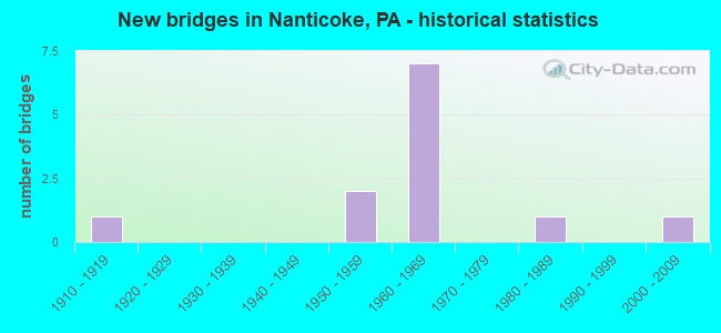
- New bridges - historical statistics
- 11910-1919
- 21950-1959
- 71960-1969
- 11980-1989
- 12000-2009
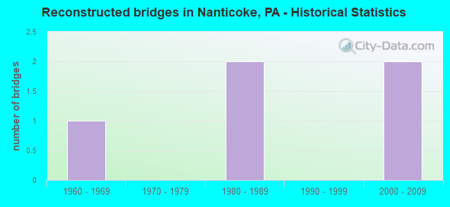
- Reconstructed bridges - Historical Statistics
- 11960-1969
- 01970-1979
- 21980-1989
- 01990-1999
- 22000-2009
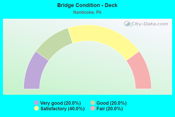
- Bridge Condition - Deck
- 20.0%Very good
- 20.0%Good
- 40.0%Satisfactory
- 20.0%Fair

- Bridge Condition - Superstructure
- 20.0%Good
- 20.0%Satisfactory
- 40.0%Fair
- 20.0%Poor
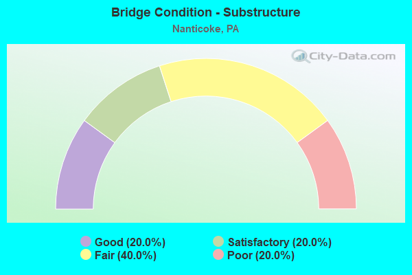
- Bridge Condition - Substructure
- 20.0%Good
- 20.0%Satisfactory
- 40.0%Fair
- 20.0%Poor
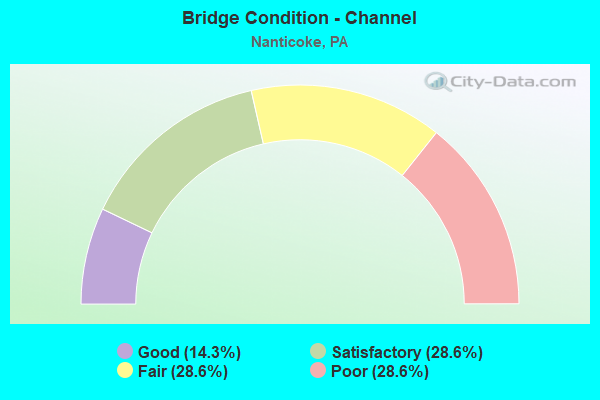
- Bridge Condition - Channel
- 14.3%Good
- 28.6%Satisfactory
- 28.6%Fair
- 28.6%Poor
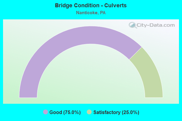
- Bridge Condition - Culverts
- 75.0%Good
- 25.0%Satisfactory
Find on map >> Show street view
Structure Number: 23623, Location: HANOVER TWP .6M S SR 2002 (Lat: 41.203431, Lng: -75.974656), Route carried "on" structure: State highway 29, Year Built: 1969, Year Reconstructed: 1989, Status: Open, Structure Length: 3.11m (10.20ft), Average Daily Traffic: 11,271 (year 2020), Truck Traffic: 8%, Average Future Daily Traffic: 20,532 (year 2032), Design Load: HS 20, Features Intersected: HAUL ROAD
Minimum Vertical Clearance: 30+ m (98+ ft), Kilometerpoint: 5.824, Lanes on structure: 2, Lanes under structure: 2, Base Highway Network: Yes, Owner: State Highway Agency, Approaching Roadway Width: 25.0m (82.0ft), Skew: 32 degrees, Material/Design: Prestressed concrete, Design/Construction: Box Beam or Girders - Single/Spread, Number Of Spans In Main Unit: 3, Length of Maximum Span: 9.8m (32.2ft), Curb or Sidewalk Widths: Left: 0.2m (0.7ft), Right: 0.2m (0.7ft), Curb-To-Curb Width: 25.3m (83.0ft), Out-to-Out Width: 26.7m (87.6ft)
Condition: Deck: Good, Superstructure: Fair, Substructure: Fair, Operating Rating: 47.2 metric tons, Method Used To Determine Operating Rating: Load Factor (LF), Inventory Rating: 28.1 metric tons, Method Used To Determine Inventory Rating: Load Factor (LF), Structural Evaluation: Somewhat better than minimum adequacy, Deck Geometry: Superior to present desirable criteria, Approach Roadway Alignment: Equal to present desirable criteria, Length Of Structure Improvement: 3.90m (12.80ft), Designated Inspection Frequency: Every 24 months, Inspection Date: November 2020, Bridge Improvement Cost: $49,000, Roadway Improvement Cost: $144,000, Total Project Cost: $662,000, Deck Structure Type: Concrete Cast-file-Place, Wearing Surface/Protective System: Wearing Surface: Monolithic Concrete, Deck Protection: Epoxy Coated Reinforcing
Find on map >> Show street view
Structure Number: 23624, Location: HANOVER TWP .2M S SR 2002 (Lat: 41.206122, Lng: -75.979133), Route carried "on" structure: State highway 29, Year Built: 1969, Status: Open, Structure Length: 0.91m (2.99ft), Average Daily Traffic: 15,931 (year 2020), Truck Traffic: 7%, Average Future Daily Traffic: 15,685 (year 2032), Design Load: HS 20, Features Intersected: NANTICOKE CREEK
Minimum Vertical Clearance: 30+ m (98+ ft), Kilometerpoint: 5.824, Lanes on structure: 5, Base Highway Network: Yes, Owner: State Highway Agency, Approaching Roadway Width: 27.1m (88.9ft), Skew: 31 degrees, Material/Design: Concrete, Design/Construction: Culvert, Number Of Spans In Main Unit: 1, Length of Maximum Span: 9.1m (29.9ft)
Condition: Channel: Satisfactory, Culverts: Good, Operating Rating: 49.0 metric tons, Method Used To Determine Operating Rating: Field evaluation and documented engineering judgment, Inventory Rating: 32.7 metric tons, Method Used To Determine Inventory Rating: Field evaluation and documented engineering judgment, Structural Evaluation: Better than present minimum criteria, Waterway Adequacy: Superior to present desirable criteria, Approach Roadway Alignment: Equal to present desirable criteria, Length Of Structure Improvement: 1.60m (5.25ft), Designated Inspection Frequency: Every 48 months, Inspection Date: November 2018
Find on map >> Show street view
Structure Number: 23625, Location: HANOVER TWP OVER SR 2002 (Lat: 41.208806, Lng: -75.981344), Route carried "on" structure: State highway 29, Year Built: 1969, Year Reconstructed: 2012, Status: Open, Structure Length: 6.71m (22.01ft), Average Daily Traffic: 9,591 (year 2020), Truck Traffic: 6%, Average Future Daily Traffic: 11,089 (year 2032), Design Load: HS 20, Features Intersected: SR 2002 SANS SOUCI HWY
Minimum Vertical Clearance: 30+ m (98+ ft), Kilometerpoint: 5.824, Lanes on structure: 4, Lanes under structure: 10, Base Highway Network: Yes, Owner: State Highway Agency, Approaching Roadway Width: 25.0m (82.0ft), Skew: 32 degrees, Material/Design: Steel, Design/Construction: Stringer/Multi-beam, Number Of Spans In Main Unit: 1, Number Of Approach Spans: 2, Length of Maximum Span: 36.0m (118.1ft), Curb or Sidewalk Widths: Left: 0.2m (0.7ft), Right: 0.2m (0.7ft), Curb-To-Curb Width: 24.2m (79.4ft), Out-to-Out Width: 25.5m (83.7ft)
Condition: Deck: Very good, Superstructure: Good, Substructure: Good, Operating Rating: 62.6 metric tons, Method Used To Determine Operating Rating: Load and Resistance Factor (LRFR), Inventory Rating: 48.1 metric tons, Method Used To Determine Inventory Rating: Load and Resistance Factor (LRFR), Structural Evaluation: Better than present minimum criteria, Deck Geometry: Superior to present desirable criteria, Underclear: Meets minimum limits, Approach Roadway Alignment: Equal to present desirable criteria, Length Of Structure Improvement: 6.70m (21.98ft), Designated Inspection Frequency: Every 48 months, Inspection Date: November 2018, Bridge Improvement Cost: $31,000, Roadway Improvement Cost: $100,000, Total Project Cost: $416,000, Deck Structure Type: Concrete Cast-file-Place, Wearing Surface/Protective System: Wearing Surface: Monolithic Concrete, Deck Protection: Epoxy Coated Reinforcing
Find on map >> Show street view
Structure Number: 23626, Location: HANOVER TWP JCT TR 11 (Lat: 41.209444, Lng: -75.982500), Route carried "on" structure: Spur State highway 29, Year Built: 1957, Year Reconstructed: 2009, Status: Open, Structure Length: 83.79m (274.90ft), Average Daily Traffic: 9,591 (year 2020), Truck Traffic: 6%, Average Future Daily Traffic: 11,089 (year 2032), Design Load: HS 20, Features Intersected: SUSQUEHANNA RIVER & R.R.
Minimum Vertical Clearance: 30+ m (98+ ft), Kilometerpoint: 6.780, Lanes on structure: 2, Base Highway Network: Yes, Owner: State Highway Agency, Approaching Roadway Width: 18.3m (60.0ft), Skew: 30 degrees, Material/Design: Steel continuous, Design/Construction: Girder and Floorbeam System, Number Of Spans In Main Unit: 16, Length of Maximum Span: 54.6m (179.1ft), Curb or Sidewalk Widths: Left: 0.2m (0.7ft), Right: 0.2m (0.7ft), Curb-To-Curb Width: 17.3m (56.8ft), Out-to-Out Width: 19.3m (63.3ft)
Condition: Deck: Satisfactory, Superstructure: Fair, Substructure: Satisfactory, Channel: Satisfactory, Operating Rating: 69.9 metric tons, Method Used To Determine Operating Rating: Load Factor (LF), Inventory Rating: 41.7 metric tons, Method Used To Determine Inventory Rating: Load Factor (LF), Structural Evaluation: Somewhat better than minimum adequacy, Deck Geometry: Superior to present desirable criteria, Underclear: High priority of corrective action, Waterway Adequacy: Superior to present desirable criteria, Approach Roadway Alignment: Equal to present desirable criteria, Length Of Structure Improvement: 85.00m (278.87ft), Designated Inspection Frequency: Every 24 months, Critical Feature Inspection Frequency: Every 24 months, Underwater Inspection Frequency: Every 60 months, Inspection Date: November 2020, Critical Feature Inspection Date: November 2020, Underwater Inspection Date: June 2020, Bridge Improvement Cost: $1,242,000, Roadway Improvement Cost: $3,659,000, Total Project Cost: $16,770,000, Deck Structure Type: Concrete Cast-file-Place, Wearing Surface/Protective System: Wearing Surface: Monolithic Concrete, Deck Protection: Epoxy Coated Reinforcing
Find on map >> Show street view
Structure Number: 24057, Location: HANOVER TWP .1 M S TR 29 (Lat: 41.208369, Lng: -75.985167), Route carried "on" structure: State highway , Year Built: 1955, Year Reconstructed: 1969, Status: Open, Structure Length: 0.94m (3.08ft), Average Daily Traffic: 14,836 (year 2022), Truck Traffic: 2%, Average Future Daily Traffic: 19,364 (year 2032), Design Load: HS 20, Features Intersected: NANTICOKE CREEK, Facility Carried by Structure: SR 2002
Minimum Vertical Clearance: 30+ m (98+ ft), Kilometerpoint: 1.664, Lanes on structure: 2, Base Highway Network: Yes, Owner: State Highway Agency, Approaching Roadway Width: 24.4m (80.1ft), Skew: 21 degrees, Material/Design: Concrete, Design/Construction: Tee Beam, Number Of Spans In Main Unit: 1, Length of Maximum Span: 9.1m (29.9ft), Curb or Sidewalk Widths: Left: 0.2m (0.7ft), Right: 0.2m (0.7ft), Curb-To-Curb Width: 34.1m (111.9ft), Out-to-Out Width: 35.4m (116.1ft)
Condition: Deck: Fair, Superstructure: Satisfactory, Substructure: Fair, Channel: Fair, Operating Rating: 48.1 metric tons, Method Used To Determine Operating Rating: Load Factor (LF), Inventory Rating: 29.0 metric tons, Method Used To Determine Inventory Rating: Load Factor (LF), Structural Evaluation: Somewhat better than minimum adequacy, Deck Geometry: Superior to present desirable criteria, Waterway Adequacy: Equal to present desirable criteria, Approach Roadway Alignment: Equal to present desirable criteria, Length Of Structure Improvement: 0.90m (2.95ft), Designated Inspection Frequency: Every 24 months, Inspection Date: Febuary 2021, Bridge Improvement Cost: $18,000, Roadway Improvement Cost: $100,000, Total Project Cost: $244,000, Deck Structure Type: Concrete Cast-file-Place, Wearing Surface/Protective System: Wearing Surface: Bituminous
Find on map >> Show street view
Structure Number: 24173, Location: NANTICKE BOR .3M N SR3002 (Lat: 41.197006, Lng: -76.012556), Route carried "on" structure: State highway , Year Built: 1961, Status: Open, Structure Length: 0.82m (2.69ft), Average Daily Traffic: 6,218 (year 2022), Truck Traffic: 3%, Average Future Daily Traffic: 9,788 (year 2033), Design Load: HS 20, Features Intersected: FORGE CREEK, Facility Carried by Structure: SR 3001 W MAIN ST
Minimum Vertical Clearance: 30+ m (98+ ft), Kilometerpoint: 5.562, Lanes on structure: 2, Owner: State Highway Agency, Approaching Roadway Width: 9.8m (32.2ft), Material/Design: Concrete, Design/Construction: Culvert, Number Of Spans In Main Unit: 1, Length of Maximum Span: 7.3m (24.0ft), Curb or Sidewalk Widths: Left: 0.2m (0.7ft), Right: 1.5m (4.9ft), Curb-To-Curb Width: 9.8m (32.2ft), Out-to-Out Width: 12.1m (39.7ft)
Condition: Channel: Fair, Culverts: Satisfactory, Operating Rating: 38.1 metric tons, Method Used To Determine Operating Rating: Load Factor (LF), Inventory Rating: 22.7 metric tons, Method Used To Determine Inventory Rating: Load Factor (LF), Structural Evaluation: Somewhat better than minimum adequacy, Deck Geometry: Meets minimum limits, Waterway Adequacy: Equal to present desirable criteria, Approach Roadway Alignment: Equal to present desirable criteria, Length Of Structure Improvement: 1.40m (4.59ft), Designated Inspection Frequency: Every 24 months, Inspection Date: January 2021, Wearing Surface/Protective System: Wearing Surface: Bituminous
Find on map >> Show street view
Structure Number: 24451, Location: AT US 11/PA29 INTERSECT. (Lat: 41.214972, Lng: -76.003381), Route carried "on" structure: County highway , Year Built: 1914, Year Reconstructed: 1987, Status: Posted for load, Structure Length: 58.58m (192.19ft), Average Daily Traffic: 9,300 (year 2011), Truck Traffic: 5%, Average Future Daily Traffic: 11,160 (year 2031), Features Intersected: SUSQUEHANNA RIVER, Facility Carried by Structure: BROADWAY STREET
Minimum Vertical Clearance: 4.52m (14.83ft), Kilometerpoint: 0.000, Lanes on structure: 2, Owner: County Highway Agency, Approaching Roadway Width: 6.4m (21.0ft), Material/Design: Steel, Design/Construction: Truss - Thru, Number Of Spans In Main Unit: 3, Number Of Approach Spans: 21, Length of Maximum Span: 91.4m (299.9ft), Curb or Sidewalk Widths: Left: 1.4m (4.6ft), Right: 0.2m (0.7ft), Curb-To-Curb Width: 6.4m (21.0ft), Out-to-Out Width: 6.7m (22.0ft)
Condition: Deck: Satisfactory, Superstructure: Poor, Substructure: Poor, Channel: Poor, Operating Rating: 25.4 metric tons, Method Used To Determine Operating Rating: Load Factor (LF), Inventory Rating: 14.5 metric tons, Method Used To Determine Inventory Rating: Load Factor (LF), Structural Evaluation: High priority of corrective action, Deck Geometry: High priority of replacement, Waterway Adequacy: Superior to present desirable criteria, Approach Roadway Alignment: Better than present minimum criteria, Bridge Posting: Required (Relationship of Operating Rating to Maximum Legal Load: 30.0 - 39.9% below), Length Of Structure Improvement: 58.80m (192.91ft), Designated Inspection Frequency: Every 24 months, Critical Feature Inspection Frequency: Every 12 months, Underwater Inspection Frequency: Every 24 months, Other Special Inspection Frequency: Every 6 months, Inspection Date: March 2021, Critical Feature Inspection Date: March 2021, Underwater Inspection Date: June 2021, Other Special Inspection Date: March 2021, Bridge Improvement Cost: $76,000, Roadway Improvement Cost: $223,000, Total Project Cost: $1,023,000, Deck Structure Type: Concrete Cast-file-Place, Wearing Surface/Protective System: Wearing Surface: Monolithic Concrete, Deck Protection: Epoxy Coated Reinforcing
Find on map >> Show street view
Structure Number: 42997, Location: 400 FT NE OF ALDEN RD (Lat: 41.195061, Lng: -76.010781), Route carried "on" structure: City street , Year Built: 2004, Status: Open, Structure Length: 0.73m (2.40ft), Average Daily Traffic: 1,500 (year 2021), Truck Traffic: 1%, Average Future Daily Traffic: 2,000 (year 2039), Features Intersected: S. BRANCH NEWPORT CREEK, Facility Carried by Structure: WEST UNION STREET
Minimum Vertical Clearance: 30+ m (98+ ft), Kilometerpoint: 0.000, Lanes on structure: 2, Toll: Toll bridge, Owner: City or Municipal Highway Agency, Approaching Roadway Width: 10.7m (35.1ft), Skew: 9 degrees, Material/Design: Concrete, Design/Construction: Culvert, Number Of Spans In Main Unit: 1, Length of Maximum Span: 7.3m (24.0ft), Curb or Sidewalk Widths: Left: 2.7m (8.9ft), Right: 3.0m (9.8ft), Curb-To-Curb Width: 10.7m (35.1ft), Out-to-Out Width: 18.0m (59.1ft)
Condition: Channel: Poor, Culverts: Good, Operating Rating: 92.5 metric tons, Method Used To Determine Operating Rating: Load Factor (LF), Inventory Rating: 55.3 metric tons, Method Used To Determine Inventory Rating: Load Factor (LF), Structural Evaluation: Better than present minimum criteria, Deck Geometry: Equal to present minimum criteria, Waterway Adequacy: High priority of corrective action, Approach Roadway Alignment: Equal to present desirable criteria, Designated Inspection Frequency: Every 24 months, Inspection Date: April 2021, Wearing Surface/Protective System: Wearing Surface: Monolithic Concrete, Deck Protection: Epoxy Coated Reinforcing
Find on map >> Show street view
Structure Number: 57611, Location: 1/4 MILE FROM MARKET ST (Lat: 41.206203, Lng: -76.009792), Route carried "on" structure: City street , Year Built: 1983, Status: Open, Structure Length: 0.61m (2.00ft), Average Daily Traffic: 150 (year 2020), Truck Traffic: 2%, Average Future Daily Traffic: 250 (year 2040), Features Intersected: NEWPORT CREEK, Facility Carried by Structure: INDUSTRIAL RD
Minimum Vertical Clearance: 30+ m (98+ ft), Kilometerpoint: 0.000, Lanes on structure: 2, Owner: City or Municipal Highway Agency, Approaching Roadway Width: 9.1m (29.9ft), Material/Design: Concrete, Design/Construction: Culvert, Number Of Spans In Main Unit: 1, Length of Maximum Span: 0.3m (1.0ft), Curb-To-Curb Width: 11.0m (36.1ft), Out-to-Out Width: 12.2m (40.0ft)
Condition: Channel: Good, Culverts: Good, Operating Rating: 81.6 metric tons, Method Used To Determine Operating Rating: Field evaluation and documented engineering judgment, Inventory Rating: 49.0 metric tons, Method Used To Determine Inventory Rating: Field evaluation and documented engineering judgment, Structural Evaluation: Better than present minimum criteria, Deck Geometry: Equal to present desirable criteria, Waterway Adequacy: Better than present minimum criteria, Approach Roadway Alignment: Equal to present desirable criteria, Designated Inspection Frequency: Every 24 months, Inspection Date: October 2020
Find on map >> Show street view
Structure Number: 23623, Location: HANOVER TWP .6M S SR 2002 (Lat: 41.203431, Lng: -75.974656), Route carried "under" structure: Other road , Year Built: 1969, Structure Length: 0. m, Features Intersected: HAUL ROAD, Facility Carried by Structure: SR 0029 TR 29
Minimum Vertical Clearance: 3.86m (12.66ft), Kilometerpoint: 0.000, Lanes on structure: 2, Lanes under structure: 2, Material/Design: Prestressed concrete, Design/Construction: Box Beam or Girders - Single/Spread, Length of Maximum Span: 9.8m (32.2ft)
Find on map >> Show street view
Structure Number: 23625, Location: HANOVER TWP OVER SR 2002 (Lat: 41.208806, Lng: -75.981344), Route carried "under" structure: State highway , Year Built: 1969, Structure Length: 0. m, Average Daily Traffic: 5,905 (year 2021), Truck Traffic: 6%, Features Intersected: SR 2002 SANS SOUCI HWY, Facility Carried by Structure: SR 0029 TR 29
Minimum Vertical Clearance: 5.33m (17.49ft), Kilometerpoint: 1.664, Lanes on structure: 4, Lanes under structure: 5, Material/Design: Steel, Design/Construction: Stringer/Multi-beam, Length of Maximum Span: 36.0m (118.1ft)
Find on map >> Show street view
Structure Number: 23625, Location: HANOVER TWP OVER SR 2002 (Lat: 41.208806, Lng: -75.981344), Route carried "under" structure: State highway , Year Built: 1969, Structure Length: 0. m, Average Daily Traffic: 5,600 (year 2021), Truck Traffic: 5%, Features Intersected: SR 2002 SANS SOUCI HWY, Facility Carried by Structure: SR 0029 TR 29
Minimum Vertical Clearance: 5.33m (17.49ft), Kilometerpoint: 1.664, Lanes on structure: 4, Lanes under structure: 5, Material/Design: Steel, Design/Construction: Stringer/Multi-beam, Length of Maximum Span: 36.0m (118.1ft)