Bridge Statistics for Napavine, Washington (WA)
Condition, Traffic, Stress, Structural Evaluation, Project Costs
- National Bridge Inventory (NBI) Statistics
- 33Number of bridges
- 394ft / 120mTotal length
- $54,684,000Total costs
- 306,506Total average daily traffic
- 55,839Total average daily truck traffic
- National Bridge Inventory (NBI) Registered Bridges for Napavine
- No street view available for this location
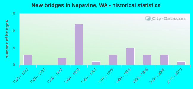
- New bridges - historical statistics
- 31920-1929
- 21940-1949
- 121950-1959
- 11960-1969
- 31970-1979
- 51980-1989
- 31990-1999
- 32000-2009
- 12010-2019


- Bridge Condition - Deck
- 25.0%Very good
- 46.4%Good
- 25.0%Satisfactory
- 3.6%Fair

- Bridge Condition - Superstructure
- 28.6%Very good
- 35.7%Good
- 17.9%Satisfactory
- 14.3%Fair
- 3.6%Poor

- Bridge Condition - Substructure
- 25.0%Very good
- 53.6%Good
- 14.3%Satisfactory
- 7.1%Fair

- Bridge Condition - Channel
- 56.0%Very good
- 32.0%Good
- 4.0%Satisfactory
- 8.0%Fair
Find on map >> Show street view
Structure Number: 4204A, Location: 1.2 N JCT SR 508 (Lat: 46.598111, Lng: -122.901806), Route carried "on" structure: Interstate 5, Year Built: 1952, Year Reconstructed: 1976, Status: Open, Structure Length: 8.66m (28.41ft), Average Daily Traffic: 29,641 (year 2019), Truck Traffic: 19%, Average Future Daily Traffic: 38,177 (year 2039), Design Load: HS 20, Features Intersected: NEWAUKUM RIVER
Minimum Vertical Clearance: 30+ m (98+ ft), Kilometerpoint: 116.243, Lanes on structure: 2, Base Highway Network: Yes, Owner: State Highway Agency, Approaching Roadway Width: 11.0m (36.1ft), Skew: 1 degrees, Material/Design: Concrete continuous, Design/Construction: Tee Beam, Number Of Spans In Main Unit: 5, Length of Maximum Span: 27.4m (89.9ft), Curb-To-Curb Width: 11.1m (36.4ft), Out-to-Out Width: 12.0m (39.4ft)
Condition: Deck: Satisfactory, Superstructure: Fair, Substructure: Good, Channel: Fair, Operating Rating: 25.3 metric tons, Method Used To Determine Operating Rating: Load and Resistance Factor Rating (LRFR) rating reported by rating factor(RF) method using HL-93 loadings, Inventory Rating: 19.4 metric tons, Method Used To Determine Inventory Rating: Load and Resistance Factor Rating (LRFR) rating reported by rating factor(RF) method using HL-93 loadings, Structural Evaluation: Meets minimum limits, Deck Geometry: Somewhat better than minimum adequacy, Waterway Adequacy: Equal to present desirable criteria, Approach Roadway Alignment: Equal to present desirable criteria, Length Of Structure Improvement: 8.66m (28.41ft), Designated Inspection Frequency: Every 24 months, Inspection Date: October 2020, Bridge Improvement Cost: $2,158,000, Roadway Improvement Cost: $432,000, Total Project Cost: $4,317,000 ( Estimate for 2014), Deck Structure Type: Concrete Cast-file-Place, Wearing Surface/Protective System: Wearing Surface: Bituminous, Membrane: Preformed Fabric
Find on map >> Show street view
Structure Number: 4204B, Location: 1.2 N JCT SR 508 (Lat: 46.598056, Lng: -122.902056), Route carried "on" structure: Interstate 5, Year Built: 1952, Year Reconstructed: 1976, Status: Open, Structure Length: 8.66m (28.41ft), Average Daily Traffic: 29,641 (year 2019), Truck Traffic: 19%, Average Future Daily Traffic: 38,177 (year 2039), Design Load: HS 20, Features Intersected: NEWAUKUM RIVER
Minimum Vertical Clearance: 30+ m (98+ ft), Kilometerpoint: 116.243, Lanes on structure: 2, Base Highway Network: Yes, Owner: State Highway Agency, Approaching Roadway Width: 11.0m (36.1ft), Skew: 1 degrees, Material/Design: Concrete continuous, Design/Construction: Tee Beam, Number Of Spans In Main Unit: 5, Length of Maximum Span: 27.4m (89.9ft), Curb-To-Curb Width: 11.1m (36.4ft), Out-to-Out Width: 12.0m (39.4ft)
Condition: Deck: Satisfactory, Superstructure: Satisfactory, Substructure: Good, Channel: Fair, Operating Rating: 25.3 metric tons, Method Used To Determine Operating Rating: Load and Resistance Factor Rating (LRFR) rating reported by rating factor(RF) method using HL-93 loadings, Inventory Rating: 19.4 metric tons, Method Used To Determine Inventory Rating: Load and Resistance Factor Rating (LRFR) rating reported by rating factor(RF) method using HL-93 loadings, Structural Evaluation: Meets minimum limits, Deck Geometry: Somewhat better than minimum adequacy, Waterway Adequacy: Equal to present desirable criteria, Approach Roadway Alignment: Equal to present desirable criteria, Length Of Structure Improvement: 8.66m (28.41ft), Designated Inspection Frequency: Every 24 months, Inspection Date: October 2020, Bridge Improvement Cost: $2,158,000, Roadway Improvement Cost: $432,000, Total Project Cost: $4,317,000 ( Estimate for 2014), Deck Structure Type: Concrete Cast-file-Place, Wearing Surface/Protective System: Wearing Surface: Bituminous, Membrane: Preformed Fabric
Find on map >> Show street view
Structure Number: 4363A, Location: 1.7 N JCT SR 508 (Lat: 46.605389, Lng: -122.906639), Route carried "on" structure: Interstate 5, Year Built: 1953, Year Reconstructed: 1975, Status: Open, Structure Length: 4.30m (14.11ft), Average Daily Traffic: 26,152 (year 2019), Truck Traffic: 19%, Average Future Daily Traffic: 33,683 (year 2039), Design Load: HS 20, Features Intersected: RUSH RD
Minimum Vertical Clearance: 30+ m (98+ ft), Kilometerpoint: 117.128, Lanes on structure: 2, Lanes under structure: 2, Base Highway Network: Yes, Owner: State Highway Agency, Approaching Roadway Width: 11.6m (38.1ft), Material/Design: Concrete continuous, Design/Construction: Tee Beam, Number Of Spans In Main Unit: 4, Length of Maximum Span: 12.5m (41.0ft), Curb-To-Curb Width: 11.6m (38.1ft), Out-to-Out Width: 12.5m (41.0ft)
Condition: Deck: Good, Superstructure: Fair, Substructure: Satisfactory, Operating Rating: 48.1 metric tons, Method Used To Determine Operating Rating: Load Factor (LF), Inventory Rating: 29.0 metric tons, Method Used To Determine Inventory Rating: Load Factor (LF), Structural Evaluation: Somewhat better than minimum adequacy, Deck Geometry: Equal to present minimum criteria, Underclear: Meets minimum limits, Approach Roadway Alignment: Equal to present desirable criteria, Length Of Structure Improvement: 4.30m (14.11ft), Designated Inspection Frequency: Every 24 months, Inspection Date: March 2020, Bridge Improvement Cost: $1,128,000, Roadway Improvement Cost: $226,000, Total Project Cost: $2,256,000 ( Estimate for 2014), Deck Structure Type: Concrete Cast-file-Place, Wearing Surface/Protective System: Wearing Surface: Bituminous, Membrane: Preformed Fabric
Find on map >> Show street view
Structure Number: 4363B, Location: 1.7 N JCT SR 508 (Lat: 46.605306, Lng: -122.906889), Route carried "on" structure: Interstate 5, Year Built: 1953, Year Reconstructed: 1975, Status: Open, Structure Length: 4.30m (14.11ft), Average Daily Traffic: 26,152 (year 2019), Truck Traffic: 19%, Average Future Daily Traffic: 33,683 (year 2039), Design Load: HS 20, Features Intersected: RUSH RD
Minimum Vertical Clearance: 30+ m (98+ ft), Kilometerpoint: 117.128, Lanes on structure: 2, Lanes under structure: 2, Base Highway Network: Yes, Owner: State Highway Agency, Approaching Roadway Width: 11.6m (38.1ft), Material/Design: Concrete continuous, Design/Construction: Tee Beam, Number Of Spans In Main Unit: 4, Length of Maximum Span: 12.5m (41.0ft), Curb-To-Curb Width: 11.6m (38.1ft), Out-to-Out Width: 12.5m (41.0ft)
Condition: Deck: Satisfactory, Superstructure: Fair, Substructure: Good, Operating Rating: 48.1 metric tons, Method Used To Determine Operating Rating: Load Factor (LF), Inventory Rating: 29.0 metric tons, Method Used To Determine Inventory Rating: Load Factor (LF), Structural Evaluation: Somewhat better than minimum adequacy, Deck Geometry: Equal to present minimum criteria, Underclear: Meets minimum limits, Approach Roadway Alignment: Equal to present desirable criteria, Length Of Structure Improvement: 4.30m (14.11ft), Designated Inspection Frequency: Every 24 months, Inspection Date: March 2020, Bridge Improvement Cost: $1,128,000, Roadway Improvement Cost: $226,000, Total Project Cost: $2,256,000 ( Estimate for 2014), Deck Structure Type: Concrete Cast-file-Place, Wearing Surface/Protective System: Wearing Surface: Bituminous, Membrane: Preformed Fabric
Find on map >> Show street view
Structure Number: 5678A, Location: JCT I-5 (Lat: 46.547367, Lng: -122.877056), Route carried "on" structure: US 12, Year Built: 1958, Status: Open, Structure Length: 6.25m (20.51ft), Average Daily Traffic: 7,628 (year 2019), Truck Traffic: 16%, Average Future Daily Traffic: 9,824 (year 2039), Design Load: HS 20, Features Intersected: I-5
Minimum Vertical Clearance: 30+ m (98+ ft), Kilometerpoint: 107.086, Lanes on structure: 2, Lanes under structure: 5, Base Highway Network: Yes, Owner: State Highway Agency, Approaching Roadway Width: 11.6m (38.1ft), Material/Design: Prestressed concrete, Design/Construction: Stringer/Multi-beam, Number Of Spans In Main Unit: 4, Length of Maximum Span: 19.8m (65.0ft), Curb-To-Curb Width: 8.7m (28.5ft), Out-to-Out Width: 9.6m (31.5ft)
Condition: Deck: Good, Superstructure: Satisfactory, Substructure: Good, Operating Rating: 56.2 metric tons, Method Used To Determine Operating Rating: Load Factor (LF), Inventory Rating: 32.7 metric tons, Method Used To Determine Inventory Rating: Load Factor (LF), Structural Evaluation: Equal to present minimum criteria, Deck Geometry: Meets minimum limits, Underclear: High priority of corrective action, Approach Roadway Alignment: Equal to present desirable criteria, Length Of Structure Improvement: 6.25m (20.51ft), Designated Inspection Frequency: Every 24 months, Inspection Date: November 2021, Bridge Improvement Cost: $1,640,000, Roadway Improvement Cost: $328,000, Total Project Cost: $3,280,000 ( Estimate for 2014), Deck Structure Type: Concrete Cast-file-Place, Wearing Surface/Protective System: Wearing Surface: Bituminous, Membrane: Preformed Fabric
Find on map >> Show street view
Structure Number: 10173A, Location: 1.0 N JCT US 12 (Lat: 46.561694, Lng: -122.876917), Route carried "on" structure: County highway , Year Built: 1976, Status: Open, Structure Length: 5.06m (16.60ft), Average Daily Traffic: 603 (year 2011), Truck Traffic: 10%, Average Future Daily Traffic: 829 (year 2036), Design Load: HS 20+Mod, Features Intersected: I-5, Facility Carried by Structure: KOONTZ RD
Minimum Vertical Clearance: 30+ m (98+ ft), Kilometerpoint: 0.724, Lanes on structure: 2, Lanes under structure: 5, Owner: State Highway Agency, Approaching Roadway Width: 8.5m (27.9ft), Material/Design: Prestressed concrete continuous, Design/Construction: Stringer/Multi-beam, Number Of Spans In Main Unit: 2, Length of Maximum Span: 24.4m (80.1ft), Curb-To-Curb Width: 8.5m (27.9ft), Out-to-Out Width: 9.4m (30.8ft)
Condition: Deck: Good, Superstructure: Poor, Substructure: Good, Operating Rating: 75.3 metric tons, Method Used To Determine Operating Rating: Load Factor (LF), Inventory Rating: 44.4 metric tons, Method Used To Determine Inventory Rating: Load Factor (LF), Structural Evaluation: Meets minimum limits, Deck Geometry: Somewhat better than minimum adequacy, Underclear: High priority of corrective action, Approach Roadway Alignment: Equal to present desirable criteria, Length Of Structure Improvement: 5.06m (16.60ft), Designated Inspection Frequency: Every 24 months, Inspection Date: August 2020, Bridge Improvement Cost: $996,000, Roadway Improvement Cost: $199,000, Total Project Cost: $1,992,000 ( Estimate for 2014), Deck Structure Type: Concrete Cast-file-Place, Wearing Surface/Protective System: Wearing Surface: Monolithic Concrete
Find on map >> Show street view
Structure Number: 13015A, Location: JCT I-5 (Lat: 46.583667, Lng: -122.889028), Route carried "on" structure: State highway 508, Year Built: 1986, Status: Open, Structure Length: 7.62m (25.00ft), Average Daily Traffic: 4,213 (year 2019), Truck Traffic: 9%, Average Future Daily Traffic: 5,426 (year 2039), Design Load: HS 20+Mod, Features Intersected: I-5
Minimum Vertical Clearance: 30+ m (98+ ft), Kilometerpoint: 0.001, Lanes on structure: 2, Lanes under structure: 4, Owner: State Highway Agency, Approaching Roadway Width: 12.2m (40.0ft), Skew: 3 degrees, Material/Design: Prestressed concrete continuous, Design/Construction: Stringer/Multi-beam, Number Of Spans In Main Unit: 2, Length of Maximum Span: 38.1m (125.0ft), Curb-To-Curb Width: 12.2m (40.0ft), Out-to-Out Width: 13.1m (43.0ft)
Condition: Deck: Good, Superstructure: Good, Substructure: Good, Operating Rating: 73.5 metric tons, Method Used To Determine Operating Rating: Load Factor (LF), Inventory Rating: 43.5 metric tons, Method Used To Determine Inventory Rating: Load Factor (LF), Structural Evaluation: Better than present minimum criteria, Deck Geometry: Equal to present minimum criteria, Underclear: Meets minimum limits, Approach Roadway Alignment: Equal to present desirable criteria, Length Of Structure Improvement: 7.62m (25.00ft), Designated Inspection Frequency: Every 48 months, Inspection Date: June 2018, Bridge Improvement Cost: $2,100,000, Roadway Improvement Cost: $420,000, Total Project Cost: $4,200,000 ( Estimate for 2014), Deck Structure Type: Concrete Cast-file-Place, Wearing Surface/Protective System: Wearing Surface: Monolithic Concrete, Deck Protection: Epoxy Coated Reinforcing
Find on map >> Show street view
Structure Number: 13425A, Location: 2.6 E JCT I-5 (Lat: 46.576083, Lng: -122.836944), Route carried "on" structure: State highway 508, Year Built: 1989, Status: Open, Structure Length: 9.75m (31.99ft), Average Daily Traffic: 4,595 (year 2019), Truck Traffic: 6%, Average Future Daily Traffic: 5,918 (year 2039), Design Load: HS 20+Mod, Features Intersected: S FORK NEWAUKUM RIVER
Minimum Vertical Clearance: 30+ m (98+ ft), Kilometerpoint: 4.136, Lanes on structure: 2, Owner: State Highway Agency, Approaching Roadway Width: 9.8m (32.2ft), Skew: 3 degrees, Material/Design: Prestressed concrete continuous, Design/Construction: Stringer/Multi-beam, Number Of Spans In Main Unit: 3, Length of Maximum Span: 32.6m (107.0ft), Curb-To-Curb Width: 10.0m (32.8ft), Out-to-Out Width: 10.9m (35.8ft)
Condition: Deck: Good, Superstructure: Good, Substructure: Good, Channel: Good, Operating Rating: 58.0 metric tons, Method Used To Determine Operating Rating: Load Factor (LF), Inventory Rating: 34.5 metric tons, Method Used To Determine Inventory Rating: Load Factor (LF), Structural Evaluation: Better than present minimum criteria, Deck Geometry: Meets minimum limits, Waterway Adequacy: Equal to present desirable criteria, Approach Roadway Alignment: Equal to present desirable criteria, Length Of Structure Improvement: 9.75m (31.99ft), Designated Inspection Frequency: Every 24 months, Inspection Date: March 2021, Bridge Improvement Cost: $2,176,000, Roadway Improvement Cost: $435,000, Total Project Cost: $4,352,000 ( Estimate for 2014), Deck Structure Type: Concrete Cast-file-Place, Wearing Surface/Protective System: Wearing Surface: Monolithic Concrete, Deck Protection: Epoxy Coated Reinforcing
Find on map >> Show street view
Structure Number: 81313, Location: 4.55 N JCT SR 505 (Lat: 46.543694, Lng: -122.886500), Route carried "on" structure: County highway 30062, Year Built: 1995, Status: Open, Structure Length: 1.22m (4.00ft), Average Daily Traffic: 2,151 (year 2018), Truck Traffic: 12%, Average Future Daily Traffic: 3,885 (year 2038), Design Load: HS 20, Features Intersected: OLEQUA CREEK, Facility Carried by Structure: NORTH MILITARY RD.
Minimum Vertical Clearance: 30+ m (98+ ft), Kilometerpoint: 0.001, Lanes on structure: 2, Owner: County Highway Agency, Approaching Roadway Width: 7.3m (24.0ft), Material/Design: Prestressed concrete, Design/Construction: Channel Beam, Number Of Spans In Main Unit: 1, Length of Maximum Span: 11.6m (38.1ft), Curb-To-Curb Width: 10.4m (34.1ft), Out-to-Out Width: 11.3m (37.1ft)
Condition: Deck: Very good, Superstructure: Very good, Substructure: Very good, Channel: Very good, Operating Rating: 58.0 metric tons, Method Used To Determine Operating Rating: Load Factor (LF) rating reported by rating factor (RF) method using MS18 loading, Inventory Rating: 34.7 metric tons, Method Used To Determine Inventory Rating: Load Factor (LF) rating reported by rating factor (RF) method using MS18 loading, Structural Evaluation: Equal to present desirable criteria, Deck Geometry: Somewhat better than minimum adequacy, Waterway Adequacy: Equal to present desirable criteria, Approach Roadway Alignment: Equal to present desirable criteria, Length Of Structure Improvement: 1.52m (4.99ft), Designated Inspection Frequency: Every 24 months, Inspection Date: December 2020, Bridge Improvement Cost: $760,000, Roadway Improvement Cost: $152,000, Total Project Cost: $1,520,000 ( Estimate for 2014), Deck Structure Type: Concrete Cast-file-Place, Wearing Surface/Protective System: Wearing Surface: Monolithic Concrete, Deck Protection: Epoxy Coated Reinforcing
Find on map >> Show street view
Structure Number: 81534, Location: 2.5 NE NAPAVINE (Lat: 46.612369, Lng: -122.869050), Route carried "on" structure: County highway 40038, Year Built: 1954, Status: Open, Structure Length: 0.91m (2.99ft), Average Daily Traffic: 100 (year 2017), Truck Traffic: 13%, Average Future Daily Traffic: 181 (year 2037), Features Intersected: BRANCH NEWAUKUM RIVER, Facility Carried by Structure: TAYLOR ROAD
Minimum Vertical Clearance: 30+ m (98+ ft), Kilometerpoint: 0.001, Lanes on structure: 2, Owner: County Highway Agency, Approaching Roadway Width: 6.1m (20.0ft), Material/Design: Concrete, Design/Construction: Stringer/Multi-beam, Number Of Spans In Main Unit: 1, Length of Maximum Span: 8.5m (27.9ft), Curb-To-Curb Width: 6.2m (20.3ft), Out-to-Out Width: 6.7m (22.0ft)
Condition: Deck: Good, Superstructure: Very good, Substructure: Good, Channel: Good, Operating Rating: 57.1 metric tons, Method Used To Determine Operating Rating: Load Factor (LF), Inventory Rating: 34.5 metric tons, Method Used To Determine Inventory Rating: Load Factor (LF), Structural Evaluation: Better than present minimum criteria, Deck Geometry: Somewhat better than minimum adequacy, Waterway Adequacy: Equal to present desirable criteria, Approach Roadway Alignment: Equal to present desirable criteria, Length Of Structure Improvement: 0.91m (2.99ft), Designated Inspection Frequency: Every 24 months, Inspection Date: Febuary 2020, Bridge Improvement Cost: $132,000, Roadway Improvement Cost: $26,000, Total Project Cost: $264,000 ( Estimate for 2014), Deck Structure Type: Concrete Cast-file-Place, Wearing Surface/Protective System: Wearing Surface: Bituminous
Find on map >> Show street view
Structure Number: 81614, Location: 2.56 N JCT SR 508 (Lat: 46.606050, Lng: -122.869967), Route carried "on" structure: County highway 94000, Year Built: 1926, Year Reconstructed: 1978, Status: Open, Structure Length: 2.50m (8.20ft), Average Daily Traffic: 3,427 (year 2019), Truck Traffic: 13%, Average Future Daily Traffic: 5,829 (year 2039), Design Load: HS 20, Features Intersected: NEWAUKUM OVERFLOW, Facility Carried by Structure: JACKSON HWY
Minimum Vertical Clearance: 30+ m (98+ ft), Kilometerpoint: 0.001, Lanes on structure: 2, Owner: County Highway Agency, Approaching Roadway Width: 11.0m (36.1ft), Material/Design: Concrete continuous, Design/Construction: Tee Beam, Number Of Spans In Main Unit: 3, Length of Maximum Span: 8.2m (26.9ft), Curb-To-Curb Width: 11.0m (36.1ft), Out-to-Out Width: 11.9m (39.0ft)
Condition: Deck: Satisfactory, Superstructure: Fair, Substructure: Fair, Channel: Very good, Operating Rating: 66.2 metric tons, Method Used To Determine Operating Rating: Load Factor (LF), Inventory Rating: 39.9 metric tons, Method Used To Determine Inventory Rating: Load Factor (LF), Structural Evaluation: Somewhat better than minimum adequacy, Deck Geometry: Somewhat better than minimum adequacy, Waterway Adequacy: Better than present minimum criteria, Approach Roadway Alignment: Equal to present desirable criteria, Length Of Structure Improvement: 2.50m (8.20ft), Designated Inspection Frequency: Every 24 months, Inspection Date: Febuary 2021, Bridge Improvement Cost: $623,000, Roadway Improvement Cost: $125,000, Total Project Cost: $1,246,000 ( Estimate for 2014), Deck Structure Type: Concrete Cast-file-Place, Wearing Surface/Protective System: Wearing Surface: Bituminous
Find on map >> Show street view
Structure Number: 81616, Location: 2.49 N JCT SR 508 (Lat: 46.605722, Lng: -122.869042), Route carried "on" structure: County highway 94000, Year Built: 1926, Year Reconstructed: 1978, Status: Open, Structure Length: 2.50m (8.20ft), Average Daily Traffic: 3,427 (year 2019), Truck Traffic: 13%, Average Future Daily Traffic: 6,190 (year 2039), Design Load: HS 20, Features Intersected: NEWAUKUM OVERFLOW, Facility Carried by Structure: JACKSON HWY.
Minimum Vertical Clearance: 30+ m (98+ ft), Kilometerpoint: 0.001, Lanes on structure: 2, Owner: County Highway Agency, Approaching Roadway Width: 11.0m (36.1ft), Material/Design: Concrete continuous, Design/Construction: Tee Beam, Number Of Spans In Main Unit: 3, Length of Maximum Span: 8.2m (26.9ft), Curb-To-Curb Width: 11.0m (36.1ft), Out-to-Out Width: 11.9m (39.0ft)
Condition: Deck: Good, Superstructure: Satisfactory, Substructure: Satisfactory, Channel: Very good, Operating Rating: 66.2 metric tons, Method Used To Determine Operating Rating: Load Factor (LF), Inventory Rating: 39.9 metric tons, Method Used To Determine Inventory Rating: Load Factor (LF), Structural Evaluation: Equal to present minimum criteria, Deck Geometry: Somewhat better than minimum adequacy, Waterway Adequacy: Better than present minimum criteria, Approach Roadway Alignment: Equal to present desirable criteria, Length Of Structure Improvement: 2.50m (8.20ft), Designated Inspection Frequency: Every 24 months, Inspection Date: Febuary 2021, Bridge Improvement Cost: $623,000, Roadway Improvement Cost: $125,000, Total Project Cost: $1,246,000 ( Estimate for 2014), Deck Structure Type: Concrete Cast-file-Place, Wearing Surface/Protective System: Wearing Surface: Bituminous
Find on map >> Show street view
Structure Number: 81685, Location: 2.0 SE CHEHALIS (Lat: 46.605078, Lng: -122.899181), Route carried "on" structure: County highway 40017, Year Built: 1973, Status: Open, Structure Length: 6.80m (22.31ft), Average Daily Traffic: 674 (year 2018), Truck Traffic: 14%, Average Future Daily Traffic: 1,218 (year 2038), Design Load: HS 20, Features Intersected: NEWAUKUM RIVER, Facility Carried by Structure: KIRKLAND ROAD
Minimum Vertical Clearance: 30+ m (98+ ft), Kilometerpoint: 0.001, Lanes on structure: 2, Owner: County Highway Agency, Approaching Roadway Width: 10.4m (34.1ft), Material/Design: Prestressed concrete, Design/Construction: Stringer/Multi-beam, Number Of Spans In Main Unit: 1, Number Of Approach Spans: 6, Length of Maximum Span: 27.4m (89.9ft), Curb or Sidewalk Widths: Left: 0.0m, Right: 0.9m (3.0ft), Curb-To-Curb Width: 8.5m (27.9ft), Out-to-Out Width: 10.3m (33.8ft)
Condition: Deck: Fair, Superstructure: Good, Substructure: Good, Channel: Good, Operating Rating: 59.9 metric tons, Method Used To Determine Operating Rating: Load Factor (LF), Inventory Rating: 35.4 metric tons, Method Used To Determine Inventory Rating: Load Factor (LF), Structural Evaluation: Better than present minimum criteria, Deck Geometry: Somewhat better than minimum adequacy, Waterway Adequacy: Somewhat better than minimum adequacy, Approach Roadway Alignment: Equal to present desirable criteria, Length Of Structure Improvement: 6.80m (22.31ft), Designated Inspection Frequency: Every 24 months, Inspection Date: Febuary 2021, Bridge Improvement Cost: $1,606,000, Roadway Improvement Cost: $321,000, Total Project Cost: $3,211,000 ( Estimate for 2014), Deck Structure Type: Concrete Cast-file-Place, Wearing Surface/Protective System: Wearing Surface: Monolithic Concrete
Find on map >> Show street view
Structure Number: 82075, Location: 2.0 E FOREST (Lat: 46.611625, Lng: -122.820753), Route carried "on" structure: County highway 45016, Year Built: 1991, Status: Open, Structure Length: 3.75m (12.30ft), Average Daily Traffic: 114 (year 2020), Truck Traffic: 12%, Average Future Daily Traffic: 206 (year 2040), Design Load: HS 20, Features Intersected: N FK NEWAUKUM RIVER, Facility Carried by Structure: TAUSCHER ROAD
Minimum Vertical Clearance: 30+ m (98+ ft), Kilometerpoint: 0.001, Lanes on structure: 2, Owner: County Highway Agency, Approaching Roadway Width: 7.6m (24.9ft), Material/Design: Prestressed concrete, Design/Construction: Stringer/Multi-beam, Number Of Spans In Main Unit: 2, Length of Maximum Span: 25.6m (84.0ft), Curb-To-Curb Width: 8.5m (27.9ft), Out-to-Out Width: 9.5m (31.2ft)
Condition: Deck: Very good, Superstructure: Very good, Substructure: Very good, Channel: Good, Operating Rating: 48.1 metric tons, Method Used To Determine Operating Rating: Load Factor (LF), Inventory Rating: 29.0 metric tons, Method Used To Determine Inventory Rating: Load Factor (LF), Structural Evaluation: Better than present minimum criteria, Deck Geometry: Equal to present minimum criteria, Waterway Adequacy: Equal to present desirable criteria, Approach Roadway Alignment: Equal to present minimum criteria, Length Of Structure Improvement: 3.75m (12.30ft), Designated Inspection Frequency: Every 24 months, Inspection Date: January 2021, Bridge Improvement Cost: $664,000, Roadway Improvement Cost: $133,000, Total Project Cost: $1,328,000 ( Estimate for 2014), Deck Structure Type: Concrete Cast-file-Place, Wearing Surface/Protective System: Wearing Surface: Monolithic Concrete
Find on map >> Show street view
Structure Number: 82469, Location: 0.34 NE 94000 (Lat: 46.603256, Lng: -122.855219), Route carried "on" structure: County highway 46000, Year Built: 1958, Status: Open, Structure Length: 6.22m (20.41ft), Average Daily Traffic: 1,016 (year 2017), Truck Traffic: 6%, Average Future Daily Traffic: 1,835 (year 2037), Design Load: HS 15, Features Intersected: S. FORK NEWAUKUM RIVER, Facility Carried by Structure: NORTH FORK RD.
Minimum Vertical Clearance: 30+ m (98+ ft), Kilometerpoint: 0.001, Lanes on structure: 2, Owner: County Highway Agency, Approaching Roadway Width: 7.3m (24.0ft), Material/Design: Concrete continuous, Design/Construction: Tee Beam, Number Of Spans In Main Unit: 3, Length of Maximum Span: 25.6m (84.0ft), Curb-To-Curb Width: 7.3m (24.0ft), Out-to-Out Width: 8.1m (26.6ft)
Condition: Deck: Satisfactory, Superstructure: Good, Substructure: Good, Channel: Very good, Operating Rating: 27.2 metric tons, Method Used To Determine Operating Rating: Load Factor (LF), Inventory Rating: 16.3 metric tons, Method Used To Determine Inventory Rating: Load Factor (LF), Structural Evaluation: Meets minimum limits, Deck Geometry: Meets minimum limits, Waterway Adequacy: Better than present minimum criteria, Approach Roadway Alignment: Equal to present desirable criteria, Length Of Structure Improvement: 6.22m (20.41ft), Designated Inspection Frequency: Every 24 months, Inspection Date: Febuary 2020, Bridge Improvement Cost: $1,061,000, Roadway Improvement Cost: $212,000, Total Project Cost: $2,122,000 ( Estimate for 2014), Deck Structure Type: Concrete Cast-file-Place, Wearing Surface/Protective System: Wearing Surface: Monolithic Concrete
Find on map >> Show street view
Structure Number: 82642, Location: 0.4 E JCT 94000 (Lat: 46.590556, Lng: -122.841667), Route carried "on" structure: County highway 45011, Year Built: 1956, Status: Open, Structure Length: 4.82m (15.81ft), Average Daily Traffic: 1,203 (year 2017), Truck Traffic: 16%, Average Future Daily Traffic: 2,173 (year 2037), Design Load: HS 15, Features Intersected: S. FORK NEWAUKUM RIVER, Facility Carried by Structure: MIDDLE FORK RD.
Minimum Vertical Clearance: 30+ m (98+ ft), Kilometerpoint: 0.001, Lanes on structure: 2, Owner: County Highway Agency, Approaching Roadway Width: 7.9m (25.9ft), Material/Design: Concrete continuous, Design/Construction: Tee Beam, Number Of Spans In Main Unit: 2, Length of Maximum Span: 21.3m (69.9ft), Curb-To-Curb Width: 7.3m (24.0ft), Out-to-Out Width: 8.1m (26.6ft)
Condition: Deck: Good, Superstructure: Good, Substructure: Good, Channel: Good, Operating Rating: 30.8 metric tons, Method Used To Determine Operating Rating: Load Factor (LF), Inventory Rating: 18.1 metric tons, Method Used To Determine Inventory Rating: Load Factor (LF), Structural Evaluation: Somewhat better than minimum adequacy, Deck Geometry: Meets minimum limits, Waterway Adequacy: Equal to present desirable criteria, Approach Roadway Alignment: Equal to present desirable criteria, Length Of Structure Improvement: 4.82m (15.81ft), Designated Inspection Frequency: Every 24 months, Inspection Date: Febuary 2020, Bridge Improvement Cost: $885,000, Roadway Improvement Cost: $177,000, Total Project Cost: $1,770,000 ( Estimate for 2014), Deck Structure Type: Concrete Cast-file-Place, Wearing Surface/Protective System: Wearing Surface: Monolithic Concrete
Find on map >> Show street view
Structure Number: 82854, Location: 2.0 E FOREST (Lat: 46.602236, Lng: -122.819178), Route carried "on" structure: County highway 45016, Year Built: 1951, Status: Open, Structure Length: 1.49m (4.89ft), Average Daily Traffic: 202 (year 2019), Truck Traffic: 23%, Average Future Daily Traffic: 365 (year 2039), Features Intersected: MID FK NEWAUKUM RIVER, Facility Carried by Structure: TAUSCHER ROAD
Minimum Vertical Clearance: 30+ m (98+ ft), Kilometerpoint: 0.001, Lanes on structure: 2, Owner: County Highway Agency, Approaching Roadway Width: 7.9m (25.9ft), Skew: 2 degrees, Material/Design: Concrete, Design/Construction: Stringer/Multi-beam, Number Of Spans In Main Unit: 2, Length of Maximum Span: 9.1m (29.9ft), Curb-To-Curb Width: 7.3m (24.0ft), Out-to-Out Width: 8.2m (26.9ft)
Condition: Deck: Satisfactory, Superstructure: Good, Substructure: Satisfactory, Channel: Good, Operating Rating: 95.3 metric tons, Method Used To Determine Operating Rating: Load Factor (LF) rating reported by rating factor (RF) method using MS18 loading, Inventory Rating: 57.0 metric tons, Method Used To Determine Inventory Rating: Load Factor (LF) rating reported by rating factor (RF) method using MS18 loading, Structural Evaluation: Equal to present minimum criteria, Deck Geometry: Somewhat better than minimum adequacy, Waterway Adequacy: Better than present minimum criteria, Approach Roadway Alignment: Equal to present desirable criteria, Length Of Structure Improvement: 1.49m (4.89ft), Designated Inspection Frequency: Every 24 months, Inspection Date: Febuary 2021, Bridge Improvement Cost: $274,000, Roadway Improvement Cost: $55,000, Total Project Cost: $549,000 ( Estimate for 2014), Deck Structure Type: Concrete Cast-file-Place, Wearing Surface/Protective System: Wearing Surface: Bituminous
Find on map >> Show street view
Structure Number: 82987, Location: 0.10 N JCT 40028 (Lat: 46.601069, Lng: -122.908261), Route carried "on" structure: City street 94006, Year Built: 1953, Year Reconstructed: 1975, Status: Open, Structure Length: 7.25m (23.79ft), Average Daily Traffic: 3,811 (year 2017), Truck Traffic: 18%, Average Future Daily Traffic: 6,884 (year 2037), Design Load: H 15, Features Intersected: NEWAUKUM RIVER, Facility Carried by Structure: RUSH ROAD
Minimum Vertical Clearance: 30+ m (98+ ft), Kilometerpoint: 0.001, Lanes on structure: 2, Owner: City or Municipal Highway Agency, Approaching Roadway Width: 8.5m (27.9ft), Material/Design: Concrete, Design/Construction: Box Beam or Girders - Multiple, Number Of Spans In Main Unit: 3, Length of Maximum Span: 32.0m (105.0ft), Curb-To-Curb Width: 8.5m (27.9ft), Out-to-Out Width: 9.0m (29.5ft)
Condition: Deck: Good, Superstructure: Good, Substructure: Good, Channel: Satisfactory, Operating Rating: 28.5 metric tons, Method Used To Determine Operating Rating: Load Factor (LF) rating reported by rating factor (RF) method using MS18 loading, Inventory Rating: 17.2 metric tons, Method Used To Determine Inventory Rating: Load Factor (LF) rating reported by rating factor (RF) method using MS18 loading, Structural Evaluation: Meets minimum limits, Deck Geometry: Meets minimum limits, Waterway Adequacy: Equal to present desirable criteria, Approach Roadway Alignment: Equal to present desirable criteria, Length Of Structure Improvement: 7.25m (23.79ft), Designated Inspection Frequency: Every 24 months, Inspection Date: January 2020, Bridge Improvement Cost: $1,428,000, Roadway Improvement Cost: $286,000, Total Project Cost: $2,856,000 ( Estimate for 2014), Deck Structure Type: Concrete Cast-file-Place, Wearing Surface/Protective System: Wearing Surface: Monolithic Concrete
Find on map >> Show street view
Structure Number: 8326, Location: 2.45 N JCT SR 508 (Lat: 46.605317, Lng: -122.868231), Route carried "on" structure: County highway 94000, Year Built: 1926, Year Reconstructed: 1978, Status: Open, Structure Length: 1.68m (5.51ft), Average Daily Traffic: 3,427 (year 2019), Truck Traffic: 13%, Average Future Daily Traffic: 6,190 (year 2039), Design Load: HS 20, Features Intersected: NEWAUKUM OVERFLOW, Facility Carried by Structure: JACKSON HWY.
Minimum Vertical Clearance: 30+ m (98+ ft), Kilometerpoint: 0.001, Lanes on structure: 2, Owner: County Highway Agency, Approaching Roadway Width: 11.0m (36.1ft), Material/Design: Concrete continuous, Design/Construction: Tee Beam, Number Of Spans In Main Unit: 2, Length of Maximum Span: 8.2m (26.9ft), Curb-To-Curb Width: 11.0m (36.1ft), Out-to-Out Width: 11.9m (39.0ft)
Condition: Deck: Good, Superstructure: Satisfactory, Substructure: Satisfactory, Channel: Very good, Operating Rating: 66.2 metric tons, Method Used To Determine Operating Rating: Load Factor (LF), Inventory Rating: 39.9 metric tons, Method Used To Determine Inventory Rating: Load Factor (LF), Structural Evaluation: Equal to present minimum criteria, Deck Geometry: Somewhat better than minimum adequacy, Waterway Adequacy: Better than present minimum criteria, Approach Roadway Alignment: Equal to present desirable criteria, Length Of Structure Improvement: 1.68m (5.51ft), Designated Inspection Frequency: Every 24 months, Inspection Date: Febuary 2021, Bridge Improvement Cost: $418,000, Roadway Improvement Cost: $84,000, Total Project Cost: $836,000 ( Estimate for 2014), Deck Structure Type: Concrete Cast-file-Place, Wearing Surface/Protective System: Wearing Surface: Bituminous
Find on map >> Show street view
Structure Number: 84376, Location: 3.0 SW.NAPAVINE (Lat: 46.565806, Lng: -122.965947), Route carried "on" structure: County highway 30100, Year Built: 1982, Status: Open, Structure Length: 0.98m (3.22ft), Average Daily Traffic: 490 (year 2019), Truck Traffic: 25%, Average Future Daily Traffic: 885 (year 2039), Design Load: HS 20, Features Intersected: STEARNS CREEK, Facility Carried by Structure: PLEASANT VALLEY RD
Minimum Vertical Clearance: 30+ m (98+ ft), Kilometerpoint: 0.001, Lanes on structure: 2, Owner: County Highway Agency, Approaching Roadway Width: 7.9m (25.9ft), Skew: 4 degrees, Material/Design: Concrete, Design/Construction: Slab, Number Of Spans In Main Unit: 1, Length of Maximum Span: 9.1m (29.9ft), Curb-To-Curb Width: 8.5m (27.9ft), Out-to-Out Width: 9.4m (30.8ft)
Condition: Deck: Very good, Superstructure: Very good, Substructure: Very good, Channel: Very good, Operating Rating: 51.7 metric tons, Method Used To Determine Operating Rating: Load Factor (LF), Inventory Rating: 30.8 metric tons, Method Used To Determine Inventory Rating: Load Factor (LF), Structural Evaluation: Better than present minimum criteria, Deck Geometry: Somewhat better than minimum adequacy, Waterway Adequacy: Equal to present desirable criteria, Approach Roadway Alignment: Equal to present desirable criteria, Length Of Structure Improvement: 0.98m (3.22ft), Designated Inspection Frequency: Every 24 months, Inspection Date: Febuary 2021, Bridge Improvement Cost: $179,000, Roadway Improvement Cost: $36,000, Total Project Cost: $358,000 ( Estimate for 2014), Deck Structure Type: Concrete Cast-file-Place, Wearing Surface/Protective System: Wearing Surface: Bituminous
Find on map >> Show street view
Structure Number: 84381, Location: 2.5 W NAPAVINE (Lat: 46.572808, Lng: -122.966319), Route carried "on" structure: County highway 31013, Year Built: 1963, Status: Open, Structure Length: 0.73m (2.40ft), Average Daily Traffic: 168 (year 2019), Truck Traffic: 16%, Average Future Daily Traffic: 304 (year 2039), Design Load: H 15, Features Intersected: STEARNS CREEK, Facility Carried by Structure: HAYWIRE ROAD
Minimum Vertical Clearance: 30+ m (98+ ft), Kilometerpoint: 0.001, Lanes on structure: 2, Owner: County Highway Agency, Approaching Roadway Width: 7.3m (24.0ft), Material/Design: Concrete, Design/Construction: Slab, Number Of Spans In Main Unit: 1, Length of Maximum Span: 6.7m (22.0ft), Curb-To-Curb Width: 7.3m (24.0ft), Out-to-Out Width: 8.0m (26.2ft)
Condition: Deck: Very good, Superstructure: Very good, Substructure: Fair, Channel: Very good, Operating Rating: 43.5 metric tons, Method Used To Determine Operating Rating: Field evaluation and documented engineering judgment, Inventory Rating: 32.7 metric tons, Method Used To Determine Inventory Rating: Field evaluation and documented engineering judgment, Structural Evaluation: Somewhat better than minimum adequacy, Deck Geometry: Somewhat better than minimum adequacy, Waterway Adequacy: Equal to present desirable criteria, Approach Roadway Alignment: Equal to present desirable criteria, Length Of Structure Improvement: 0.73m (2.40ft), Designated Inspection Frequency: Every 24 months, Inspection Date: December 2020, Bridge Improvement Cost: $125,000, Roadway Improvement Cost: $25,000, Total Project Cost: $250,000 ( Estimate for 2014), Deck Structure Type: Concrete Cast-file-Place, Wearing Surface/Protective System: Wearing Surface: Bituminous
Find on map >> Show street view
Structure Number: 85722, Location: 0.07 S JCT 41013 (Lat: 46.571653, Lng: -122.968994), Route carried "on" structure: County highway 30100, Year Built: 1987, Status: Open, Structure Length: 1.62m (5.31ft), Average Daily Traffic: 490 (year 2019), Truck Traffic: 25%, Average Future Daily Traffic: 885 (year 2039), Design Load: HS 20, Features Intersected: STEARNS CREEK, Facility Carried by Structure: PLEASANT VALLEY RD
Minimum Vertical Clearance: 30+ m (98+ ft), Kilometerpoint: 0.001, Lanes on structure: 2, Owner: County Highway Agency, Approaching Roadway Width: 8.5m (27.9ft), Material/Design: Prestressed concrete, Design/Construction: Channel Beam, Number Of Spans In Main Unit: 1, Length of Maximum Span: 15.5m (50.9ft), Curb-To-Curb Width: 8.5m (27.9ft), Out-to-Out Width: 9.1m (29.9ft)
Condition: Deck: Very good, Superstructure: Very good, Substructure: Very good, Channel: Very good, Operating Rating: 69.8 metric tons, Method Used To Determine Operating Rating: Load Factor (LF), Inventory Rating: 40.8 metric tons, Method Used To Determine Inventory Rating: Load Factor (LF), Structural Evaluation: Equal to present desirable criteria, Deck Geometry: Somewhat better than minimum adequacy, Waterway Adequacy: Equal to present desirable criteria, Approach Roadway Alignment: Equal to present desirable criteria, Length Of Structure Improvement: 1.62m (5.31ft), Designated Inspection Frequency: Every 24 months, Inspection Date: Febuary 2021, Bridge Improvement Cost: $318,000, Roadway Improvement Cost: $64,000, Total Project Cost: $636,000 ( Estimate for 2014), Deck Structure Type: Concrete Cast-file-Place, Wearing Surface/Protective System: Wearing Surface: Bituminous
Find on map >> Show street view
Structure Number: 86239, Location: 2.0 SE FOREST (Lat: 46.575750, Lng: -122.824356), Route carried "on" structure: County highway 45002, Year Built: 1996, Status: Open, Structure Length: 5.18m (16.99ft), Average Daily Traffic: 154 (year 2020), Truck Traffic: 22%, Average Future Daily Traffic: 279 (year 2040), Design Load: HS 20, Features Intersected: S FK NEWAUKUM RIVER, Facility Carried by Structure: GUERRIER ROAD
Minimum Vertical Clearance: 30+ m (98+ ft), Kilometerpoint: 0.001, Lanes on structure: 2, Owner: County Highway Agency, Approaching Roadway Width: 7.3m (24.0ft), Material/Design: Concrete continuous, Design/Construction: Slab, Number Of Spans In Main Unit: 2, Length of Maximum Span: 22.9m (75.1ft), Curb-To-Curb Width: 8.6m (28.2ft), Out-to-Out Width: 9.6m (31.5ft)
Condition: Deck: Very good, Superstructure: Very good, Substructure: Very good, Channel: Good, Operating Rating: 55.3 metric tons, Method Used To Determine Operating Rating: Load Factor (LF), Inventory Rating: 32.7 metric tons, Method Used To Determine Inventory Rating: Load Factor (LF), Structural Evaluation: Equal to present desirable criteria, Waterway Adequacy: Somewhat better than minimum adequacy, Approach Roadway Alignment: Equal to present minimum criteria, Length Of Structure Improvement: 5.18m (16.99ft), Designated Inspection Frequency: Every 24 months, Inspection Date: Febuary 2021, Bridge Improvement Cost: $884,000, Roadway Improvement Cost: $177,000, Total Project Cost: $1,768,000 ( Estimate for 2014), Deck Structure Type: Concrete Cast-file-Place, Wearing Surface/Protective System: Wearing Surface: Monolithic Concrete, Deck Protection: Epoxy Coated Reinforcing
Find on map >> Show street view
Structure Number: 86517, Location: 0.7 NE JCT 94000 (Lat: 46.607917, Lng: -122.852167), Route carried "on" structure: County highway 46000, Year Built: 2000, Status: Open, Structure Length: 9.14m (29.99ft), Average Daily Traffic: 946 (year 2017), Truck Traffic: 15%, Average Future Daily Traffic: 1,709 (year 2037), Design Load: HS 25 or greater, Features Intersected: N FORK NEWAUKUM R, Facility Carried by Structure: NORTH FORK ROAD
Minimum Vertical Clearance: 30+ m (98+ ft), Kilometerpoint: 0.001, Lanes on structure: 2, Owner: County Highway Agency, Approaching Roadway Width: 8.5m (27.9ft), Material/Design: Concrete continuous, Design/Construction: Box Beam or Girders - Multiple, Number Of Spans In Main Unit: 2, Length of Maximum Span: 44.8m (147.0ft), Curb-To-Curb Width: 10.4m (34.1ft), Out-to-Out Width: 11.0m (36.1ft)
Condition: Deck: Satisfactory, Superstructure: Satisfactory, Substructure: Very good, Channel: Good, Operating Rating: 73.5 metric tons, Method Used To Determine Operating Rating: Load Factor (LF), Inventory Rating: 43.5 metric tons, Method Used To Determine Inventory Rating: Load Factor (LF), Structural Evaluation: Equal to present minimum criteria, Deck Geometry: Equal to present minimum criteria, Waterway Adequacy: Equal to present desirable criteria, Approach Roadway Alignment: Equal to present desirable criteria, Length Of Structure Improvement: 9.14m (29.99ft), Designated Inspection Frequency: Every 24 months, Inspection Date: Febuary 2020, Bridge Improvement Cost: $1,800,000, Roadway Improvement Cost: $360,000, Total Project Cost: $3,600,000 ( Estimate for 2014), Deck Structure Type: Concrete Cast-file-Place, Wearing Surface/Protective System: Wearing Surface: Monolithic Concrete, Deck Protection: Epoxy Coated Reinforcing
Find on map >> Show street view
Structure Number: 87129, Location: 0.23 from 94006 (Lat: 46.599922, Lng: -122.912811), Route carried "on" structure: County highway 40028, Year Built: 1950, Status: Open, Structure Length: 0.73m (2.40ft), Average Daily Traffic: 162 (year 2018), Truck Traffic: 19%, Average Future Daily Traffic: 292 (year 2038), Design Load: HS 15, Features Intersected: ALLEN CREEK, Facility Carried by Structure: NEWAUKUM VALLEY RD
Minimum Vertical Clearance: 30+ m (98+ ft), Kilometerpoint: 0.001, Lanes on structure: 2, Owner: County Highway Agency, Approaching Roadway Width: 6.7m (22.0ft), Skew: 2 degrees, Material/Design: Concrete continuous, Design/Construction: Slab, Number Of Spans In Main Unit: 2, Length of Maximum Span: 3.4m (11.2ft), Curb-To-Curb Width: 7.4m (24.3ft), Out-to-Out Width: 7.7m (25.3ft)
Condition: Deck: Good, Superstructure: Good, Substructure: Good, Channel: Very good, Operating Rating: 40.8 metric tons, Method Used To Determine Operating Rating: Field evaluation and documented engineering judgment, Inventory Rating: 24.5 metric tons, Method Used To Determine Inventory Rating: Field evaluation and documented engineering judgment, Structural Evaluation: Equal to present minimum criteria, Deck Geometry: Somewhat better than minimum adequacy, Waterway Adequacy: Equal to present desirable criteria, Approach Roadway Alignment: Equal to present desirable criteria, Length Of Structure Improvement: 0.73m (2.40ft), Designated Inspection Frequency: Every 24 months, Inspection Date: Febuary 2021, Bridge Improvement Cost: $115,000, Roadway Improvement Cost: $23,000, Total Project Cost: $230,000 ( Estimate for 2014), Deck Structure Type: Concrete Cast-file-Place, Wearing Surface/Protective System: Wearing Surface: Bituminous
Find on map >> Show street view
Structure Number: 87131, Location: 2.5 West Napavine (Lat: 46.576403, Lng: -122.961075), Route carried "on" structure: County highway 31013, Year Built: 1940, Status: Open, Structure Length: 0.67m (2.20ft), Average Daily Traffic: 238 (year 2020), Truck Traffic: 20%, Average Future Daily Traffic: 430 (year 2040), Design Load: HS 15, Features Intersected: Stearns Creek, Facility Carried by Structure: HAYWIRE ROAD
Minimum Vertical Clearance: 30+ m (98+ ft), Kilometerpoint: 0.001, Lanes on structure: 2, Owner: County Highway Agency, Approaching Roadway Width: 6.7m (22.0ft), Material/Design: Concrete continuous, Design/Construction: Slab, Number Of Spans In Main Unit: 2, Length of Maximum Span: 3.0m (9.8ft), Curb-To-Curb Width: 7.6m (24.9ft), Out-to-Out Width: 7.9m (25.9ft)
Condition: Deck: Good, Superstructure: Good, Substructure: Good, Channel: Very good, Operating Rating: 40.8 metric tons, Method Used To Determine Operating Rating: Field evaluation and documented engineering judgment, Inventory Rating: 24.5 metric tons, Method Used To Determine Inventory Rating: Field evaluation and documented engineering judgment, Structural Evaluation: Equal to present minimum criteria, Deck Geometry: Somewhat better than minimum adequacy, Waterway Adequacy: Better than present minimum criteria, Approach Roadway Alignment: Equal to present desirable criteria, Length Of Structure Improvement: 0.67m (2.20ft), Designated Inspection Frequency: Every 24 months, Inspection Date: Febuary 2021, Bridge Improvement Cost: $106,000, Roadway Improvement Cost: $21,000, Total Project Cost: $211,000 ( Estimate for 2014), Deck Structure Type: Concrete Cast-file-Place, Wearing Surface/Protective System: Wearing Surface: Bituminous
Find on map >> Show street view
Structure Number: 87132, Location: 2.65 West Of Napavine (Lat: 46.574753, Lng: -122.963322), Route carried "on" structure: County highway 31013, Year Built: 1940, Status: Open, Structure Length: 0.70m (2.30ft), Average Daily Traffic: 163 (year 2018), Truck Traffic: 18%, Average Future Daily Traffic: 295 (year 2038), Design Load: HS 15, Features Intersected: STEARNS CREEK, Facility Carried by Structure: HAYWIRE ROAD
Minimum Vertical Clearance: 30+ m (98+ ft), Kilometerpoint: 0.001, Lanes on structure: 2, Owner: County Highway Agency, Approaching Roadway Width: 7.0m (23.0ft), Skew: 4 degrees, Material/Design: Concrete continuous, Design/Construction: Slab, Number Of Spans In Main Unit: 2, Length of Maximum Span: 3.4m (11.2ft), Curb-To-Curb Width: 6.1m (20.0ft), Out-to-Out Width: 6.4m (21.0ft)
Condition: Deck: Good, Superstructure: Good, Substructure: Good, Channel: Very good, Operating Rating: 40.8 metric tons, Method Used To Determine Operating Rating: Field evaluation and documented engineering judgment, Inventory Rating: 24.5 metric tons, Method Used To Determine Inventory Rating: Field evaluation and documented engineering judgment, Structural Evaluation: Equal to present minimum criteria, Deck Geometry: Meets minimum limits, Waterway Adequacy: Better than present minimum criteria, Approach Roadway Alignment: Equal to present desirable criteria, Length Of Structure Improvement: 0.70m (2.30ft), Designated Inspection Frequency: Every 24 months, Inspection Date: Febuary 2021, Bridge Improvement Cost: $115,000, Roadway Improvement Cost: $23,000, Total Project Cost: $230,000 ( Estimate for 2014), Deck Structure Type: Concrete Cast-file-Place, Wearing Surface/Protective System: Wearing Surface: Bituminous
Find on map >> Show street view
Structure Number: 88272, Location: 5 W CHEHALIS (Lat: 46.641944, Lng: -122.860833), Route carried "on" structure: County highway 40044, Year Built: 2007, Status: Open, Structure Length: 0.64m (2.10ft), Average Daily Traffic: 66 (year 2019), Truck Traffic: 20%, Average Future Daily Traffic: 120 (year 2039), Design Load: HL 93, Features Intersected: BERWICK CREEK, Facility Carried by Structure: PATTEE ROAD
Minimum Vertical Clearance: 30+ m (98+ ft), Kilometerpoint: 0.001, Lanes on structure: 2, Owner: County Highway Agency, Approaching Roadway Width: 7.3m (24.0ft), Skew: 1 degrees, Material/Design: Steel, Design/Construction: Culvert, Number Of Spans In Main Unit: 1, Length of Maximum Span: 6.4m (21.0ft), Curb-To-Curb Width: 9.1m (29.9ft), Out-to-Out Width: 11.3m (37.1ft)
Condition: Channel: Very good, Culverts: Very good, Operating Rating: 89.8 metric tons, Method Used To Determine Operating Rating: Load and Resistance Factor (LRFR), Inventory Rating: 89.8 metric tons, Method Used To Determine Inventory Rating: Load and Resistance Factor (LRFR), Structural Evaluation: Equal to present desirable criteria, Deck Geometry: Better than present minimum criteria, Waterway Adequacy: Equal to present desirable criteria, Approach Roadway Alignment: Equal to present desirable criteria, Length Of Structure Improvement: 0.64m (2.10ft), Designated Inspection Frequency: Every 24 months, Inspection Date: March 2020, Bridge Improvement Cost: $109,000, Roadway Improvement Cost: $22,000, Total Project Cost: $218,000 ( Estimate for 2014)
Find on map >> Show street view
Structure Number: 88273, Location: 1.10 JCT 94000 (Lat: 46.630278, Lng: -122.875000), Route carried "on" structure: County highway 40077, Year Built: 2007, Status: Open, Structure Length: 0.85m (2.79ft), Average Daily Traffic: 963 (year 2019), Truck Traffic: 10%, Average Future Daily Traffic: 1,740 (year 2039), Design Load: HS 20, Features Intersected: BERWICK CREEK, Facility Carried by Structure: LOGAN HILL ROAD
Minimum Vertical Clearance: 30+ m (98+ ft), Kilometerpoint: 0.001, Lanes on structure: 2, Owner: County Highway Agency, Approaching Roadway Width: 6.4m (21.0ft), Skew: 2 degrees, Material/Design: Concrete, Design/Construction: Culvert, Number Of Spans In Main Unit: 1, Length of Maximum Span: 7.3m (24.0ft), Curb-To-Curb Width: 9.3m (30.5ft), Out-to-Out Width: 15.2m (49.9ft)
Condition: Channel: Very good, Culverts: Very good, Operating Rating: 80.7 metric tons, Method Used To Determine Operating Rating: Load and Resistance Factor (LRFR), Inventory Rating: 48.1 metric tons, Method Used To Determine Inventory Rating: Load and Resistance Factor (LRFR), Structural Evaluation: Equal to present desirable criteria, Deck Geometry: Equal to present minimum criteria, Waterway Adequacy: Better than present minimum criteria, Approach Roadway Alignment: Equal to present desirable criteria, Length Of Structure Improvement: 0.85m (2.79ft), Designated Inspection Frequency: Every 24 months, Inspection Date: March 2020, Bridge Improvement Cost: $129,000, Roadway Improvement Cost: $26,000, Total Project Cost: $258,000 ( Estimate for 2014)
Find on map >> Show street view
Structure Number: 88352, Location: 4.5 MILES SE CHEHALIS (Lat: 46.606833, Lng: -122.871333), Route carried "on" structure: County highway 94000, Year Built: 2011, Status: Open, Structure Length: 5.46m (17.91ft), Average Daily Traffic: 3,565 (year 2021), Truck Traffic: 19%, Average Future Daily Traffic: 6,252 (year 2041), Design Load: HL 93, Features Intersected: NEWAUKUM RIVER, Facility Carried by Structure: JACKSON HWY
Minimum Vertical Clearance: 30+ m (98+ ft), Kilometerpoint: 0.001, Lanes on structure: 2, Owner: County Highway Agency, Approaching Roadway Width: 12.2m (40.0ft), Material/Design: Concrete, Design/Construction: Tee Beam, Number Of Spans In Main Unit: 2, Length of Maximum Span: 25.0m (82.0ft), Curb-To-Curb Width: 12.2m (40.0ft), Out-to-Out Width: 13.0m (42.7ft)
Condition: Deck: Very good, Superstructure: Very good, Substructure: Very good, Channel: Very good, Operating Rating: 68.0 metric tons, Method Used To Determine Operating Rating: Load and Resistance Factor (LRFR), Inventory Rating: 40.8 metric tons, Method Used To Determine Inventory Rating: Load and Resistance Factor (LRFR), Structural Evaluation: Equal to present desirable criteria, Deck Geometry: Equal to present minimum criteria, Waterway Adequacy: Somewhat better than minimum adequacy, Approach Roadway Alignment: Equal to present desirable criteria, Length Of Structure Improvement: 5.46m (17.91ft), Designated Inspection Frequency: Every 24 months, Inspection Date: December 2021, Bridge Improvement Cost: $1,504,000, Roadway Improvement Cost: $301,000, Total Project Cost: $3,007,000 ( Estimate for 2014), Deck Structure Type: Other, Wearing Surface/Protective System: Wearing Surface: Bituminous, Membrane: Epoxy
Find on map >> Show street view
Structure Number: 5678A, Location: 5.0 N JCT SR 505 (Lat: 46.547367, Lng: -122.877056), Route carried "under" structure: Interstate 5, Year Built: 1958, Structure Length: 0. m, Average Daily Traffic: 45,007 (year 2019), Truck Traffic: 19%, Features Intersected: I-5, Facility Carried by Structure: US 12
Minimum Vertical Clearance: 5.21m (17.09ft), Kilometerpoint: 110.095, Lanes on structure: 2, Lanes under structure: 5, Material/Design: Prestressed concrete, Design/Construction: Stringer/Multi-beam, Length of Maximum Span: 19.8m (65.0ft)
Find on map >> Show street view
Structure Number: 10173A, Location: 1.0 N JCT US 12 (Lat: 46.561694, Lng: -122.876917), Route carried "under" structure: Interstate 5, Year Built: 1976, Structure Length: 0. m, Average Daily Traffic: 53,574 (year 2019), Truck Traffic: 19%, Features Intersected: I-5, Facility Carried by Structure: KOONTZ RD
Minimum Vertical Clearance: 4.93m (16.17ft), Kilometerpoint: 111.672, Lanes on structure: 2, Lanes under structure: 5, Material/Design: Prestressed concrete continuous, Design/Construction: Stringer/Multi-beam, Length of Maximum Span: 24.4m (80.1ft)
Find on map >> Show street view
Structure Number: 13015A, Location: 2.6 N JCT US 12 (Lat: 46.583667, Lng: -122.889028), Route carried "under" structure: Interstate 5, Year Built: 1986, Structure Length: 0. m, Average Daily Traffic: 52,343 (year 2019), Truck Traffic: 19%, Features Intersected: I-5
Minimum Vertical Clearance: 5.08m (16.67ft), Kilometerpoint: 114.344, Lanes on structure: 2, Lanes under structure: 4, Material/Design: Prestressed concrete continuous, Design/Construction: Stringer/Multi-beam, Length of Maximum Span: 38.1m (125.0ft)