Bridge Statistics for Naselle, Washington (WA)
Condition, Traffic, Stress, Structural Evaluation, Project Costs
- National Bridge Inventory (NBI) Statistics
- 14Number of bridges
- 161ft / 49.1mTotal length
- $25,541,000Total costs
- 22,653Total average daily traffic
- 2,233Total average daily truck traffic
- 28,265Total future (year 2039) average daily traffic
- National Bridge Inventory (NBI) Registered Bridges for Naselle
- No street view available for this location
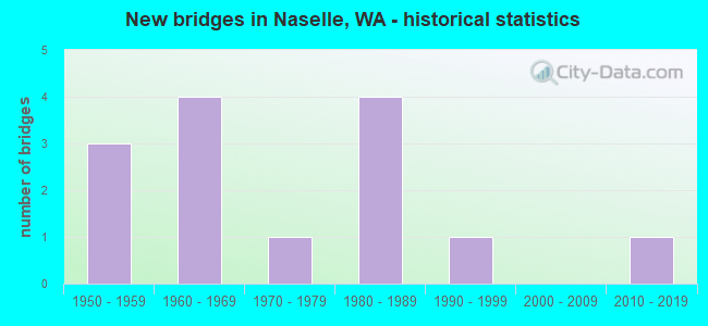
- New bridges - historical statistics
- 31950-1959
- 41960-1969
- 11970-1979
- 41980-1989
- 11990-1999
- 12010-2019

- Bridge Condition - Deck
- 7.7%Very good
- 61.5%Good
- 23.1%Satisfactory
- 7.7%Poor

- Bridge Condition - Superstructure
- 15.4%Very good
- 46.2%Good
- 30.8%Satisfactory
- 7.7%Poor

- Bridge Condition - Substructure
- 7.7%Very good
- 76.9%Good
- 7.7%Satisfactory
- 7.7%Poor

- Bridge Condition - Channel
- 28.6%Very good
- 35.7%Good
- 35.7%Satisfactory
Find on map >> Show street view
Structure Number: 4271A, Location: 11.4 N JCT US 101 (Lat: 46.366667, Lng: -123.810639), Route carried "on" structure: State highway 401, Year Built: 1953, Status: Open, Structure Length: 6.77m (22.21ft), Average Daily Traffic: 3,012 (year 2019), Truck Traffic: 10%, Average Future Daily Traffic: 3,662 (year 2039), Design Load: HS 15, Features Intersected: NASELLE R
Minimum Vertical Clearance: 30+ m (98+ ft), Kilometerpoint: 18.298, Lanes on structure: 2, Base Highway Network: Yes, Owner: State Highway Agency, Approaching Roadway Width: 12.8m (42.0ft), Material/Design: Concrete continuous, Design/Construction: Tee Beam, Number Of Spans In Main Unit: 4, Length of Maximum Span: 18.3m (60.0ft), Curb or Sidewalk Widths: Left: 0.8m (2.6ft), Right: 0.8m (2.6ft), Curb-To-Curb Width: 7.9m (25.9ft), Out-to-Out Width: 10.3m (33.8ft)
Condition: Deck: Good, Superstructure: Good, Substructure: Satisfactory, Channel: Satisfactory, Operating Rating: 22.0 metric tons, Method Used To Determine Operating Rating: Load and Resistance Factor Rating (LRFR) rating reported by rating factor(RF) method using HL-93 loadings, Inventory Rating: 16.8 metric tons, Method Used To Determine Inventory Rating: Load and Resistance Factor Rating (LRFR) rating reported by rating factor(RF) method using HL-93 loadings, Structural Evaluation: Meets minimum limits, Deck Geometry: High priority of corrective action, Waterway Adequacy: Equal to present desirable criteria, Approach Roadway Alignment: Equal to present desirable criteria, Length Of Structure Improvement: 6.77m (22.21ft), Designated Inspection Frequency: Every 24 months, Inspection Date: August 2021, Bridge Improvement Cost: $1,954,000, Roadway Improvement Cost: $391,000, Total Project Cost: $3,907,000 ( Estimate for 2014), Deck Structure Type: Concrete Cast-file-Place, Wearing Surface/Protective System: Wearing Surface: Monolithic Concrete
Find on map >> Show street view
Structure Number: 5871A, Location: 6.9 N JCT US 101 (Lat: 46.308528, Lng: -123.800917), Route carried "on" structure: State highway 401, Year Built: 1958, Status: Open, Structure Length: 3.14m (10.30ft), Average Daily Traffic: 2,940 (year 2019), Truck Traffic: 8%, Average Future Daily Traffic: 3,575 (year 2039), Design Load: HS 20, Features Intersected: BEAN CR
Minimum Vertical Clearance: 30+ m (98+ ft), Kilometerpoint: 11.056, Lanes on structure: 2, Base Highway Network: Yes, Owner: State Highway Agency, Approaching Roadway Width: 12.2m (40.0ft), Skew: 3 degrees, Material/Design: Concrete continuous, Design/Construction: Slab, Number Of Spans In Main Unit: 3, Length of Maximum Span: 11.6m (38.1ft), Curb-To-Curb Width: 8.8m (28.9ft), Out-to-Out Width: 9.8m (32.2ft)
Condition: Deck: Satisfactory, Superstructure: Satisfactory, Substructure: Good, Channel: Satisfactory, Operating Rating: 44.1 metric tons, Method Used To Determine Operating Rating: Load and Resistance Factor Rating (LRFR) rating reported by rating factor(RF) method using HL-93 loadings, Inventory Rating: 34.0 metric tons, Method Used To Determine Inventory Rating: Load and Resistance Factor Rating (LRFR) rating reported by rating factor(RF) method using HL-93 loadings, Structural Evaluation: Equal to present minimum criteria, Deck Geometry: Meets minimum limits, Waterway Adequacy: Equal to present desirable criteria, Approach Roadway Alignment: Equal to present desirable criteria, Length Of Structure Improvement: 3.14m (10.30ft), Designated Inspection Frequency: Every 24 months, Inspection Date: August 2021, Bridge Improvement Cost: $865,000, Roadway Improvement Cost: $173,000, Total Project Cost: $1,730,000 ( Estimate for 2014), Deck Structure Type: Concrete Cast-file-Place, Wearing Surface/Protective System: Wearing Surface: Monolithic Concrete
Find on map >> Show street view
Structure Number: 5871B, Location: 9.6 N JCT US 101 (Lat: 46.342278, Lng: -123.813750), Route carried "on" structure: State highway 401, Year Built: 1958, Status: Open, Structure Length: 2.35m (7.71ft), Average Daily Traffic: 2,588 (year 2019), Truck Traffic: 12%, Average Future Daily Traffic: 3,147 (year 2039), Design Load: HS 20, Features Intersected: DAVIS CREEK
Minimum Vertical Clearance: 30+ m (98+ ft), Kilometerpoint: 15.450, Lanes on structure: 2, Base Highway Network: Yes, Owner: State Highway Agency, Approaching Roadway Width: 11.6m (38.1ft), Skew: 1 degrees, Material/Design: Concrete continuous, Design/Construction: Slab, Number Of Spans In Main Unit: 3, Length of Maximum Span: 9.1m (29.9ft), Curb-To-Curb Width: 11.6m (38.1ft), Out-to-Out Width: 12.4m (40.7ft)
Condition: Deck: Satisfactory, Superstructure: Satisfactory, Substructure: Good, Channel: Good, Operating Rating: 35.0 metric tons, Method Used To Determine Operating Rating: Load and Resistance Factor Rating (LRFR) rating reported by rating factor(RF) method using HL-93 loadings, Inventory Rating: 26.9 metric tons, Method Used To Determine Inventory Rating: Load and Resistance Factor Rating (LRFR) rating reported by rating factor(RF) method using HL-93 loadings, Structural Evaluation: Equal to present minimum criteria, Deck Geometry: Somewhat better than minimum adequacy, Waterway Adequacy: Equal to present desirable criteria, Approach Roadway Alignment: Equal to present desirable criteria, Length Of Structure Improvement: 2.35m (7.71ft), Designated Inspection Frequency: Every 24 months, Inspection Date: August 2021, Bridge Improvement Cost: $616,000, Roadway Improvement Cost: $123,000, Total Project Cost: $1,232,000 ( Estimate for 2014), Deck Structure Type: Concrete Cast-file-Place, Wearing Surface/Protective System: Wearing Surface: Monolithic Concrete
Find on map >> Show street view
Structure Number: 7360A, Location: 11.6 N JCT US 101 (Lat: 46.369419, Lng: -123.808022), Route carried "on" structure: State highway 401, Year Built: 1964, Status: Open, Structure Length: 6.10m (20.01ft), Average Daily Traffic: 3,012 (year 2019), Truck Traffic: 10%, Average Future Daily Traffic: 3,662 (year 2039), Design Load: HS 20, Features Intersected: NASELLE RIVER OVERFLOW
Minimum Vertical Clearance: 30+ m (98+ ft), Kilometerpoint: 18.652, Lanes on structure: 2, Base Highway Network: Yes, Owner: State Highway Agency, Approaching Roadway Width: 11.6m (38.1ft), Material/Design: Concrete continuous, Design/Construction: Slab, Number Of Spans In Main Unit: 8, Length of Maximum Span: 8.5m (27.9ft), Curb or Sidewalk Widths: Left: 0.6m (2.0ft), Right: 0.6m (2.0ft), Curb-To-Curb Width: 8.5m (27.9ft), Out-to-Out Width: 11.0m (36.1ft)
Condition: Deck: Poor, Superstructure: Satisfactory, Substructure: Good, Channel: Very good, Operating Rating: 63.5 metric tons, Method Used To Determine Operating Rating: Load Factor (LF), Inventory Rating: 38.1 metric tons, Method Used To Determine Inventory Rating: Load Factor (LF), Structural Evaluation: Equal to present minimum criteria, Deck Geometry: Meets minimum limits, Waterway Adequacy: Equal to present desirable criteria, Approach Roadway Alignment: Equal to present desirable criteria, Length Of Structure Improvement: 6.10m (20.01ft), Designated Inspection Frequency: Every 24 months, Inspection Date: September 2020, Bridge Improvement Cost: $1,600,000, Roadway Improvement Cost: $320,000, Total Project Cost: $3,200,000 ( Estimate for 2014), Deck Structure Type: Concrete Cast-file-Place, Wearing Surface/Protective System: Wearing Surface: Monolithic Concrete
Find on map >> Show street view
Structure Number: 7360B, Location: 12.0 N JCT US 101 (Lat: 46.373611, Lng: -123.803611), Route carried "on" structure: State highway 401, Year Built: 1964, Status: Open, Structure Length: 3.08m (10.10ft), Average Daily Traffic: 3,012 (year 2019), Truck Traffic: 10%, Average Future Daily Traffic: 3,662 (year 2039), Design Load: HS 20, Features Intersected: NASELLE R OVERFLOW
Minimum Vertical Clearance: 30+ m (98+ ft), Kilometerpoint: 19.232, Lanes on structure: 2, Base Highway Network: Yes, Owner: State Highway Agency, Approaching Roadway Width: 11.6m (38.1ft), Material/Design: Concrete continuous, Design/Construction: Slab, Number Of Spans In Main Unit: 4, Length of Maximum Span: 8.5m (27.9ft), Curb or Sidewalk Widths: Left: 0.2m (0.7ft), Right: 0.2m (0.7ft), Curb-To-Curb Width: 11.6m (38.1ft), Out-to-Out Width: 12.7m (41.7ft)
Condition: Deck: Good, Superstructure: Good, Substructure: Good, Channel: Very good, Operating Rating: 69.8 metric tons, Method Used To Determine Operating Rating: Load Factor (LF), Inventory Rating: 41.7 metric tons, Method Used To Determine Inventory Rating: Load Factor (LF), Structural Evaluation: Better than present minimum criteria, Deck Geometry: Somewhat better than minimum adequacy, Waterway Adequacy: Equal to present desirable criteria, Approach Roadway Alignment: Equal to present desirable criteria, Length Of Structure Improvement: 3.08m (10.10ft), Designated Inspection Frequency: Every 48 months, Inspection Date: August 2018, Bridge Improvement Cost: $808,000, Roadway Improvement Cost: $162,000, Total Project Cost: $1,616,000 ( Estimate for 2014), Deck Structure Type: Concrete Cast-file-Place, Wearing Surface/Protective System: Wearing Surface: Monolithic Concrete
Find on map >> Show street view
Structure Number: 13040A, Location: 1.3 E JCT SR 401 (Lat: 46.368125, Lng: -123.780583), Route carried "on" structure: State highway 4, Year Built: 1987, Status: Open, Structure Length: 6.13m (20.11ft), Average Daily Traffic: 2,272 (year 2019), Truck Traffic: 11%, Average Future Daily Traffic: 2,762 (year 2039), Design Load: HS 20+Mod, Features Intersected: NASELLE RIVER
Minimum Vertical Clearance: 30+ m (98+ ft), Kilometerpoint: 9.753, Lanes on structure: 2, Base Highway Network: Yes, Owner: State Highway Agency, Approaching Roadway Width: 11.0m (36.1ft), Skew: 1 degrees, Material/Design: Prestressed concrete continuous, Design/Construction: Stringer/Multi-beam, Number Of Spans In Main Unit: 3, Length of Maximum Span: 23.2m (76.1ft), Curb-To-Curb Width: 11.0m (36.1ft), Out-to-Out Width: 11.9m (39.0ft)
Condition: Deck: Good, Superstructure: Good, Substructure: Good, Channel: Satisfactory, Operating Rating: 78.0 metric tons, Method Used To Determine Operating Rating: Load Factor (LF), Inventory Rating: 46.3 metric tons, Method Used To Determine Inventory Rating: Load Factor (LF), Structural Evaluation: Better than present minimum criteria, Deck Geometry: Somewhat better than minimum adequacy, Waterway Adequacy: Equal to present desirable criteria, Approach Roadway Alignment: Equal to present desirable criteria, Length Of Structure Improvement: 6.13m (20.11ft), Designated Inspection Frequency: Every 24 months, Inspection Date: August 2021, Bridge Improvement Cost: $1,528,000, Roadway Improvement Cost: $306,000, Total Project Cost: $3,055,000 ( Estimate for 2014), Deck Structure Type: Concrete Cast-file-Place, Wearing Surface/Protective System: Wearing Surface: Monolithic Concrete, Deck Protection: Epoxy Coated Reinforcing
Find on map >> Show street view
Structure Number: 13040B, Location: 2.4 E JCT SR 401 (Lat: 46.359319, Lng: -123.763028), Route carried "on" structure: State highway 4, Year Built: 1986, Status: Open, Structure Length: 3.35m (10.99ft), Average Daily Traffic: 2,272 (year 2019), Truck Traffic: 11%, Average Future Daily Traffic: 2,762 (year 2039), Design Load: HS 20+Mod, Features Intersected: SALMON CREEK
Minimum Vertical Clearance: 30+ m (98+ ft), Kilometerpoint: 11.442, Lanes on structure: 2, Base Highway Network: Yes, Owner: State Highway Agency, Approaching Roadway Width: 11.0m (36.1ft), Skew: 2 degrees, Material/Design: Prestressed concrete, Design/Construction: Stringer/Multi-beam, Number Of Spans In Main Unit: 1, Length of Maximum Span: 32.3m (106.0ft), Curb-To-Curb Width: 11.0m (36.1ft), Out-to-Out Width: 11.9m (39.0ft)
Condition: Deck: Good, Superstructure: Good, Substructure: Good, Channel: Satisfactory, Operating Rating: 64.4 metric tons, Method Used To Determine Operating Rating: Load Factor (LF), Inventory Rating: 38.1 metric tons, Method Used To Determine Inventory Rating: Load Factor (LF), Structural Evaluation: Better than present minimum criteria, Deck Geometry: Somewhat better than minimum adequacy, Waterway Adequacy: Equal to present desirable criteria, Approach Roadway Alignment: Equal to present desirable criteria, Length Of Structure Improvement: 3.35m (10.99ft), Designated Inspection Frequency: Every 24 months, Inspection Date: August 2021, Bridge Improvement Cost: $836,000, Roadway Improvement Cost: $167,000, Total Project Cost: $1,672,000 ( Estimate for 2014), Deck Structure Type: Concrete Cast-file-Place, Wearing Surface/Protective System: Wearing Surface: Monolithic Concrete, Deck Protection: Epoxy Coated Reinforcing
Find on map >> Show street view
Structure Number: 200503, Location: 3.1 E JCT US 101 (Lat: 46.390903, Lng: -123.827361), Route carried "on" structure: State highway 4, Year Built: 2015, Status: Open, Structure Length: 0.67m (2.20ft), Average Daily Traffic: 2,462 (year 2019), Truck Traffic: 10%, Average Future Daily Traffic: 2,993 (year 2039), Design Load: HS 20, Features Intersected: PETES CREEK
Minimum Vertical Clearance: 30+ m (98+ ft), Kilometerpoint: 5.005, Lanes on structure: 2, Base Highway Network: Yes, Owner: State Highway Agency, Approaching Roadway Width: 11.6m (38.1ft), Material/Design: Concrete, Design/Construction: Culvert, Number Of Spans In Main Unit: 1, Length of Maximum Span: 6.7m (22.0ft)
Condition: Channel: Very good, Culverts: Very good, Operating Rating: 44.1 metric tons, Method Used To Determine Operating Rating: Load and Resistance Factor Rating (LRFR) rating reported by rating factor(RF) method using HL-93 loadings, Inventory Rating: 34.0 metric tons, Method Used To Determine Inventory Rating: Load and Resistance Factor Rating (LRFR) rating reported by rating factor(RF) method using HL-93 loadings, Structural Evaluation: Equal to present desirable criteria, Waterway Adequacy: Equal to present desirable criteria, Approach Roadway Alignment: Equal to present desirable criteria, Length Of Structure Improvement: 0.98m (3.22ft), Designated Inspection Frequency: Every 24 months, Inspection Date: September 2021, Bridge Improvement Cost: $486,000, Roadway Improvement Cost: $97,000, Total Project Cost: $973,000 ( Estimate for 2014)
Find on map >> Show street view
Structure Number: 80718, Location: 1.0 S JCT 4 & 401 (Lat: 46.364611, Lng: -123.809778), Route carried "on" structure: County highway 91280, Year Built: 1965, Status: Posted for load, Structure Length: 3.66m (12.01ft), Average Daily Traffic: 352 (year 2018), Truck Traffic: 5%, Average Future Daily Traffic: 550 (year 2039), Design Load: HS 15, Features Intersected: SO FORK NASELLE RIVER, Facility Carried by Structure: SO VALLEY ROAD
Minimum Vertical Clearance: 30+ m (98+ ft), Kilometerpoint: 0.001, Lanes on structure: 2, Owner: County Highway Agency, Approaching Roadway Width: 8.5m (27.9ft), Skew: 1 degrees, Material/Design: Concrete continuous, Design/Construction: Slab, Number Of Spans In Main Unit: 3, Length of Maximum Span: 14.0m (45.9ft), Curb-To-Curb Width: 7.3m (24.0ft), Out-to-Out Width: 7.9m (25.9ft)
Condition: Deck: Good, Superstructure: Satisfactory, Substructure: Good, Channel: Good, Operating Rating: 26.3 metric tons, Method Used To Determine Operating Rating: Load and Resistance Factor (LRFR), Inventory Rating: 18.1 metric tons, Method Used To Determine Inventory Rating: Load and Resistance Factor (LRFR), Structural Evaluation: Somewhat better than minimum adequacy, Deck Geometry: Somewhat better than minimum adequacy, Waterway Adequacy: Equal to present desirable criteria, Approach Roadway Alignment: Equal to present minimum criteria, Bridge Posting: Required (Relationship of Operating Rating to Maximum Legal Load: 20.0 - 29.9% below), Length Of Structure Improvement: 3.66m (12.01ft), Designated Inspection Frequency: Every 24 months, Inspection Date: June 2020, Bridge Improvement Cost: $720,000, Roadway Improvement Cost: $144,000, Total Project Cost: $1,440,000 ( Estimate for 2014), Deck Structure Type: Concrete Cast-file-Place, Wearing Surface/Protective System: Wearing Surface: Monolithic Concrete
Find on map >> Show street view
Structure Number: 80834, Location: 1.3 SW JCT 4 & 401 (Lat: 46.367833, Lng: -123.821361), Route carried "on" structure: County highway 91190, Year Built: 1972, Status: Open, Structure Length: 1.52m (4.99ft), Average Daily Traffic: 145 (year 2018), Truck Traffic: 5%, Average Future Daily Traffic: 300 (year 2039), Design Load: HS 20, Features Intersected: DELL CREEK, Facility Carried by Structure: PARPALA ROAD
Minimum Vertical Clearance: 30+ m (98+ ft), Kilometerpoint: 0.001, Lanes on structure: 2, Owner: County Highway Agency, Approaching Roadway Width: 10.4m (34.1ft), Material/Design: Concrete continuous, Design/Construction: Slab, Number Of Spans In Main Unit: 3, Length of Maximum Span: 6.1m (20.0ft), Curb-To-Curb Width: 8.5m (27.9ft), Out-to-Out Width: 8.9m (29.2ft)
Condition: Deck: Good, Superstructure: Good, Substructure: Good, Channel: Good, Operating Rating: 33.6 metric tons, Method Used To Determine Operating Rating: Load and Resistance Factor (LRFR), Inventory Rating: 25.4 metric tons, Method Used To Determine Inventory Rating: Load and Resistance Factor (LRFR), Structural Evaluation: Equal to present minimum criteria, Deck Geometry: Equal to present minimum criteria, Waterway Adequacy: Equal to present desirable criteria, Approach Roadway Alignment: Equal to present minimum criteria, Length Of Structure Improvement: 1.52m (4.99ft), Designated Inspection Frequency: Every 24 months, Inspection Date: June 2020, Bridge Improvement Cost: $360,000, Roadway Improvement Cost: $72,000, Total Project Cost: $720,000 ( Estimate for 2014), Deck Structure Type: Other, Wearing Surface/Protective System: Wearing Surface: Bituminous
Find on map >> Show street view
Structure Number: 81115, Location: 1.7 SW JCT 4 & 401 (Lat: 46.364639, Lng: -123.781111), Route carried "on" structure: County highway 91280, Year Built: 1986, Status: Open, Structure Length: 4.82m (15.81ft), Average Daily Traffic: 213 (year 2018), Truck Traffic: 5%, Average Future Daily Traffic: 400 (year 2039), Design Load: HS 20, Features Intersected: SALMON CREEK, Facility Carried by Structure: SOUTH VALLEY ROAD
Minimum Vertical Clearance: 30+ m (98+ ft), Kilometerpoint: 0.001, Lanes on structure: 2, Owner: County Highway Agency, Approaching Roadway Width: 8.5m (27.9ft), Material/Design: Prestressed concrete continuous, Design/Construction: Tee Beam, Number Of Spans In Main Unit: 3, Length of Maximum Span: 25.9m (85.0ft), Curb-To-Curb Width: 8.5m (27.9ft), Out-to-Out Width: 9.4m (30.8ft)
Condition: Deck: Good, Superstructure: Good, Substructure: Good, Channel: Good, Operating Rating: 32.7 metric tons, Method Used To Determine Operating Rating: Load and Resistance Factor (LRFR), Inventory Rating: 22.7 metric tons, Method Used To Determine Inventory Rating: Load and Resistance Factor (LRFR), Structural Evaluation: Equal to present minimum criteria, Deck Geometry: Equal to present minimum criteria, Waterway Adequacy: Equal to present desirable criteria, Approach Roadway Alignment: Equal to present minimum criteria, Length Of Structure Improvement: 4.82m (15.81ft), Designated Inspection Frequency: Every 24 months, Inspection Date: June 2020, Bridge Improvement Cost: $948,000, Roadway Improvement Cost: $190,000, Total Project Cost: $1,896,000 ( Estimate for 2014), Deck Structure Type: Concrete Cast-file-Place, Wearing Surface/Protective System: Wearing Surface: Monolithic Concrete
Find on map >> Show street view
Structure Number: 81446, Location: 2.9 E JCT 4 & 401 (Lat: 46.373389, Lng: -123.747583), Route carried "on" structure: County highway 91280, Year Built: 1984, Status: Open, Structure Length: 2.19m (7.19ft), Average Daily Traffic: 140 (year 2018), Truck Traffic: 5%, Average Future Daily Traffic: 300 (year 2039), Design Load: HS 20, Features Intersected: DOG CREEK, Facility Carried by Structure: NORTH VALLEY ROAD
Minimum Vertical Clearance: 30+ m (98+ ft), Kilometerpoint: 0.001, Lanes on structure: 2, Owner: County Highway Agency, Approaching Roadway Width: 7.9m (25.9ft), Material/Design: Prestressed concrete, Design/Construction: Stringer/Multi-beam, Number Of Spans In Main Unit: 1, Length of Maximum Span: 20.7m (67.9ft), Curb-To-Curb Width: 9.1m (29.9ft), Out-to-Out Width: 9.8m (32.2ft)
Condition: Deck: Very good, Superstructure: Very good, Substructure: Good, Channel: Very good, Operating Rating: 54.4 metric tons, Method Used To Determine Operating Rating: Load and Resistance Factor (LRFR), Inventory Rating: 39.0 metric tons, Method Used To Determine Inventory Rating: Load and Resistance Factor (LRFR), Structural Evaluation: Better than present minimum criteria, Deck Geometry: Equal to present minimum criteria, Waterway Adequacy: Equal to present desirable criteria, Approach Roadway Alignment: Equal to present minimum criteria, Length Of Structure Improvement: 2.19m (7.19ft), Designated Inspection Frequency: Every 24 months, Inspection Date: June 2020, Bridge Improvement Cost: $403,000, Roadway Improvement Cost: $81,000, Total Project Cost: $806,000 ( Estimate for 2014), Deck Structure Type: Concrete Cast-file-Place, Wearing Surface/Protective System: Wearing Surface: Monolithic Concrete
Find on map >> Show street view
Structure Number: 8269, Location: 0.37 N JCT SR 401 (Lat: 46.342583, Lng: -123.812583), Route carried "on" structure: County highway 17690, Year Built: 1963, Status: Posted for load, Structure Length: 1.49m (4.89ft), Average Daily Traffic: 185 (year 2020), Average Future Daily Traffic: 400 (year 2039), Design Load: H 15, Features Intersected: DAVIS CREEK, Facility Carried by Structure: KNAPPTON ROAD
Minimum Vertical Clearance: 30+ m (98+ ft), Kilometerpoint: 0.001, Lanes on structure: 2, Owner: County Highway Agency, Approaching Roadway Width: 7.3m (24.0ft), Material/Design: Wood or Timber, Design/Construction: Stringer/Multi-beam, Number Of Spans In Main Unit: 3, Length of Maximum Span: 7.3m (24.0ft), Curb-To-Curb Width: 5.8m (19.0ft), Out-to-Out Width: 6.1m (20.0ft)
Condition: Deck: Satisfactory, Superstructure: Poor, Substructure: Poor, Channel: Good, Operating Rating: 16.3 metric tons, Method Used To Determine Operating Rating: Load and Resistance Factor (LRFR), Inventory Rating: 11.8 metric tons, Method Used To Determine Inventory Rating: Load and Resistance Factor (LRFR), Structural Evaluation: Meets minimum limits, Deck Geometry: High priority of corrective action, Waterway Adequacy: Better than present minimum criteria, Approach Roadway Alignment: Equal to present desirable criteria, Bridge Posting: Required (Relationship of Operating Rating to Maximum Legal Load: 0.1 - 9.9% below), Length Of Structure Improvement: 1.80m (5.91ft), Designated Inspection Frequency: Every 12 months, Inspection Date: June 2021, Bridge Improvement Cost: $897,000, Roadway Improvement Cost: $179,000, Total Project Cost: $1,794,000 ( Estimate for 2014), Deck Structure Type: Wood or Timber, Wearing Surface/Protective System: Wearing Surface: Bituminous
Find on map >> Show street view
Structure Number: 86215, Location: 0.74 E JCT 401 (Lat: 46.346861, Lng: -123.811250), Route carried "on" structure: County highway 17520, Year Built: 1996, Status: Open, Structure Length: 3.81m (12.50ft), Average Daily Traffic: 48 (year 2021), Average Future Daily Traffic: 90 (year 2039), Design Load: HS 20, Features Intersected: SO FORK NASELLE RIVER, Facility Carried by Structure: NYBERG ROAD
Minimum Vertical Clearance: 30+ m (98+ ft), Kilometerpoint: 0.001, Lanes on structure: 2, Owner: County Highway Agency, Approaching Roadway Width: 8.5m (27.9ft), Skew: 7 degrees, Material/Design: Prestressed concrete continuous, Design/Construction: Stringer/Multi-beam, Number Of Spans In Main Unit: 2, Length of Maximum Span: 24.4m (80.1ft), Curb-To-Curb Width: 8.5m (27.9ft), Out-to-Out Width: 9.1m (29.9ft)
Condition: Deck: Good, Superstructure: Very good, Substructure: Very good, Channel: Satisfactory, Operating Rating: 46.3 metric tons, Method Used To Determine Operating Rating: Load and Resistance Factor (LRFR), Inventory Rating: 31.7 metric tons, Method Used To Determine Inventory Rating: Load and Resistance Factor (LRFR), Structural Evaluation: Better than present minimum criteria, Deck Geometry: Better than present minimum criteria, Waterway Adequacy: Better than present minimum criteria, Approach Roadway Alignment: Equal to present desirable criteria, Length Of Structure Improvement: 3.81m (12.50ft), Designated Inspection Frequency: Every 24 months, Inspection Date: June 2021, Bridge Improvement Cost: $750,000, Roadway Improvement Cost: $150,000, Total Project Cost: $1,500,000 ( Estimate for 2014), Deck Structure Type: Concrete Cast-file-Place, Wearing Surface/Protective System: Wearing Surface: Monolithic Concrete, Deck Protection: Epoxy Coated Reinforcing