Bridge Statistics for Nashville, Georgia (GA)
Condition, Traffic, Stress, Structural Evaluation, Project Costs
- National Bridge Inventory (NBI) Statistics
- 21Number of bridges
- 223ft / 68.4mTotal length
- $13,145,000Total costs
- 38,840Total average daily traffic
- 2,562Total average daily truck traffic
- 58,260Total future (year 2031) average daily traffic
- National Bridge Inventory (NBI) Registered Bridges for Nashville
- No street view available for this location
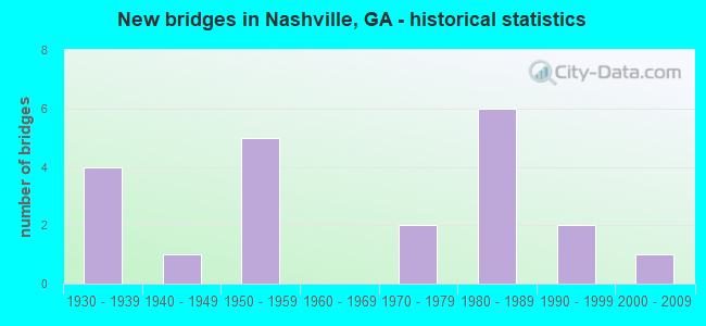
- New bridges - historical statistics
- 41930-1939
- 11940-1949
- 51950-1959
- 21970-1979
- 61980-1989
- 21990-1999
- 12000-2009

- Reconstructed bridges - Historical Statistics
- 21980-1989
- 11990-1999


- Bridge Condition - Deck
- 75.0%Good
- 25.0%Satisfactory

- Bridge Condition - Substructure
- 87.5%Good
- 12.5%Satisfactory

- Bridge Condition - Channel
- 19.0%Very good
- 52.4%Good
- 23.8%Satisfactory
- 4.8%Fair
Find on map >> Show street view
Structure Number: 190003, Location: APP 6 MI N W OF RAY CITY (Lat: 31.139158, Lng: -83.216628), Route carried "on" structure: US 129, Year Built: 1932, Status: Open, Structure Length: 0.98m (3.22ft), Average Daily Traffic: 3,370 (year 2011), Truck Traffic: 9%, Average Future Daily Traffic: 5,055 (year 2031), Design Load: H 15, Features Intersected: CAT CREEK
Minimum Vertical Clearance: 30+ m (98+ ft), Kilometerpoint: 11.265, Lanes on structure: 2, Base Highway Network: Yes, Owner: State Highway Agency, Approaching Roadway Width: 8.5m (27.9ft), Material/Design: Concrete, Design/Construction: Culvert, Number Of Spans In Main Unit: 3, Length of Maximum Span: 3.0m (9.8ft)
Condition: Channel: Satisfactory, Culverts: Good, Operating Rating: 40.8 metric tons, Method Used To Determine Operating Rating: Field evaluation and documented engineering judgment, Inventory Rating: 24.4 metric tons, Method Used To Determine Inventory Rating: Field evaluation and documented engineering judgment, Structural Evaluation: Equal to present minimum criteria, Waterway Adequacy: Equal to present minimum criteria, Approach Roadway Alignment: Better than present minimum criteria, Designated Inspection Frequency: Every 24 months, Inspection Date: June 2020, Bridge Improvement Cost: $125,000, Roadway Improvement Cost: $13,000, Total Project Cost: $188,000
Find on map >> Show street view
Structure Number: 190004, Location: APP 4 MI N OF NASHVILLE (Lat: 31.266119, Lng: -83.239739), Route carried "on" structure: US 129, Year Built: 1937, Status: Open, Structure Length: 0.82m (2.69ft), Average Daily Traffic: 2,120 (year 2011), Truck Traffic: 7%, Average Future Daily Traffic: 3,180 (year 2031), Design Load: H 15, Features Intersected: FLAT CREEK
Minimum Vertical Clearance: 30+ m (98+ ft), Kilometerpoint: 25.750, Lanes on structure: 2, Base Highway Network: Yes, Owner: State Highway Agency, Approaching Roadway Width: 8.5m (27.9ft), Material/Design: Concrete, Design/Construction: Culvert, Number Of Spans In Main Unit: 3, Length of Maximum Span: 2.4m (7.9ft)
Condition: Channel: Good, Culverts: Good, Operating Rating: 40.8 metric tons, Method Used To Determine Operating Rating: Field evaluation and documented engineering judgment, Inventory Rating: 24.4 metric tons, Method Used To Determine Inventory Rating: Field evaluation and documented engineering judgment, Structural Evaluation: Equal to present minimum criteria, Waterway Adequacy: Equal to present minimum criteria, Approach Roadway Alignment: Better than present minimum criteria, Designated Inspection Frequency: Every 24 months, Underwater Inspection Frequency: Every 60 months, Inspection Date: June 2020, Underwater Inspection Date: April 2021, Bridge Improvement Cost: $105,000, Roadway Improvement Cost: $11,000, Total Project Cost: $158,000
Find on map >> Show street view
Structure Number: 190019, Location: APP 4 MI W OF NASHVILLE (Lat: 31.180408, Lng: -83.318617), Route carried "on" structure: State highway 76, Year Built: 1933, Status: Open, Structure Length: 0.79m (2.59ft), Average Daily Traffic: 3,040 (year 2011), Truck Traffic: 10%, Average Future Daily Traffic: 4,560 (year 2031), Design Load: H 15, Features Intersected: DISTRICT BRANCH
Minimum Vertical Clearance: 30+ m (98+ ft), Kilometerpoint: 0.000, Lanes on structure: 2, Base Highway Network: Yes, Owner: State Highway Agency, Approaching Roadway Width: 8.8m (28.9ft), Material/Design: Concrete, Design/Construction: Culvert, Number Of Spans In Main Unit: 3, Length of Maximum Span: 2.4m (7.9ft)
Condition: Channel: Good, Culverts: Good, Operating Rating: 48.0 metric tons, Method Used To Determine Operating Rating: Load Factor (LF), Inventory Rating: 29.0 metric tons, Method Used To Determine Inventory Rating: Load Factor (LF), Structural Evaluation: Better than present minimum criteria, Waterway Adequacy: Equal to present minimum criteria, Approach Roadway Alignment: Better than present minimum criteria, Designated Inspection Frequency: Every 24 months, Inspection Date: June 2020, Bridge Improvement Cost: $102,000, Roadway Improvement Cost: $10,000, Total Project Cost: $152,000
Find on map >> Show street view
Structure Number: 19002, Location: 2.5 MI SW OF NASHVILLE (Lat: 31.197872, Lng: -83.276781), Route carried "on" structure: State highway 76, Year Built: 1986, Status: Open, Structure Length: 3.66m (12.01ft), Average Daily Traffic: 3,040 (year 2011), Truck Traffic: 10%, Average Future Daily Traffic: 4,560 (year 2031), Design Load: HS 20+Mod, Features Intersected: WITHLACOOCHE RIVER O/F
Minimum Vertical Clearance: 30+ m (98+ ft), Kilometerpoint: 4.828, Lanes on structure: 2, Base Highway Network: Yes, Owner: State Highway Agency, Approaching Roadway Width: 8.8m (28.9ft), Skew: 1 degrees, Material/Design: Concrete, Design/Construction: Tee Beam, Number Of Spans In Main Unit: 3, Length of Maximum Span: 12.2m (40.0ft), Curb-To-Curb Width: 12.2m (40.0ft), Out-to-Out Width: 13.2m (43.3ft)
Condition: Deck: Good, Superstructure: Good, Substructure: Good, Channel: Good, Operating Rating: 34.4 metric tons, Method Used To Determine Operating Rating: Load Factor (LF), Inventory Rating: 20.8 metric tons, Method Used To Determine Inventory Rating: Load Factor (LF), Structural Evaluation: Somewhat better than minimum adequacy, Deck Geometry: Equal to present minimum criteria, Waterway Adequacy: Equal to present desirable criteria, Approach Roadway Alignment: Equal to present desirable criteria, Designated Inspection Frequency: Every 24 months, Inspection Date: June 2020, Bridge Improvement Cost: $469,000, Roadway Improvement Cost: $47,000, Total Project Cost: $703,000, Deck Structure Type: Concrete Cast-file-Place
Find on map >> Show street view
Structure Number: 190021, Location: 2 MI SW OF NASHVILLE (Lat: 31.197328, Lng: -83.272031), Route carried "on" structure: State highway 76, Year Built: 1986, Status: Open, Structure Length: 8.53m (27.99ft), Average Daily Traffic: 2,990 (year 2011), Truck Traffic: 1%, Average Future Daily Traffic: 4,485 (year 2031), Design Load: HS 20+Mod, Features Intersected: WITHLACOOCHE RIVER
Minimum Vertical Clearance: 30+ m (98+ ft), Kilometerpoint: 4.828, Lanes on structure: 2, Base Highway Network: Yes, Owner: State Highway Agency, Approaching Roadway Width: 8.8m (28.9ft), Skew: 1 degrees, Material/Design: Concrete, Design/Construction: Tee Beam, Number Of Spans In Main Unit: 7, Length of Maximum Span: 12.2m (40.0ft), Curb-To-Curb Width: 12.2m (40.0ft), Out-to-Out Width: 13.2m (43.3ft)
Condition: Deck: Good, Superstructure: Good, Substructure: Good, Channel: Very good, Operating Rating: 34.4 metric tons, Method Used To Determine Operating Rating: Load Factor (LF), Inventory Rating: 20.8 metric tons, Method Used To Determine Inventory Rating: Load Factor (LF), Structural Evaluation: Somewhat better than minimum adequacy, Deck Geometry: Equal to present minimum criteria, Waterway Adequacy: Equal to present desirable criteria, Approach Roadway Alignment: Equal to present desirable criteria, Designated Inspection Frequency: Every 24 months, Underwater Inspection Frequency: Every 60 months, Inspection Date: June 2020, Underwater Inspection Date: April 2021, Bridge Improvement Cost: $1,094,000, Roadway Improvement Cost: $109,000, Total Project Cost: $1,641,000, Deck Structure Type: Concrete Cast-file-Place
Find on map >> Show street view
Structure Number: 190022, Location: 3.5 MI E OF NASHVILLE (Lat: 31.210053, Lng: -83.203656), Route carried "on" structure: State highway 76, Year Built: 1938, Status: Open, Structure Length: 1.28m (4.20ft), Average Daily Traffic: 1,330 (year 2011), Truck Traffic: 1%, Average Future Daily Traffic: 1,995 (year 2031), Design Load: H 15, Features Intersected: TEN MILE CREEK TRIB
Minimum Vertical Clearance: 30+ m (98+ ft), Kilometerpoint: 12.875, Lanes on structure: 2, Base Highway Network: Yes, Owner: State Highway Agency, Approaching Roadway Width: 7.0m (23.0ft), Skew: 4 degrees, Material/Design: Concrete, Design/Construction: Culvert, Number Of Spans In Main Unit: 3, Length of Maximum Span: 4.0m (13.1ft)
Condition: Channel: Satisfactory, Culverts: Good, Operating Rating: 49.8 metric tons, Method Used To Determine Operating Rating: Load Factor (LF), Inventory Rating: 29.9 metric tons, Method Used To Determine Inventory Rating: Load Factor (LF), Structural Evaluation: Better than present minimum criteria, Waterway Adequacy: Equal to present minimum criteria, Approach Roadway Alignment: Better than present minimum criteria, Designated Inspection Frequency: Every 24 months, Inspection Date: July 2020, Bridge Improvement Cost: $164,000, Roadway Improvement Cost: $16,000, Total Project Cost: $246,000
Find on map >> Show street view
Structure Number: 190023, Location: APP 4 MI E OF NASHVILLE (Lat: 31.214103, Lng: -83.193011), Route carried "on" structure: State highway 76, Year Built: 1940, Status: Open, Structure Length: 1.34m (4.40ft), Average Daily Traffic: 1,330 (year 2011), Truck Traffic: 1%, Average Future Daily Traffic: 1,995 (year 2031), Design Load: H 15, Features Intersected: TEN MILE CREEK
Minimum Vertical Clearance: 30+ m (98+ ft), Kilometerpoint: 14.484, Lanes on structure: 2, Base Highway Network: Yes, Owner: State Highway Agency, Approaching Roadway Width: 7.0m (23.0ft), Material/Design: Concrete, Design/Construction: Culvert, Number Of Spans In Main Unit: 4, Length of Maximum Span: 3.0m (9.8ft)
Condition: Channel: Satisfactory, Culverts: Good, Operating Rating: 38.1 metric tons, Method Used To Determine Operating Rating: Load Factor (LF), Inventory Rating: 22.6 metric tons, Method Used To Determine Inventory Rating: Load Factor (LF), Structural Evaluation: Equal to present minimum criteria, Waterway Adequacy: Equal to present minimum criteria, Approach Roadway Alignment: Better than present minimum criteria, Designated Inspection Frequency: Every 24 months, Inspection Date: July 2020, Bridge Improvement Cost: $172,000, Roadway Improvement Cost: $17,000, Total Project Cost: $258,000
Find on map >> Show street view
Structure Number: 190026, Location: WEST NASHVILLE (Lat: 31.209608, Lng: -83.254089), Route carried "on" structure: State highway 125, Year Built: 1952, Status: Open, Structure Length: 0.82m (2.69ft), Average Daily Traffic: 4,810 (year 2011), Truck Traffic: 12%, Average Future Daily Traffic: 7,215 (year 2031), Design Load: H 15, Features Intersected: REEDY CREEK
Minimum Vertical Clearance: 30+ m (98+ ft), Kilometerpoint: 19.312, Lanes on structure: 2, Base Highway Network: Yes, Owner: State Highway Agency, Approaching Roadway Width: 7.3m (24.0ft), Material/Design: Concrete, Design/Construction: Culvert, Number Of Spans In Main Unit: 3, Length of Maximum Span: 2.4m (7.9ft), Curb-To-Curb Width: 9.1m (29.9ft), Out-to-Out Width: 9.9m (32.5ft)
Condition: Channel: Good, Culverts: Good, Operating Rating: 38.1 metric tons, Method Used To Determine Operating Rating: Load Factor (LF), Inventory Rating: 22.6 metric tons, Method Used To Determine Inventory Rating: Load Factor (LF), Structural Evaluation: Equal to present minimum criteria, Deck Geometry: Meets minimum limits, Waterway Adequacy: Equal to present minimum criteria, Approach Roadway Alignment: Somewhat better than minimum adequacy, Length Of Structure Improvement: 41.06m (134.71ft), Designated Inspection Frequency: Every 24 months, Inspection Date: June 2020, Bridge Improvement Cost: $105,000, Roadway Improvement Cost: $11,000, Total Project Cost: $158,000
Find on map >> Show street view
Structure Number: 190027, Location: 2.5 MI N OF NASHVILLE (Lat: 31.215119, Lng: -83.269369), Route carried "on" structure: State highway 125, Year Built: 1952, Year Reconstructed: 1994, Status: Open, Structure Length: 5.76m (18.90ft), Average Daily Traffic: 2,210 (year 2011), Truck Traffic: 12%, Average Future Daily Traffic: 3,315 (year 2031), Design Load: H 15, Features Intersected: SIMON BRANCH
Minimum Vertical Clearance: 30+ m (98+ ft), Kilometerpoint: 20.921, Lanes on structure: 2, Base Highway Network: Yes, Owner: State Highway Agency, Approaching Roadway Width: 8.2m (26.9ft), Material/Design: Steel continuous, Design/Construction: Stringer/Multi-beam, Number Of Spans In Main Unit: 7, Length of Maximum Span: 8.2m (26.9ft), Curb-To-Curb Width: 12.2m (40.0ft), Out-to-Out Width: 13.1m (43.0ft)
Condition: Deck: Satisfactory, Superstructure: Good, Substructure: Good, Channel: Good, Operating Rating: 36.2 metric tons, Method Used To Determine Operating Rating: Load Factor (LF), Inventory Rating: 18.1 metric tons, Method Used To Determine Inventory Rating: Load Factor (LF), Structural Evaluation: Somewhat better than minimum adequacy, Deck Geometry: Equal to present minimum criteria, Waterway Adequacy: Equal to present minimum criteria, Approach Roadway Alignment: Better than present minimum criteria, Length Of Structure Improvement: 12.19m (39.99ft), Designated Inspection Frequency: Every 24 months, Inspection Date: June 2020, Bridge Improvement Cost: $738,000, Roadway Improvement Cost: $74,000, Total Project Cost: $1,108,000, Deck Structure Type: Concrete Cast-file-Place
Find on map >> Show street view
Structure Number: 190028, Location: APP 3 MI W OF NASHVILLE (Lat: 31.216178, Lng: -83.273947), Route carried "on" structure: State highway 125, Year Built: 1952, Year Reconstructed: 1994, Status: Open, Structure Length: 12.74m (41.80ft), Average Daily Traffic: 2,010 (year 2011), Truck Traffic: 8%, Average Future Daily Traffic: 3,015 (year 2031), Design Load: H 15, Features Intersected: WITHLACOOCHEE RIVER
Minimum Vertical Clearance: 30+ m (98+ ft), Kilometerpoint: 20.921, Lanes on structure: 2, Base Highway Network: Yes, Owner: State Highway Agency, Approaching Roadway Width: 8.5m (27.9ft), Skew: 2 degrees, Material/Design: Steel, Design/Construction: Stringer/Multi-beam, Number Of Spans In Main Unit: 15, Length of Maximum Span: 12.2m (40.0ft), Curb-To-Curb Width: 12.2m (40.0ft), Out-to-Out Width: 13.1m (43.0ft)
Condition: Deck: Satisfactory, Superstructure: Good, Substructure: Good, Channel: Good, Operating Rating: 38.1 metric tons, Method Used To Determine Operating Rating: Load Factor (LF), Inventory Rating: 22.6 metric tons, Method Used To Determine Inventory Rating: Load Factor (LF), Structural Evaluation: Equal to present minimum criteria, Deck Geometry: Equal to present minimum criteria, Waterway Adequacy: Equal to present minimum criteria, Approach Roadway Alignment: Better than present minimum criteria, Length Of Structure Improvement: 19.17m (62.89ft), Designated Inspection Frequency: Every 24 months, Underwater Inspection Frequency: Every 60 months, Inspection Date: June 2020, Underwater Inspection Date: April 2021, Bridge Improvement Cost: $1,633,000, Roadway Improvement Cost: $163,000, Total Project Cost: $2,450,000, Deck Structure Type: Concrete Cast-file-Place
Find on map >> Show street view
Structure Number: 19004, Location: WEST NASHVILLE (Lat: 31.209539, Lng: -83.254378), Route carried "on" structure: County highway 557, Year Built: 1958, Status: Open, Structure Length: 1.01m (3.31ft), Average Daily Traffic: 3,230 (year 2011), Truck Traffic: 1%, Average Future Daily Traffic: 4,845 (year 2031), Design Load: H 15, Features Intersected: REEDY CREEK, Facility Carried by Structure: DOGWOOD DRIVE
Minimum Vertical Clearance: 30+ m (98+ ft), Kilometerpoint: 20.921, Lanes on structure: 2, Base Highway Network: Yes, Owner: County Highway Agency, Approaching Roadway Width: 14.0m (45.9ft), Skew: 3 degrees, Material/Design: Concrete, Design/Construction: Culvert, Number Of Spans In Main Unit: 3, Length of Maximum Span: 3.0m (9.8ft), Curb or Sidewalk Widths: Left: 1.5m (4.9ft), Right: 1.5m (4.9ft)
Condition: Channel: Good, Culverts: Good, Operating Rating: 36.2 metric tons, Method Used To Determine Operating Rating: Load Factor (LF), Inventory Rating: 21.7 metric tons, Method Used To Determine Inventory Rating: Load Factor (LF), Structural Evaluation: Somewhat better than minimum adequacy, Waterway Adequacy: Equal to present minimum criteria, Approach Roadway Alignment: Better than present minimum criteria, Designated Inspection Frequency: Every 24 months, Inspection Date: June 2020, Bridge Improvement Cost: $129,000, Roadway Improvement Cost: $13,000, Total Project Cost: $193,000
Find on map >> Show street view
Structure Number: 190041, Location: 3 MI N OF NASHVILLE (Lat: 31.262969, Lng: -83.263889), Route carried "on" structure: County highway 1210, Year Built: 1990, Status: Open, Structure Length: 1.22m (4.00ft), Average Daily Traffic: 810 (year 2011), Truck Traffic: 1%, Average Future Daily Traffic: 1,215 (year 2031), Design Load: HS 20+Mod, Features Intersected: FLAT CREEK, Facility Carried by Structure: NASHVILLE ENIGMA
Minimum Vertical Clearance: 30+ m (98+ ft), Kilometerpoint: 6.437, Lanes on structure: 2, Base Highway Network: Yes, Owner: County Highway Agency, Approaching Roadway Width: 8.2m (26.9ft), Material/Design: Concrete, Design/Construction: Culvert, Number Of Spans In Main Unit: 4, Length of Maximum Span: 2.7m (8.9ft)
Condition: Channel: Good, Culverts: Good, Operating Rating: 41.7 metric tons, Method Used To Determine Operating Rating: Load Factor (LF), Inventory Rating: 24.4 metric tons, Method Used To Determine Inventory Rating: Load Factor (LF), Structural Evaluation: Equal to present minimum criteria, Waterway Adequacy: Equal to present minimum criteria, Approach Roadway Alignment: Equal to present desirable criteria, Designated Inspection Frequency: Every 24 months, Inspection Date: June 2020, Bridge Improvement Cost: $156,000, Roadway Improvement Cost: $16,000, Total Project Cost: $234,000
Find on map >> Show street view
Structure Number: 195011, Location: 3.4 MI E OF NASHVILLE (Lat: 31.206908, Lng: -83.194747), Route carried "on" structure: County highway 27, Year Built: 1970, Year Reconstructed: 2002, Status: Open, Structure Length: 3.72m (12.20ft), Average Daily Traffic: 360 (year 2011), Truck Traffic: 8%, Average Future Daily Traffic: 540 (year 2031), Design Load: H 15, Features Intersected: TEN MILE CREEK
Minimum Vertical Clearance: 30+ m (98+ ft), Kilometerpoint: 3.219, Lanes on structure: 2, Base Highway Network: Yes, Owner: County Highway Agency, Approaching Roadway Width: 5.8m (19.0ft), Material/Design: Prestressed concrete, Design/Construction: Channel Beam, Number Of Spans In Main Unit: 6, Length of Maximum Span: 6.1m (20.0ft), Curb-To-Curb Width: 7.1m (23.3ft), Out-to-Out Width: 7.7m (25.3ft)
Condition: Deck: Good, Superstructure: Good, Substructure: Good, Channel: Satisfactory, Operating Rating: 44.4 metric tons, Method Used To Determine Operating Rating: Load Factor (LF), Inventory Rating: 26.3 metric tons, Method Used To Determine Inventory Rating: Load Factor (LF), Structural Evaluation: Equal to present minimum criteria, Deck Geometry: Meets minimum limits, Waterway Adequacy: Better than present minimum criteria, Approach Roadway Alignment: Better than present minimum criteria, Length Of Structure Improvement: 10.15m (33.30ft), Designated Inspection Frequency: Every 24 months, Inspection Date: July 2020, Bridge Improvement Cost: $477,000, Roadway Improvement Cost: $48,000, Total Project Cost: $715,000, Deck Structure Type: Concrete Precast Panels
Find on map >> Show street view
Structure Number: 195017, Location: APP 4 MI NW OF RAY CITY (Lat: 31.133608, Lng: -83.222889), Route carried "on" structure: County highway 55, Year Built: 1980, Status: Posted for load, Structure Length: 2.44m (8.01ft), Average Daily Traffic: 260 (year 2011), Truck Traffic: 9%, Average Future Daily Traffic: 390 (year 2031), Design Load: HS 15, Features Intersected: CAT CREEK, Facility Carried by Structure: ALLENVILLE ROAD
Minimum Vertical Clearance: 30+ m (98+ ft), Kilometerpoint: 1.609, Lanes on structure: 2, Base Highway Network: Yes, Owner: County Highway Agency, Approaching Roadway Width: 6.1m (20.0ft), Material/Design: Concrete, Design/Construction: Slab, Number Of Spans In Main Unit: 4, Length of Maximum Span: 6.1m (20.0ft), Curb-To-Curb Width: 9.8m (32.2ft), Out-to-Out Width: 10.6m (34.8ft)
Condition: Deck: Good, Superstructure: Good, Substructure: Satisfactory, Channel: Fair, Operating Rating: 33.5 metric tons, Method Used To Determine Operating Rating: Load Factor (LF), Inventory Rating: 22.6 metric tons, Method Used To Determine Inventory Rating: Load Factor (LF), Structural Evaluation: Equal to present minimum criteria, Deck Geometry: Better than present minimum criteria, Waterway Adequacy: Better than present minimum criteria, Approach Roadway Alignment: Better than present minimum criteria, Bridge Posting: Required (Relationship of Operating Rating to Maximum Legal Load: 10.0 - 19.9% below), Designated Inspection Frequency: Every 24 months, Inspection Date: June 2020, Bridge Improvement Cost: $313,000, Roadway Improvement Cost: $31,000, Total Project Cost: $469,000, Deck Structure Type: Concrete Precast Panels, Wearing Surface/Protective System: Wearing Surface: Bituminous
Find on map >> Show street view
Structure Number: 195037, Location: 3.6 MI NE OF NASHVILLE (Lat: 31.221019, Lng: -83.189958), Route carried "on" structure: County highway 178, Year Built: 1990, Status: Open, Structure Length: 1.34m (4.40ft), Average Daily Traffic: 60 (year 2011), Truck Traffic: 1%, Average Future Daily Traffic: 90 (year 2031), Design Load: HS 20+Mod, Features Intersected: TEN MILE CREEK, Facility Carried by Structure: AVERA MILL ROAD
Minimum Vertical Clearance: 30+ m (98+ ft), Kilometerpoint: 4.828, Lanes on structure: 2, Base Highway Network: Yes, Owner: County Highway Agency, Approaching Roadway Width: 4.3m (14.1ft), Material/Design: Concrete, Design/Construction: Culvert, Number Of Spans In Main Unit: 5, Length of Maximum Span: 2.4m (7.9ft)
Condition: Channel: Good, Culverts: Good, Operating Rating: 55.3 metric tons, Method Used To Determine Operating Rating: Field evaluation and documented engineering judgment, Inventory Rating: 32.6 metric tons, Method Used To Determine Inventory Rating: Field evaluation and documented engineering judgment, Structural Evaluation: Better than present minimum criteria, Waterway Adequacy: Better than present minimum criteria, Approach Roadway Alignment: Better than present minimum criteria, Designated Inspection Frequency: Every 24 months, Inspection Date: July 2020, Bridge Improvement Cost: $172,000, Roadway Improvement Cost: $17,000, Total Project Cost: $258,000
Find on map >> Show street view
Structure Number: 195056, Location: 2 MI SW OF NASHVILLE (Lat: 31.185828, Lng: -83.268169), Route carried "on" structure: County highway 360, Year Built: 1955, Status: Open, Structure Length: 0.79m (2.59ft), Average Daily Traffic: 710 (year 2011), Truck Traffic: 1%, Average Future Daily Traffic: 1,065 (year 2031), Design Load: H 15, Features Intersected: WITHLACOOCHEE RIVER TRIB, Facility Carried by Structure: CECIL ROAD
Minimum Vertical Clearance: 30+ m (98+ ft), Kilometerpoint: 16.093, Lanes on structure: 2, Base Highway Network: Yes, Owner: County Highway Agency, Approaching Roadway Width: 5.8m (19.0ft), Material/Design: Concrete, Design/Construction: Culvert, Number Of Spans In Main Unit: 3, Length of Maximum Span: 2.4m (7.9ft)
Condition: Channel: Satisfactory, Culverts: Good, Operating Rating: 48.9 metric tons, Method Used To Determine Operating Rating: Load Factor (LF), Inventory Rating: 29.0 metric tons, Method Used To Determine Inventory Rating: Load Factor (LF), Structural Evaluation: Better than present minimum criteria, Waterway Adequacy: Equal to present minimum criteria, Approach Roadway Alignment: Better than present minimum criteria, Designated Inspection Frequency: Every 24 months, Inspection Date: June 2020, Bridge Improvement Cost: $102,000, Roadway Improvement Cost: $10,000, Total Project Cost: $152,000
Find on map >> Show street view
Structure Number: 195059, Location: IN NASHVILLE GA (Lat: 31.213100, Lng: -83.251858), Route carried "on" structure: City street 659, Year Built: 1980, Status: Open, Structure Length: 0.64m (2.10ft), Average Daily Traffic: 1,240 (year 2011), Truck Traffic: 2%, Average Future Daily Traffic: 1,860 (year 2031), Design Load: HS 20+Mod, Features Intersected: REEDY CREEK, Facility Carried by Structure: HULL AVE.
Minimum Vertical Clearance: 30+ m (98+ ft), Kilometerpoint: 0.000, Lanes on structure: 2, Base Highway Network: Yes, Owner: City or Municipal Highway Agency, Approaching Roadway Width: 6.1m (20.0ft), Material/Design: Concrete, Design/Construction: Culvert, Number Of Spans In Main Unit: 2, Length of Maximum Span: 3.0m (9.8ft)
Condition: Channel: Good, Culverts: Good, Operating Rating: 55.3 metric tons, Method Used To Determine Operating Rating: Load Factor (LF), Inventory Rating: 32.6 metric tons, Method Used To Determine Inventory Rating: Load Factor (LF), Structural Evaluation: Better than present minimum criteria, Waterway Adequacy: Better than present minimum criteria, Approach Roadway Alignment: Better than present minimum criteria, Designated Inspection Frequency: Every 24 months, Inspection Date: June 2020, Bridge Improvement Cost: $82,000, Roadway Improvement Cost: $8,000, Total Project Cost: $123,000
Find on map >> Show street view
Structure Number: 195061, Location: NASHVILLE - NE SECTION (Lat: 31.213858, Lng: -83.242508), Route carried "on" structure: City street 18, Year Built: 1970, Status: Open, Structure Length: 0.70m (2.30ft), Average Daily Traffic: 1,980 (year 2011), Truck Traffic: 4%, Average Future Daily Traffic: 2,970 (year 2031), Design Load: H 15, Features Intersected: FUTCH CREEK, Facility Carried by Structure: OLD COFFEE ROAD
Minimum Vertical Clearance: 30+ m (98+ ft), Kilometerpoint: 1.609, Lanes on structure: 2, Base Highway Network: Yes, Owner: City or Municipal Highway Agency, Approaching Roadway Width: 6.4m (21.0ft), Skew: 3 degrees, Material/Design: Concrete, Design/Construction: Culvert, Number Of Spans In Main Unit: 3, Length of Maximum Span: 2.1m (6.9ft)
Condition: Channel: Good, Culverts: Good, Operating Rating: 40.8 metric tons, Method Used To Determine Operating Rating: Field evaluation and documented engineering judgment, Inventory Rating: 24.4 metric tons, Method Used To Determine Inventory Rating: Field evaluation and documented engineering judgment, Structural Evaluation: Equal to present minimum criteria, Waterway Adequacy: Better than present minimum criteria, Approach Roadway Alignment: Better than present minimum criteria, Designated Inspection Frequency: Every 24 months, Inspection Date: June 2020, Bridge Improvement Cost: $90,000, Roadway Improvement Cost: $9,000, Total Project Cost: $135,000
Find on map >> Show street view
Structure Number: 195063, Location: 4 MI NE OF NASHVILLE (Lat: 31.269078, Lng: -83.224128), Route carried "on" structure: County highway 18, Year Built: 1986, Status: Open, Structure Length: 0.88m (2.89ft), Average Daily Traffic: 600 (year 2011), Truck Traffic: 1%, Average Future Daily Traffic: 900 (year 2031), Design Load: HS 20+Mod, Features Intersected: FLAT CREEK
Minimum Vertical Clearance: 30+ m (98+ ft), Kilometerpoint: 6.437, Lanes on structure: 2, Base Highway Network: Yes, Owner: County Highway Agency, Approaching Roadway Width: 7.3m (24.0ft), Material/Design: Concrete, Design/Construction: Culvert, Number Of Spans In Main Unit: 3, Length of Maximum Span: 2.7m (8.9ft)
Condition: Channel: Very good, Culverts: Good, Operating Rating: 54.4 metric tons, Method Used To Determine Operating Rating: Load Factor (LF), Inventory Rating: 32.6 metric tons, Method Used To Determine Inventory Rating: Load Factor (LF), Structural Evaluation: Better than present minimum criteria, Waterway Adequacy: Equal to present desirable criteria, Approach Roadway Alignment: Equal to present desirable criteria, Designated Inspection Frequency: Every 24 months, Inspection Date: June 2020, Bridge Improvement Cost: $113,000, Roadway Improvement Cost: $11,000, Total Project Cost: $170,000
Find on map >> Show street view
Structure Number: 195073, Location: APP 4 MI SE OF NASHVILLE (Lat: 31.186250, Lng: -83.179458), Route carried "on" structure: State highway 168, Year Built: 2006, Status: Open, Structure Length: 4.27m (14.01ft), Average Daily Traffic: 1,270 (year 2011), Truck Traffic: 1%, Average Future Daily Traffic: 1,905 (year 2031), Design Load: HS 20+Mod, Features Intersected: TEN MILE CREEK
Minimum Vertical Clearance: 30+ m (98+ ft), Kilometerpoint: 8.047, Lanes on structure: 2, Base Highway Network: Yes, Owner: State Highway Agency, Approaching Roadway Width: 7.3m (24.0ft), Material/Design: Concrete, Design/Construction: Stringer/Multi-beam, Number Of Spans In Main Unit: 3, Length of Maximum Span: 18.3m (60.0ft), Curb-To-Curb Width: 11.6m (38.1ft), Out-to-Out Width: 12.4m (40.7ft)
Condition: Deck: Good, Superstructure: Good, Substructure: Good, Channel: Very good, Operating Rating: 61.6 metric tons, Method Used To Determine Operating Rating: Allowable Stress (AS), Inventory Rating: 31.7 metric tons, Method Used To Determine Inventory Rating: Allowable Stress (AS), Structural Evaluation: Better than present minimum criteria, Deck Geometry: Equal to present minimum criteria, Waterway Adequacy: Equal to present desirable criteria, Approach Roadway Alignment: Equal to present desirable criteria, Designated Inspection Frequency: Every 24 months, Inspection Date: July 2020, Bridge Improvement Cost: $547,000, Roadway Improvement Cost: $55,000, Total Project Cost: $821,000, Deck Structure Type: Concrete Cast-file-Place
Find on map >> Show street view
Structure Number: 750014, Location: APP 6.6 MI NE OF ADEL (Lat: 31.177497, Lng: -83.321958), Route carried "on" structure: State highway 76, Year Built: 1987, Status: Open, Structure Length: 14.63m (48.00ft), Average Daily Traffic: 2,070 (year 2012), Truck Traffic: 11%, Average Future Daily Traffic: 3,105 (year 2032), Design Load: HS 20, Features Intersected: NEW RIVER
Minimum Vertical Clearance: 30+ m (98+ ft), Kilometerpoint: 25.750, Lanes on structure: 2, Base Highway Network: Yes, Owner: State Highway Agency, Approaching Roadway Width: 8.5m (27.9ft), Material/Design: Concrete, Design/Construction: Tee Beam, Number Of Spans In Main Unit: 12, Length of Maximum Span: 12.2m (40.0ft), Curb-To-Curb Width: 12.2m (40.0ft), Out-to-Out Width: 13.1m (43.0ft)
Condition: Deck: Good, Superstructure: Good, Substructure: Good, Channel: Very good, Operating Rating: 58.9 metric tons, Method Used To Determine Operating Rating: Load Factor (LF), Inventory Rating: 35.3 metric tons, Method Used To Determine Inventory Rating: Load Factor (LF), Structural Evaluation: Better than present minimum criteria, Deck Geometry: Equal to present minimum criteria, Waterway Adequacy: Equal to present desirable criteria, Approach Roadway Alignment: Equal to present desirable criteria, Designated Inspection Frequency: Every 24 months, Underwater Inspection Frequency: Every 60 months, Inspection Date: October 2020, Underwater Inspection Date: May 2021, Bridge Improvement Cost: $1,875,000, Roadway Improvement Cost: $188,000, Total Project Cost: $2,813,000, Deck Structure Type: Concrete Cast-file-Place