Bridge Statistics for Nashville, Michigan (MI)
Condition, Traffic, Stress, Structural Evaluation, Project Costs
- National Bridge Inventory (NBI) Statistics
- 12Number of bridges
- 69ft / 20.9mTotal length
- $450,000Total costs
- 24,165Total average daily traffic
- 1,528Total average daily truck traffic
- 37,462Total future (year 2006) average daily traffic
- National Bridge Inventory (NBI) Registered Bridges for Nashville
- No street view available for this location
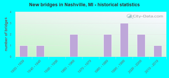
- New bridges - historical statistics
- 11930-1939
- 11940-1949
- 21960-1969
- 21980-1989
- 31990-1999
- 22000-2009
- 12010-2019


- Bridge Condition - Deck
- 11.1%Very good
- 44.4%Good
- 11.1%Satisfactory
- 22.2%Fair
- 11.1%Poor

- Bridge Condition - Superstructure
- 11.1%Excellent
- 22.2%Good
- 44.4%Satisfactory
- 22.2%Fair

- Bridge Condition - Substructure
- 33.3%Very good
- 11.1%Good
- 22.2%Satisfactory
- 22.2%Fair
- 11.1%Serious

- Bridge Condition - Channel
- 25.0%Good
- 58.3%Satisfactory
- 16.7%Fair

- Bridge Condition - Culverts
- 66.7%Good
- 33.3%Serious
Find on map >> Show street view
Structure Number: 543, Location: 1.9 MI S OF NASHVILLE (Lat: 42.577922, Lng: -85.094175), Route carried "on" structure: State highway 66, Year Built: 1940, Status: Open, Structure Length: 0.94m (3.08ft), Average Daily Traffic: 3,666 (year 2007), Truck Traffic: 9%, Average Future Daily Traffic: 5,361 (year 2018), Design Load: H 20, Features Intersected: QUAKER BROOK
Minimum Vertical Clearance: 30.48m (100.00ft), Kilometerpoint: 5.047, Lanes on structure: 2, Base Highway Network: Yes (Inventory Route: 98, Subroute: 3), Owner: State Highway Agency, Approaching Roadway Width: 11.9m (39.0ft), Material/Design: Steel, Design/Construction: Stringer/Multi-beam, Number Of Spans In Main Unit: 1, Length of Maximum Span: 9.4m (30.8ft), Curb-To-Curb Width: 11.5m (37.7ft), Out-to-Out Width: 12.3m (40.4ft)
Condition: Deck: Poor, Superstructure: Satisfactory, Substructure: Fair, Channel: Fair, Operating Rating: 64.8 metric tons, Method Used To Determine Operating Rating: Load Factor (LF) rating reported by rating factor (RF) method using MS18 loading, Inventory Rating: 38.9 metric tons, Method Used To Determine Inventory Rating: Load Factor (LF) rating reported by rating factor (RF) method using MS18 loading, Structural Evaluation: Somewhat better than minimum adequacy, Deck Geometry: Somewhat better than minimum adequacy, Waterway Adequacy: Equal to present desirable criteria, Approach Roadway Alignment: Equal to present desirable criteria, Designated Inspection Frequency: Every 24 months, Inspection Date: May 2020, Deck Structure Type: Concrete Cast-file-Place, Wearing Surface/Protective System: Wearing Surface: Bituminous
Find on map >> Show street view
Structure Number: 544, Location: IN VILLAGE OF NASHVILLE (Lat: 42.600181, Lng: -85.093661), Route carried "on" structure: State highway 66, Year Built: 2019, Status: Open, Structure Length: 1.40m (4.59ft), Average Daily Traffic: 6,083 (year 2015), Truck Traffic: 9%, Average Future Daily Traffic: 6,995 (year 2035), Design Load: Greater than HL93, Features Intersected: QUAKER BROOK
Minimum Vertical Clearance: 30.48m (100.00ft), Kilometerpoint: 7.538, Lanes on structure: 2, Base Highway Network: Yes (Inventory Route: 98, Subroute: 3), Owner: State Highway Agency, Approaching Roadway Width: 11.4m (37.4ft), Material/Design: Steel, Design/Construction: Stringer/Multi-beam, Number Of Spans In Main Unit: 1, Length of Maximum Span: 14.0m (45.9ft), Curb or Sidewalk Widths: Left: 1.6m (5.2ft), Right: 1.6m (5.2ft), Curb-To-Curb Width: 11.4m (37.4ft), Out-to-Out Width: 15.5m (50.9ft)
Condition: Deck: Very good, Superstructure: Excellent, Substructure: Very good, Channel: Good, Operating Rating: 79.4 metric tons, Method Used To Determine Operating Rating: Load and Resistance Factor Rating (LRFR) rating reported by rating factor(RF) method using HL-93 loadings, Inventory Rating: 61.2 metric tons, Method Used To Determine Inventory Rating: Load and Resistance Factor Rating (LRFR) rating reported by rating factor(RF) method using HL-93 loadings, Structural Evaluation: Equal to present desirable criteria, Deck Geometry: Meets minimum limits, Waterway Adequacy: Equal to present desirable criteria, Approach Roadway Alignment: Better than present minimum criteria, Designated Inspection Frequency: Every 24 months, Inspection Date: April 2021, Deck Structure Type: Concrete Cast-file-Place, Wearing Surface/Protective System: Wearing Surface: Epoxy Overlay, Deck Protection: Epoxy Coated Reinforcing
Find on map >> Show street view
Structure Number: 545, Location: IN NASHVILLE (Lat: 42.608700, Lng: -85.093344), Route carried "on" structure: State highway 66, Year Built: 1999, Status: Open, Structure Length: 4.07m (13.35ft), Average Daily Traffic: 6,177 (year 2007), Truck Traffic: 4%, Average Future Daily Traffic: 8,100 (year 2029), Design Load: HS 25 or greater, Features Intersected: THORNAPPLE RIVER
Minimum Vertical Clearance: 30.48m (100.00ft), Kilometerpoint: 8.485, Lanes on structure: 2, Base Highway Network: Yes (Inventory Route: 98, Subroute: 3), Owner: State Highway Agency, Approaching Roadway Width: 12.8m (42.0ft), Material/Design: Prestressed concrete, Design/Construction: Stringer/Multi-beam, Number Of Spans In Main Unit: 2, Length of Maximum Span: 20.3m (66.6ft), Curb or Sidewalk Widths: Left: 1.5m (4.9ft), Right: 1.5m (4.9ft), Curb-To-Curb Width: 12.8m (42.0ft), Out-to-Out Width: 16.5m (54.1ft)
Condition: Deck: Good, Superstructure: Good, Substructure: Satisfactory, Channel: Good, Operating Rating: 68.7 metric tons, Method Used To Determine Operating Rating: Load Factor (LF) rating reported by rating factor (RF) method using MS18 loading, Inventory Rating: 29.5 metric tons, Method Used To Determine Inventory Rating: Load Factor (LF) rating reported by rating factor (RF) method using MS18 loading, Structural Evaluation: Equal to present minimum criteria, Deck Geometry: Somewhat better than minimum adequacy, Waterway Adequacy: Equal to present desirable criteria, Approach Roadway Alignment: Better than present minimum criteria, Designated Inspection Frequency: Every 24 months, Underwater Inspection Frequency: Every 60 months, Other Special Inspection Frequency: Every 60 months, Inspection Date: May 2020, Underwater Inspection Date: June 2017, Other Special Inspection Date: June 2019, Deck Structure Type: Concrete Cast-file-Place, Wearing Surface/Protective System: Wearing Surface: Epoxy Overlay, Deck Protection: Epoxy Coated Reinforcing
Find on map >> Show street view
Structure Number: 55, Location: 0.3 MI E OF DEVINE ROAD (Lat: 42.624425, Lng: -85.146717), Route carried "on" structure: County highway , Year Built: 1961, Status: Open, Structure Length: 3.05m (10.01ft), Average Daily Traffic: 791 (year 2018), Truck Traffic: 2%, Average Future Daily Traffic: 965 (year 2038), Design Load: HS 20+Mod, Features Intersected: THORNAPPLE RIVER, Facility Carried by Structure: THORNAPPLE LAKE RD
Minimum Vertical Clearance: 30.48m (100.00ft), Kilometerpoint: 4.838, Lanes on structure: 2, Owner: County Highway Agency, Approaching Roadway Width: 10.1m (33.1ft), Material/Design: Prestressed concrete, Design/Construction: Box Beam or Girders - Multiple, Number Of Spans In Main Unit: 3, Length of Maximum Span: 12.2m (40.0ft), Curb-To-Curb Width: 9.5m (31.2ft), Out-to-Out Width: 10.1m (33.1ft)
Condition: Deck: Good, Superstructure: Satisfactory, Substructure: Satisfactory, Channel: Satisfactory, Operating Rating: 54.4 metric tons, Method Used To Determine Operating Rating: Load Factor (LF) rating reported by rating factor (RF) method using MS18 loading, Inventory Rating: 32.7 metric tons, Method Used To Determine Inventory Rating: Load Factor (LF) rating reported by rating factor (RF) method using MS18 loading, Structural Evaluation: Equal to present minimum criteria, Deck Geometry: Equal to present minimum criteria, Waterway Adequacy: Better than present minimum criteria, Approach Roadway Alignment: Equal to present minimum criteria, Designated Inspection Frequency: Every 24 months, Inspection Date: July 2021, Deck Structure Type: Concrete Precast Panels, Wearing Surface/Protective System: Wearing Surface: Bituminous, Membrane: Preformed Fabric
Find on map >> Show street view
Structure Number: 552, Location: 7.5 MI E OF HASTINGS (Lat: 42.641289, Lng: -85.144239), Route carried "on" structure: County highway , Year Built: 1992, Status: Posted for load, Structure Length: 2.13m (6.99ft), Average Daily Traffic: 720 (year 2003), Average Future Daily Traffic: 1,055 (year 2025), Design Load: HS 20, Features Intersected: MUD CREEK, Facility Carried by Structure: STATE ROAD
Minimum Vertical Clearance: 30.48m (100.00ft), Kilometerpoint: 1.120, Lanes on structure: 2, Owner: County Highway Agency, Approaching Roadway Width: 10.1m (33.1ft), Skew: 1 degrees, Material/Design: Prestressed concrete, Design/Construction: Box Beam or Girders - Multiple, Number Of Spans In Main Unit: 1, Length of Maximum Span: 21.3m (69.9ft), Curb-To-Curb Width: 10.1m (33.1ft), Out-to-Out Width: 10.4m (34.1ft)
Condition: Deck: Good, Superstructure: Satisfactory, Substructure: Very good, Channel: Satisfactory, Operating Rating: 47.6 metric tons, Method Used To Determine Operating Rating: Load Factor (LF) rating reported by rating factor (RF) method using MS18 loading, Inventory Rating: 28.5 metric tons, Method Used To Determine Inventory Rating: Load Factor (LF) rating reported by rating factor (RF) method using MS18 loading, Structural Evaluation: Equal to present minimum criteria, Deck Geometry: Equal to present minimum criteria, Waterway Adequacy: Equal to present desirable criteria, Approach Roadway Alignment: Equal to present minimum criteria, Bridge Posting: Required (Relationship of Operating Rating to Maximum Legal Load: 10.0 - 19.9% below), Designated Inspection Frequency: Every 24 months, Inspection Date: July 2021, Deck Structure Type: Concrete Precast Panels, Wearing Surface/Protective System: Wearing Surface: Bituminous, Membrane: Built-up
Find on map >> Show street view
Structure Number: 565, Location: 6.7 M E 1 M S OF HASTINGS (Lat: 42.631128, Lng: -85.161061), Route carried "on" structure: County highway , Year Built: 1991, Status: Posted for load, Structure Length: 2.53m (8.30ft), Average Daily Traffic: 294 (year 2018), Truck Traffic: 2%, Average Future Daily Traffic: 359 (year 2038), Design Load: HS 20, Features Intersected: THORNAPPLE RIVER, Facility Carried by Structure: BARGER ROAD
Minimum Vertical Clearance: 30.48m (100.00ft), Kilometerpoint: 0.674, Lanes on structure: 2, Owner: County Highway Agency, Approaching Roadway Width: 9.1m (29.9ft), Skew: 1 degrees, Material/Design: Prestressed concrete, Design/Construction: Box Beam or Girders - Multiple, Number Of Spans In Main Unit: 1, Length of Maximum Span: 25.3m (83.0ft), Curb-To-Curb Width: 10.0m (32.8ft), Out-to-Out Width: 10.5m (34.4ft)
Condition: Deck: Good, Superstructure: Good, Substructure: Very good, Channel: Satisfactory, Operating Rating: 48.9 metric tons, Method Used To Determine Operating Rating: Load Factor (LF) rating reported by rating factor (RF) method using MS18 loading, Inventory Rating: 29.5 metric tons, Method Used To Determine Inventory Rating: Load Factor (LF) rating reported by rating factor (RF) method using MS18 loading, Structural Evaluation: Better than present minimum criteria, Deck Geometry: Better than present minimum criteria, Waterway Adequacy: Equal to present desirable criteria, Approach Roadway Alignment: Equal to present desirable criteria, Bridge Posting: Required (Relationship of Operating Rating to Maximum Legal Load: 10.0 - 19.9% below), Designated Inspection Frequency: Every 24 months, Inspection Date: July 2021, Deck Structure Type: Concrete Precast Panels, Wearing Surface/Protective System: Wearing Surface: Bituminous, Membrane: Preformed Fabric
Find on map >> Show street view
Structure Number: 566, Location: 0.8 M N THORNAPPLE LK RD (Lat: 42.636014, Lng: -85.160119), Route carried "on" structure: County highway , Year Built: 1963, Status: Posted for load, Structure Length: 1.00m (3.28ft), Average Daily Traffic: 746 (year 2005), Average Future Daily Traffic: 1,090 (year 2025), Design Load: H 20, Features Intersected: MUD CREEK, Facility Carried by Structure: BARGER ROAD
Minimum Vertical Clearance: 30.48m (100.00ft), Kilometerpoint: 1.218, Lanes on structure: 2, Owner: County Highway Agency, Approaching Roadway Width: 9.1m (29.9ft), Material/Design: Steel, Design/Construction: Culvert, Number Of Spans In Main Unit: 4, Length of Maximum Span: 2.0m (6.6ft)
Condition: Channel: Fair, Culverts: Serious, Operating Rating: 24.9 metric tons, Method Used To Determine Operating Rating: Allowable Stress (AS), Inventory Rating: 18.7 metric tons, Method Used To Determine Inventory Rating: Allowable Stress (AS), Structural Evaluation: High priority of corrective action, Waterway Adequacy: Meets minimum limits, Approach Roadway Alignment: Equal to present minimum criteria, Bridge Posting: Required (Relationship of Operating Rating to Maximum Legal Load: > 39.9% below), Length Of Structure Improvement: 1.98m (6.50ft), Designated Inspection Frequency: Every 12 months, Inspection Date: July 2021, Bridge Improvement Cost: $340,000, Roadway Improvement Cost: $110,000, Total Project Cost: $450,000
Find on map >> Show street view
Structure Number: 578, Location: VILLAGE OF NASHVILLE (Lat: 42.598664, Lng: -85.086089), Route carried "on" structure: County highway , Year Built: 1985, Status: Open, Structure Length: 1.52m (4.99ft), Average Daily Traffic: 277 (year 2003), Average Future Daily Traffic: 333 (year 2023), Design Load: HS 20+Mod, Features Intersected: QUAKER BROOK, Facility Carried by Structure: FRANCIS STREET
Minimum Vertical Clearance: 30.48m (100.00ft), Kilometerpoint: 0.710, Lanes on structure: 2, Owner: City or Municipal Highway Agency, Approaching Roadway Width: 6.1m (20.0ft), Material/Design: Prestressed concrete, Design/Construction: Box Beam or Girders - Multiple, Number Of Spans In Main Unit: 1, Length of Maximum Span: 15.2m (49.9ft), Curb-To-Curb Width: 9.1m (29.9ft), Out-to-Out Width: 9.4m (30.8ft)
Condition: Deck: Satisfactory, Superstructure: Satisfactory, Substructure: Good, Channel: Satisfactory, Operating Rating: 50.9 metric tons, Method Used To Determine Operating Rating: Load and Resistance Factor Rating (LRFR) rating reported by rating factor(RF) method using HL-93 loadings, Inventory Rating: 39.2 metric tons, Method Used To Determine Inventory Rating: Load and Resistance Factor Rating (LRFR) rating reported by rating factor(RF) method using HL-93 loadings, Structural Evaluation: Equal to present minimum criteria, Deck Geometry: Equal to present minimum criteria, Waterway Adequacy: Equal to present desirable criteria, Approach Roadway Alignment: Equal to present desirable criteria, Designated Inspection Frequency: Every 24 months, Inspection Date: June 2021, Deck Structure Type: Concrete Cast-file-Place, Wearing Surface/Protective System: Wearing Surface: Bituminous, Membrane: Built-up
Find on map >> Show street view
Structure Number: 2764, Location: BET SILVER LAKE & ROLSTON (Lat: 42.804072, Lng: -83.854561), Route carried "on" structure: County highway , Year Built: 1932, Status: Posted for load, Structure Length: 1.37m (4.49ft), Average Daily Traffic: 827 (year 2012), Truck Traffic: 5%, Average Future Daily Traffic: 1,494 (year 2032), Design Load: HS 20+Mod, Features Intersected: SHIAWASSEE RIVER, Facility Carried by Structure: MCCASLIN ROAD
Minimum Vertical Clearance: 30.48m (100.00ft), Kilometerpoint: 1.090, Lanes on structure: 2, Owner: County Highway Agency, Approaching Roadway Width: 10.1m (33.1ft), Material/Design: Steel, Design/Construction: Stringer/Multi-beam, Number Of Spans In Main Unit: 1, Length of Maximum Span: 13.1m (43.0ft), Curb-To-Curb Width: 7.9m (25.9ft), Out-to-Out Width: 9.1m (29.9ft)
Condition: Deck: Fair, Superstructure: Fair, Substructure: Fair, Channel: Satisfactory, Operating Rating: 39.9 metric tons, Method Used To Determine Operating Rating: Load Factor (LF) rating reported by rating factor (RF) method using MS18 loading, Inventory Rating: 24.0 metric tons, Method Used To Determine Inventory Rating: Load Factor (LF) rating reported by rating factor (RF) method using MS18 loading, Structural Evaluation: Somewhat better than minimum adequacy, Deck Geometry: Somewhat better than minimum adequacy, Waterway Adequacy: Better than present minimum criteria, Approach Roadway Alignment: Equal to present desirable criteria, Bridge Posting: Required (Relationship of Operating Rating to Maximum Legal Load: 10.0 - 19.9% below), Designated Inspection Frequency: Every 24 months, Inspection Date: November 2020, Deck Structure Type: Concrete Cast-file-Place, Wearing Surface/Protective System: Wearing Surface: Bituminous
Find on map >> Show street view
Structure Number: 1329, Location: 1.0 MI W OF EATON CO LINE (Lat: 42.567386, Lng: -85.093875), Route carried "on" structure: State highway 79, Year Built: 2006, Status: Open, Structure Length: 0.84m (2.76ft), Average Daily Traffic: 2,415 (year 2007), Truck Traffic: 8%, Average Future Daily Traffic: 4,200 (year 2026), Design Load: HS 25 or greater, Features Intersected: TRIBUTARY - QUAKER BROOK
Minimum Vertical Clearance: 30.48m (100.00ft), Kilometerpoint: 0.103, Lanes on structure: 2, Base Highway Network: Yes (Inventory Route: 308, Subroute: 77), Owner: State Highway Agency, Approaching Roadway Width: 17.8m (58.4ft), Skew: 6 degrees, Material/Design: Concrete, Design/Construction: Culvert, Number Of Spans In Main Unit: 1, Length of Maximum Span: 8.4m (27.6ft), Curb-To-Curb Width: 17.8m (58.4ft), Out-to-Out Width: 67.1m (220.1ft)
Condition: Channel: Satisfactory, Culverts: Good, Operating Rating: 97.2 metric tons, Method Used To Determine Operating Rating: Load Factor (LF) rating reported by rating factor (RF) method using MS18 loading, Inventory Rating: 63.5 metric tons, Method Used To Determine Inventory Rating: Load Factor (LF) rating reported by rating factor (RF) method using MS18 loading, Structural Evaluation: Better than present minimum criteria, Deck Geometry: Superior to present desirable criteria, Waterway Adequacy: Superior to present desirable criteria, Approach Roadway Alignment: Equal to present desirable criteria, Designated Inspection Frequency: Every 24 months, Inspection Date: March 2021
Find on map >> Show street view
Structure Number: 13356, Location: 2.5 MI S OF NASHVILLE (Lat: 42.567353, Lng: -85.095283), Route carried "on" structure: State highway 66, Year Built: 2006, Status: Open, Structure Length: 1.37m (4.49ft), Average Daily Traffic: 2,159 (year 2007), Truck Traffic: 7%, Average Future Daily Traffic: 7,500 (year 2026), Design Load: HS 25 or greater, Features Intersected: QUAKER BROOK
Minimum Vertical Clearance: 30.48m (100.00ft), Kilometerpoint: 3.858, Lanes on structure: 4, Base Highway Network: Yes (Inventory Route: 98, Subroute: 3), Owner: State Highway Agency, Approaching Roadway Width: 24.2m (79.4ft), Skew: 2 degrees, Material/Design: Concrete, Design/Construction: Culvert, Number Of Spans In Main Unit: 1, Length of Maximum Span: 13.7m (44.9ft), Curb-To-Curb Width: 24.2m (79.4ft), Out-to-Out Width: 35.7m (117.1ft)
Condition: Channel: Good, Culverts: Good, Operating Rating: 63.2 metric tons, Method Used To Determine Operating Rating: Load Factor (LF) rating reported by rating factor (RF) method using MS18 loading, Inventory Rating: 37.3 metric tons, Method Used To Determine Inventory Rating: Load Factor (LF) rating reported by rating factor (RF) method using MS18 loading, Structural Evaluation: Better than present minimum criteria, Deck Geometry: Superior to present desirable criteria, Waterway Adequacy: Superior to present desirable criteria, Approach Roadway Alignment: Equal to present desirable criteria, Designated Inspection Frequency: Every 24 months, Inspection Date: March 2021
Find on map >> Show street view
Structure Number: 13383, Location: MAPLE GROVE TWP SEC 11 (Lat: 42.574361, Lng: -85.095336), Route carried "on" structure: County highway , Year Built: 1988, Status: Posted for load, Structure Length: 0.69m (2.26ft), Average Daily Traffic: 10 (year 2006), Average Future Daily Traffic: 10 (year 2006), Design Load: HS 20, Features Intersected: QUAKER BROOK, Facility Carried by Structure: QUAKER BROOK LANE
Minimum Vertical Clearance: 30.48m (100.00ft), Kilometerpoint: 0.098, Lanes on structure: 1, Owner: County Highway Agency, Approaching Roadway Width: 4.9m (16.1ft), Material/Design: Steel, Design/Construction: Stringer/Multi-beam, Number Of Spans In Main Unit: 1, Length of Maximum Span: 6.6m (21.7ft), Curb-To-Curb Width: 4.9m (16.1ft), Out-to-Out Width: 4.9m (16.1ft)
Condition: Deck: Fair, Superstructure: Fair, Substructure: Serious, Channel: Satisfactory, Operating Rating: 27.2 metric tons, Method Used To Determine Operating Rating: Load Factor (LF) rating reported by rating factor (RF) method using MS18 loading, Inventory Rating: 16.2 metric tons, Method Used To Determine Inventory Rating: Load Factor (LF) rating reported by rating factor (RF) method using MS18 loading, Structural Evaluation: High priority of corrective action, Deck Geometry: High priority of corrective action, Waterway Adequacy: Equal to present minimum criteria, Approach Roadway Alignment: Equal to present minimum criteria, Bridge Posting: Required (Relationship of Operating Rating to Maximum Legal Load: 30.0 - 39.9% below), Designated Inspection Frequency: Every 6 months, Inspection Date: January 2022, Deck Structure Type: Concrete Cast-file-Place, Wearing Surface/Protective System: Wearing Surface: Monolithic Concrete