Bridge Statistics for Natchez, Louisiana (LA)
Condition, Traffic, Stress, Structural Evaluation, Project Costs
- National Bridge Inventory (NBI) Statistics
- 12Number of bridges
- 174ft / 52.5mTotal length
- 36,147Total average daily traffic
- 9,799Total average daily truck traffic
- National Bridge Inventory (NBI) Registered Bridges for Natchez
- No street view available for this location
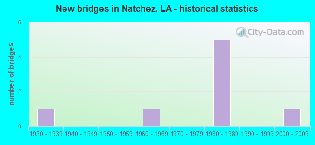
- New bridges - historical statistics
- 11930-1939
- 11960-1969
- 51980-1989
- 12000-2009


- Bridge Condition - Superstructure
- 50.0%Very good
- 50.0%Good

- Bridge Condition - Substructure
- 33.3%Very good
- 66.7%Good

- Bridge Condition - Channel
- 83.3%Good
- 16.7%Satisfactory
Find on map >> Show street view
Structure Number: 83500420710551, Location: .4 MI. E OF INT I-49 (Lat: 31.610361, Lng: -93.042400), Route carried "on" structure: State highway 120, Year Built: 1985, Status: Open, Structure Length: 9.75m (31.99ft), Average Daily Traffic: 47 (year 2016), Truck Traffic: 14%, Average Future Daily Traffic: 39 (year 2036), Design Load: HS 20, Features Intersected: OLD RIVER
Minimum Vertical Clearance: 30+ m (98+ ft), Kilometerpoint: 16.795, Lanes on structure: 2, Owner: State Highway Agency, Approaching Roadway Width: 13.4m (44.0ft), Skew: 34 degrees, Material/Design: Concrete, Design/Construction: Slab, Number Of Spans In Main Unit: 16, Length of Maximum Span: 6.1m (20.0ft), Curb-To-Curb Width: 13.4m (44.0ft), Out-to-Out Width: 14.3m (46.9ft)
Condition: Deck: Good, Superstructure: Good, Substructure: Very good, Channel: Good, Operating Rating: 67.1 metric tons, Method Used To Determine Operating Rating: Load Factor (LF), Inventory Rating: 39.9 metric tons, Method Used To Determine Inventory Rating: Load Factor (LF), Structural Evaluation: Better than present minimum criteria, Deck Geometry: Superior to present desirable criteria, Waterway Adequacy: Better than present minimum criteria, Approach Roadway Alignment: Equal to present desirable criteria, Designated Inspection Frequency: Every 24 months, Inspection Date: March 2020, Deck Structure Type: Concrete Cast-file-Place, Wearing Surface/Protective System: Wearing Surface: Monolithic Concrete
Find on map >> Show street view
Structure Number: 83500530409301, Location: 1.2 MI. N OF N INT LA119 (Lat: 31.693739, Lng: -93.049000), Route carried "on" structure: State highway 1, Year Built: 1936, Status: Open, Structure Length: 0.76m (2.49ft), Average Daily Traffic: 5,300 (year 2016), Truck Traffic: 14%, Average Future Daily Traffic: 3,744 (year 2036), Design Load: H 15, Features Intersected: DITCH
Minimum Vertical Clearance: 30+ m (98+ ft), Kilometerpoint: 14.886, Lanes on structure: 2, Owner: State Highway Agency, Approaching Roadway Width: 12.2m (40.0ft), Skew: 30 degrees, Material/Design: Concrete, Design/Construction: Culvert, Number Of Spans In Main Unit: 4, Length of Maximum Span: 1.5m (4.9ft)
Condition: Channel: Good, Culverts: Satisfactory, Operating Rating: 42.1 metric tons, Method Used To Determine Operating Rating: Load and Resistance Factor Rating (LRFR) rating reported by rating factor(RF) method using HL-93 loadings, Inventory Rating: 32.4 metric tons, Method Used To Determine Inventory Rating: Load and Resistance Factor Rating (LRFR) rating reported by rating factor(RF) method using HL-93 loadings, Structural Evaluation: Equal to present minimum criteria, Waterway Adequacy: Better than present minimum criteria, Approach Roadway Alignment: Equal to present desirable criteria, Designated Inspection Frequency: Every 24 months, Inspection Date: April 2020, Deck Structure Type: Concrete Cast-file-Place
Find on map >> Show street view
Structure Number: 83503600501521, Location: 1.52 MI. E OF INT LA1 (Lat: 31.635139, Lng: -93.023789), Route carried "on" structure: State highway 494, Year Built: 1963, Status: Open, Structure Length: 0.70m (2.30ft), Average Daily Traffic: 580 (year 2016), Truck Traffic: 14%, Average Future Daily Traffic: 446 (year 2036), Design Load: H 15, Features Intersected: CREEK
Minimum Vertical Clearance: 30+ m (98+ ft), Kilometerpoint: 2.446, Lanes on structure: 2, Owner: State Highway Agency, Approaching Roadway Width: 8.2m (26.9ft), Skew: 30 degrees, Material/Design: Concrete, Design/Construction: Culvert, Number Of Spans In Main Unit: 5, Length of Maximum Span: 1.2m (3.9ft)
Condition: Channel: Satisfactory, Culverts: Satisfactory, Operating Rating: 29.5 metric tons, Method Used To Determine Operating Rating: Load and Resistance Factor Rating (LRFR) rating reported by rating factor(RF) method using HL-93 loadings, Inventory Rating: 22.7 metric tons, Method Used To Determine Inventory Rating: Load and Resistance Factor Rating (LRFR) rating reported by rating factor(RF) method using HL-93 loadings, Structural Evaluation: Equal to present minimum criteria, Waterway Adequacy: Equal to present minimum criteria, Approach Roadway Alignment: Equal to present desirable criteria, Designated Inspection Frequency: Every 24 months, Inspection Date: April 2020, Deck Structure Type: Concrete Cast-file-Place
Find on map >> Show street view
Structure Number: 83504550618841, Location: I-49 / LA 120 INTG. (Lat: 31.608961, Lng: -93.049200), Route carried "on" structure: Interstate 49, Year Built: 1988, Status: Open, Structure Length: 8.72m (28.61ft), Average Daily Traffic: 7,450 (year 2016), Truck Traffic: 30%, Average Future Daily Traffic: 6,307 (year 2036), Design Load: HS 20, Features Intersected: LA 120
Minimum Vertical Clearance: 30+ m (98+ ft), Kilometerpoint: 30.391, Lanes on structure: 2, Lanes under structure: 4, Base Highway Network: Yes (Inventory Route: 455-06-1, Subroute: 10), Owner: State Highway Agency, Approaching Roadway Width: 11.9m (39.0ft), Skew: 36 degrees, Material/Design: Prestressed concrete continuous, Design/Construction: Stringer/Multi-beam, Number Of Spans In Main Unit: 2, Number Of Approach Spans: 2, Length of Maximum Span: 26.5m (86.9ft), Curb-To-Curb Width: 12.2m (40.0ft), Out-to-Out Width: 13.0m (42.7ft)
Condition: Deck: Good, Superstructure: Very good, Substructure: Good, Operating Rating: 70.7 metric tons, Method Used To Determine Operating Rating: Load Factor (LF), Inventory Rating: 39.0 metric tons, Method Used To Determine Inventory Rating: Load Factor (LF), Structural Evaluation: Better than present minimum criteria, Deck Geometry: Better than present minimum criteria, Underclear: Better than present minimum criteria, Approach Roadway Alignment: Equal to present desirable criteria, Designated Inspection Frequency: Every 24 months, Inspection Date: June 2020, Deck Structure Type: Concrete Cast-file-Place, Wearing Surface/Protective System: Wearing Surface: Monolithic Concrete
Find on map >> Show street view
Structure Number: 83504550618842, Location: I-49 / LA 120 INTG. (Lat: 31.609531, Lng: -93.050100), Route carried "on" structure: Interstate 49, Year Built: 1988, Status: Open, Structure Length: 8.72m (28.61ft), Average Daily Traffic: 7,450 (year 2016), Truck Traffic: 30%, Average Future Daily Traffic: 6,307 (year 2036), Design Load: HS 20, Features Intersected: LA 120
Minimum Vertical Clearance: 30+ m (98+ ft), Kilometerpoint: 51.124, Lanes on structure: 2, Lanes under structure: 4, Base Highway Network: Yes (Inventory Route: 455-06-2, Subroute: 10), Owner: State Highway Agency, Approaching Roadway Width: 11.9m (39.0ft), Skew: 36 degrees, Material/Design: Prestressed concrete continuous, Design/Construction: Stringer/Multi-beam, Number Of Spans In Main Unit: 2, Number Of Approach Spans: 2, Length of Maximum Span: 26.5m (86.9ft), Curb-To-Curb Width: 12.2m (40.0ft), Out-to-Out Width: 13.0m (42.7ft)
Condition: Deck: Good, Superstructure: Good, Substructure: Good, Operating Rating: 70.7 metric tons, Method Used To Determine Operating Rating: Load Factor (LF), Inventory Rating: 39.0 metric tons, Method Used To Determine Inventory Rating: Load Factor (LF), Structural Evaluation: Better than present minimum criteria, Deck Geometry: Better than present minimum criteria, Underclear: Better than present minimum criteria, Approach Roadway Alignment: Equal to present desirable criteria, Designated Inspection Frequency: Every 24 months, Inspection Date: June 2020, Deck Structure Type: Concrete Cast-file-Place, Wearing Surface/Protective System: Wearing Surface: Monolithic Concrete
Find on map >> Show street view
Structure Number: 83504550620161, Location: 1.13 MI. NORTH OF LA 120 (Lat: 31.623911, Lng: -93.063300), Route carried "on" structure: Interstate 49, Year Built: 1988, Status: Open, Structure Length: 10.21m (33.50ft), Average Daily Traffic: 7,500 (year 2016), Truck Traffic: 30%, Average Future Daily Traffic: 6,264 (year 2036), Design Load: HS 20, Features Intersected: B.JULIAN/LONGLOIS HILL
Minimum Vertical Clearance: 30+ m (98+ ft), Kilometerpoint: 32.518, Lanes on structure: 2, Lanes under structure: 2, Base Highway Network: Yes (Inventory Route: 455-06-1, Subroute: 10), Owner: State Highway Agency, Approaching Roadway Width: 12.2m (40.0ft), Skew: 34 degrees, Material/Design: Prestressed concrete continuous, Design/Construction: Stringer/Multi-beam, Number Of Spans In Main Unit: 5, Length of Maximum Span: 20.4m (66.9ft), Curb-To-Curb Width: 12.2m (40.0ft), Out-to-Out Width: 13.0m (42.7ft)
Condition: Deck: Good, Superstructure: Very good, Substructure: Good, Channel: Good, Operating Rating: 63.5 metric tons, Method Used To Determine Operating Rating: Load Factor (LF), Inventory Rating: 38.1 metric tons, Method Used To Determine Inventory Rating: Load Factor (LF), Structural Evaluation: Better than present minimum criteria, Deck Geometry: Better than present minimum criteria, Underclear: High priority of corrective action, Waterway Adequacy: Equal to present desirable criteria, Approach Roadway Alignment: Equal to present desirable criteria, Designated Inspection Frequency: Every 24 months, Inspection Date: June 2020, Deck Structure Type: Concrete Cast-file-Place, Wearing Surface/Protective System: Wearing Surface: Monolithic Concrete
Find on map >> Show street view
Structure Number: 83504550620162, Location: 1.13 MI. NORTH OF LA 120 (Lat: 31.624661, Lng: -93.064300), Route carried "on" structure: Interstate 49, Year Built: 1988, Status: Open, Structure Length: 10.21m (33.50ft), Average Daily Traffic: 7,500 (year 2016), Truck Traffic: 30%, Average Future Daily Traffic: 6,264 (year 2036), Design Load: HS 20, Features Intersected: BAYOU JULIAN/PH RD 715
Minimum Vertical Clearance: 30+ m (98+ ft), Kilometerpoint: 48.971, Lanes on structure: 2, Lanes under structure: 2, Base Highway Network: Yes (Inventory Route: 455-06-2, Subroute: 10), Owner: State Highway Agency, Approaching Roadway Width: 12.2m (40.0ft), Skew: 34 degrees, Material/Design: Prestressed concrete continuous, Design/Construction: Stringer/Multi-beam, Number Of Spans In Main Unit: 5, Length of Maximum Span: 20.4m (66.9ft), Curb-To-Curb Width: 12.2m (40.0ft), Out-to-Out Width: 13.0m (42.7ft)
Condition: Deck: Good, Superstructure: Very good, Substructure: Good, Channel: Good, Operating Rating: 63.5 metric tons, Method Used To Determine Operating Rating: Load Factor (LF), Inventory Rating: 38.1 metric tons, Method Used To Determine Inventory Rating: Load Factor (LF), Structural Evaluation: Better than present minimum criteria, Deck Geometry: Better than present minimum criteria, Underclear: Better than present minimum criteria, Waterway Adequacy: Equal to present desirable criteria, Approach Roadway Alignment: Equal to present desirable criteria, Designated Inspection Frequency: Every 24 months, Inspection Date: June 2020, Deck Structure Type: Concrete Cast-file-Place, Wearing Surface/Protective System: Wearing Surface: Monolithic Concrete
Find on map >> Show street view
Structure Number: 83531394930411, Location: 0.02 M W OF OLD RIVER ROA (Lat: 31.656089, Lng: -93.067900), Route carried "on" structure: County highway , Year Built: 2000, Status: Open, Structure Length: 3.47m (11.38ft), Average Daily Traffic: 100 (year 1999), Average Future Daily Traffic: 72 (year 2036), Design Load: HS 20, Features Intersected: OLD RIVER, Facility Carried by Structure: Old River Rd
Minimum Vertical Clearance: 30+ m (98+ ft), Kilometerpoint: 0.000, Lanes on structure: 2, Owner: County Highway Agency, Approaching Roadway Width: 5.5m (18.0ft), Skew: 30 degrees, Material/Design: Concrete, Design/Construction: Slab, Number Of Spans In Main Unit: 6, Length of Maximum Span: 5.8m (19.0ft), Curb-To-Curb Width: 7.3m (24.0ft), Out-to-Out Width: 8.2m (26.9ft)
Condition: Deck: Good, Superstructure: Good, Substructure: Very good, Channel: Good, Operating Rating: 33.7 metric tons, Method Used To Determine Operating Rating: Load and Resistance Factor Rating (LRFR) rating reported by rating factor(RF) method using HL-93 loadings, Inventory Rating: 25.9 metric tons, Method Used To Determine Inventory Rating: Load and Resistance Factor Rating (LRFR) rating reported by rating factor(RF) method using HL-93 loadings, Structural Evaluation: Equal to present minimum criteria, Deck Geometry: Equal to present minimum criteria, Waterway Adequacy: Equal to present desirable criteria, Approach Roadway Alignment: Better than present minimum criteria, Designated Inspection Frequency: Every 24 months, Inspection Date: Febuary 2021, Deck Structure Type: Concrete Cast-file-Place, Wearing Surface/Protective System: Wearing Surface: Monolithic Concrete
Find on map >> Show street view
Structure Number: 83504550618841, Location: 1.1 MI W OF LA 1 (Lat: 31.609169, Lng: -93.049469), Route carried "under" structure: State highway 120, Structure Length: 0. m, Average Daily Traffic: 55 (year 2014), Features Intersected: LA 120 EB UNDER I-49 SB
Minimum Vertical Clearance: 4.94m (16.21ft), Kilometerpoint: 16.113, Lanes on structure: 2, Length of Maximum Span: 0.0m
Find on map >> Show street view
Structure Number: 83504550618841, Location: 1.1 MI W OF LA 1 (Lat: 31.609361, Lng: -93.049439), Route carried "under" structure: State highway 120, Structure Length: 0. m, Average Daily Traffic: 55 (year 2014), Features Intersected: LA 120 WB UNDER I-49 NB
Minimum Vertical Clearance: 5.12m (16.80ft), Kilometerpoint: 1.719, Lanes on structure: 2, Length of Maximum Span: 0.0m
Find on map >> Show street view
Structure Number: 83504550618842, Location: 1.1 MI W OF LA 1 (Lat: 31.609111, Lng: -93.049800), Route carried "under" structure: State highway 120, Structure Length: 0. m, Average Daily Traffic: 55 (year 2014), Features Intersected: LA 120 EB UNDER I-49 SB
Minimum Vertical Clearance: 4.97m (16.31ft), Kilometerpoint: 16.081, Lanes on structure: 2, Length of Maximum Span: 0.0m
Find on map >> Show street view
Structure Number: 83504550618842, Location: 1.1 MI W OF LA 1 (Lat: 31.609281, Lng: -93.049950), Route carried "under" structure: State highway 120, Structure Length: 0. m, Average Daily Traffic: 55 (year 2014), Features Intersected: LA 120 WB UNDER I-49 SB
Minimum Vertical Clearance: 4.97m (16.31ft), Kilometerpoint: 1.769, Lanes on structure: 2, Length of Maximum Span: 0.0m