Bridge Statistics for Natchez, Mississippi (MS)
Condition, Traffic, Stress, Structural Evaluation, Project Costs
- National Bridge Inventory (NBI) Statistics
- 37Number of bridges
- 1,732ft / 528mTotal length
- $5,310,185,000Total costs
- 238,320Total average daily traffic
- 19,160Total average daily truck traffic
- National Bridge Inventory (NBI) Registered Bridges for Natchez
- No street view available for this location
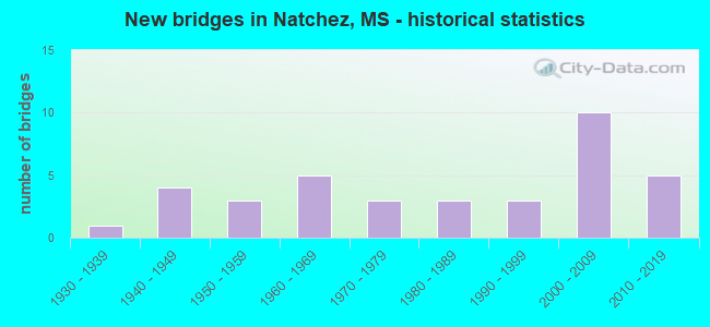
- New bridges - historical statistics
- 11930-1939
- 41940-1949
- 31950-1959
- 51960-1969
- 31970-1979
- 31980-1989
- 31990-1999
- 102000-2009
- 52010-2019
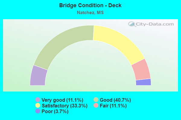
- Bridge Condition - Deck
- 11.1%Very good
- 40.7%Good
- 33.3%Satisfactory
- 11.1%Fair
- 3.7%Poor
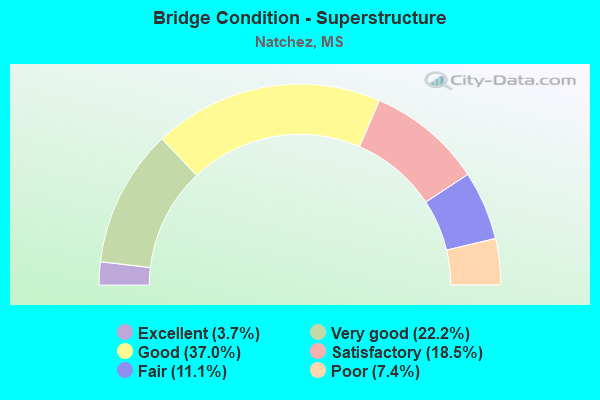
- Bridge Condition - Superstructure
- 3.7%Excellent
- 22.2%Very good
- 37.0%Good
- 18.5%Satisfactory
- 11.1%Fair
- 7.4%Poor
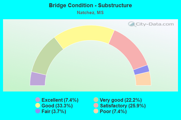
- Bridge Condition - Substructure
- 7.4%Excellent
- 22.2%Very good
- 33.3%Good
- 25.9%Satisfactory
- 3.7%Fair
- 7.4%Poor
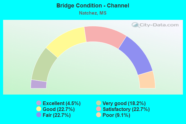
- Bridge Condition - Channel
- 4.5%Excellent
- 18.2%Very good
- 22.7%Good
- 22.7%Satisfactory
- 22.7%Fair
- 9.1%Poor
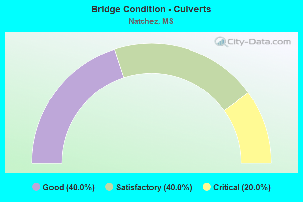
- Bridge Condition - Culverts
- 40.0%Good
- 40.0%Satisfactory
- 20.0%Critical
Find on map >> Show street view
Structure Number: 21000610010416A, Location: 0.6 MI S US 84 WEST (Lat: 31.521833, Lng: -91.389186), Route carried "on" structure: US 61, Year Built: 1960, Status: Open, Structure Length: 11.28m (37.01ft), Average Daily Traffic: 7,500 (year 2020), Truck Traffic: 12%, Average Future Daily Traffic: 7,500 (year 2040), Design Load: HS 20, Features Intersected: ST CATHERINE CREEK
Minimum Vertical Clearance: 30+ m (98+ ft), Kilometerpoint: 21.218, Lanes on structure: 2, Base Highway Network: Yes (Inventory Route: 6, Subroute: 2), Owner: State Highway Agency, Approaching Roadway Width: 8.5m (27.9ft), Material/Design: Steel continuous, Design/Construction: Stringer/Multi-beam, Number Of Spans In Main Unit: 3, Number Of Approach Spans: 4, Length of Maximum Span: 64.0m (210.0ft), Curb or Sidewalk Widths: Left: 0.5m (1.6ft), Right: 0.5m (1.6ft), Curb-To-Curb Width: 8.5m (27.9ft), Out-to-Out Width: 9.4m (30.8ft)
Condition: Deck: Good, Superstructure: Good, Substructure: Good, Channel: Fair, Operating Rating: 44.5 metric tons, Method Used To Determine Operating Rating: Load Factor (LF), Inventory Rating: 26.7 metric tons, Method Used To Determine Inventory Rating: Load Factor (LF), Structural Evaluation: Equal to present minimum criteria, Deck Geometry: High priority of corrective action, Waterway Adequacy: Equal to present desirable criteria, Approach Roadway Alignment: Equal to present desirable criteria, Length Of Structure Improvement: 11.28m (37.01ft), Designated Inspection Frequency: Every 24 months, Inspection Date: June 2020, Bridge Improvement Cost: $600,000,000, Roadway Improvement Cost: $200,000,000, Total Project Cost: $960,000,000, Deck Structure Type: Concrete Cast-file-Place
Find on map >> Show street view
Structure Number: 21000610010416B, Location: 0.6 MI S US 84 WEST (Lat: 31.521014, Lng: -91.388489), Route carried "on" structure: US 61, Year Built: 1978, Status: Open, Structure Length: 12.56m (41.21ft), Average Daily Traffic: 7,500 (year 2020), Truck Traffic: 13%, Average Future Daily Traffic: 7,500 (year 2040), Design Load: HS 20, Features Intersected: ST CATHERINE CREEK
Minimum Vertical Clearance: 30+ m (98+ ft), Kilometerpoint: 22.471, Lanes on structure: 2, Base Highway Network: Yes (Inventory Route: 6, Subroute: 1), Owner: State Highway Agency, Approaching Roadway Width: 11.8m (38.7ft), Material/Design: Prestressed concrete continuous, Design/Construction: Stringer/Multi-beam, Number Of Spans In Main Unit: 4, Number Of Approach Spans: 3, Length of Maximum Span: 27.4m (89.9ft), Curb-To-Curb Width: 11.8m (38.7ft), Out-to-Out Width: 12.7m (41.7ft)
Condition: Deck: Good, Superstructure: Good, Substructure: Good, Channel: Fair, Operating Rating: 50.2 metric tons, Method Used To Determine Operating Rating: Load Factor (LF), Inventory Rating: 29.0 metric tons, Method Used To Determine Inventory Rating: Load Factor (LF), Structural Evaluation: Better than present minimum criteria, Deck Geometry: Better than present minimum criteria, Waterway Adequacy: Equal to present desirable criteria, Approach Roadway Alignment: Equal to present desirable criteria, Designated Inspection Frequency: Every 24 months, Inspection Date: June 2020, Deck Structure Type: Concrete Cast-file-Place
Find on map >> Show street view
Structure Number: 21000610010434A, Location: 1.1 MI N US 84 WEST (Lat: 31.540603, Lng: -91.376942), Route carried "on" structure: US 61, Year Built: 1947, Status: Open, Structure Length: 4.88m (16.01ft), Average Daily Traffic: 12,500 (year 2020), Truck Traffic: 10%, Average Future Daily Traffic: 12,500 (year 2040), Design Load: HS 15, Features Intersected: CNIC RR
Minimum Vertical Clearance: 30+ m (98+ ft), Kilometerpoint: 18.569, Lanes on structure: 2, Base Highway Network: Yes (Inventory Route: 6, Subroute: 2), Owner: State Highway Agency, Approaching Roadway Width: 7.9m (25.9ft), Material/Design: Concrete, Design/Construction: Tee Beam, Number Of Spans In Main Unit: 1, Number Of Approach Spans: 4, Length of Maximum Span: 12.2m (40.0ft), Curb or Sidewalk Widths: Left: 1.1m (3.6ft), Right: 1.1m (3.6ft), Curb-To-Curb Width: 7.9m (25.9ft), Out-to-Out Width: 10.1m (33.1ft)
Condition: Deck: Good, Superstructure: Good, Substructure: Good, Operating Rating: 41.0 metric tons, Method Used To Determine Operating Rating: Load Factor (LF), Inventory Rating: 24.6 metric tons, Method Used To Determine Inventory Rating: Load Factor (LF), Structural Evaluation: Equal to present minimum criteria, Deck Geometry: High priority of replacement, Underclear: Meets minimum limits, Approach Roadway Alignment: Equal to present desirable criteria, Length Of Structure Improvement: 6.31m (20.70ft), Designated Inspection Frequency: Every 24 months, Inspection Date: June 2020, Bridge Improvement Cost: $576,000,000, Roadway Improvement Cost: $58,000,000, Total Project Cost: $999,999,000, Deck Structure Type: Concrete Cast-file-Place
Find on map >> Show street view
Structure Number: 21000610010434B, Location: 1.1 MI N US 84 WEST (Lat: 31.540231, Lng: -91.376967), Route carried "on" structure: US 61, Year Built: 1963, Status: Open, Structure Length: 4.88m (16.01ft), Average Daily Traffic: 12,500 (year 2020), Truck Traffic: 7%, Average Future Daily Traffic: 12,500 (year 2040), Design Load: HS 20, Features Intersected: CNIC RR
Minimum Vertical Clearance: 30+ m (98+ ft), Kilometerpoint: 25.180, Lanes on structure: 2, Base Highway Network: Yes (Inventory Route: 6, Subroute: 1), Owner: State Highway Agency, Approaching Roadway Width: 7.9m (25.9ft), Material/Design: Prestressed concrete, Design/Construction: Stringer/Multi-beam, Number Of Spans In Main Unit: 1, Number Of Approach Spans: 4, Length of Maximum Span: 12.2m (40.0ft), Curb or Sidewalk Widths: Left: 0.9m (3.0ft), Right: 0.9m (3.0ft), Curb-To-Curb Width: 7.9m (25.9ft), Out-to-Out Width: 10.1m (33.1ft)
Condition: Deck: Good, Superstructure: Very good, Substructure: Very good, Operating Rating: 59.0 metric tons, Method Used To Determine Operating Rating: Load Factor (LF), Inventory Rating: 29.8 metric tons, Method Used To Determine Inventory Rating: Load Factor (LF), Structural Evaluation: Better than present minimum criteria, Deck Geometry: High priority of replacement, Underclear: Meets minimum limits, Approach Roadway Alignment: Equal to present desirable criteria, Length Of Structure Improvement: 4.88m (16.01ft), Designated Inspection Frequency: Every 24 months, Inspection Date: June 2020, Bridge Improvement Cost: $130,000,000, Roadway Improvement Cost: $200,000,000, Total Project Cost: $336,000,000, Deck Structure Type: Concrete Cast-file-Place
Find on map >> Show street view
Structure Number: 2100061001044, Location: 1.7 MI N US 84 WEST (Lat: 31.547625, Lng: -91.373414), Route carried "on" structure: US 61, Year Built: 2007, Status: Open, Structure Length: 5.73m (18.80ft), Average Daily Traffic: 25,000 (year 2020), Truck Traffic: 7%, Average Future Daily Traffic: 25,000 (year 2040), Design Load: HS 20, Features Intersected: LIBERTY ROAD
Minimum Vertical Clearance: 30+ m (98+ ft), Kilometerpoint: 26.075, Lanes on structure: 6, Lanes under structure: 7, Base Highway Network: Yes (Inventory Route: 6, Subroute: 1), Owner: State Highway Agency, Approaching Roadway Width: 36.6m (120.1ft), Material/Design: Prestressed concrete continuous, Design/Construction: Stringer/Multi-beam, Number Of Spans In Main Unit: 2, Length of Maximum Span: 28.7m (94.2ft), Curb-To-Curb Width: 36.6m (120.1ft), Out-to-Out Width: 37.6m (123.4ft)
Condition: Deck: Satisfactory, Superstructure: Very good, Substructure: Very good, Operating Rating: 86.8 metric tons, Method Used To Determine Operating Rating: Load Factor (LF), Inventory Rating: 44.4 metric tons, Method Used To Determine Inventory Rating: Load Factor (LF), Structural Evaluation: Equal to present desirable criteria, Deck Geometry: Superior to present desirable criteria, Underclear: Superior to present desirable criteria, Approach Roadway Alignment: Equal to present desirable criteria, Designated Inspection Frequency: Every 24 months, Inspection Date: June 2020, Deck Structure Type: Concrete Cast-file-Place
Find on map >> Show street view
Structure Number: 21000610010448, Location: 3.2 MI S US 84E (Lat: 31.559919, Lng: -91.365003), Route carried "on" structure: US 61, Year Built: 2013, Status: Open, Structure Length: 32.08m (105.25ft), Average Daily Traffic: 26,000 (year 2020), Truck Traffic: 8%, Average Future Daily Traffic: 26,000 (year 2040), Design Load: HS 20, Features Intersected: US 61/DEVEREUX RD.
Minimum Vertical Clearance: 30+ m (98+ ft), Kilometerpoint: 16.510, Lanes on structure: 2, Lanes under structure: 4, Base Highway Network: Yes (Inventory Route: 6, Subroute: 1), Owner: State Highway Agency, Approaching Roadway Width: 13.4m (44.0ft), Material/Design: Concrete continuous, Design/Construction: Box Beam or Girders - Single/Spread, Number Of Spans In Main Unit: 9, Length of Maximum Span: 46.6m (152.9ft), Curb-To-Curb Width: 13.4m (44.0ft), Out-to-Out Width: 14.3m (46.9ft)
Condition: Deck: Very good, Superstructure: Very good, Substructure: Very good, Operating Rating: 54.0 metric tons, Method Used To Determine Operating Rating: Load Factor (LF), Inventory Rating: 32.4 metric tons, Method Used To Determine Inventory Rating: Load Factor (LF), Structural Evaluation: Equal to present desirable criteria, Deck Geometry: Superior to present desirable criteria, Underclear: Meets minimum limits, Approach Roadway Alignment: Equal to present desirable criteria, Designated Inspection Frequency: Every 24 months, Inspection Date: June 2020, Deck Structure Type: Concrete Cast-file-Place
Find on map >> Show street view
Structure Number: 21000610010452A, Location: 2.8 MI S US 84 EAST (Lat: 31.561528, Lng: -91.359672), Route carried "on" structure: US 61, Year Built: 1955, Status: Open, Structure Length: 16.73m (54.89ft), Average Daily Traffic: 16,500 (year 2020), Truck Traffic: 8%, Average Future Daily Traffic: 16,500 (year 2040), Design Load: HS 15, Features Intersected: ST CATHERINE CREEK
Minimum Vertical Clearance: 30+ m (98+ ft), Kilometerpoint: 15.976, Lanes on structure: 2, Base Highway Network: Yes (Inventory Route: 6, Subroute: 1), Owner: State Highway Agency, Approaching Roadway Width: 7.3m (24.0ft), Material/Design: Steel continuous, Design/Construction: Stringer/Multi-beam, Number Of Spans In Main Unit: 5, Number Of Approach Spans: 4, Length of Maximum Span: 29.0m (95.1ft), Curb or Sidewalk Widths: Left: 1.5m (4.9ft), Right: 0.5m (1.6ft), Curb-To-Curb Width: 7.3m (24.0ft), Out-to-Out Width: 9.9m (32.5ft)
Condition: Deck: Satisfactory, Superstructure: Satisfactory, Substructure: Good, Channel: Fair, Operating Rating: 39.6 metric tons, Method Used To Determine Operating Rating: Load Factor (LF), Inventory Rating: 23.8 metric tons, Method Used To Determine Inventory Rating: Load Factor (LF), Structural Evaluation: Somewhat better than minimum adequacy, Deck Geometry: High priority of replacement, Waterway Adequacy: Equal to present desirable criteria, Approach Roadway Alignment: Equal to present desirable criteria, Length Of Structure Improvement: 20.76m (68.11ft), Designated Inspection Frequency: Every 24 months, Inspection Date: June 2020, Bridge Improvement Cost: $999,999,000, Roadway Improvement Cost: $200,000,000, Total Project Cost: $999,999,000, Deck Structure Type: Concrete Cast-file-Place
Find on map >> Show street view
Structure Number: 21000610010452B, Location: 2.8 MI S US 84 EAST (Lat: 31.560967, Lng: -91.361303), Route carried "on" structure: US 61, Year Built: 1933, Status: Open, Structure Length: 16.73m (54.89ft), Average Daily Traffic: 16,500 (year 2020), Truck Traffic: 7%, Average Future Daily Traffic: 16,500 (year 2040), Design Load: H 15, Features Intersected: ST CATHERINE CREEK
Minimum Vertical Clearance: 30+ m (98+ ft), Kilometerpoint: 28.033, Lanes on structure: 2, Base Highway Network: Yes (Inventory Route: 6, Subroute: 1), Owner: State Highway Agency, Approaching Roadway Width: 7.3m (24.0ft), Material/Design: Steel continuous, Design/Construction: Stringer/Multi-beam, Number Of Spans In Main Unit: 5, Number Of Approach Spans: 4, Length of Maximum Span: 29.0m (95.1ft), Curb or Sidewalk Widths: Left: 0.2m (0.7ft), Right: 0.2m (0.7ft), Curb-To-Curb Width: 7.3m (24.0ft), Out-to-Out Width: 8.2m (26.9ft)
Condition: Deck: Fair, Superstructure: Satisfactory, Substructure: Good, Channel: Fair, Operating Rating: 39.3 metric tons, Method Used To Determine Operating Rating: Load Factor (LF), Inventory Rating: 23.6 metric tons, Method Used To Determine Inventory Rating: Load Factor (LF), Structural Evaluation: Somewhat better than minimum adequacy, Deck Geometry: High priority of replacement, Waterway Adequacy: Equal to present desirable criteria, Approach Roadway Alignment: Equal to present desirable criteria, Length Of Structure Improvement: 20.76m (68.11ft), Designated Inspection Frequency: Every 24 months, Inspection Date: June 2020, Bridge Improvement Cost: $999,999,000, Roadway Improvement Cost: $200,000,000, Total Project Cost: $999,999,000, Deck Structure Type: Concrete Cast-file-Place
Find on map >> Show street view
Structure Number: 21000840010001A, Location: MISS/LA STATE LINE (Lat: 31.556000, Lng: -91.416189), Route carried "on" structure: US 84, Year Built: 1940, Status: Posted for load, Structure Length: 128.17m (420.51ft), Average Daily Traffic: 10,500 (year 2020), Truck Traffic: 7%, Average Future Daily Traffic: 10,500 (year 2040), Design Load: H 15, Features Intersected: MISSISSIPPI RIVER
Minimum Vertical Clearance: 4.75m (15.58ft), Kilometerpoint: 4.360, Lanes on structure: 2, Base Highway Network: Yes (Inventory Route: 42, Subroute: 1), Owner: State Highway Agency, Approaching Roadway Width: 7.3m (24.0ft), Navigation Control: Yes ( Vertical Clearance: 18.0m (59.1ft), Horizontal Clearance: 122.0m (400.3ft)), Material/Design: Steel continuous, Design/Construction: Truss - Thru, Number Of Spans In Main Unit: 5, Number Of Approach Spans: 6, Length of Maximum Span: 266.7m (875.0ft), Curb or Sidewalk Widths: Left: 0.5m (1.6ft), Right: 0.5m (1.6ft), Curb-To-Curb Width: 7.3m (24.0ft), Out-to-Out Width: 10.4m (34.1ft)
Condition: Deck: Satisfactory, Superstructure: Fair, Substructure: Satisfactory, Channel: Good, Operating Rating: 38.4 metric tons, Method Used To Determine Operating Rating: Load Factor (LF), Inventory Rating: 22.9 metric tons, Method Used To Determine Inventory Rating: Load Factor (LF), Structural Evaluation: Somewhat better than minimum adequacy, Deck Geometry: High priority of replacement, Waterway Adequacy: Equal to present desirable criteria, Approach Roadway Alignment: Equal to present desirable criteria, Bridge Posting: Required (Relationship of Operating Rating to Maximum Legal Load: 0.1 - 9.9% below), Length Of Structure Improvement: 134.58m (441.54ft), Designated Inspection Frequency: Every 24 months, Critical Feature Inspection Frequency: Every 12 months, Underwater Inspection Frequency: Every 60 months, Inspection Date: September 2020, Critical Feature Inspection Date: September 2021, Underwater Inspection Date: September 2019, Bridge Improvement Cost: $999,999,000, Roadway Improvement Cost: $999,999,000, Total Project Cost: $999,999,000, Deck Structure Type: Concrete Cast-file-Place
Find on map >> Show street view
Structure Number: 21000840010001B, Location: MISS/LA STATE LINE (Lat: 31.564367, Lng: -91.425497), Route carried "on" structure: US 84, Year Built: 1989, Status: Open, Structure Length: 128.08m (420.21ft), Average Daily Traffic: 10,500 (year 2020), Truck Traffic: 7%, Average Future Daily Traffic: 10,500 (year 2040), Design Load: HS 20+Mod, Features Intersected: MISSISSIPPI RIVER
Minimum Vertical Clearance: 6.63m (21.75ft), Kilometerpoint: 0.000, Lanes on structure: 2, Base Highway Network: Yes (Inventory Route: 42, Subroute: 1), Owner: State Highway Agency, Approaching Roadway Width: 12.8m (42.0ft), Navigation Control: Yes ( Vertical Clearance: 18.0m (59.1ft), Horizontal Clearance: 122.0m (400.3ft)), Material/Design: Steel continuous, Design/Construction: Truss - Thru, Number Of Spans In Main Unit: 5, Number Of Approach Spans: 5, Length of Maximum Span: 266.7m (875.0ft), Curb-To-Curb Width: 12.8m (42.0ft), Out-to-Out Width: 13.4m (44.0ft)
Condition: Deck: Satisfactory, Superstructure: Satisfactory, Substructure: Good, Channel: Good, Operating Rating: 51.0 metric tons, Method Used To Determine Operating Rating: Load Factor (LF), Inventory Rating: 36.4 metric tons, Method Used To Determine Inventory Rating: Load Factor (LF), Structural Evaluation: Equal to present minimum criteria, Deck Geometry: Equal to present desirable criteria, Waterway Adequacy: Equal to present desirable criteria, Approach Roadway Alignment: Equal to present desirable criteria, Designated Inspection Frequency: Every 24 months, Critical Feature Inspection Frequency: Every 12 months, Underwater Inspection Frequency: Every 60 months, Inspection Date: September 2020, Critical Feature Inspection Date: September 2021, Underwater Inspection Date: September 2019, Deck Structure Type: Concrete Cast-file-Place
Find on map >> Show street view
Structure Number: 31005500430048, Location: 1.1 MI E JEFFERSON CL (Lat: 31.669964, Lng: -90.719269), Route carried "on" structure: State highway 550, Year Built: 2006, Status: Open, Structure Length: 11.70m (38.39ft), Average Daily Traffic: 910 (year 2020), Truck Traffic: 11%, Average Future Daily Traffic: 910 (year 2040), Design Load: HS 20, Features Intersected: HOMOCHITTO RIVER
Minimum Vertical Clearance: 30+ m (98+ ft), Kilometerpoint: 1.720, Lanes on structure: 2, Owner: State Highway Agency, Approaching Roadway Width: 12.0m (39.4ft), Skew: 2 degrees, Material/Design: Prestressed concrete, Design/Construction: Stringer/Multi-beam, Number Of Spans In Main Unit: 1, Number Of Approach Spans: 7, Length of Maximum Span: 33.0m (108.3ft), Curb-To-Curb Width: 12.0m (39.4ft), Out-to-Out Width: 12.9m (42.3ft)
Condition: Deck: Good, Superstructure: Very good, Substructure: Very good, Channel: Satisfactory, Operating Rating: 61.5 metric tons, Method Used To Determine Operating Rating: Load Factor (LF), Inventory Rating: 24.6 metric tons, Method Used To Determine Inventory Rating: Load Factor (LF), Structural Evaluation: Equal to present minimum criteria, Deck Geometry: Better than present minimum criteria, Waterway Adequacy: Superior to present desirable criteria, Approach Roadway Alignment: Equal to present desirable criteria, Designated Inspection Frequency: Every 24 months, Inspection Date: Febuary 2021, Deck Structure Type: Concrete Cast-file-Place
Find on map >> Show street view
Structure Number: 31005550010003, Location: 0.3 MI N US 61 (Lat: 31.563767, Lng: -91.369356), Route carried "on" structure: State highway 555, Year Built: 1998, Status: Open, Structure Length: 1.07m (3.51ft), Average Daily Traffic: 12,000 (year 2020), Truck Traffic: 6%, Average Future Daily Traffic: 12,000 (year 2040), Design Load: HS 20, Features Intersected: ZURHALLEN BAYOU
Minimum Vertical Clearance: 30+ m (98+ ft), Kilometerpoint: 6.685, Lanes on structure: 5, Owner: State Highway Agency, Approaching Roadway Width: 18.3m (60.0ft), Material/Design: Concrete, Design/Construction: Culvert, Number Of Spans In Main Unit: 3, Length of Maximum Span: 3.0m (9.8ft)
Condition: Channel: Satisfactory, Culverts: Satisfactory, Structural Evaluation: Equal to present minimum criteria, Waterway Adequacy: Equal to present desirable criteria, Approach Roadway Alignment: Equal to present desirable criteria, Designated Inspection Frequency: Every 24 months, Inspection Date: June 2020
Find on map >> Show street view
Structure Number: 31005550010026, Location: 2.6 MI N US 61 (Lat: 31.580614, Lng: -91.366792), Route carried "on" structure: State highway 555, Year Built: 1948, Status: Open, Structure Length: 1.04m (3.41ft), Average Daily Traffic: 6,700 (year 2020), Truck Traffic: 11%, Average Future Daily Traffic: 6,700 (year 2040), Design Load: H 15, Features Intersected: MAMMOTH BAYOU
Minimum Vertical Clearance: 30+ m (98+ ft), Kilometerpoint: 8.872, Lanes on structure: 4, Owner: State Highway Agency, Approaching Roadway Width: 14.6m (47.9ft), Material/Design: Concrete, Design/Construction: Culvert, Number Of Spans In Main Unit: 3, Length of Maximum Span: 3.0m (9.8ft)
Condition: Channel: Poor, Culverts: Good, Structural Evaluation: Better than present minimum criteria, Waterway Adequacy: Better than present minimum criteria, Approach Roadway Alignment: Better than present minimum criteria, Designated Inspection Frequency: Every 24 months, Inspection Date: June 2020
Find on map >> Show street view
Structure Number: 31009270570004, Location: 0.4 MI N SR 906 (Lat: 31.288531, Lng: -90.446781), Route carried "on" structure: State highway 927, Year Built: 1950, Status: Posted for load, Structure Length: 0.61m (2.00ft), Average Daily Traffic: 850 (year 2020), Truck Traffic: 2%, Average Future Daily Traffic: 850 (year 2040), Features Intersected: DITCH
Minimum Vertical Clearance: 30+ m (98+ ft), Kilometerpoint: 0.029, Lanes on structure: 2, Owner: State Highway Agency, Approaching Roadway Width: 7.9m (25.9ft), Material/Design: Wood or Timber, Design/Construction: Stringer/Multi-beam, Number Of Spans In Main Unit: 1, Length of Maximum Span: 6.1m (20.0ft), Curb-To-Curb Width: 7.9m (25.9ft), Out-to-Out Width: 8.4m (27.6ft)
Condition: Deck: Poor, Superstructure: Fair, Substructure: Poor, Channel: Good, Operating Rating: 10.2 metric tons, Method Used To Determine Operating Rating: Allowable Stress (AS), Inventory Rating: 5.4 metric tons, Method Used To Determine Inventory Rating: Allowable Stress (AS), Structural Evaluation: High priority of corrective action, Deck Geometry: Somewhat better than minimum adequacy, Waterway Adequacy: Better than present minimum criteria, Approach Roadway Alignment: Equal to present desirable criteria, Bridge Posting: Required (Relationship of Operating Rating to Maximum Legal Load: > 39.9% below), Designated Inspection Frequency: Every 12 months, Inspection Date: December 2021, Deck Structure Type: Wood or Timber, Wearing Surface/Protective System: Wearing Surface: Bituminous
Find on map >> Show street view
Structure Number: 5570485P, Location: At south end of parkway. (Lat: 31.545250, Lng: -91.369028), Route carried "on" structure: Federal lands road , Year Built: 2004, Status: Posted for load-capacity, Structure Length: 6.92m (22.70ft), Average Daily Traffic: 250 (year 2008), Average Future Daily Traffic: 300 (year 2028), Design Load: HL 93, Features Intersected: LIBERTY ROAD, Facility Carried by Structure: NATCHEZ TRACE PARK
Minimum Vertical Clearance: 30+ m (98+ ft), Kilometerpoint: 0.225, Lanes on structure: 2, Lanes under structure: 3, Owner: National Park Service, Approaching Roadway Width: 10.4m (34.1ft), Skew: 1 degrees, Material/Design: Prestressed concrete, Design/Construction: Box Beam or Girders - Single/Spread, Number Of Spans In Main Unit: 1, Number Of Approach Spans: 2, Length of Maximum Span: 47.9m (157.2ft), Curb-To-Curb Width: 10.4m (34.1ft), Out-to-Out Width: 11.3m (37.1ft)
Condition: Deck: Satisfactory, Superstructure: Good, Substructure: Satisfactory, Operating Rating: 68.2 metric tons, Method Used To Determine Operating Rating: Load and Resistance Factor (LRFR), Inventory Rating: 40.8 metric tons, Method Used To Determine Inventory Rating: Load and Resistance Factor (LRFR), Structural Evaluation: Equal to present minimum criteria, Deck Geometry: Better than present minimum criteria, Underclear: Equal to present minimum criteria, Approach Roadway Alignment: Equal to present desirable criteria, Designated Inspection Frequency: Every 24 months, Inspection Date: March 2021, Bridge Improvement Cost: $3,000, Roadway Improvement Cost: $1,000, Total Project Cost: $5,000 ( Estimate for 2021), Deck Structure Type: Concrete Cast-file-Place, Wearing Surface/Protective System: Wearing Surface: Bituminous, Deck Protection: Epoxy Coated Reinforcing
Find on map >> Show street view
Structure Number: 5570486P, Location: 0.70 miles from south end (Lat: 31.549750, Lng: -91.361861), Route carried "on" structure: Federal lands road , Year Built: 2004, Status: Open, Structure Length: 52.43m (172.01ft), Average Daily Traffic: 250 (year 2019), Average Future Daily Traffic: 300 (year 2039), Design Load: HL 93, Features Intersected: ST. CATHERINE CREEK & ME, Facility Carried by Structure: NATCHEZ TRACE PARK
Minimum Vertical Clearance: 30+ m (98+ ft), Kilometerpoint: 1.127, Lanes on structure: 2, Owner: National Park Service, Approaching Roadway Width: 7.3m (24.0ft), Material/Design: Prestressed concrete continuous, Design/Construction: Stringer/Multi-beam, Number Of Spans In Main Unit: 14, Length of Maximum Span: 37.8m (124.0ft), Curb or Sidewalk Widths: Left: 3.0m (9.8ft), Right: 0.0m, Curb-To-Curb Width: 10.4m (34.1ft), Out-to-Out Width: 14.6m (47.9ft)
Condition: Deck: Good, Superstructure: Good, Substructure: Satisfactory, Channel: Fair, Operating Rating: 73.5 metric tons, Method Used To Determine Operating Rating: Load and Resistance Factor (LRFR), Inventory Rating: 56.2 metric tons, Method Used To Determine Inventory Rating: Load and Resistance Factor (LRFR), Structural Evaluation: Equal to present minimum criteria, Deck Geometry: Better than present minimum criteria, Waterway Adequacy: Superior to present desirable criteria, Approach Roadway Alignment: Equal to present desirable criteria, Designated Inspection Frequency: Every 24 months, Inspection Date: March 2021, Bridge Improvement Cost: $210,000, Roadway Improvement Cost: $21,000, Total Project Cost: $315,000 ( Estimate for 2021), Deck Structure Type: Concrete Cast-file-Place, Wearing Surface/Protective System: Wearing Surface: Bituminous, Deck Protection: Epoxy Coated Reinforcing
Find on map >> Show street view
Structure Number: 5570487P, Location: 1.1 miles from south end (Lat: 31.551167, Lng: -91.353472), Route carried "on" structure: Federal lands road , Year Built: 2004, Status: Open, Structure Length: 6.51m (21.36ft), Average Daily Traffic: 250 (year 2008), Average Future Daily Traffic: 300 (year 2028), Design Load: HL 93, Features Intersected: NATCHEZ TRACE PARKWAY, Facility Carried by Structure: COUNTY ROAD
Minimum Vertical Clearance: 4.97m (16.31ft), Kilometerpoint: 1.770, Lanes on structure: 2, Lanes under structure: 2, Owner: National Park Service, Approaching Roadway Width: 10.4m (34.1ft), Material/Design: Prestressed concrete continuous, Design/Construction: Box Beam or Girders - Single/Spread, Number Of Spans In Main Unit: 3, Length of Maximum Span: 41.9m (137.5ft), Curb-To-Curb Width: 7.9m (25.9ft), Out-to-Out Width: 8.8m (28.9ft)
Condition: Deck: Good, Superstructure: Good, Substructure: Good, Operating Rating: 68.2 metric tons, Method Used To Determine Operating Rating: Load and Resistance Factor (LRFR), Inventory Rating: 40.8 metric tons, Method Used To Determine Inventory Rating: Load and Resistance Factor (LRFR), Structural Evaluation: Better than present minimum criteria, Deck Geometry: Somewhat better than minimum adequacy, Underclear: Better than present minimum criteria, Approach Roadway Alignment: Equal to present desirable criteria, Designated Inspection Frequency: Every 24 months, Inspection Date: March 2021, Bridge Improvement Cost: $15,000, Roadway Improvement Cost: $2,000, Total Project Cost: $23,000 ( Estimate for 2021), Deck Structure Type: Concrete Cast-file-Place
Find on map >> Show street view
Structure Number: 5570488P, Location: 1.7 miles from south end (Lat: 31.554189, Lng: -91.345153), Route carried "on" structure: Federal lands road , Year Built: 2004, Status: Open, Structure Length: 5.18m (16.99ft), Average Daily Traffic: 250 (year 2008), Average Future Daily Traffic: 300 (year 2028), Design Load: HL 93, Features Intersected: NEWELL ROAD, Facility Carried by Structure: NATCHEZ TRACE PARK
Minimum Vertical Clearance: 30+ m (98+ ft), Kilometerpoint: 2.740, Lanes on structure: 2, Lanes under structure: 2, Owner: National Park Service, Approaching Roadway Width: 10.3m (33.8ft), Skew: 3 degrees, Material/Design: Concrete continuous, Design/Construction: Slab, Number Of Spans In Main Unit: 3, Length of Maximum Span: 21.3m (69.9ft), Curb-To-Curb Width: 10.4m (34.1ft), Out-to-Out Width: 11.3m (37.1ft)
Condition: Deck: Good, Superstructure: Good, Substructure: Good, Structural Evaluation: Better than present minimum criteria, Deck Geometry: Better than present minimum criteria, Underclear: Equal to present minimum criteria, Approach Roadway Alignment: Equal to present desirable criteria, Designated Inspection Frequency: Every 48 months, Inspection Date: October 2019, Deck Structure Type: Concrete Cast-file-Place, Wearing Surface/Protective System: Wearing Surface: Bituminous, Deck Protection: Epoxy Coated Reinforcing
Find on map >> Show street view
Structure Number: 5570489P, Location: 2.2 miles From south end (Lat: 31.558272, Lng: -91.338031), Route carried "on" structure: Federal lands road , Year Built: 2004, Status: Open, Structure Length: 4.60m (15.09ft), Average Daily Traffic: 250 (year 2008), Average Future Daily Traffic: 300 (year 2028), Design Load: HL 93, Features Intersected: PALESTINE ROAD, Facility Carried by Structure: NATCHEZ TRACE PARK
Minimum Vertical Clearance: 30+ m (98+ ft), Kilometerpoint: 3.540, Lanes on structure: 2, Lanes under structure: 2, Owner: National Park Service, Approaching Roadway Width: 10.3m (33.8ft), Material/Design: Concrete continuous, Design/Construction: Slab, Number Of Spans In Main Unit: 3, Length of Maximum Span: 19.8m (65.0ft), Curb or Sidewalk Widths: Left: 3.0m (9.8ft), Right: 0.0m, Curb-To-Curb Width: 10.4m (34.1ft), Out-to-Out Width: 14.6m (47.9ft)
Condition: Deck: Good, Superstructure: Good, Substructure: Good, Inventory Rating: 75.3 metric tons, Method Used To Determine Inventory Rating: Load and Resistance Factor (LRFR), Structural Evaluation: Better than present minimum criteria, Deck Geometry: Better than present minimum criteria, Underclear: Equal to present minimum criteria, Approach Roadway Alignment: Equal to present desirable criteria, Designated Inspection Frequency: Every 48 months, Inspection Date: October 2019, Bridge Improvement Cost: $15,000, Roadway Improvement Cost: $2,000, Total Project Cost: $23,000, Deck Structure Type: Concrete Cast-file-Place, Wearing Surface/Protective System: Wearing Surface: Bituminous, Deck Protection: Epoxy Coated Reinforcing
Find on map >> Show street view
Structure Number: 5570490P, Location: 2.8 miles from south end (Lat: 31.559528, Lng: -91.328472), Route carried "on" structure: Federal lands road , Year Built: 2004, Status: Posted for load-capacity, Structure Length: 3.66m (12.01ft), Average Daily Traffic: 250 (year 2008), Average Future Daily Traffic: 300 (year 2028), Design Load: HL 93, Features Intersected: PERKINS CREEK, Facility Carried by Structure: NATCHEZ TRACE PARK
Minimum Vertical Clearance: 30+ m (98+ ft), Kilometerpoint: 4.506, Lanes on structure: 2, Owner: National Park Service, Approaching Roadway Width: 7.9m (25.9ft), Skew: 2 degrees, Material/Design: Prestressed concrete, Design/Construction: Stringer/Multi-beam, Number Of Spans In Main Unit: 1, Length of Maximum Span: 36.6m (120.1ft), Curb or Sidewalk Widths: Left: 3.0m (9.8ft), Right: 0.0m, Curb-To-Curb Width: 10.4m (34.1ft), Out-to-Out Width: 14.6m (47.9ft)
Condition: Deck: Satisfactory, Superstructure: Good, Substructure: Satisfactory, Channel: Good, Operating Rating: 68.2 metric tons, Method Used To Determine Operating Rating: Load Factor (LF), Inventory Rating: 40.8 metric tons, Method Used To Determine Inventory Rating: Load Factor (LF), Structural Evaluation: Equal to present minimum criteria, Deck Geometry: Better than present minimum criteria, Waterway Adequacy: Equal to present desirable criteria, Approach Roadway Alignment: Equal to present desirable criteria, Designated Inspection Frequency: Every 24 months, Inspection Date: March 2021, Bridge Improvement Cost: $5,000, Roadway Improvement Cost: $1,000, Total Project Cost: $8,000 ( Estimate for 2021), Deck Structure Type: Concrete Cast-file-Place, Wearing Surface/Protective System: Wearing Surface: Bituminous, Deck Protection: Epoxy Coated Reinforcing
Find on map >> Show street view
Structure Number: SA0100000000001, Location: SEC 13 T 3N R 5W (Lat: 31.208508, Lng: -91.585656), Route carried "on" structure: County highway 123, Year Built: 2001, Status: Open, Structure Length: 1.52m (4.99ft), Average Daily Traffic: 50 (year 2020), Truck Traffic: 8%, Average Future Daily Traffic: 75 (year 2040), Design Load: HS 20+Mod, Features Intersected: THE NARROWS, Facility Carried by Structure: JACKSON POINT ROAD
Minimum Vertical Clearance: 30+ m (98+ ft), Kilometerpoint: 0.000, Lanes on structure: 1, Owner: County Highway Agency, Approaching Roadway Width: 4.5m (14.8ft), Material/Design: Concrete, Design/Construction: Culvert, Number Of Spans In Main Unit: 3, Length of Maximum Span: 4.9m (16.1ft)
Condition: Channel: Poor, Culverts: Critical, Inventory Rating: 62.1 metric tons, Method Used To Determine Inventory Rating: Load Factor (LF), Structural Evaluation: High priority of replacement, Waterway Adequacy: High priority of corrective action, Approach Roadway Alignment: Equal to present desirable criteria, Length Of Structure Improvement: 1.50m (4.92ft), Designated Inspection Frequency: Every 12 months, Inspection Date: October 2020, Bridge Improvement Cost: $1,000,000, Roadway Improvement Cost: $1,000,000, Total Project Cost: $2,000,000 ( Estimate for 2014)
Find on map >> Show street view
Structure Number: SA0100000000038, Location: SEC 37 T 6N R 2W (Lat: 31.467603, Lng: -91.342861), Route carried "on" structure: County highway 155, Year Built: 1965, Status: Posted for load, Structure Length: 9.14m (29.99ft), Average Daily Traffic: 1,630 (year 2014), Truck Traffic: 8%, Average Future Daily Traffic: 2,445 (year 2034), Design Load: H 15, Features Intersected: SECOND CREEK, Facility Carried by Structure: KINGSTON RD
Minimum Vertical Clearance: 30+ m (98+ ft), Kilometerpoint: 16.898, Lanes on structure: 2, Owner: County Highway Agency, Approaching Roadway Width: 12.2m (40.0ft), Material/Design: Steel, Design/Construction: Stringer/Multi-beam, Number Of Spans In Main Unit: 7, Length of Maximum Span: 24.4m (80.1ft), Curb or Sidewalk Widths: Left: 0.8m (2.6ft), Right: 0.8m (2.6ft), Curb-To-Curb Width: 7.9m (25.9ft), Out-to-Out Width: 9.8m (32.2ft)
Condition: Deck: Fair, Superstructure: Satisfactory, Substructure: Fair, Channel: Satisfactory, Operating Rating: 37.6 metric tons, Method Used To Determine Operating Rating: Load Factor (LF), Inventory Rating: 22.5 metric tons, Method Used To Determine Inventory Rating: Load Factor (LF), Structural Evaluation: Somewhat better than minimum adequacy, Deck Geometry: Meets minimum limits, Waterway Adequacy: Superior to present desirable criteria, Approach Roadway Alignment: Equal to present minimum criteria, Length Of Structure Improvement: 9.14m (29.99ft), Designated Inspection Frequency: Every 24 months, Inspection Date: January 2021, Bridge Improvement Cost: $648,000, Roadway Improvement Cost: $648,000, Total Project Cost: $1,296,000 ( Estimate for 2014), Deck Structure Type: Concrete Cast-file-Place
Find on map >> Show street view
Structure Number: SA0100000000041, Location: SEC 3 T 6N R 3W B (Lat: 31.521325, Lng: -91.394578), Route carried "on" structure: County highway 410, Year Built: 1976, Status: Open, Structure Length: 4.88m (16.01ft), Average Daily Traffic: 3,000 (year 2013), Truck Traffic: 7%, Average Future Daily Traffic: 4,500 (year 2033), Design Load: HS 20, Features Intersected: SPANISH BAYOU, Facility Carried by Structure: HIGHLAND BLVD
Minimum Vertical Clearance: 30+ m (98+ ft), Kilometerpoint: 0.160, Lanes on structure: 2, Owner: City or Municipal Highway Agency, Approaching Roadway Width: 12.5m (41.0ft), Material/Design: Prestressed concrete, Design/Construction: Stringer/Multi-beam, Number Of Spans In Main Unit: 4, Length of Maximum Span: 12.2m (40.0ft), Curb or Sidewalk Widths: Left: 0.2m (0.7ft), Right: 0.2m (0.7ft), Curb-To-Curb Width: 8.5m (27.9ft), Out-to-Out Width: 9.4m (30.8ft)
Condition: Deck: Very good, Superstructure: Very good, Substructure: Very good, Channel: Good, Operating Rating: 75.2 metric tons, Method Used To Determine Operating Rating: Load Factor (LF), Inventory Rating: 34.3 metric tons, Method Used To Determine Inventory Rating: Load Factor (LF), Structural Evaluation: Equal to present desirable criteria, Deck Geometry: Meets minimum limits, Waterway Adequacy: Superior to present desirable criteria, Approach Roadway Alignment: Equal to present desirable criteria, Length Of Structure Improvement: 0.70m (2.30ft), Designated Inspection Frequency: Every 24 months, Inspection Date: April 2020, Bridge Improvement Cost: $1,000,000, Roadway Improvement Cost: $500,000, Total Project Cost: $2,000,000, Deck Structure Type: Concrete Cast-file-Place, Wearing Surface/Protective System: Wearing Surface: Monolithic Concrete
Find on map >> Show street view
Structure Number: SA0100000000042, Location: SEC 4 T 6N R 3W B (Lat: 31.513514, Lng: -91.395686), Route carried "on" structure: County highway 126, Year Built: 1966, Status: Open, Structure Length: 0.91m (2.99ft), Average Daily Traffic: 4,170 (year 2013), Truck Traffic: 8%, Average Future Daily Traffic: 6,255 (year 2033), Design Load: HS 15, Features Intersected: BULLHEAD BAYOU, Facility Carried by Structure: BELTLINE HWY
Minimum Vertical Clearance: 30+ m (98+ ft), Kilometerpoint: 9.816, Lanes on structure: 2, Owner: City or Municipal Highway Agency, Approaching Roadway Width: 10.4m (34.1ft), Skew: 1 degrees, Material/Design: Concrete, Design/Construction: Culvert, Number Of Spans In Main Unit: 2, Length of Maximum Span: 4.6m (15.1ft)
Condition: Channel: Very good, Culverts: Satisfactory, Operating Rating: 54.6 metric tons, Method Used To Determine Operating Rating: Load Factor (LF), Inventory Rating: 32.7 metric tons, Method Used To Determine Inventory Rating: Load Factor (LF), Structural Evaluation: Equal to present minimum criteria, Waterway Adequacy: Superior to present desirable criteria, Approach Roadway Alignment: Equal to present desirable criteria, Designated Inspection Frequency: Every 24 months, Inspection Date: July 2020
Find on map >> Show street view
Structure Number: SA0100000000055, Location: SEC 74 T 7N R 2W (Lat: 31.541769, Lng: -91.365503), Route carried "on" structure: County highway 472, Year Built: 1979, Status: Open, Structure Length: 0.94m (3.08ft), Average Daily Traffic: 300 (year 2013), Truck Traffic: 1%, Average Future Daily Traffic: 450 (year 2033), Design Load: H 15, Features Intersected: DRAIN, Facility Carried by Structure: MARGARET AVE.
Minimum Vertical Clearance: 30+ m (98+ ft), Kilometerpoint: 0.160, Lanes on structure: 2, Owner: City or Municipal Highway Agency, Approaching Roadway Width: 8.2m (26.9ft), Material/Design: Concrete, Design/Construction: Channel Beam, Number Of Spans In Main Unit: 1, Length of Maximum Span: 9.4m (30.8ft), Curb-To-Curb Width: 8.1m (26.6ft), Out-to-Out Width: 8.6m (28.2ft)
Condition: Deck: Very good, Superstructure: Very good, Substructure: Very good, Channel: Very good, Operating Rating: 53.9 metric tons, Method Used To Determine Operating Rating: Load Factor (LF), Inventory Rating: 32.4 metric tons, Method Used To Determine Inventory Rating: Load Factor (LF), Structural Evaluation: Equal to present desirable criteria, Deck Geometry: Somewhat better than minimum adequacy, Waterway Adequacy: Superior to present desirable criteria, Approach Roadway Alignment: Meets minimum limits, Length Of Structure Improvement: 0.94m (3.08ft), Designated Inspection Frequency: Every 24 months, Inspection Date: July 2020, Bridge Improvement Cost: $100,000, Roadway Improvement Cost: $23,000, Total Project Cost: $138,000, Deck Structure Type: Concrete Precast Panels, Wearing Surface/Protective System: Wearing Surface: Monolithic Concrete
Find on map >> Show street view
Structure Number: SA0100000000056, Location: SEC 75 T 7N R 2W B (Lat: 31.541861, Lng: -91.362297), Route carried "on" structure: County highway 159, Year Built: 1998, Status: Open, Structure Length: 10.96m (35.96ft), Average Daily Traffic: 3,100 (year 2013), Truck Traffic: 10%, Average Future Daily Traffic: 4,650 (year 2033), Design Load: HS 20, Features Intersected: ST CATHERINE CREEK, Facility Carried by Structure: LIBERTY RD
Minimum Vertical Clearance: 30+ m (98+ ft), Kilometerpoint: 0.000, Lanes on structure: 2, Owner: County Highway Agency, Approaching Roadway Width: 7.3m (24.0ft), Material/Design: Prestressed concrete, Design/Construction: Stringer/Multi-beam, Number Of Spans In Main Unit: 6, Length of Maximum Span: 30.4m (99.7ft), Curb-To-Curb Width: 9.1m (29.9ft), Out-to-Out Width: 11.9m (39.0ft)
Condition: Deck: Good, Superstructure: Excellent, Substructure: Excellent, Channel: Excellent, Operating Rating: 64.4 metric tons, Method Used To Determine Operating Rating: Load Factor (LF), Inventory Rating: 34.7 metric tons, Method Used To Determine Inventory Rating: Load Factor (LF), Structural Evaluation: Superior to present desirable criteria, Deck Geometry: Meets minimum limits, Waterway Adequacy: Superior to present desirable criteria, Approach Roadway Alignment: Equal to present desirable criteria, Length Of Structure Improvement: 0.80m (2.62ft), Designated Inspection Frequency: Every 24 months, Inspection Date: April 2020, Bridge Improvement Cost: $1,500,000, Roadway Improvement Cost: $1,000,000, Total Project Cost: $2,800,000 ( Estimate for 2015), Deck Structure Type: Concrete Cast-file-Place, Wearing Surface/Protective System: Wearing Surface: Monolithic Concrete
Find on map >> Show street view
Structure Number: SA0100000000057, Location: SEC 96 T 7N R 2W (Lat: 31.559625, Lng: -91.349092), Route carried "on" structure: County highway 404, Year Built: 2004, Status: Open, Structure Length: 6.43m (21.10ft), Average Daily Traffic: 1,200 (year 2013), Truck Traffic: 8%, Average Future Daily Traffic: 1,800 (year 2033), Design Load: HS 20, Features Intersected: MELVIN BAYOU, Facility Carried by Structure: PALESTINE RD
Minimum Vertical Clearance: 30+ m (98+ ft), Kilometerpoint: 11.104, Lanes on structure: 2, Owner: County Highway Agency, Approaching Roadway Width: 9.6m (31.5ft), Material/Design: Prestressed concrete, Design/Construction: Stringer/Multi-beam, Number Of Spans In Main Unit: 5, Length of Maximum Span: 18.3m (60.0ft), Curb-To-Curb Width: 10.3m (33.8ft), Out-to-Out Width: 11.2m (36.7ft)
Condition: Deck: Good, Superstructure: Good, Substructure: Excellent, Channel: Very good, Operating Rating: 61.1 metric tons, Method Used To Determine Operating Rating: Load Factor (LF), Inventory Rating: 36.6 metric tons, Method Used To Determine Inventory Rating: Load Factor (LF), Structural Evaluation: Better than present minimum criteria, Deck Geometry: Somewhat better than minimum adequacy, Waterway Adequacy: Superior to present desirable criteria, Approach Roadway Alignment: Equal to present desirable criteria, Length Of Structure Improvement: 0.70m (2.30ft), Designated Inspection Frequency: Every 24 months, Inspection Date: April 2020, Bridge Improvement Cost: $1,000,000, Roadway Improvement Cost: $500,000, Total Project Cost: $2,000,000, Deck Structure Type: Concrete Cast-file-Place, Wearing Surface/Protective System: Wearing Surface: Monolithic Concrete
Find on map >> Show street view
Structure Number: SA0100000000058, Location: SEC 1 T 7N R 3W B (Lat: 31.608308, Lng: -91.374739), Route carried "on" structure: County highway 781, Year Built: 1990, Status: Open, Structure Length: 0.64m (2.10ft), Average Daily Traffic: 50 (year 2013), Average Future Daily Traffic: 75 (year 2033), Design Load: HS 20+Mod, Features Intersected: MAMMOUTH BAYOU, Facility Carried by Structure: CEMETARY RD
Minimum Vertical Clearance: 30+ m (98+ ft), Kilometerpoint: 7.563, Lanes on structure: 2, Owner: County Highway Agency, Approaching Roadway Width: 9.1m (29.9ft), Material/Design: Concrete, Design/Construction: Culvert, Number Of Spans In Main Unit: 2, Length of Maximum Span: 3.0m (9.8ft)
Condition: Channel: Very good, Culverts: Good, Structural Evaluation: Better than present minimum criteria, Waterway Adequacy: Superior to present desirable criteria, Approach Roadway Alignment: Equal to present desirable criteria, Designated Inspection Frequency: Every 24 months, Inspection Date: July 2020
Find on map >> Show street view
Structure Number: SA0100000000059, Location: SEC 24 T 7N R 3W (Lat: 31.555742, Lng: -91.410867), Route carried "on" structure: County highway 215, Year Built: 1960, Status: Open, Structure Length: 3.35m (10.99ft), Average Daily Traffic: 9,260 (year 2013), Truck Traffic: 8%, Average Future Daily Traffic: 13,890 (year 2033), Design Load: HS 20, Features Intersected: NATCHEZ & SOUTHERN RR, Facility Carried by Structure: CANAL STREET
Minimum Vertical Clearance: 30+ m (98+ ft), Kilometerpoint: 0.321, Lanes on structure: 2, Owner: City or Municipal Highway Agency, Approaching Roadway Width: 12.2m (40.0ft), Skew: 1 degrees, Material/Design: Steel, Design/Construction: Stringer/Multi-beam, Number Of Spans In Main Unit: 3, Length of Maximum Span: 12.2m (40.0ft), Curb or Sidewalk Widths: Left: 2.3m (7.5ft), Right: 2.3m (7.5ft), Curb-To-Curb Width: 12.2m (40.0ft), Out-to-Out Width: 17.5m (57.4ft)
Condition: Deck: Fair, Superstructure: Poor, Substructure: Satisfactory, Operating Rating: 45.2 metric tons, Method Used To Determine Operating Rating: Load Factor (LF), Inventory Rating: 27.1 metric tons, Method Used To Determine Inventory Rating: Load Factor (LF), Structural Evaluation: Meets minimum limits, Deck Geometry: Somewhat better than minimum adequacy, Underclear: Meets minimum limits, Approach Roadway Alignment: Equal to present desirable criteria, Length Of Structure Improvement: 3.40m (11.15ft), Designated Inspection Frequency: Every 12 months, Inspection Date: January 2021, Bridge Improvement Cost: $317,000, Roadway Improvement Cost: $317,000, Total Project Cost: $634,000, Deck Structure Type: Concrete Cast-file-Place
Find on map >> Show street view
Structure Number: SA010000000006, Location: SEC 29 T 7N R 3W B (Lat: 31.524428, Lng: -91.422089), Route carried "on" structure: County highway 64, Year Built: 1950, Status: Posted for load, Structure Length: 4.27m (14.01ft), Average Daily Traffic: 300 (year 2013), Truck Traffic: 8%, Average Future Daily Traffic: 450 (year 2035), Design Load: HS 20, Features Intersected: BR OF ST CATHERINE CREEK, Facility Carried by Structure: RIVER TERMINAL RD
Minimum Vertical Clearance: 30+ m (98+ ft), Kilometerpoint: 1.448, Lanes on structure: 2, Owner: County Highway Agency, Approaching Roadway Width: 8.2m (26.9ft), Material/Design: Steel, Design/Construction: Stringer/Multi-beam, Number Of Spans In Main Unit: 3, Length of Maximum Span: 18.3m (60.0ft), Curb or Sidewalk Widths: Left: 0.5m (1.6ft), Right: 0.5m (1.6ft), Curb-To-Curb Width: 7.9m (25.9ft), Out-to-Out Width: 9.3m (30.5ft)
Condition: Deck: Satisfactory, Superstructure: Fair, Substructure: Poor, Channel: Satisfactory, Operating Rating: 35.8 metric tons, Method Used To Determine Operating Rating: Load Factor (LF), Inventory Rating: 21.4 metric tons, Method Used To Determine Inventory Rating: Load Factor (LF), Structural Evaluation: Meets minimum limits, Deck Geometry: Somewhat better than minimum adequacy, Waterway Adequacy: Superior to present desirable criteria, Approach Roadway Alignment: Equal to present desirable criteria, Length Of Structure Improvement: 4.27m (14.01ft), Designated Inspection Frequency: Every 12 months, Inspection Date: January 2021, Bridge Improvement Cost: $342,000, Roadway Improvement Cost: $342,000, Total Project Cost: $684,000, Deck Structure Type: Concrete Cast-file-Place
Find on map >> Show street view
Structure Number: SA0100000000083, Location: SEC 27 T 7N R 3W (Lat: 31.542833, Lng: -91.428444), Route carried "on" structure: County highway , Year Built: 2013, Status: Open, Structure Length: 11.89m (39.01ft), Average Daily Traffic: 2,900 (year 2017), Truck Traffic: 25%, Average Future Daily Traffic: 3,625 (year 2035), Design Load: HS 20, Features Intersected: NATCHEZ RAILROAD, Facility Carried by Structure: GOVERNMENT FLEET R
Minimum Vertical Clearance: 30+ m (98+ ft), Kilometerpoint: 0.000, Lanes on structure: 2, Owner: County Highway Agency, Approaching Roadway Width: 7.6m (24.9ft), Skew: 5 degrees, Material/Design: Prestressed concrete, Design/Construction: Stringer/Multi-beam, Number Of Spans In Main Unit: 5, Length of Maximum Span: 30.5m (100.1ft), Curb or Sidewalk Widths: Left: 0.4m (1.3ft), Right: 0.4m (1.3ft), Curb-To-Curb Width: 12.2m (40.0ft), Out-to-Out Width: 13.1m (43.0ft)
Condition: Deck: Satisfactory, Superstructure: Poor, Substructure: Satisfactory, Operating Rating: 55.1 metric tons, Method Used To Determine Operating Rating: Load Factor (LF), Inventory Rating: 17.8 metric tons, Method Used To Determine Inventory Rating: Load Factor (LF), Structural Evaluation: Meets minimum limits, Deck Geometry: Equal to present minimum criteria, Underclear: Superior to present desirable criteria, Approach Roadway Alignment: Equal to present minimum criteria, Length Of Structure Improvement: 17.83m (58.50ft), Designated Inspection Frequency: Every 12 months, Inspection Date: October 2021, Bridge Improvement Cost: $1,257,000, Roadway Improvement Cost: $1,006,000, Total Project Cost: $2,263,000 ( Estimate for 2018), Deck Structure Type: Concrete Cast-file-Place
Find on map >> Show street view
Structure Number: SA010000000A043, Location: SEC 7 T 6N R 3W B (Lat: 31.517989, Lng: -91.409706), Route carried "on" structure: County highway 157, Year Built: 2014, Status: Open, Structure Length: 18.37m (60.27ft), Average Daily Traffic: 1,600 (year 2019), Truck Traffic: 8%, Average Future Daily Traffic: 4,940 (year 2035), Design Load: HS 20, Features Intersected: ST CATHERINES CREEK, Facility Carried by Structure: LOWER WOODVILLE RD
Minimum Vertical Clearance: 30+ m (98+ ft), Kilometerpoint: 10.460, Lanes on structure: 20, Owner: County Highway Agency, Approaching Roadway Width: 12.2m (40.0ft), Material/Design: Prestressed concrete, Design/Construction: Stringer/Multi-beam, Number Of Spans In Main Unit: 9, Length of Maximum Span: 33.5m (109.9ft), Curb-To-Curb Width: 9.1m (29.9ft), Out-to-Out Width: 10.0m (32.8ft)
Condition: Deck: Satisfactory, Superstructure: Satisfactory, Substructure: Satisfactory, Channel: Satisfactory, Operating Rating: 57.2 metric tons, Method Used To Determine Operating Rating: Load Factor (LF), Inventory Rating: 32.4 metric tons, Method Used To Determine Inventory Rating: Load Factor (LF), Structural Evaluation: Equal to present minimum criteria, Deck Geometry: High priority of replacement, Waterway Adequacy: Superior to present desirable criteria, Approach Roadway Alignment: Equal to present desirable criteria, Designated Inspection Frequency: Every 24 months, Inspection Date: March 2021, Deck Structure Type: Concrete Cast-file-Place, Wearing Surface/Protective System: Wearing Surface: Monolithic Concrete
Find on map >> Show street view
Structure Number: 21000610010448, Location: 3.2 MI S US 84E (Lat: 31.559581, Lng: -91.365439), Route carried "under" structure: US 61, Year Built: 2013, Structure Length: 0. m, Average Daily Traffic: 5,500 (year 2017), Truck Traffic: 10%, Features Intersected: US 61/DEVEREUX RD.
Minimum Vertical Clearance: 5.14m (16.86ft), Kilometerpoint: 2.002, Lanes on structure: 2, Lanes under structure: 4, Material/Design: Concrete continuous, Design/Construction: Box Beam or Girders - Single/Spread, Length of Maximum Span: 46.6m (152.9ft)
Find on map >> Show street view
Structure Number: 21000610010448, Location: 3.2 MI S US 84E (Lat: 31.557950, Lng: -91.366561), Route carried "under" structure: US 61, Year Built: 2013, Structure Length: 0. m, Average Daily Traffic: 5,500 (year 2017), Truck Traffic: 10%, Features Intersected: US 61/DEVEREUX RD.
Minimum Vertical Clearance: 5.40m (17.72ft), Kilometerpoint: 5.982, Lanes on structure: 2, Lanes under structure: 4, Material/Design: Concrete continuous, Design/Construction: Box Beam or Girders - Single/Spread, Length of Maximum Span: 46.6m (152.9ft)
Find on map >> Show street view
Structure Number: 21000840010002, Location: 0.1 MI E LA ST LINE (Lat: 31.555769, Lng: -91.415939), Route carried "under" structure: US 84, Year Built: 1987, Structure Length: 0. m, Average Daily Traffic: 12,000 (year 2017), Truck Traffic: 8%, Features Intersected: US 84, Facility Carried by Structure: CNIC RR
Minimum Vertical Clearance: 5.29m (17.36ft), Kilometerpoint: 4.323, Lanes under structure: 4, Material/Design: Steel, Design/Construction: Stringer/Multi-beam, Length of Maximum Span: 15.5m (50.9ft)
Find on map >> Show street view
Structure Number: 21000840010002, Location: 0.1 MI E LA ST LINE (Lat: 31.555519, Lng: -91.416319), Route carried "under" structure: US 84, Year Built: 1987, Structure Length: 0. m, Average Daily Traffic: 12,000 (year 2017), Truck Traffic: 8%, Features Intersected: US 84, Facility Carried by Structure: CNIC RR
Minimum Vertical Clearance: 5.08m (16.67ft), Kilometerpoint: 1.310, Lanes under structure: 4, Material/Design: Steel, Design/Construction: Stringer/Multi-beam, Length of Maximum Span: 15.5m (50.9ft)
Find on map >> Show street view
Structure Number: 31009280010002, Location: 0.2 MI N US 84 (Lat: 31.540600, Lng: -91.396731), Route carried "under" structure: State highway 928, Year Built: 1940, Structure Length: 0. m, Average Daily Traffic: 8,800 (year 2017), Truck Traffic: 1%, Features Intersected: HOMOCHITTO STREET, Facility Carried by Structure: CNIC RR
Minimum Vertical Clearance: 4.28m (14.04ft), Kilometerpoint: 0.172, Lanes under structure: 2, Material/Design: Steel, Design/Construction: Stringer/Multi-beam, Length of Maximum Span: 9.4m (30.8ft)