Bridge Statistics for Navassa, North Carolina (NC)
Condition, Traffic, Stress, Structural Evaluation, Project Costs
- National Bridge Inventory (NBI) Statistics
- 35Number of bridges
- 1,831ft / 558mTotal length
- 472,250Total average daily traffic
- 57,320Total average daily truck traffic
- National Bridge Inventory (NBI) Registered Bridges for Navassa
- No street view available for this location
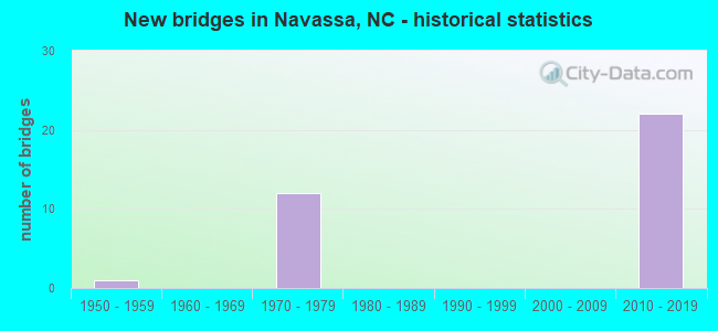
- New bridges - historical statistics
- 11950-1959
- 121970-1979
- 222010-2019


- Bridge Condition - Deck
- 47.4%Very good
- 26.3%Good
- 21.1%Satisfactory
- 5.3%Fair

- Bridge Condition - Superstructure
- 36.8%Excellent
- 31.6%Very good
- 10.5%Good
- 15.8%Satisfactory
- 5.3%Fair

- Bridge Condition - Substructure
- 31.6%Excellent
- 26.3%Very good
- 26.3%Good
- 10.5%Satisfactory
- 5.3%Fair

- Bridge Condition - Channel
- 83.3%Very good
- 16.7%Satisfactory
Find on map >> Show street view
Structure Number: 190028, Location: 0.3 MI. E. JCT. SR1486 (Lat: 34.257247, Lng: -78.037358), Route carried "on" structure: State highway 1432, Year Built: 1952, Status: Open, Structure Length: 2.13m (6.99ft), Average Daily Traffic: 1,300 (year 2019), Truck Traffic: 7%, Average Future Daily Traffic: 2,600 (year 2040), Features Intersected: MILL CREEK
Minimum Vertical Clearance: 30+ m (98+ ft), Kilometerpoint: 0.000, Lanes on structure: 2, Owner: State Highway Agency, Approaching Roadway Width: 6.7m (22.0ft), Material/Design: Steel, Design/Construction: Stringer/Multi-beam, Number Of Spans In Main Unit: 4, Length of Maximum Span: 5.1m (16.7ft), Curb or Sidewalk Widths: Left: 0.2m (0.7ft), Right: 0.2m (0.7ft), Curb-To-Curb Width: 7.3m (24.0ft), Out-to-Out Width: 8.2m (26.9ft)
Condition: Deck: Fair, Superstructure: Fair, Substructure: Fair, Channel: Satisfactory, Operating Rating: 44.4 metric tons, Method Used To Determine Operating Rating: Load Factor (LF), Inventory Rating: 26.3 metric tons, Method Used To Determine Inventory Rating: Load Factor (LF), Structural Evaluation: Somewhat better than minimum adequacy, Deck Geometry: Meets minimum limits, Waterway Adequacy: Somewhat better than minimum adequacy, Approach Roadway Alignment: Equal to present desirable criteria, Designated Inspection Frequency: Every 24 months, Underwater Inspection Frequency: Every 60 months, Inspection Date: March 2021, Underwater Inspection Date: October 2020, Deck Structure Type: Concrete Cast-file-Place, Wearing Surface/Protective System: Wearing Surface: Monolithic Concrete
Find on map >> Show street view
Structure Number: 190043, Location: 0.2 MI. W. JCT. SR1467 (Lat: 34.237978, Lng: -78.029239), Route carried "on" structure: State highway 1437, Year Built: 1973, Status: Open, Structure Length: 9.20m (30.18ft), Average Daily Traffic: 5,500 (year 2019), Truck Traffic: 7%, Average Future Daily Traffic: 11,000 (year 2040), Design Load: HS 15, Features Intersected: US74/US76
Minimum Vertical Clearance: 30+ m (98+ ft), Kilometerpoint: 0.000, Lanes on structure: 2, Lanes under structure: 5, Owner: State Highway Agency, Approaching Roadway Width: 7.3m (24.0ft), Skew: 3 degrees, Material/Design: Steel, Design/Construction: Stringer/Multi-beam, Number Of Spans In Main Unit: 4, Length of Maximum Span: 34.4m (112.9ft), Curb or Sidewalk Widths: Left: 0.1m (0.3ft), Right: 0.1m (0.3ft), Curb-To-Curb Width: 10.7m (35.1ft), Out-to-Out Width: 11.5m (37.7ft)
Condition: Deck: Satisfactory, Superstructure: Satisfactory, Substructure: Satisfactory, Operating Rating: 44.4 metric tons, Method Used To Determine Operating Rating: Load Factor (LF), Inventory Rating: 26.3 metric tons, Method Used To Determine Inventory Rating: Load Factor (LF), Structural Evaluation: Equal to present minimum criteria, Deck Geometry: Meets minimum limits, Underclear: Somewhat better than minimum adequacy, Approach Roadway Alignment: Equal to present desirable criteria, Designated Inspection Frequency: Every 24 months, Inspection Date: Febuary 2021, Deck Structure Type: Concrete Cast-file-Place, Wearing Surface/Protective System: Wearing Surface: Bituminous
Find on map >> Show street view
Structure Number: 190096, Location: 1.1 MI.S.OF JCT.NC133 (Lat: 34.226486, Lng: -78.011178), Route carried "on" structure: US 17, Year Built: 1973, Status: Open, Structure Length: 11.03m (36.19ft), Average Daily Traffic: 51,000 (year 2019), Truck Traffic: 12%, Average Future Daily Traffic: 102,000 (year 2040), Design Load: HS 20+Mod, Features Intersected: US74 & US76
Minimum Vertical Clearance: 30+ m (98+ ft), Kilometerpoint: 13.411, Lanes on structure: 5, Lanes under structure: 5, Base Highway Network: Yes (Inventory Route: 2, Subroute: 17), Owner: State Highway Agency, Approaching Roadway Width: 20.7m (67.9ft), Skew: 34 degrees, Material/Design: Steel, Design/Construction: Stringer/Multi-beam, Number Of Spans In Main Unit: 4, Length of Maximum Span: 39.6m (129.9ft), Curb-To-Curb Width: 22.3m (73.2ft), Out-to-Out Width: 23.1m (75.8ft)
Condition: Deck: Satisfactory, Superstructure: Satisfactory, Substructure: Satisfactory, Operating Rating: 81.6 metric tons, Method Used To Determine Operating Rating: Load Factor (LF), Inventory Rating: 48.9 metric tons, Method Used To Determine Inventory Rating: Load Factor (LF), Structural Evaluation: Equal to present minimum criteria, Deck Geometry: Equal to present minimum criteria, Underclear: High priority of corrective action, Approach Roadway Alignment: Equal to present desirable criteria, Designated Inspection Frequency: Every 24 months, Inspection Date: Febuary 2021, Deck Structure Type: Concrete Cast-file-Place, Wearing Surface/Protective System: Wearing Surface: Epoxy Overlay
Find on map >> Show street view
Structure Number: 190098, Location: JCT US17,74/76 (Lat: 34.232181, Lng: -77.994006), Route carried "on" structure: US 17, Year Built: 1975, Status: Open, Structure Length: 6.18m (20.28ft), Average Daily Traffic: 36,250 (year 2019), Truck Traffic: 12%, Average Future Daily Traffic: 72,500 (year 2040), Design Load: HS 20+Mod, Features Intersected: NC133,SR1472
Minimum Vertical Clearance: 30+ m (98+ ft), Kilometerpoint: 13.716, Lanes on structure: 2, Lanes under structure: 5, Base Highway Network: Yes (Inventory Route: 2, Subroute: 17), Owner: State Highway Agency, Approaching Roadway Width: 11.5m (37.7ft), Skew: 12 degrees, Material/Design: Steel, Design/Construction: Stringer/Multi-beam, Number Of Spans In Main Unit: 3, Length of Maximum Span: 41.4m (135.8ft), Curb-To-Curb Width: 12.1m (39.7ft), Out-to-Out Width: 12.8m (42.0ft)
Condition: Deck: Satisfactory, Superstructure: Good, Substructure: Good, Operating Rating: 60.7 metric tons, Method Used To Determine Operating Rating: Load Factor (LF), Inventory Rating: 36.2 metric tons, Method Used To Determine Inventory Rating: Load Factor (LF), Structural Evaluation: Better than present minimum criteria, Deck Geometry: Equal to present minimum criteria, Underclear: Somewhat better than minimum adequacy, Approach Roadway Alignment: Equal to present desirable criteria, Designated Inspection Frequency: Every 24 months, Inspection Date: Febuary 2021, Deck Structure Type: Concrete Cast-file-Place, Wearing Surface/Protective System: Wearing Surface: Monolithic Concrete
Find on map >> Show street view
Structure Number: 190099, Location: 1.1MI.N.JCT.US17/74/76 (Lat: 34.232356, Lng: -77.994258), Route carried "on" structure: US 17, Year Built: 1975, Status: Open, Structure Length: 6.30m (20.67ft), Average Daily Traffic: 72,500 (year 2019), Truck Traffic: 12%, Average Future Daily Traffic: 144,500 (year 2040), Design Load: HS 20+Mod, Features Intersected: SR1472
Minimum Vertical Clearance: 30+ m (98+ ft), Kilometerpoint: 0.000, Lanes on structure: 2, Lanes under structure: 5, Base Highway Network: Yes (Inventory Route: 2, Subroute: 17), Owner: State Highway Agency, Approaching Roadway Width: 11.5m (37.7ft), Skew: 12 degrees, Material/Design: Steel, Design/Construction: Stringer/Multi-beam, Number Of Spans In Main Unit: 3, Length of Maximum Span: 41.1m (134.8ft), Curb-To-Curb Width: 12.1m (39.7ft), Out-to-Out Width: 12.8m (42.0ft)
Condition: Deck: Satisfactory, Superstructure: Satisfactory, Substructure: Good, Operating Rating: 60.7 metric tons, Method Used To Determine Operating Rating: Load Factor (LF), Inventory Rating: 36.2 metric tons, Method Used To Determine Inventory Rating: Load Factor (LF), Structural Evaluation: Equal to present minimum criteria, Deck Geometry: Equal to present minimum criteria, Underclear: Somewhat better than minimum adequacy, Approach Roadway Alignment: Equal to present desirable criteria, Designated Inspection Frequency: Every 24 months, Inspection Date: Febuary 2021, Deck Structure Type: Concrete Cast-file-Place, Wearing Surface/Protective System: Wearing Surface: Monolithic Concrete
Find on map >> Show street view
Structure Number: 190252, Location: .3 M W JCT CEDARHILL RD (Lat: 34.273072, Lng: -78.022614), Route carried "on" structure: Business Interstate 140, Year Built: 2017, Status: Open, Structure Length: 9.93m (32.58ft), Average Daily Traffic: 5,750 (year 2018), Truck Traffic: 16%, Average Future Daily Traffic: 11,500 (year 2040), Design Load: HL 93, Features Intersected: CARTWHEEL BRANCH
Minimum Vertical Clearance: 30+ m (98+ ft), Kilometerpoint: 0.000, Lanes on structure: 2, Base Highway Network: Yes (Inventory Route: 1, Subroute: 40), Owner: State Highway Agency, Approaching Roadway Width: 13.1m (43.0ft), Skew: 3 degrees, Material/Design: Prestressed concrete continuous, Design/Construction: Stringer/Multi-beam, Number Of Spans In Main Unit: 4, Length of Maximum Span: 26.8m (87.9ft), Curb-To-Curb Width: 12.8m (42.0ft), Out-to-Out Width: 13.7m (44.9ft)
Condition: Deck: Very good, Superstructure: Very good, Substructure: Very good, Channel: Very good, Operating Rating: 63.5 metric tons, Method Used To Determine Operating Rating: Load and Resistance Factor (LRFR), Inventory Rating: 48.9 metric tons, Method Used To Determine Inventory Rating: Load and Resistance Factor (LRFR), Structural Evaluation: Equal to present desirable criteria, Deck Geometry: Equal to present desirable criteria, Waterway Adequacy: Equal to present desirable criteria, Approach Roadway Alignment: Equal to present desirable criteria, Designated Inspection Frequency: Every 24 months, Inspection Date: April 2020, Deck Structure Type: Concrete Cast-file-Place, Wearing Surface/Protective System: Wearing Surface: Monolithic Concrete, Deck Protection: Epoxy Coated Reinforcing
Find on map >> Show street view
Structure Number: 190253, Location: 1.87 MI NORTH OF SR1426 (Lat: 34.272900, Lng: -78.017225), Route carried "on" structure: Interstate 140, Year Built: 2017, Status: Open, Structure Length: 4.41m (14.47ft), Average Daily Traffic: 13,500 (year 2018), Truck Traffic: 16%, Average Future Daily Traffic: 27,000 (year 2040), Design Load: HL 93, Features Intersected: SR1430
Minimum Vertical Clearance: 30+ m (98+ ft), Kilometerpoint: 3.169, Lanes on structure: 2, Lanes under structure: 3, Base Highway Network: Yes (Inventory Route: 1, Subroute: 40), Owner: State Highway Agency, Approaching Roadway Width: 12.8m (42.0ft), Skew: 2 degrees, Material/Design: Steel, Design/Construction: Stringer/Multi-beam, Number Of Spans In Main Unit: 1, Length of Maximum Span: 43.2m (141.7ft), Curb-To-Curb Width: 12.7m (41.7ft), Out-to-Out Width: 13.7m (44.9ft)
Condition: Deck: Good, Superstructure: Very good, Substructure: Excellent, Operating Rating: 68.0 metric tons, Method Used To Determine Operating Rating: Load and Resistance Factor (LRFR), Inventory Rating: 52.6 metric tons, Method Used To Determine Inventory Rating: Load and Resistance Factor (LRFR), Structural Evaluation: Equal to present desirable criteria, Deck Geometry: Better than present minimum criteria, Underclear: Superior to present desirable criteria, Approach Roadway Alignment: Equal to present desirable criteria, Designated Inspection Frequency: Every 24 months, Inspection Date: April 2020, Deck Structure Type: Concrete Cast-file-Place, Wearing Surface/Protective System: Wearing Surface: Monolithic Concrete
Find on map >> Show street view
Structure Number: 190254, Location: 1.87 MI N JCT SR1426 (Lat: 34.273119, Lng: -78.017333), Route carried "on" structure: Interstate 140, Year Built: 2017, Status: Open, Structure Length: 4.41m (14.47ft), Average Daily Traffic: 10,000 (year 2017), Truck Traffic: 16%, Average Future Daily Traffic: 20,000 (year 2040), Design Load: HL 93, Features Intersected: SR1430
Minimum Vertical Clearance: 30+ m (98+ ft), Kilometerpoint: 3.169, Lanes on structure: 3, Lanes under structure: 2, Base Highway Network: Yes (Inventory Route: 1, Subroute: 40), Owner: State Highway Agency, Approaching Roadway Width: 14.9m (48.9ft), Skew: 12 degrees, Material/Design: Steel, Design/Construction: Stringer/Multi-beam, Number Of Spans In Main Unit: 1, Number Of Approach Spans: 2, Length of Maximum Span: 43.2m (141.7ft), Curb-To-Curb Width: 14.4m (47.2ft), Out-to-Out Width: 15.6m (51.2ft)
Condition: Deck: Good, Superstructure: Excellent, Substructure: Good, Operating Rating: 66.2 metric tons, Method Used To Determine Operating Rating: Load and Resistance Factor (LRFR), Inventory Rating: 50.8 metric tons, Method Used To Determine Inventory Rating: Load and Resistance Factor (LRFR), Structural Evaluation: Better than present minimum criteria, Deck Geometry: Meets minimum limits, Underclear: Better than present minimum criteria, Approach Roadway Alignment: Equal to present desirable criteria, Designated Inspection Frequency: Every 24 months, Inspection Date: April 2020, Deck Structure Type: Concrete Cast-file-Place, Wearing Surface/Protective System: Wearing Surface: Monolithic Concrete, Deck Protection: Epoxy Coated Reinforcing
Find on map >> Show street view
Structure Number: 190255, Location: 0.3 MI S JCT SR1455 (Lat: 34.275278, Lng: -78.348611), Route carried "on" structure: State highway 1426, Year Built: 2017, Status: Open, Structure Length: 6.40m (21.00ft), Average Daily Traffic: 9,500 (year 2019), Truck Traffic: 6%, Average Future Daily Traffic: 19,000 (year 2040), Design Load: HL 93, Features Intersected: I-140
Minimum Vertical Clearance: 30+ m (98+ ft), Kilometerpoint: 0.000, Lanes on structure: 3, Lanes under structure: 5, Owner: State Highway Agency, Approaching Roadway Width: 15.5m (50.9ft), Skew: 21 degrees, Material/Design: Prestressed concrete continuous, Design/Construction: Stringer/Multi-beam, Number Of Spans In Main Unit: 2, Number Of Approach Spans: 2, Length of Maximum Span: 32.0m (105.0ft), Curb-To-Curb Width: 15.6m (51.2ft), Out-to-Out Width: 16.8m (55.1ft)
Condition: Deck: Very good, Superstructure: Very good, Substructure: Very good, Operating Rating: 61.6 metric tons, Method Used To Determine Operating Rating: Load and Resistance Factor (LRFR), Inventory Rating: 46.2 metric tons, Method Used To Determine Inventory Rating: Load and Resistance Factor (LRFR), Structural Evaluation: Equal to present desirable criteria, Deck Geometry: Equal to present minimum criteria, Underclear: Somewhat better than minimum adequacy, Approach Roadway Alignment: Equal to present desirable criteria, Designated Inspection Frequency: Every 24 months, Inspection Date: July 2021, Deck Structure Type: Concrete Cast-file-Place, Wearing Surface/Protective System: Wearing Surface: Monolithic Concrete, Deck Protection: Epoxy Coated Reinforcing
Find on map >> Show street view
Structure Number: 190256, Location: 0.3 MI N JCT SR1455 (Lat: 34.275667, Lng: -78.048917), Route carried "on" structure: State highway 1426, Year Built: 2017, Status: Open, Structure Length: 2.98m (9.78ft), Average Daily Traffic: 9,500 (year 2019), Truck Traffic: 6%, Average Future Daily Traffic: 19,000 (year 2040), Design Load: H 10, Features Intersected: CSX RR
Minimum Vertical Clearance: 30+ m (98+ ft), Kilometerpoint: 0.000, Lanes on structure: 2, Owner: State Highway Agency, Approaching Roadway Width: 19.2m (63.0ft), Skew: 2 degrees, Material/Design: Prestressed concrete continuous, Design/Construction: Stringer/Multi-beam, Number Of Spans In Main Unit: 1, Number Of Approach Spans: 2, Length of Maximum Span: 28.6m (93.8ft), Curb-To-Curb Width: 19.2m (63.0ft), Out-to-Out Width: 20.4m (66.9ft)
Condition: Deck: Very good, Superstructure: Very good, Substructure: Very good, Operating Rating: 61.6 metric tons, Method Used To Determine Operating Rating: Load and Resistance Factor (LRFR), Inventory Rating: 47.1 metric tons, Method Used To Determine Inventory Rating: Load and Resistance Factor (LRFR), Structural Evaluation: Equal to present desirable criteria, Deck Geometry: Superior to present desirable criteria, Underclear: Superior to present desirable criteria, Approach Roadway Alignment: Equal to present desirable criteria, Designated Inspection Frequency: Every 24 months, Inspection Date: July 2021, Deck Structure Type: Concrete Cast-file-Place, Wearing Surface/Protective System: Wearing Surface: Monolithic Concrete, Deck Protection: Epoxy Coated Reinforcing
Find on map >> Show street view
Structure Number: 190257, Location: 0.1 MI. S. JCT. SR1431 (Lat: 34.268133, Lng: -78.015064), Route carried "on" structure: State highway 1430, Year Built: 2017, Status: Open, Structure Length: 9.99m (32.78ft), Average Daily Traffic: 2,800 (year 2015), Truck Traffic: 7%, Average Future Daily Traffic: 5,600 (year 2040), Design Load: HL 93, Features Intersected: CARTWHEEL BRANCH
Minimum Vertical Clearance: 30+ m (98+ ft), Kilometerpoint: 0.000, Lanes on structure: 2, Owner: State Highway Agency, Approaching Roadway Width: 10.0m (32.8ft), Skew: 9 degrees, Material/Design: Prestressed concrete, Design/Construction: Stringer/Multi-beam, Number Of Spans In Main Unit: 4, Length of Maximum Span: 24.3m (79.7ft), Curb-To-Curb Width: 16.9m (55.4ft), Out-to-Out Width: 18.0m (59.1ft)
Condition: Deck: Very good, Superstructure: Excellent, Substructure: Very good, Channel: Very good, Operating Rating: 89.8 metric tons, Method Used To Determine Operating Rating: Load and Resistance Factor (LRFR), Inventory Rating: 45.3 metric tons, Method Used To Determine Inventory Rating: Load and Resistance Factor (LRFR), Structural Evaluation: Equal to present desirable criteria, Deck Geometry: Superior to present desirable criteria, Waterway Adequacy: Better than present minimum criteria, Approach Roadway Alignment: Equal to present desirable criteria, Designated Inspection Frequency: Every 24 months, Inspection Date: April 2020, Deck Structure Type: Concrete Cast-file-Place, Wearing Surface/Protective System: Wearing Surface: Monolithic Concrete
Find on map >> Show street view
Structure Number: 1290189, Location: 1.25 MI E. JCT CEDAR HILL (Lat: 36.273117, Lng: -77.995689), Route carried "on" structure: Interstate 140, Year Built: 2017, Status: Open, Structure Length: 219.36m (719.69ft), Average Daily Traffic: 11,750 (year 2019), Truck Traffic: 16%, Average Future Daily Traffic: 23,500 (year 2040), Design Load: HL 93, Features Intersected: CAPE FEAR RIVER
Minimum Vertical Clearance: 30+ m (98+ ft), Kilometerpoint: 3.352, Lanes on structure: 2, Base Highway Network: Yes (Inventory Route: 10, Subroute: 40), Owner: State Highway Agency, Approaching Roadway Width: 13.1m (43.0ft), Skew: 10 degrees, Material/Design: Prestressed concrete, Design/Construction: Stringer/Multi-beam, Number Of Spans In Main Unit: 58, Length of Maximum Span: 35.9m (117.8ft), Curb-To-Curb Width: 12.8m (42.0ft), Out-to-Out Width: 13.4m (44.0ft)
Condition: Deck: Good, Superstructure: Good, Substructure: Good, Channel: Very good, Operating Rating: 73.4 metric tons, Method Used To Determine Operating Rating: Load and Resistance Factor (LRFR), Inventory Rating: 47.1 metric tons, Method Used To Determine Inventory Rating: Load and Resistance Factor (LRFR), Structural Evaluation: Better than present minimum criteria, Deck Geometry: Equal to present desirable criteria, Waterway Adequacy: Equal to present desirable criteria, Approach Roadway Alignment: Equal to present desirable criteria, Designated Inspection Frequency: Every 24 months, Inspection Date: April 2020, Deck Structure Type: Concrete Cast-file-Place
Find on map >> Show street view
Structure Number: 129019, Location: 1.25 MI. N.JCT CEDAR HILL (Lat: 36.273333, Lng: -77.995694), Route carried "on" structure: Interstate 140, Year Built: 2017, Status: Open, Structure Length: 218.60m (717.19ft), Average Daily Traffic: 13,500 (year 2018), Truck Traffic: 16%, Average Future Daily Traffic: 27,000 (year 2040), Design Load: HL 93, Features Intersected: CAPE FEAR RIVER, Facility Carried by Structure: I40W,US17S
Minimum Vertical Clearance: 30+ m (98+ ft), Kilometerpoint: 3.352, Lanes on structure: 2, Base Highway Network: Yes (Inventory Route: 1, Subroute: 40), Owner: State Highway Agency, Approaching Roadway Width: 12.8m (42.0ft), Skew: 10 degrees, Material/Design: Prestressed concrete, Design/Construction: Stringer/Multi-beam, Number Of Spans In Main Unit: 58, Length of Maximum Span: 85.3m (279.9ft), Curb-To-Curb Width: 12.6m (41.3ft), Out-to-Out Width: 13.4m (44.0ft)
Condition: Deck: Very good, Superstructure: Very good, Substructure: Good, Channel: Very good, Operating Rating: 73.4 metric tons, Method Used To Determine Operating Rating: Load and Resistance Factor (LRFR), Inventory Rating: 48.9 metric tons, Method Used To Determine Inventory Rating: Load and Resistance Factor (LRFR), Structural Evaluation: Better than present minimum criteria, Deck Geometry: Better than present minimum criteria, Waterway Adequacy: Equal to present desirable criteria, Approach Roadway Alignment: Equal to present desirable criteria, Designated Inspection Frequency: Every 24 months, Underwater Inspection Frequency: Every 60 months, Inspection Date: April 2020, Underwater Inspection Date: April 2019, Deck Structure Type: Concrete Cast-file-Place, Wearing Surface/Protective System: Wearing Surface: Monolithic Concrete, Deck Protection: Epoxy Coated Reinforcing
Find on map >> Show street view
Structure Number: 1290191, Location: 1.0 MI.S. JCT. US421 (Lat: 34.278275, Lng: -77.979825), Route carried "on" structure: Interstate 140, Year Built: 2017, Status: Open, Structure Length: 6.00m (19.69ft), Average Daily Traffic: 10,000 (year 2017), Truck Traffic: 16%, Average Future Daily Traffic: 20,000 (year 2040), Design Load: HL 93, Features Intersected: PROGRESS ENERGY SPUR LIN
Minimum Vertical Clearance: 30+ m (98+ ft), Kilometerpoint: 3.810, Lanes on structure: 2, Base Highway Network: Yes (Inventory Route: 1, Subroute: 40), Owner: State Highway Agency, Approaching Roadway Width: 12.8m (42.0ft), Skew: 2 degrees, Material/Design: Prestressed concrete, Design/Construction: Stringer/Multi-beam, Number Of Spans In Main Unit: 3, Length of Maximum Span: 37.7m (123.7ft), Curb-To-Curb Width: 12.6m (41.3ft), Out-to-Out Width: 13.7m (44.9ft)
Condition: Deck: Very good, Superstructure: Excellent, Substructure: Excellent, Operating Rating: 71.6 metric tons, Method Used To Determine Operating Rating: Load and Resistance Factor (LRFR), Inventory Rating: 51.7 metric tons, Method Used To Determine Inventory Rating: Load and Resistance Factor (LRFR), Structural Evaluation: Superior to present desirable criteria, Deck Geometry: Better than present minimum criteria, Underclear: Better than present minimum criteria, Approach Roadway Alignment: Equal to present desirable criteria, Designated Inspection Frequency: Every 24 months, Inspection Date: April 2020, Deck Structure Type: Concrete Cast-file-Place, Wearing Surface/Protective System: Wearing Surface: Monolithic Concrete, Deck Protection: Epoxy Coated Reinforcing
Find on map >> Show street view
Structure Number: 1290192, Location: 1.0 MI. W. JCT. US421 (Lat: 34.278494, Lng: -77.979911), Route carried "on" structure: Interstate 140, Year Built: 2017, Status: Open, Structure Length: 6.03m (19.78ft), Average Daily Traffic: 13,500 (year 2018), Truck Traffic: 16%, Average Future Daily Traffic: 27,000 (year 2040), Design Load: HL 93, Features Intersected: PROG.ENERGY SPUR RR
Minimum Vertical Clearance: 30+ m (98+ ft), Kilometerpoint: 3.810, Lanes on structure: 2, Base Highway Network: Yes (Inventory Route: 1, Subroute: 40), Owner: State Highway Agency, Approaching Roadway Width: 12.8m (42.0ft), Skew: 2 degrees, Material/Design: Prestressed concrete, Design/Construction: Stringer/Multi-beam, Number Of Spans In Main Unit: 3, Number Of Approach Spans: 2, Length of Maximum Span: 37.7m (123.7ft), Curb-To-Curb Width: 12.6m (41.3ft), Out-to-Out Width: 13.7m (44.9ft)
Condition: Deck: Very good, Superstructure: Excellent, Substructure: Excellent, Operating Rating: 71.6 metric tons, Method Used To Determine Operating Rating: Load and Resistance Factor (LRFR), Inventory Rating: 51.7 metric tons, Method Used To Determine Inventory Rating: Load and Resistance Factor (LRFR), Structural Evaluation: Superior to present desirable criteria, Deck Geometry: Better than present minimum criteria, Underclear: Equal to present minimum criteria, Approach Roadway Alignment: Equal to present desirable criteria, Designated Inspection Frequency: Every 24 months, Inspection Date: April 2020, Deck Structure Type: Concrete Cast-file-Place, Wearing Surface/Protective System: Wearing Surface: Monolithic Concrete
Find on map >> Show street view
Structure Number: 1290193, Location: 0.5 MI. W. JCT. US421 (Lat: 34.283542, Lng: -77.973583), Route carried "on" structure: Interstate 140, Year Built: 2017, Status: Open, Structure Length: 7.46m (24.48ft), Average Daily Traffic: 13,500 (year 2018), Truck Traffic: 16%, Average Future Daily Traffic: 27,000 (year 2040), Design Load: HL 93, Features Intersected: SR1394, PROG ENER. RR
Minimum Vertical Clearance: 30+ m (98+ ft), Kilometerpoint: 3.962, Lanes on structure: 2, Lanes under structure: 2, Base Highway Network: Yes (Inventory Route: 1, Subroute: 40), Owner: State Highway Agency, Approaching Roadway Width: 16.4m (53.8ft), Skew: 3 degrees, Material/Design: Prestressed concrete continuous, Design/Construction: Stringer/Multi-beam, Number Of Spans In Main Unit: 3, Number Of Approach Spans: 2, Length of Maximum Span: 30.1m (98.8ft), Curb-To-Curb Width: 12.6m (41.3ft), Out-to-Out Width: 13.7m (44.9ft)
Condition: Deck: Very good, Superstructure: Excellent, Substructure: Excellent, Operating Rating: 82.5 metric tons, Method Used To Determine Operating Rating: Load and Resistance Factor (LRFR), Inventory Rating: 45.3 metric tons, Method Used To Determine Inventory Rating: Load and Resistance Factor (LRFR), Structural Evaluation: Superior to present desirable criteria, Deck Geometry: Better than present minimum criteria, Underclear: Better than present minimum criteria, Approach Roadway Alignment: Equal to present desirable criteria, Designated Inspection Frequency: Every 24 months, Inspection Date: April 2020, Deck Structure Type: Concrete Cast-file-Place, Wearing Surface/Protective System: Wearing Surface: Monolithic Concrete
Find on map >> Show street view
Structure Number: 1290194, Location: 0.5 MI. E. JCT. US421 (Lat: 34.283603, Lng: -77.973956), Route carried "on" structure: Interstate 140, Year Built: 2017, Status: Open, Structure Length: 7.46m (24.48ft), Average Daily Traffic: 13,500 (year 2018), Truck Traffic: 16%, Average Future Daily Traffic: 27,000 (year 2040), Design Load: HL 93, Features Intersected: SR1394, PR ENGY SPUR RR
Minimum Vertical Clearance: 30+ m (98+ ft), Kilometerpoint: 3.962, Lanes on structure: 3, Lanes under structure: 2, Base Highway Network: Yes (Inventory Route: 1, Subroute: 40), Owner: State Highway Agency, Approaching Roadway Width: 14.9m (48.9ft), Skew: 3 degrees, Material/Design: Prestressed concrete continuous, Design/Construction: Stringer/Multi-beam, Number Of Spans In Main Unit: 3, Number Of Approach Spans: 2, Length of Maximum Span: 30.1m (98.8ft), Curb-To-Curb Width: 14.4m (47.2ft), Out-to-Out Width: 15.6m (51.2ft)
Condition: Deck: Very good, Superstructure: Excellent, Substructure: Excellent, Operating Rating: 79.8 metric tons, Method Used To Determine Operating Rating: Load and Resistance Factor (LRFR), Inventory Rating: 45.3 metric tons, Method Used To Determine Inventory Rating: Load and Resistance Factor (LRFR), Structural Evaluation: Superior to present desirable criteria, Deck Geometry: Meets minimum limits, Underclear: Equal to present minimum criteria, Approach Roadway Alignment: Equal to present desirable criteria, Designated Inspection Frequency: Every 24 months, Inspection Date: April 2020, Deck Structure Type: Concrete Cast-file-Place, Wearing Surface/Protective System: Wearing Surface: Monolithic Concrete, Deck Protection: Epoxy Coated Reinforcing
Find on map >> Show street view
Structure Number: 1290196, Location: 0.2 MILES SOUTH OF US421 (Lat: 34.286969, Lng: -77.970758), Route carried "on" structure: Interstate 140, Year Built: 2017, Status: Open, Structure Length: 2.86m (9.38ft), Average Daily Traffic: 9,000 (year 2015), Truck Traffic: 16%, Average Future Daily Traffic: 18,000 (year 2040), Design Load: HL 93, Features Intersected: CSX SEA. COAST RR
Minimum Vertical Clearance: 30+ m (98+ ft), Kilometerpoint: 4.053, Lanes on structure: 2, Base Highway Network: Yes (Inventory Route: 1, Subroute: 40), Owner: State Highway Agency, Approaching Roadway Width: 12.8m (42.0ft), Skew: 2 degrees, Material/Design: Prestressed concrete, Design/Construction: Stringer/Multi-beam, Number Of Spans In Main Unit: 1, Number Of Approach Spans: 2, Length of Maximum Span: 27.4m (89.9ft), Curb-To-Curb Width: 12.6m (41.3ft), Out-to-Out Width: 13.7m (44.9ft)
Condition: Deck: Good, Superstructure: Excellent, Substructure: Excellent, Operating Rating: 76.2 metric tons, Method Used To Determine Operating Rating: Load and Resistance Factor (LRFR), Inventory Rating: 47.1 metric tons, Method Used To Determine Inventory Rating: Load and Resistance Factor (LRFR), Structural Evaluation: Superior to present desirable criteria, Deck Geometry: Better than present minimum criteria, Underclear: High priority of corrective action, Approach Roadway Alignment: Equal to present desirable criteria, Designated Inspection Frequency: Every 24 months, Inspection Date: March 2020, Deck Structure Type: Concrete Cast-file-Place, Wearing Surface/Protective System: Wearing Surface: Monolithic Concrete
Find on map >> Show street view
Structure Number: 1290217, Location: 2.9 MI. N. JCT. SR 2115 (Lat: 34.331228, Lng: -77.999744), Route carried "on" structure: US 421, Year Built: 2019, Status: Open, Structure Length: 17.12m (56.17ft), Average Daily Traffic: 5,000 (year 2019), Truck Traffic: 14%, Average Future Daily Traffic: 10,000 (year 2040), Design Load: HL 93, Features Intersected: FISHING CREEK
Minimum Vertical Clearance: 30+ m (98+ ft), Kilometerpoint: 0.000, Lanes on structure: 2, Base Highway Network: Yes, Owner: State Highway Agency, Approaching Roadway Width: 10.3m (33.8ft), Material/Design: Prestressed concrete, Design/Construction: Slab, Number Of Spans In Main Unit: 5, Length of Maximum Span: 23.7m (77.8ft), Curb-To-Curb Width: 10.3m (33.8ft), Out-to-Out Width: 11.3m (37.1ft)
Condition: Deck: Good, Superstructure: Very good, Substructure: Very good, Channel: Very good, Operating Rating: 64.4 metric tons, Method Used To Determine Operating Rating: Load and Resistance Factor (LRFR), Inventory Rating: 48.9 metric tons, Method Used To Determine Inventory Rating: Load and Resistance Factor (LRFR), Structural Evaluation: Equal to present desirable criteria, Deck Geometry: Meets minimum limits, Waterway Adequacy: Equal to present desirable criteria, Approach Roadway Alignment: Equal to present desirable criteria, Designated Inspection Frequency: Every 24 months, Underwater Inspection Frequency: Every 60 months, Inspection Date: December 2021, Underwater Inspection Date: January 2020, Deck Structure Type: Concrete Cast-file-Place, Wearing Surface/Protective System: Wearing Surface: Monolithic Concrete, Deck Protection: Epoxy Coated Reinforcing
Find on map >> Show street view
Structure Number: 190043, Location: 0.2 MI. W. JCT. SR1467 (Lat: 34.237978, Lng: -78.029239), Route carried "under" structure: US 74, Year Built: 1973, Structure Length: 0. m, Average Daily Traffic: 13,750 (year 2019), Truck Traffic: 12%, Features Intersected: SR1437
Minimum Vertical Clearance: 5.09m (16.70ft), Kilometerpoint: 0.000, Lanes on structure: 2, Lanes under structure: 2, Material/Design: Steel, Design/Construction: Stringer/Multi-beam, Length of Maximum Span: 34.4m (112.9ft)
Find on map >> Show street view
Structure Number: 190043, Location: 0.2 MI. W. JCT. SR1467 (Lat: 34.237978, Lng: -78.029239), Route carried "under" structure: US 74, Year Built: 1973, Structure Length: 0. m, Average Daily Traffic: 13,750 (year 2019), Truck Traffic: 12%, Features Intersected: SR1437
Minimum Vertical Clearance: 5.02m (16.47ft), Kilometerpoint: 0.000, Lanes on structure: 2, Lanes under structure: 3, Material/Design: Steel, Design/Construction: Stringer/Multi-beam, Length of Maximum Span: 34.4m (112.9ft)
Find on map >> Show street view
Structure Number: 190096, Location: 1.1 MI.S.OF JCT.NC133 (Lat: 34.226486, Lng: -78.011178), Route carried "under" structure: US 74, Year Built: 1973, Structure Length: 0. m, Average Daily Traffic: 13,750 (year 2019), Truck Traffic: 12%, Features Intersected: US17
Minimum Vertical Clearance: 5.66m (18.57ft), Kilometerpoint: 0.000, Lanes on structure: 5, Lanes under structure: 3, Material/Design: Steel, Design/Construction: Stringer/Multi-beam, Length of Maximum Span: 39.6m (129.9ft)
Find on map >> Show street view
Structure Number: 190096, Location: 1.1 MI.S.OF JCT.NC133 (Lat: 34.226486, Lng: -78.011178), Route carried "under" structure: US 74, Year Built: 1973, Structure Length: 0. m, Average Daily Traffic: 13,750 (year 2019), Truck Traffic: 12%, Features Intersected: US17
Minimum Vertical Clearance: 5.36m (17.59ft), Kilometerpoint: 0.000, Lanes on structure: 5, Lanes under structure: 2, Material/Design: Steel, Design/Construction: Stringer/Multi-beam, Length of Maximum Span: 39.6m (129.9ft)
Find on map >> Show street view
Structure Number: 190098, Location: JCT US17,74/76 (Lat: 34.232181, Lng: -77.994006), Route carried "under" structure: State highway 133, Year Built: 1975, Structure Length: 0. m, Average Daily Traffic: 23,000 (year 2019), Truck Traffic: 6%, Features Intersected: US17,US74,US76
Minimum Vertical Clearance: 4.77m (15.65ft), Kilometerpoint: 0.000, Lanes on structure: 2, Lanes under structure: 3, Material/Design: Steel, Design/Construction: Stringer/Multi-beam, Length of Maximum Span: 41.4m (135.8ft)
Find on map >> Show street view
Structure Number: 190098, Location: JCT US17,74/76 (Lat: 34.232181, Lng: -77.994006), Route carried "under" structure: State highway 133, Year Built: 1975, Structure Length: 0. m, Average Daily Traffic: 23,000 (year 2019), Truck Traffic: 6%, Features Intersected: US17,US74,US76
Minimum Vertical Clearance: 4.72m (15.49ft), Kilometerpoint: 0.000, Lanes on structure: 2, Lanes under structure: 2, Material/Design: Steel, Design/Construction: Stringer/Multi-beam, Length of Maximum Span: 41.4m (135.8ft)
Find on map >> Show street view
Structure Number: 190099, Location: 1.1MI.N.JCT.US17/74/76 (Lat: 34.232356, Lng: -77.994258), Route carried "under" structure: State highway 1472, Year Built: 1975, Structure Length: 0. m, Average Daily Traffic: 14,500 (year 2019), Truck Traffic: 12%, Features Intersected: US17/US74/76
Minimum Vertical Clearance: 4.97m (16.31ft), Kilometerpoint: 0.000, Lanes on structure: 2, Lanes under structure: 2, Material/Design: Steel, Design/Construction: Stringer/Multi-beam, Length of Maximum Span: 41.1m (134.8ft)
Find on map >> Show street view
Structure Number: 190099, Location: 1.1MI.N.JCT.US17/74/76 (Lat: 34.232356, Lng: -77.994258), Route carried "under" structure: State highway 1472, Year Built: 1975, Structure Length: 0. m, Average Daily Traffic: 14,500 (year 2019), Truck Traffic: 12%, Features Intersected: US17/US74/76
Minimum Vertical Clearance: 5.09m (16.70ft), Kilometerpoint: 0.000, Lanes on structure: 2, Lanes under structure: 3, Material/Design: Steel, Design/Construction: Stringer/Multi-beam, Length of Maximum Span: 41.1m (134.8ft)
Find on map >> Show street view
Structure Number: 190253, Location: 1.87 MI NORTH OF SR1426 (Lat: 34.272900, Lng: -78.017225), Route carried "under" structure: State highway 1430, Year Built: 2017, Structure Length: 0. m, Average Daily Traffic: 2,800 (year 2015), Truck Traffic: 7%, Features Intersected: I-140E, US17N
Minimum Vertical Clearance: 5.71m (18.73ft), Kilometerpoint: 0.000, Lanes on structure: 2, Lanes under structure: 2, Material/Design: Steel, Design/Construction: Stringer/Multi-beam, Length of Maximum Span: 43.2m (141.7ft)
Find on map >> Show street view
Structure Number: 190253, Location: 1.87 MI NORTH OF SR1426 (Lat: 34.272900, Lng: -78.017225), Route carried "under" structure: State highway 1430, Year Built: 2017, Structure Length: 0. m, Average Daily Traffic: 2,800 (year 2015), Truck Traffic: 7%, Features Intersected: I-140E, US17N
Minimum Vertical Clearance: 5.10m (16.73ft), Kilometerpoint: 0.000, Lanes on structure: 2, Lanes under structure: 1, Material/Design: Steel, Design/Construction: Stringer/Multi-beam, Length of Maximum Span: 43.2m (141.7ft)
Find on map >> Show street view
Structure Number: 190254, Location: 1.87 MI N JCT SR1426 (Lat: 34.273119, Lng: -78.017333), Route carried "under" structure: State highway 143, Year Built: 2017, Structure Length: 0. m, Average Daily Traffic: 2,800 (year 2015), Truck Traffic: 7%, Features Intersected: I140W,US17S
Minimum Vertical Clearance: 5.89m (19.32ft), Kilometerpoint: 0.000, Lanes on structure: 3, Lanes under structure: 1, Material/Design: Steel, Design/Construction: Stringer/Multi-beam, Length of Maximum Span: 43.2m (141.7ft)
Find on map >> Show street view
Structure Number: 190254, Location: 1.87 MI N JCT SR1426 (Lat: 34.273119, Lng: -78.017333), Route carried "under" structure: State highway 1430, Year Built: 2017, Structure Length: 0. m, Average Daily Traffic: 2,800 (year 2015), Truck Traffic: 7%, Features Intersected: I140W,US17S
Minimum Vertical Clearance: 5.05m (16.57ft), Kilometerpoint: 0.000, Lanes on structure: 3, Lanes under structure: 1, Material/Design: Steel, Design/Construction: Stringer/Multi-beam, Length of Maximum Span: 43.2m (141.7ft)
Find on map >> Show street view
Structure Number: 190255, Location: 0.3 MI S JCT SR1455 (Lat: 34.275278, Lng: -78.348611), Route carried "under" structure: Interstate 140, Year Built: 2017, Structure Length: 0. m, Average Daily Traffic: 11,750 (year 2019), Truck Traffic: 16%, Features Intersected: SR1426
Minimum Vertical Clearance: 5.71m (18.73ft), Kilometerpoint: 2.590, Lanes on structure: 3, Lanes under structure: 3, Material/Design: Prestressed concrete continuous, Design/Construction: Stringer/Multi-beam, Length of Maximum Span: 32.0m (105.0ft)
Find on map >> Show street view
Structure Number: 190255, Location: 0.3 MI S JCT SR1455 (Lat: 34.275278, Lng: -78.348611), Route carried "under" structure: Interstate 140, Year Built: 2017, Structure Length: 0. m, Average Daily Traffic: 11,750 (year 2019), Truck Traffic: 16%, Features Intersected: SR1426
Minimum Vertical Clearance: 6.12m (20.08ft), Kilometerpoint: 2.590, Lanes on structure: 3, Lanes under structure: 2, Material/Design: Prestressed concrete continuous, Design/Construction: Stringer/Multi-beam, Length of Maximum Span: 32.0m (105.0ft)
Find on map >> Show street view
Structure Number: 1290193, Location: 0.5 MI. W. JCT. US421 (Lat: 34.283542, Lng: -77.973583), Route carried "under" structure: State highway 1394, Year Built: 2017, Structure Length: 0. m, Average Daily Traffic: 100 (year 2015), Truck Traffic: 7%, Features Intersected: I-140E,US17N
Minimum Vertical Clearance: 5.99m (19.65ft), Kilometerpoint: 0.000, Lanes on structure: 2, Lanes under structure: 2, Material/Design: Prestressed concrete continuous, Design/Construction: Stringer/Multi-beam, Length of Maximum Span: 30.1m (98.8ft)
Find on map >> Show street view
Structure Number: 1290194, Location: 0.5 MI. E. JCT. US421 (Lat: 34.283603, Lng: -77.973956), Route carried "under" structure: State highway 1394, Year Built: 2017, Structure Length: 0. m, Average Daily Traffic: 100 (year 2015), Truck Traffic: 7%, Features Intersected: I140W,US17S
Minimum Vertical Clearance: 5.28m (17.32ft), Kilometerpoint: 0.000, Lanes on structure: 3, Lanes under structure: 2, Material/Design: Prestressed concrete continuous, Design/Construction: Stringer/Multi-beam, Length of Maximum Span: 30.1m (98.8ft)