Bridge Statistics for Nederland, Texas (TX)
Condition, Traffic, Stress, Structural Evaluation, Project Costs
- National Bridge Inventory (NBI) Statistics
- 24Number of bridges
- 374ft / 114mTotal length
- $118,000Total costs
- 197,382Total average daily traffic
- 7,294Total average daily truck traffic
- National Bridge Inventory (NBI) Registered Bridges for Nederland
- No street view available for this location
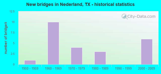
- New bridges - historical statistics
- 11950-1959
- 101960-1969
- 41970-1979
- 31980-1989
- 62000-2009
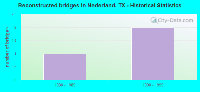
- Reconstructed bridges - Historical Statistics
- 11980-1989
- 21990-1999
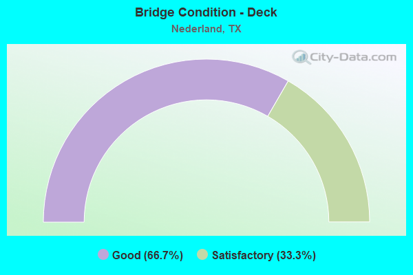
- Bridge Condition - Deck
- 66.7%Good
- 33.3%Satisfactory

- Bridge Condition - Superstructure
- 50.0%Good
- 33.3%Satisfactory
- 16.7%Fair
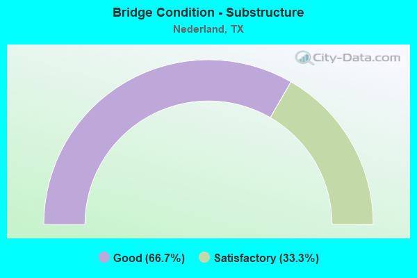
- Bridge Condition - Substructure
- 66.7%Good
- 33.3%Satisfactory
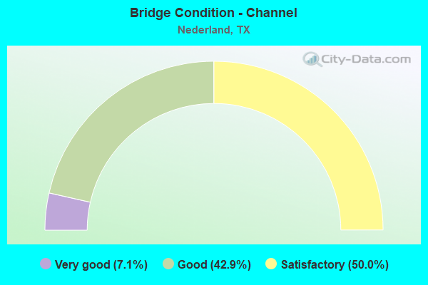
- Bridge Condition - Channel
- 7.1%Very good
- 42.9%Good
- 50.0%Satisfactory
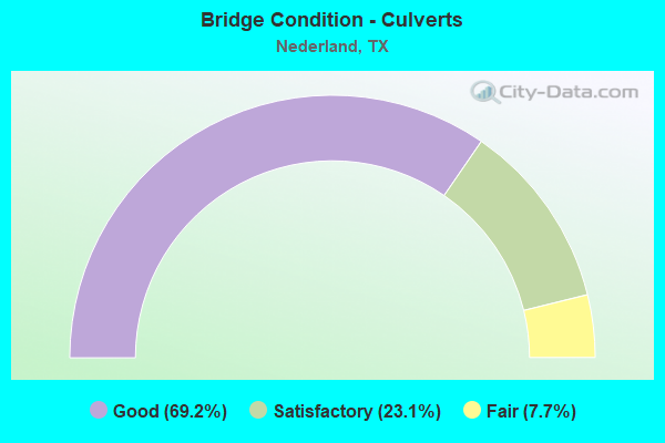
- Bridge Condition - Culverts
- 69.2%Good
- 23.1%Satisfactory
- 7.7%Fair
Find on map >> Show street view
Structure Number: 201240020015135, Location: 1.80 MI NW OF FM 365 (Lat: 29.963350, Lng: -94.016272), Route carried "on" structure: US 69, Year Built: 1978, Status: Open, Structure Length: 7.07m (23.20ft), Average Daily Traffic: 21,130 (year 2013), Truck Traffic: 8%, Average Future Daily Traffic: 29,580 (year 2033), Design Load: HS 20, Features Intersected: JERRY WARE DR
Minimum Vertical Clearance: 30+ m (98+ ft), Kilometerpoint: 19.956, Lanes on structure: 2, Lanes under structure: 4, Owner: State Highway Agency, Approaching Roadway Width: 11.6m (38.1ft), Material/Design: Prestressed concrete, Design/Construction: Stringer/Multi-beam, Number Of Spans In Main Unit: 2, Number Of Approach Spans: 2, Length of Maximum Span: 21.3m (69.9ft), Curb-To-Curb Width: 11.8m (38.7ft), Out-to-Out Width: 12.3m (40.4ft)
Condition: Deck: Satisfactory, Superstructure: Satisfactory, Substructure: Good, Operating Rating: 54.4 metric tons, Method Used To Determine Operating Rating: Assigned rating based on Load Factor Design (LFD) reported in metric tons, Inventory Rating: 32.7 metric tons, Method Used To Determine Inventory Rating: Assigned rating based on Load Factor Design (LFD) reported in metric tons, Structural Evaluation: Equal to present minimum criteria, Deck Geometry: Equal to present minimum criteria, Underclear: Meets minimum limits, Approach Roadway Alignment: Equal to present desirable criteria, Designated Inspection Frequency: Every 24 months, Inspection Date: July 2020, Deck Structure Type: Concrete Cast-file-Place, Wearing Surface/Protective System: Wearing Surface: Bituminous
Find on map >> Show street view
Structure Number: 201240020015136, Location: 1.80 MI NW OF FM 365 (Lat: 29.963222, Lng: -94.016419), Route carried "on" structure: US 69, Year Built: 1965, Status: Open, Structure Length: 7.01m (23.00ft), Average Daily Traffic: 21,130 (year 2013), Truck Traffic: 8%, Average Future Daily Traffic: 29,580 (year 2033), Design Load: H 20, Features Intersected: JERRY WARE DR
Minimum Vertical Clearance: 30+ m (98+ ft), Kilometerpoint: 19.957, Lanes on structure: 2, Lanes under structure: 4, Owner: State Highway Agency, Approaching Roadway Width: 11.6m (38.1ft), Material/Design: Prestressed concrete, Design/Construction: Stringer/Multi-beam, Number Of Spans In Main Unit: 4, Length of Maximum Span: 19.8m (65.0ft), Curb-To-Curb Width: 11.8m (38.7ft), Out-to-Out Width: 12.7m (41.7ft)
Condition: Deck: Good, Superstructure: Good, Substructure: Satisfactory, Operating Rating: 61.7 metric tons, Method Used To Determine Operating Rating: Load Factor (LF), Inventory Rating: 29.0 metric tons, Method Used To Determine Inventory Rating: Load Factor (LF), Structural Evaluation: Equal to present minimum criteria, Deck Geometry: Equal to present minimum criteria, Underclear: Meets minimum limits, Approach Roadway Alignment: Equal to present desirable criteria, Designated Inspection Frequency: Every 24 months, Inspection Date: July 2020, Deck Structure Type: Concrete Cast-file-Place, Wearing Surface/Protective System: Wearing Surface: Bituminous
Find on map >> Show street view
Structure Number: 201240020015155, Location: FM 3514 (Lat: 29.994986, Lng: -94.037136), Route carried "on" structure: US 69, Year Built: 2001, Status: Open, Structure Length: 36.70m (120.41ft), Average Daily Traffic: 9,738 (year 2019), Truck Traffic: 8%, Average Future Daily Traffic: 25,090 (year 2033), Design Load: HS 20, Features Intersected: FM 3514
Minimum Vertical Clearance: 30+ m (98+ ft), Kilometerpoint: 15.849, Lanes on structure: 2, Lanes under structure: 6, Owner: State Highway Agency, Approaching Roadway Width: 11.3m (37.1ft), Material/Design: Prestressed concrete, Design/Construction: Stringer/Multi-beam, Number Of Spans In Main Unit: 11, Length of Maximum Span: 33.5m (109.9ft), Curb-To-Curb Width: 11.1m (36.4ft), Out-to-Out Width: 12.0m (39.4ft)
Condition: Deck: Good, Superstructure: Satisfactory, Substructure: Good, Operating Rating: 54.4 metric tons, Method Used To Determine Operating Rating: Assigned rating based on Load Factor Design (LFD) reported in metric tons, Inventory Rating: 32.7 metric tons, Method Used To Determine Inventory Rating: Assigned rating based on Load Factor Design (LFD) reported in metric tons, Structural Evaluation: Equal to present minimum criteria, Deck Geometry: Somewhat better than minimum adequacy, Underclear: Better than present minimum criteria, Approach Roadway Alignment: Equal to present desirable criteria, Designated Inspection Frequency: Every 24 months, Inspection Date: July 2020, Deck Structure Type: Concrete Precast Panels
Find on map >> Show street view
Structure Number: 201240020015156, Location: FM 3514 (Lat: 29.991961, Lng: -94.035169), Route carried "on" structure: US 69, Year Built: 2001, Status: Open, Structure Length: 36.64m (120.21ft), Average Daily Traffic: 17,920 (year 2013), Truck Traffic: 8%, Average Future Daily Traffic: 25,090 (year 2033), Design Load: HS 20, Features Intersected: FM 3514
Minimum Vertical Clearance: 30+ m (98+ ft), Kilometerpoint: 15.849, Lanes on structure: 2, Lanes under structure: 6, Owner: State Highway Agency, Approaching Roadway Width: 11.3m (37.1ft), Material/Design: Prestressed concrete, Design/Construction: Stringer/Multi-beam, Number Of Spans In Main Unit: 11, Length of Maximum Span: 33.2m (108.9ft), Curb-To-Curb Width: 11.1m (36.4ft), Out-to-Out Width: 12.0m (39.4ft)
Condition: Deck: Good, Superstructure: Good, Substructure: Good, Operating Rating: 54.4 metric tons, Method Used To Determine Operating Rating: Assigned rating based on Load Factor Design (LFD) reported in metric tons, Inventory Rating: 32.7 metric tons, Method Used To Determine Inventory Rating: Assigned rating based on Load Factor Design (LFD) reported in metric tons, Structural Evaluation: Better than present minimum criteria, Deck Geometry: Somewhat better than minimum adequacy, Underclear: Better than present minimum criteria, Approach Roadway Alignment: Equal to present desirable criteria, Designated Inspection Frequency: Every 24 months, Inspection Date: July 2020, Deck Structure Type: Concrete Precast Panels
Find on map >> Show street view
Structure Number: 201240020015158, Location: 3.3 MI S OF SH 347 (Lat: 29.981569, Lng: -94.030050), Route carried "on" structure: ServiceUS 69, Year Built: 2006, Status: Open, Structure Length: 2.44m (8.01ft), Average Daily Traffic: 5,740 (year 2013), Truck Traffic: 11%, Average Future Daily Traffic: 8,040 (year 2033), Design Load: HS 20, Features Intersected: RHODAIR GULLY
Minimum Vertical Clearance: 30+ m (98+ ft), Kilometerpoint: 17.543, Lanes on structure: 2, Owner: State Highway Agency, Approaching Roadway Width: 11.0m (36.1ft), Skew: 3 degrees, Material/Design: Prestressed concrete, Design/Construction: Box Beam or Girders - Multiple, Number Of Spans In Main Unit: 1, Length of Maximum Span: 24.4m (80.1ft), Curb-To-Curb Width: 10.9m (35.8ft), Out-to-Out Width: 11.6m (38.1ft)
Condition: Deck: Good, Superstructure: Good, Substructure: Good, Channel: Good, Operating Rating: 54.4 metric tons, Method Used To Determine Operating Rating: Assigned rating based on Load Factor Design (LFD) reported in metric tons, Inventory Rating: 32.7 metric tons, Method Used To Determine Inventory Rating: Assigned rating based on Load Factor Design (LFD) reported in metric tons, Structural Evaluation: Better than present minimum criteria, Deck Geometry: Somewhat better than minimum adequacy, Waterway Adequacy: Superior to present desirable criteria, Approach Roadway Alignment: Equal to present desirable criteria, Designated Inspection Frequency: Every 24 months, Inspection Date: July 2020, Deck Structure Type: Concrete Cast-file-Place
Find on map >> Show street view
Structure Number: 201240066701007, Location: AT FM 366 INT (Lat: 29.985442, Lng: -94.001283), Route carried "on" structure: State highway 347, Year Built: 1964, Status: Open, Structure Length: 9.54m (31.30ft), Average Daily Traffic: 5,949 (year 2016), Truck Traffic: 9%, Average Future Daily Traffic: 13,450 (year 2033), Design Load: H 20, Features Intersected: FM 366
Minimum Vertical Clearance: 30+ m (98+ ft), Kilometerpoint: 6.780, Lanes on structure: 1, Lanes under structure: 4, Owner: State Highway Agency, Approaching Roadway Width: 7.3m (24.0ft), Skew: 9 degrees, Material/Design: Steel continuous, Design/Construction: Stringer/Multi-beam, Number Of Spans In Main Unit: 3, Number Of Approach Spans: 1, Length of Maximum Span: 30.5m (100.1ft), Curb or Sidewalk Widths: Left: 1.1m (3.6ft), Right: 1.1m (3.6ft), Curb-To-Curb Width: 7.2m (23.6ft), Out-to-Out Width: 10.1m (33.1ft)
Condition: Deck: Satisfactory, Superstructure: Fair, Substructure: Satisfactory, Operating Rating: 49.0 metric tons, Method Used To Determine Operating Rating: Load Factor (LF), Inventory Rating: 29.0 metric tons, Method Used To Determine Inventory Rating: Load Factor (LF), Structural Evaluation: Somewhat better than minimum adequacy, Deck Geometry: High priority of replacement, Underclear: High priority of corrective action, Approach Roadway Alignment: Equal to present desirable criteria, Length Of Structure Improvement: 9.08m (29.79ft), Designated Inspection Frequency: Every 24 months, Inspection Date: July 2020, Bridge Improvement Cost: $14,000, Roadway Improvement Cost: $4,000, Total Project Cost: $18,000, Deck Structure Type: Concrete Cast-file-Place
Find on map >> Show street view
Structure Number: 201240AA0403001, Location: 0.15 MI W OF VITERBO RD (Lat: 29.963908, Lng: -94.026033), Route carried "on" structure: County highway , Year Built: 1984, Status: Open, Structure Length: 0.91m (2.99ft), Average Daily Traffic: 668 (year 2019), Truck Traffic: 3%, Average Future Daily Traffic: 935 (year 2039), Features Intersected: PORT ARTHUR FR WTR CANAL, Facility Carried by Structure: HOLMES AVE
Minimum Vertical Clearance: 30+ m (98+ ft), Kilometerpoint: 0.241, Lanes on structure: 2, Owner: County Highway Agency, Approaching Roadway Width: 6.1m (20.0ft), Material/Design: Concrete, Design/Construction: Culvert, Number Of Spans In Main Unit: 3, Length of Maximum Span: 2.7m (8.9ft), Curb-To-Curb Width: 8.6m (28.2ft), Out-to-Out Width: 9.1m (29.9ft)
Condition: Channel: Satisfactory, Culverts: Good, Operating Rating: 32.7 metric tons, Method Used To Determine Operating Rating: Field evaluation and documented engineering judgment, Inventory Rating: 24.5 metric tons, Method Used To Determine Inventory Rating: Field evaluation and documented engineering judgment, Structural Evaluation: Equal to present minimum criteria, Deck Geometry: Somewhat better than minimum adequacy, Waterway Adequacy: Better than present minimum criteria, Approach Roadway Alignment: Equal to present desirable criteria, Length Of Structure Improvement: 0.91m (2.99ft), Designated Inspection Frequency: Every 24 months, Inspection Date: June 2021, Bridge Improvement Cost: $40,000, Roadway Improvement Cost: $35,000, Total Project Cost: $75,000, Deck Structure Type: Concrete Cast-file-Place, Wearing Surface/Protective System: Wearing Surface: Bituminous
Find on map >> Show street view
Structure Number: 201240AA9688002, Location: 1.0 MI NE OF IH 10 (Lat: 29.983117, Lng: -94.013506), Route carried "on" structure: County highway , Year Built: 1973, Year Reconstructed: 1997, Status: Posted for load, Structure Length: 1.25m (4.10ft), Average Daily Traffic: 7,845 (year 2019), Truck Traffic: 3%, Average Future Daily Traffic: 10,983 (year 2039), Features Intersected: PT ARTHUR FR WATER CANAL, Facility Carried by Structure: SPURLOCK RD
Minimum Vertical Clearance: 30+ m (98+ ft), Kilometerpoint: 1.609, Lanes on structure: 4, Owner: County Highway Agency, Approaching Roadway Width: 13.4m (44.0ft), Skew: 3 degrees, Material/Design: Concrete, Design/Construction: Culvert, Number Of Spans In Main Unit: 3, Length of Maximum Span: 3.4m (11.2ft), Curb-To-Curb Width: 14.9m (48.9ft), Out-to-Out Width: 15.4m (50.5ft)
Condition: Channel: Good, Culverts: Fair, Operating Rating: 32.7 metric tons, Method Used To Determine Operating Rating: Field evaluation and documented engineering judgment, Inventory Rating: 24.5 metric tons, Method Used To Determine Inventory Rating: Field evaluation and documented engineering judgment, Structural Evaluation: Somewhat better than minimum adequacy, Deck Geometry: High priority of replacement, Waterway Adequacy: Equal to present minimum criteria, Approach Roadway Alignment: Equal to present desirable criteria, Bridge Posting: Required (Relationship of Operating Rating to Maximum Legal Load: > 39.9% below), Length Of Structure Improvement: 1.25m (4.10ft), Designated Inspection Frequency: Every 24 months, Inspection Date: June 2021, Bridge Improvement Cost: $4,000, Roadway Improvement Cost: $1,000, Total Project Cost: $5,000, Deck Structure Type: Concrete Cast-file-Place, Wearing Surface/Protective System: Wearing Surface: Bituminous
Find on map >> Show street view
Structure Number: 201240E00040001, Location: 0.22 MI SW OF SH 347 (Lat: 29.968453, Lng: -93.984342), Route carried "on" structure: City street , Year Built: 1968, Year Reconstructed: 2004, Status: Open, Structure Length: 1.04m (3.41ft), Average Daily Traffic: 1,680 (year 2015), Average Future Daily Traffic: 16,801 (year 2035), Features Intersected: MAIN B CANAL, Facility Carried by Structure: AVENUE H
Minimum Vertical Clearance: 30+ m (98+ ft), Kilometerpoint: 0.000, Lanes on structure: 3, Owner: City or Municipal Highway Agency, Approaching Roadway Width: 13.1m (43.0ft), Skew: 1 degrees, Material/Design: Concrete, Design/Construction: Culvert, Number Of Spans In Main Unit: 4, Length of Maximum Span: 2.4m (7.9ft), Curb or Sidewalk Widths: Left: 1.2m (3.9ft), Right: 0.8m (2.6ft), Curb-To-Curb Width: 13.1m (43.0ft), Out-to-Out Width: 16.0m (52.5ft)
Condition: Channel: Good, Culverts: Good, Operating Rating: 32.7 metric tons, Method Used To Determine Operating Rating: Field evaluation and documented engineering judgment, Inventory Rating: 24.5 metric tons, Method Used To Determine Inventory Rating: Field evaluation and documented engineering judgment, Structural Evaluation: Equal to present minimum criteria, Deck Geometry: Meets minimum limits, Waterway Adequacy: Better than present minimum criteria, Approach Roadway Alignment: Equal to present desirable criteria, Designated Inspection Frequency: Every 24 months, Inspection Date: July 2021, Deck Structure Type: Concrete Cast-file-Place, Wearing Surface/Protective System: Wearing Surface: Monolithic Concrete
Find on map >> Show street view
Structure Number: 201240E00110001, Location: 0.9 MI SW OF SH 347 (Lat: 29.967497, Lng: -94.001244), Route carried "on" structure: City street , Year Built: 1960, Status: Open, Structure Length: 0.70m (2.30ft), Average Daily Traffic: 1,528 (year 2019), Average Future Daily Traffic: 1,680 (year 2035), Features Intersected: DRAINAGE DITCH, Facility Carried by Structure: DETROIT AVENUE
Minimum Vertical Clearance: 30+ m (98+ ft), Kilometerpoint: 1.448, Lanes on structure: 2, Owner: City or Municipal Highway Agency, Approaching Roadway Width: 6.4m (21.0ft), Material/Design: Concrete, Design/Construction: Culvert, Number Of Spans In Main Unit: 3, Length of Maximum Span: 2.1m (6.9ft), Curb-To-Curb Width: 9.8m (32.2ft), Out-to-Out Width: 11.4m (37.4ft)
Condition: Channel: Satisfactory, Culverts: Satisfactory, Operating Rating: 32.7 metric tons, Method Used To Determine Operating Rating: Field evaluation and documented engineering judgment, Inventory Rating: 24.5 metric tons, Method Used To Determine Inventory Rating: Field evaluation and documented engineering judgment, Structural Evaluation: Equal to present minimum criteria, Deck Geometry: Somewhat better than minimum adequacy, Waterway Adequacy: Better than present minimum criteria, Approach Roadway Alignment: Equal to present desirable criteria, Length Of Structure Improvement: 0.67m (2.20ft), Designated Inspection Frequency: Every 24 months, Inspection Date: July 2021, Bridge Improvement Cost: $1,000, Total Project Cost: $1,000, Deck Structure Type: Concrete Cast-file-Place, Wearing Surface/Protective System: Wearing Surface: Bituminous
Find on map >> Show street view
Structure Number: 201240E00175001, Location: 0.4 MI S OF NEDERLAND AVE (Lat: 29.958006, Lng: -93.999733), Route carried "on" structure: City street , Year Built: 1960, Status: Open, Structure Length: 1.31m (4.30ft), Average Daily Traffic: 2,350 (year 2015), Truck Traffic: 1%, Average Future Daily Traffic: 2,350 (year 2035), Features Intersected: DRAINAGE DITCH, Facility Carried by Structure: HARDY AVENUE
Minimum Vertical Clearance: 30+ m (98+ ft), Kilometerpoint: 0.644, Lanes on structure: 2, Owner: City or Municipal Highway Agency, Approaching Roadway Width: 6.7m (22.0ft), Skew: 4 degrees, Material/Design: Concrete, Design/Construction: Culvert, Number Of Spans In Main Unit: 3, Length of Maximum Span: 3.0m (9.8ft), Curb-To-Curb Width: 7.9m (25.9ft), Out-to-Out Width: 7.9m (25.9ft)
Condition: Channel: Satisfactory, Culverts: Satisfactory, Operating Rating: 32.7 metric tons, Method Used To Determine Operating Rating: Field evaluation and documented engineering judgment, Inventory Rating: 24.5 metric tons, Method Used To Determine Inventory Rating: Field evaluation and documented engineering judgment, Structural Evaluation: Equal to present minimum criteria, Deck Geometry: High priority of corrective action, Waterway Adequacy: Better than present minimum criteria, Approach Roadway Alignment: Equal to present desirable criteria, Length Of Structure Improvement: 1.31m (4.30ft), Designated Inspection Frequency: Every 24 months, Inspection Date: July 2021, Bridge Improvement Cost: $2,000, Roadway Improvement Cost: $1,000, Total Project Cost: $3,000, Deck Structure Type: Concrete Cast-file-Place, Wearing Surface/Protective System: Wearing Surface: Bituminous
Find on map >> Show street view
Structure Number: 201240E00200001, Location: 0.1 MI NE OF US 69 (Lat: 29.961331, Lng: -94.012378), Route carried "on" structure: City street , Year Built: 1980, Status: Open, Structure Length: 1.13m (3.71ft), Average Daily Traffic: 7,230 (year 2015), Average Future Daily Traffic: 7,230 (year 2035), Features Intersected: DRAINAGE DITCH, Facility Carried by Structure: HELENA AVENUE
Minimum Vertical Clearance: 30+ m (98+ ft), Kilometerpoint: 0.161, Lanes on structure: 3, Owner: City or Municipal Highway Agency, Approaching Roadway Width: 11.0m (36.1ft), Skew: 4 degrees, Material/Design: Concrete, Design/Construction: Culvert, Number Of Spans In Main Unit: 3, Length of Maximum Span: 2.4m (7.9ft), Curb-To-Curb Width: 11.0m (36.1ft), Out-to-Out Width: 19.2m (63.0ft)
Condition: Channel: Satisfactory, Culverts: Good, Operating Rating: 32.7 metric tons, Method Used To Determine Operating Rating: Field evaluation and documented engineering judgment, Inventory Rating: 24.5 metric tons, Method Used To Determine Inventory Rating: Field evaluation and documented engineering judgment, Structural Evaluation: Equal to present minimum criteria, Deck Geometry: High priority of replacement, Waterway Adequacy: Better than present minimum criteria, Approach Roadway Alignment: Equal to present desirable criteria, Length Of Structure Improvement: 1.13m (3.71ft), Designated Inspection Frequency: Every 24 months, Inspection Date: July 2021, Bridge Improvement Cost: $3,000, Roadway Improvement Cost: $1,000, Total Project Cost: $4,000, Deck Structure Type: Concrete Cast-file-Place, Wearing Surface/Protective System: Wearing Surface: Monolithic Concrete
Find on map >> Show street view
Structure Number: 201240E00200002, Location: 0.8 MI NE OF US 69 (Lat: 29.970144, Lng: -94.004331), Route carried "on" structure: City street , Year Built: 1980, Status: Open, Structure Length: 0.91m (2.99ft), Average Daily Traffic: 7,230 (year 2015), Average Future Daily Traffic: 7,230 (year 2035), Features Intersected: DRAINAGE DITCH, Facility Carried by Structure: HELENA AVENUE
Minimum Vertical Clearance: 30+ m (98+ ft), Kilometerpoint: 1.287, Lanes on structure: 3, Owner: City or Municipal Highway Agency, Approaching Roadway Width: 13.1m (43.0ft), Skew: 9 degrees, Material/Design: Concrete, Design/Construction: Culvert, Number Of Spans In Main Unit: 4, Length of Maximum Span: 1.8m (5.9ft), Curb or Sidewalk Widths: Left: 1.7m (5.6ft), Right: 1.7m (5.6ft)
Condition: Channel: Good, Culverts: Good, Operating Rating: 32.7 metric tons, Method Used To Determine Operating Rating: Field evaluation and documented engineering judgment, Inventory Rating: 24.5 metric tons, Method Used To Determine Inventory Rating: Field evaluation and documented engineering judgment, Structural Evaluation: Equal to present minimum criteria, Waterway Adequacy: Better than present minimum criteria, Approach Roadway Alignment: Equal to present desirable criteria, Designated Inspection Frequency: Every 24 months, Inspection Date: July 2021
Find on map >> Show street view
Structure Number: 201240E00316001, Location: 2.3 MI S OF FM 366 (Lat: 29.964792, Lng: -93.998608), Route carried "on" structure: City street , Year Built: 1958, Status: Open, Structure Length: 1.01m (3.31ft), Average Daily Traffic: 15,310 (year 2015), Average Future Daily Traffic: 15,310 (year 2035), Features Intersected: DRAINAGE DITCH, Facility Carried by Structure: NEDERLAND AVE
Minimum Vertical Clearance: 30+ m (98+ ft), Kilometerpoint: 3.701, Lanes on structure: 4, Owner: City or Municipal Highway Agency, Maintenance Responsibility: County Highway Agency, Approaching Roadway Width: 13.4m (44.0ft), Skew: 3 degrees, Material/Design: Concrete, Design/Construction: Culvert, Number Of Spans In Main Unit: 3, Length of Maximum Span: 2.4m (7.9ft)
Condition: Channel: Satisfactory, Culverts: Good, Operating Rating: 32.7 metric tons, Method Used To Determine Operating Rating: Field evaluation and documented engineering judgment, Inventory Rating: 24.5 metric tons, Method Used To Determine Inventory Rating: Field evaluation and documented engineering judgment, Structural Evaluation: Equal to present minimum criteria, Waterway Adequacy: Equal to present minimum criteria, Approach Roadway Alignment: Equal to present desirable criteria, Length Of Structure Improvement: 0.98m (3.22ft), Designated Inspection Frequency: Every 24 months, Inspection Date: July 2021, Bridge Improvement Cost: $3,000, Roadway Improvement Cost: $1,000, Total Project Cost: $4,000
Find on map >> Show street view
Structure Number: 201240E00539001, Location: 0.2 MI E OF NEDERLAND AVE (Lat: 29.956428, Lng: -94.002058), Route carried "on" structure: City street , Year Built: 1970, Status: Open, Structure Length: 1.04m (3.41ft), Average Daily Traffic: 280 (year 2015), Truck Traffic: 1%, Average Future Daily Traffic: 280 (year 2035), Features Intersected: DRAINAGE DITCH, Facility Carried by Structure: S 35TH ST
Minimum Vertical Clearance: 30+ m (98+ ft), Kilometerpoint: 0.322, Lanes on structure: 2, Owner: City or Municipal Highway Agency, Approaching Roadway Width: 6.1m (20.0ft), Skew: 1 degrees, Material/Design: Concrete, Design/Construction: Culvert, Number Of Spans In Main Unit: 3, Length of Maximum Span: 3.0m (9.8ft), Curb-To-Curb Width: 12.1m (39.7ft), Out-to-Out Width: 15.5m (50.9ft)
Condition: Channel: Satisfactory, Culverts: Good, Operating Rating: 32.7 metric tons, Method Used To Determine Operating Rating: Field evaluation and documented engineering judgment, Inventory Rating: 24.5 metric tons, Method Used To Determine Inventory Rating: Field evaluation and documented engineering judgment, Structural Evaluation: Equal to present minimum criteria, Deck Geometry: Superior to present desirable criteria, Waterway Adequacy: Better than present minimum criteria, Approach Roadway Alignment: Equal to present desirable criteria, Designated Inspection Frequency: Every 24 months, Inspection Date: July 2021, Deck Structure Type: Concrete Cast-file-Place, Wearing Surface/Protective System: Wearing Surface: Bituminous
Find on map >> Show street view
Structure Number: 201240E00540001, Location: 0.2 MI E OF NEDERLAND AVE (Lat: 29.954942, Lng: -94.004150), Route carried "on" structure: City street , Year Built: 1965, Status: Open, Structure Length: 1.01m (3.31ft), Average Daily Traffic: 430 (year 2015), Average Future Daily Traffic: 430 (year 2035), Features Intersected: DRAINAGE DITCH, Facility Carried by Structure: S 37TH ST
Minimum Vertical Clearance: 30+ m (98+ ft), Kilometerpoint: 0.322, Lanes on structure: 2, Owner: City or Municipal Highway Agency, Approaching Roadway Width: 6.1m (20.0ft), Skew: 1 degrees, Material/Design: Concrete, Design/Construction: Culvert, Number Of Spans In Main Unit: 3, Length of Maximum Span: 3.0m (9.8ft), Curb-To-Curb Width: 11.6m (38.1ft), Out-to-Out Width: 15.4m (50.5ft)
Condition: Channel: Satisfactory, Culverts: Good, Operating Rating: 32.7 metric tons, Method Used To Determine Operating Rating: Field evaluation and documented engineering judgment, Inventory Rating: 24.5 metric tons, Method Used To Determine Inventory Rating: Field evaluation and documented engineering judgment, Structural Evaluation: Equal to present minimum criteria, Deck Geometry: Better than present minimum criteria, Waterway Adequacy: Better than present minimum criteria, Approach Roadway Alignment: Equal to present desirable criteria, Designated Inspection Frequency: Every 24 months, Inspection Date: July 2021, Deck Structure Type: Concrete Cast-file-Place, Wearing Surface/Protective System: Wearing Surface: Bituminous
Find on map >> Show street view
Structure Number: 201240E00565006, Location: 0.9 MI NW OF FM 365 (Lat: 29.963039, Lng: -93.998431), Route carried "on" structure: City street , Year Built: 1965, Year Reconstructed: 1980, Status: Open, Structure Length: 2.01m (6.59ft), Average Daily Traffic: 10,210 (year 2015), Average Future Daily Traffic: 10,210 (year 2035), Features Intersected: DRAINAGE DITCH, Facility Carried by Structure: S 27TH ST & AVE A
Minimum Vertical Clearance: 30+ m (98+ ft), Kilometerpoint: 1.448, Lanes on structure: 6, Owner: City or Municipal Highway Agency, Approaching Roadway Width: 18.9m (62.0ft), Skew: 6 degrees, Material/Design: Concrete, Design/Construction: Culvert, Number Of Spans In Main Unit: 3, Length of Maximum Span: 2.4m (7.9ft), Curb-To-Curb Width: 19.2m (63.0ft), Out-to-Out Width: 25.8m (84.6ft)
Condition: Channel: Good, Culverts: Satisfactory, Operating Rating: 32.7 metric tons, Method Used To Determine Operating Rating: Field evaluation and documented engineering judgment, Inventory Rating: 24.5 metric tons, Method Used To Determine Inventory Rating: Field evaluation and documented engineering judgment, Structural Evaluation: Equal to present minimum criteria, Deck Geometry: High priority of replacement, Waterway Adequacy: Equal to present minimum criteria, Approach Roadway Alignment: Equal to present desirable criteria, Length Of Structure Improvement: 2.01m (6.59ft), Designated Inspection Frequency: Every 24 months, Inspection Date: July 2021, Bridge Improvement Cost: $6,000, Roadway Improvement Cost: $2,000, Total Project Cost: $8,000, Deck Structure Type: Concrete Cast-file-Place, Wearing Surface/Protective System: Wearing Surface: Monolithic Concrete
Find on map >> Show street view
Structure Number: 201240LR3943001, Location: 0.13 MI NW OF AVE H (Lat: 29.971292, Lng: -93.984444), Route carried "on" structure: City street , Year Built: 1968, Status: Open, Structure Length: 0.76m (2.49ft), Average Daily Traffic: 602 (year 2019), Average Future Daily Traffic: 843 (year 2039), Features Intersected: MAIN B CANAL, Facility Carried by Structure: SOUTH 12TH STREET
Minimum Vertical Clearance: 30+ m (98+ ft), Kilometerpoint: 0.000, Lanes on structure: 2, Owner: City or Municipal Highway Agency, Approaching Roadway Width: 6.1m (20.0ft), Skew: 3 degrees, Material/Design: Concrete, Design/Construction: Culvert, Number Of Spans In Main Unit: 1, Length of Maximum Span: 6.1m (20.0ft), Curb-To-Curb Width: 6.7m (22.0ft), Out-to-Out Width: 9.8m (32.2ft)
Condition: Channel: Good, Culverts: Good, Operating Rating: 32.7 metric tons, Method Used To Determine Operating Rating: Field evaluation and documented engineering judgment, Inventory Rating: 24.5 metric tons, Method Used To Determine Inventory Rating: Field evaluation and documented engineering judgment, Structural Evaluation: Equal to present minimum criteria, Deck Geometry: Meets minimum limits, Waterway Adequacy: Better than present minimum criteria, Approach Roadway Alignment: Equal to present desirable criteria, Designated Inspection Frequency: Every 24 months, Inspection Date: June 2021, Deck Structure Type: Concrete Cast-file-Place, Wearing Surface/Protective System: Wearing Surface: Bituminous
Find on map >> Show street view
Structure Number: 201810AA0402001, Location: 0.80 MI SE OF FM 105 (Lat: 30.056864, Lng: -93.977614), Route carried "on" structure: County highway , Year Built: 2001, Status: Open, Structure Length: 1.13m (3.71ft), Average Daily Traffic: 232 (year 2016), Truck Traffic: 3%, Average Future Daily Traffic: 330 (year 2037), Features Intersected: ANDERSON GULLY, Facility Carried by Structure: CHURCH HOUSE RD
Minimum Vertical Clearance: 30+ m (98+ ft), Kilometerpoint: 1.287, Lanes on structure: 2, Owner: County Highway Agency, Approaching Roadway Width: 4.0m (13.1ft), Material/Design: Steel, Design/Construction: Culvert, Number Of Spans In Main Unit: 3, Length of Maximum Span: 3.7m (12.1ft)
Condition: Channel: Very good, Culverts: Good, Operating Rating: 40.8 metric tons, Method Used To Determine Operating Rating: Load Factor (LF), Inventory Rating: 32.7 metric tons, Method Used To Determine Inventory Rating: Load Factor (LF), Structural Evaluation: Better than present minimum criteria, Waterway Adequacy: High priority of corrective action, Approach Roadway Alignment: Equal to present desirable criteria, Length Of Structure Improvement: 1.71m (5.61ft), Designated Inspection Frequency: Every 24 months, Inspection Date: June 2021, Wearing Surface/Protective System: Wearing Surface: Bituminous
Find on map >> Show street view
Structure Number: 201240020015135, Location: 1.80 MI NW OF FM 365 (Lat: 29.963422, Lng: -94.015750), Route carried "under" structure: City street , Year Built: 1978, Structure Length: 0. m, Average Daily Traffic: 21,540 (year 2006), Features Intersected: JERRY WARE DR, Facility Carried by Structure: US 69/96/287 NB
Minimum Vertical Clearance: 4.88m (16.01ft), Kilometerpoint: 20.012, Lanes on structure: 2, Lanes under structure: 4, Material/Design: Prestressed concrete, Design/Construction: Stringer/Multi-beam, Length of Maximum Span: 21.3m (69.9ft)
Find on map >> Show street view
Structure Number: 201240020015136, Location: 1.80 MI NW OF FM 365 (Lat: 29.963319, Lng: -94.016044), Route carried "under" structure: City street , Year Built: 1965, Structure Length: 0. m, Average Daily Traffic: 21,540 (year 2006), Features Intersected: JERRY WARE DR., Facility Carried by Structure: US 69/96/287 SB
Minimum Vertical Clearance: 4.62m (15.16ft), Kilometerpoint: 20.014, Lanes on structure: 2, Lanes under structure: 4, Material/Design: Prestressed concrete, Design/Construction: Stringer/Multi-beam, Length of Maximum Span: 19.8m (65.0ft)
Find on map >> Show street view
Structure Number: 201240020015155, Location: FM 3514 (Lat: 29.994986, Lng: -94.037136), Route carried "under" structure: State highway 3514, Year Built: 2001, Structure Length: 0. m, Average Daily Traffic: 2,300 (year 2010), Features Intersected: FM 3514, Facility Carried by Structure: US 69 SB
Minimum Vertical Clearance: 4.98m (16.34ft), Kilometerpoint: 16.336, Lanes on structure: 2, Lanes under structure: 6, Material/Design: Prestressed concrete, Design/Construction: Stringer/Multi-beam, Length of Maximum Span: 33.5m (109.9ft)
Find on map >> Show street view
Structure Number: 201240020015156, Location: FM 3514 (Lat: 29.991961, Lng: -94.035169), Route carried "under" structure: State highway 3514, Year Built: 2001, Structure Length: 0. m, Average Daily Traffic: 2,300 (year 2006), Features Intersected: FM 3514, Facility Carried by Structure: US 69 NB
Minimum Vertical Clearance: 4.95m (16.24ft), Kilometerpoint: 16.336, Lanes on structure: 2, Lanes under structure: 6, Material/Design: Prestressed concrete, Design/Construction: Stringer/Multi-beam, Length of Maximum Span: 33.2m (108.9ft)
Find on map >> Show street view
Structure Number: 201240066701007, Location: AT FM 366 INT (Lat: 29.985722, Lng: -94.001525), Route carried "under" structure: State highway 366, Year Built: 1964, Structure Length: 0. m, Average Daily Traffic: 12,500 (year 2010), Truck Traffic: 2%, Features Intersected: FM 366, Facility Carried by Structure: SH 347 NB
Minimum Vertical Clearance: 4.75m (15.58ft), Kilometerpoint: 2.620, Lanes on structure: 1, Lanes under structure: 5, Material/Design: Steel continuous, Design/Construction: Stringer/Multi-beam, Length of Maximum Span: 30.5m (100.1ft)