Bridge Statistics for Nelson, Missouri (MO)
Condition, Traffic, Stress, Structural Evaluation, Project Costs
- National Bridge Inventory (NBI) Statistics
- 12Number of bridges
- 141ft / 42.9mTotal length
- $196,000Total costs
- 55,382Total average daily traffic
- 13,105Total average daily truck traffic
- National Bridge Inventory (NBI) Registered Bridges for Nelson
- No street view available for this location
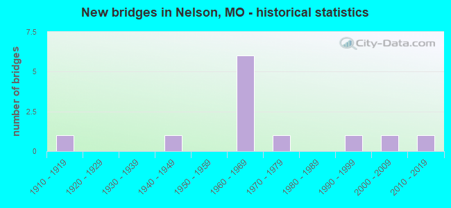
- New bridges - historical statistics
- 11910-1919
- 11940-1949
- 61960-1969
- 11970-1979
- 11990-1999
- 12000-2009
- 12010-2019

- Reconstructed bridges - Historical Statistics
- 11990-1999
- 02000-2009
- 12010-2019


- Bridge Condition - Deck
- 16.7%Very good
- 66.7%Good
- 16.7%Fair

- Bridge Condition - Superstructure
- 16.7%Excellent
- 16.7%Very good
- 33.3%Good
- 16.7%Satisfactory
- 16.7%Fair

- Bridge Condition - Substructure
- 16.7%Excellent
- 33.3%Very good
- 33.3%Good
- 16.7%Fair

- Bridge Condition - Channel
- 14.3%Very good
- 28.6%Satisfactory
- 57.1%Fair
Find on map >> Show street view
Structure Number: 22124, Location: S 5 T 49 N R 19 W (Lat: 39.049075, Lng: -93.028342), Route carried "on" structure: County highway 341, Year Built: 1910, Year Reconstructed: 1999, Status: Posted for load, Structure Length: 1.13m (3.71ft), Average Daily Traffic: 35 (year 2021), Truck Traffic: 10%, Average Future Daily Traffic: 39 (year 2041), Features Intersected: FLAT CR, Facility Carried by Structure: 184TH TRL
Minimum Vertical Clearance: 30+ m (98+ ft), Kilometerpoint: 2.414, Lanes on structure: 1, Owner: County Highway Agency, Approaching Roadway Width: 4.9m (16.1ft), Material/Design: Steel, Design/Construction: Girder and Floorbeam System, Number Of Spans In Main Unit: 1, Length of Maximum Span: 9.8m (32.2ft), Curb-To-Curb Width: 4.8m (15.7ft), Out-to-Out Width: 4.9m (16.1ft)
Condition: Deck: Good, Superstructure: Satisfactory, Substructure: Fair, Channel: Fair, Operating Rating: 13.5 metric tons, Method Used To Determine Operating Rating: Load Factor (LF), Inventory Rating: 8.1 metric tons, Method Used To Determine Inventory Rating: Load Factor (LF), Structural Evaluation: High priority of replacement, Deck Geometry: Equal to present desirable criteria, Waterway Adequacy: Better than present minimum criteria, Approach Roadway Alignment: Equal to present minimum criteria, Bridge Posting: Required (Relationship of Operating Rating to Maximum Legal Load: > 39.9% below), Length Of Structure Improvement: 0.18m (0.59ft), Designated Inspection Frequency: Every 24 months, Critical Feature Inspection Frequency: Every 24 months, Inspection Date: March 2022, Critical Feature Inspection Date: March 2022, Bridge Improvement Cost: $131,000, Roadway Improvement Cost: $13,000, Total Project Cost: $196,000 ( Estimate for 2022), Deck Structure Type: Concrete Cast-file-Place
Find on map >> Show street view
Structure Number: 22334, Location: S 24 T 49 N R 20 W (Lat: 39.016383, Lng: -93.061450), Route carried "on" structure: County highway 351, Year Built: 1977, Status: Open, Structure Length: 0.76m (2.49ft), Average Daily Traffic: 35 (year 2021), Truck Traffic: 10%, Average Future Daily Traffic: 39 (year 2041), Design Load: H 15, Features Intersected: BRUSH CR, Facility Carried by Structure: NORWAY AVE
Minimum Vertical Clearance: 30+ m (98+ ft), Kilometerpoint: 1.609, Lanes on structure: 2, Owner: County Highway Agency, Approaching Roadway Width: 7.9m (25.9ft), Material/Design: Concrete, Design/Construction: Culvert, Number Of Spans In Main Unit: 2, Length of Maximum Span: 3.7m (12.1ft)
Condition: Channel: Fair, Culverts: Satisfactory, Operating Rating: 49.5 metric tons, Method Used To Determine Operating Rating: Allowable Stress (AS), Inventory Rating: 16.2 metric tons, Method Used To Determine Inventory Rating: Allowable Stress (AS), Structural Evaluation: Somewhat better than minimum adequacy, Waterway Adequacy: Somewhat better than minimum adequacy, Approach Roadway Alignment: Equal to present desirable criteria, Designated Inspection Frequency: Every 24 months, Inspection Date: March 2020
Find on map >> Show street view
Structure Number: 22634, Location: S 23 T 49 N R 20 W (Lat: 39.003933, Lng: -93.085064), Route carried "on" structure: County highway 366, Year Built: 1995, Status: Open, Structure Length: 10.45m (34.28ft), Average Daily Traffic: 200 (year 2021), Truck Traffic: 10%, Average Future Daily Traffic: 220 (year 2041), Design Load: HS 20, Features Intersected: BLACKWATER RVR, Facility Carried by Structure: NATURE AVE
Minimum Vertical Clearance: 30+ m (98+ ft), Kilometerpoint: 0.644, Lanes on structure: 2, Owner: County Highway Agency, Approaching Roadway Width: 7.9m (25.9ft), Skew: 2 degrees, Material/Design: Steel, Design/Construction: Stringer/Multi-beam, Number Of Spans In Main Unit: 3, Length of Maximum Span: 39.6m (129.9ft), Curb-To-Curb Width: 7.3m (24.0ft), Out-to-Out Width: 8.0m (26.2ft)
Condition: Deck: Good, Superstructure: Very good, Substructure: Very good, Channel: Satisfactory, Operating Rating: 66.6 metric tons, Method Used To Determine Operating Rating: Allowable Stress (AS), Inventory Rating: 39.6 metric tons, Method Used To Determine Inventory Rating: Allowable Stress (AS), Structural Evaluation: Equal to present desirable criteria, Deck Geometry: Somewhat better than minimum adequacy, Waterway Adequacy: Equal to present minimum criteria, Approach Roadway Alignment: Equal to present minimum criteria, Designated Inspection Frequency: Every 24 months, Inspection Date: March 2020, Deck Structure Type: Concrete Precast Panels, Wearing Surface/Protective System: Wearing Surface: Monolithic Concrete
Find on map >> Show street view
Structure Number: 29829, Location: S 31 T 49 N R 19 W (Lat: 38.981467, Lng: -93.037919), Route carried "on" structure: County highway 369, Year Built: 2003, Status: Open, Structure Length: 7.96m (26.12ft), Average Daily Traffic: 40 (year 2021), Truck Traffic: 25%, Average Future Daily Traffic: 44 (year 2041), Design Load: HS 20, Features Intersected: BLACKWATER RVR, Facility Carried by Structure: OLEANDER AVE
Minimum Vertical Clearance: 30+ m (98+ ft), Kilometerpoint: 1.609, Lanes on structure: 2, Owner: County Highway Agency, Approaching Roadway Width: 7.3m (24.0ft), Skew: 3 degrees, Material/Design: Prestressed concrete continuous, Design/Construction: Stringer/Multi-beam, Number Of Spans In Main Unit: 3, Length of Maximum Span: 27.4m (89.9ft), Curb-To-Curb Width: 7.3m (24.0ft), Out-to-Out Width: 7.5m (24.6ft)
Condition: Deck: Good, Superstructure: Good, Substructure: Very good, Channel: Very good, Operating Rating: 56.7 metric tons, Method Used To Determine Operating Rating: Load Factor (LF), Inventory Rating: 34.2 metric tons, Method Used To Determine Inventory Rating: Load Factor (LF), Structural Evaluation: Better than present minimum criteria, Deck Geometry: Equal to present minimum criteria, Waterway Adequacy: Equal to present minimum criteria, Approach Roadway Alignment: Better than present minimum criteria, Designated Inspection Frequency: Every 24 months, Inspection Date: March 2022, Deck Structure Type: Concrete Precast Panels, Wearing Surface/Protective System: Wearing Surface: Monolithic Concrete
Find on map >> Show street view
Structure Number: 3523, Location: S 9 T 49 N R 19 W (Lat: 39.039508, Lng: -93.009861), Route carried "on" structure: State highway AA, Year Built: 2016, Status: Open, Structure Length: 3.52m (11.55ft), Average Daily Traffic: 116 (year 2021), Truck Traffic: 12%, Average Future Daily Traffic: 145 (year 2041), Features Intersected: FLAT CR
Minimum Vertical Clearance: 30+ m (98+ ft), Kilometerpoint: 5.704, Lanes on structure: 2, Owner: State Highway Agency, Approaching Roadway Width: 7.3m (24.0ft), Material/Design: Prestressed concrete, Design/Construction: Box Beam or Girders - Single/Spread, Number Of Spans In Main Unit: 3, Length of Maximum Span: 12.2m (40.0ft), Curb-To-Curb Width: 7.3m (24.0ft), Out-to-Out Width: 8.1m (26.6ft)
Condition: Deck: Very good, Superstructure: Excellent, Substructure: Excellent, Channel: Satisfactory, Operating Rating: 71.1 metric tons, Method Used To Determine Operating Rating: Load Factor (LF), Inventory Rating: 43.2 metric tons, Method Used To Determine Inventory Rating: Load Factor (LF), Structural Evaluation: Superior to present desirable criteria, Deck Geometry: Somewhat better than minimum adequacy, Waterway Adequacy: Superior to present desirable criteria, Approach Roadway Alignment: Equal to present desirable criteria, Designated Inspection Frequency: Every 24 months, Inspection Date: December 2021, Deck Structure Type: Concrete Cast-file-Place, Wearing Surface/Protective System: Wearing Surface: Monolithic Concrete, Deck Protection: Epoxy Coated Reinforcing
Find on map >> Show street view
Structure Number: 6201, Location: S 15 T 49 N R 20 W (Lat: 39.025286, Lng: -93.084686), Route carried "on" structure: State highway H, Year Built: 1949, Status: Open, Structure Length: 0.90m (2.95ft), Average Daily Traffic: 360 (year 2021), Truck Traffic: 11%, Average Future Daily Traffic: 450 (year 2041), Design Load: H 15, Features Intersected: BRUSH CR
Minimum Vertical Clearance: 30+ m (98+ ft), Kilometerpoint: 10.649, Lanes on structure: 2, Owner: State Highway Agency, Approaching Roadway Width: 7.3m (24.0ft), Skew: 3 degrees, Material/Design: Concrete continuous, Design/Construction: Culvert, Number Of Spans In Main Unit: 2, Length of Maximum Span: 3.4m (11.2ft), Curb-To-Curb Width: 8.5m (27.9ft), Out-to-Out Width: 9.1m (29.9ft)
Condition: Channel: Fair, Culverts: Satisfactory, Operating Rating: 44.1 metric tons, Method Used To Determine Operating Rating: Load Factor (LF), Inventory Rating: 26.1 metric tons, Method Used To Determine Inventory Rating: Load Factor (LF), Structural Evaluation: Equal to present minimum criteria, Deck Geometry: Equal to present minimum criteria, Waterway Adequacy: Equal to present minimum criteria, Approach Roadway Alignment: Equal to present desirable criteria, Designated Inspection Frequency: Every 24 months, Inspection Date: December 2021
Find on map >> Show street view
Structure Number: 8203, Location: S 7 T 48 N R 19 W (Lat: 38.949467, Lng: -93.034461), Route carried "on" structure: State highway Z, Year Built: 1962, Status: Open, Structure Length: 6.25m (20.51ft), Average Daily Traffic: 274 (year 2021), Truck Traffic: 11%, Average Future Daily Traffic: 370 (year 2041), Design Load: H 15, Features Intersected: IS 70
Minimum Vertical Clearance: 30+ m (98+ ft), Kilometerpoint: 4.226, Lanes on structure: 2, Lanes under structure: 4, Owner: State Highway Agency, Approaching Roadway Width: 6.1m (20.0ft), Material/Design: Concrete, Design/Construction: Slab, Number Of Spans In Main Unit: 4, Length of Maximum Span: 17.1m (56.1ft), Curb-To-Curb Width: 6.7m (22.0ft), Out-to-Out Width: 7.5m (24.6ft)
Condition: Deck: Fair, Superstructure: Fair, Substructure: Good, Operating Rating: 54.9 metric tons, Method Used To Determine Operating Rating: Allowable Stress (AS), Inventory Rating: 23.4 metric tons, Method Used To Determine Inventory Rating: Allowable Stress (AS), Structural Evaluation: Somewhat better than minimum adequacy, Deck Geometry: Meets minimum limits, Underclear: Meets minimum limits, Approach Roadway Alignment: Equal to present desirable criteria, Designated Inspection Frequency: Every 24 months, Inspection Date: July 2021, Deck Structure Type: Concrete Cast-file-Place, Wearing Surface/Protective System: Wearing Surface: Monolithic Concrete
Find on map >> Show street view
Structure Number: 8436, Location: S 19 T 49 N R 19 W (Lat: 39.006489, Lng: -93.035019), Route carried "on" structure: State highway H, Year Built: 1965, Year Reconstructed: 2017, Status: Open, Structure Length: 11.92m (39.11ft), Average Daily Traffic: 360 (year 2021), Truck Traffic: 11%, Average Future Daily Traffic: 450 (year 2041), Design Load: H 15, Features Intersected: SALT FORK CR
Minimum Vertical Clearance: 30+ m (98+ ft), Kilometerpoint: 16.573, Lanes on structure: 2, Owner: State Highway Agency, Approaching Roadway Width: 6.1m (20.0ft), Material/Design: Steel continuous, Design/Construction: Stringer/Multi-beam, Number Of Spans In Main Unit: 4, Length of Maximum Span: 41.1m (134.8ft), Curb-To-Curb Width: 7.9m (25.9ft), Out-to-Out Width: 8.7m (28.5ft)
Condition: Deck: Good, Superstructure: Good, Substructure: Good, Channel: Fair, Operating Rating: 31.5 metric tons, Method Used To Determine Operating Rating: Load Factor (LF), Inventory Rating: 18.9 metric tons, Method Used To Determine Inventory Rating: Load Factor (LF), Structural Evaluation: Somewhat better than minimum adequacy, Deck Geometry: Somewhat better than minimum adequacy, Waterway Adequacy: Somewhat better than minimum adequacy, Approach Roadway Alignment: Equal to present minimum criteria, Designated Inspection Frequency: Every 24 months, Inspection Date: December 2021, Deck Structure Type: Concrete Cast-file-Place, Wearing Surface/Protective System: Wearing Surface: Monolithic Concrete, Deck Protection: Epoxy Coated Reinforcing
Find on map >> Show street view
Structure Number: 11, Location: S 11 T 48 N R 20 W (Lat: 38.951725, Lng: -93.068289), Route carried "under" structure: Interstate 70, Year Built: 1961, Structure Length: 0. m, Average Daily Traffic: 14,383 (year 2021), Truck Traffic: 24%, Features Intersected: IS 70, Facility Carried by Structure: NITROGEN AVE S
Minimum Vertical Clearance: 4.85m (15.91ft), Kilometerpoint: 137.927, Lanes on structure: 2, Lanes under structure: 2, Material/Design: Prestressed concrete continuous, Design/Construction: Stringer/Multi-beam, Length of Maximum Span: 17.5m (57.4ft)
Find on map >> Show street view
Structure Number: 11, Location: S 11 T 48 N R 20 W (Lat: 38.951725, Lng: -93.068289), Route carried "under" structure: Interstate 70, Year Built: 1961, Structure Length: 0. m, Average Daily Traffic: 12,598 (year 2021), Truck Traffic: 24%, Features Intersected: IS 70, Facility Carried by Structure: NITROGEN AVE S
Minimum Vertical Clearance: 4.88m (16.01ft), Kilometerpoint: 264.404, Lanes on structure: 2, Lanes under structure: 2, Material/Design: Prestressed concrete continuous, Design/Construction: Stringer/Multi-beam, Length of Maximum Span: 17.5m (57.4ft)
Find on map >> Show street view
Structure Number: 8203, Location: S 7 T 48 N R 19 W (Lat: 38.949467, Lng: -93.034461), Route carried "under" structure: Interstate 70, Year Built: 1962, Structure Length: 0. m, Average Daily Traffic: 14,383 (year 2021), Truck Traffic: 24%, Features Intersected: IS 70, Facility Carried by Structure: RT Z S
Minimum Vertical Clearance: 4.88m (16.01ft), Kilometerpoint: 140.869, Lanes on structure: 2, Lanes under structure: 2, Material/Design: Concrete, Design/Construction: Slab, Length of Maximum Span: 17.1m (56.1ft)
Find on map >> Show street view
Structure Number: 8203, Location: S 7 T 48 N R 19 W (Lat: 38.949467, Lng: -93.034461), Route carried "under" structure: Interstate 70, Year Built: 1962, Structure Length: 0. m, Average Daily Traffic: 12,598 (year 2021), Truck Traffic: 24%, Features Intersected: IS 70, Facility Carried by Structure: RT Z S
Minimum Vertical Clearance: 4.90m (16.08ft), Kilometerpoint: 261.463, Lanes on structure: 2, Lanes under structure: 2, Material/Design: Concrete, Design/Construction: Slab, Length of Maximum Span: 17.1m (56.1ft)