Bridge Statistics for Neosho Rapids, Kansas (KS)
Condition, Traffic, Stress, Structural Evaluation, Project Costs
- National Bridge Inventory (NBI) Statistics
- 23Number of bridges
- 262ft / 79.6mTotal length
- $1,446,000Total costs
- 51,233Total average daily traffic
- 14,227Total average daily truck traffic
- National Bridge Inventory (NBI) Registered Bridges for Neosho Rapids
- No street view available for this location
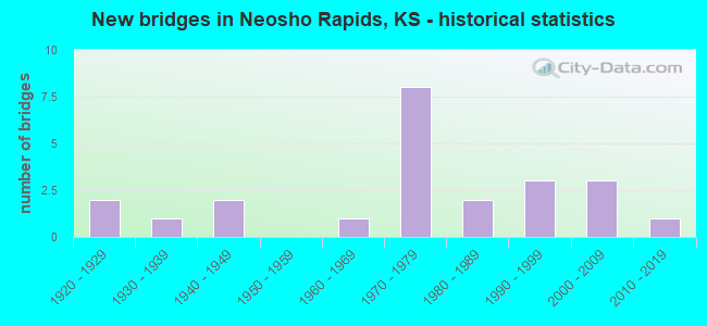
- New bridges - historical statistics
- 21920-1929
- 11930-1939
- 21940-1949
- 11960-1969
- 81970-1979
- 21980-1989
- 31990-1999
- 32000-2009
- 12010-2019
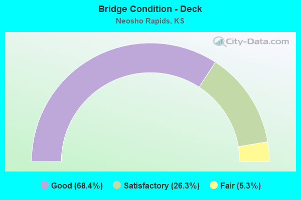
- Bridge Condition - Deck
- 68.4%Good
- 26.3%Satisfactory
- 5.3%Fair
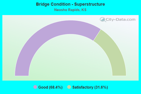
- Bridge Condition - Superstructure
- 68.4%Good
- 31.6%Satisfactory
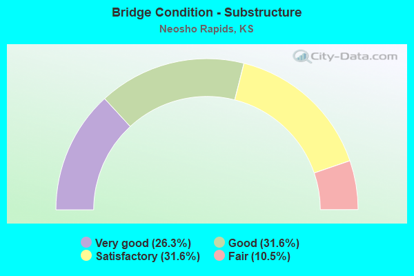
- Bridge Condition - Substructure
- 26.3%Very good
- 31.6%Good
- 31.6%Satisfactory
- 10.5%Fair
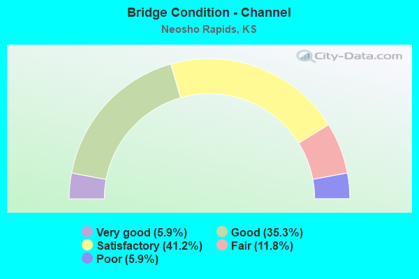
- Bridge Condition - Channel
- 5.9%Very good
- 35.3%Good
- 41.2%Satisfactory
- 11.8%Fair
- 5.9%Poor
Find on map >> Show street view
Structure Number: 56035, Location: 0.5W OF NEOSHO RAPIDS (Lat: 38.367750, Lng: -96.002083), Route carried "on" structure: County highway 418, Year Built: 1940, Status: Posted for load, Structure Length: 14.42m (47.31ft), Average Daily Traffic: 152 (year 2007), Truck Traffic: 10%, Average Future Daily Traffic: 165 (year 2039), Design Load: HS 20, Features Intersected: NEOSHO RIVER, Facility Carried by Structure: RD 145 963.2-524.5
Minimum Vertical Clearance: 30.47m (99.97ft), Kilometerpoint: 0.000, Lanes on structure: 2, Owner: County Highway Agency, Approaching Roadway Width: 7.3m (24.0ft), Skew: 3 degrees, Material/Design: Steel continuous, Design/Construction: Truss - Thru, Number Of Spans In Main Unit: 3, Length of Maximum Span: 55.3m (181.4ft), Curb or Sidewalk Widths: Left: 0.2m (0.7ft), Right: 0.2m (0.7ft), Curb-To-Curb Width: 7.3m (24.0ft), Out-to-Out Width: 7.8m (25.6ft)
Condition: Deck: Satisfactory, Superstructure: Satisfactory, Substructure: Satisfactory, Channel: Satisfactory, Operating Rating: 36.3 metric tons, Method Used To Determine Operating Rating: Load Factor (LF), Inventory Rating: 21.8 metric tons, Method Used To Determine Inventory Rating: Load Factor (LF), Structural Evaluation: Equal to present minimum criteria, Deck Geometry: Somewhat better than minimum adequacy, Waterway Adequacy: Better than present minimum criteria, Approach Roadway Alignment: Equal to present minimum criteria, Length Of Structure Improvement: 46.31m (151.94ft), Designated Inspection Frequency: Every 24 months, Critical Feature Inspection Frequency: Every 24 months, Inspection Date: March 2021, Critical Feature Inspection Date: March 2021, Bridge Improvement Cost: $473,000, Roadway Improvement Cost: $152,000, Total Project Cost: $719,000, Deck Structure Type: Concrete Cast-file-Place, Wearing Surface/Protective System: Wearing Surface: Monolithic Concrete
Find on map >> Show street view
Structure Number: 56079, Location: 9.0E OF EMPORIA (Lat: 38.412111, Lng: -95.993361), Route carried "on" structure: County highway 2066, Year Built: 1999, Status: Open, Structure Length: 4.04m (13.25ft), Average Daily Traffic: 605 (year 2007), Truck Traffic: 10%, Average Future Daily Traffic: 630 (year 2039), Design Load: HS 20, Features Intersected: DRY CREEK, Facility Carried by Structure: US 50 963.6-519.0
Minimum Vertical Clearance: 30.47m (99.97ft), Kilometerpoint: 0.000, Lanes on structure: 2, Owner: County Highway Agency, Approaching Roadway Width: 7.3m (24.0ft), Material/Design: Concrete continuous, Design/Construction: Slab, Number Of Spans In Main Unit: 3, Length of Maximum Span: 15.8m (51.8ft), Curb-To-Curb Width: 9.1m (29.9ft), Out-to-Out Width: 9.8m (32.2ft)
Condition: Deck: Good, Superstructure: Good, Substructure: Good, Channel: Good, Operating Rating: 79.4 metric tons, Method Used To Determine Operating Rating: Load Factor (LF), Inventory Rating: 47.5 metric tons, Method Used To Determine Inventory Rating: Load Factor (LF), Structural Evaluation: Better than present minimum criteria, Deck Geometry: Equal to present minimum criteria, Waterway Adequacy: Better than present minimum criteria, Approach Roadway Alignment: Equal to present desirable criteria, Length Of Structure Improvement: 4.36m (14.30ft), Designated Inspection Frequency: Every 24 months, Inspection Date: March 2021, Bridge Improvement Cost: $312,000, Roadway Improvement Cost: $31,000, Total Project Cost: $468,000, Deck Structure Type: Concrete Cast-file-Place
Find on map >> Show street view
Structure Number: 64580-00015, Location: 2.7 MI NNW OF HQ (Lat: 38.347500, Lng: -95.977000), Route carried "on" structure: County highway 130, Year Built: 1935, Year Reconstructed: 1966, Status: Posted for load, Structure Length: 3.29m (10.79ft), Average Daily Traffic: 25 (year 2021), Average Future Daily Traffic: 30 (year 2040), Design Load: H 15, Features Intersected: PLUM CREEK
Minimum Vertical Clearance: 30.48m (100.00ft), Kilometerpoint: 33.152, Lanes on structure: 2, Owner: Bureau of Fish and Wildlife, Approaching Roadway Width: 7.3m (24.0ft), Material/Design: Steel, Design/Construction: Truss - Thru, Number Of Spans In Main Unit: 1, Number Of Approach Spans: 2, Length of Maximum Span: 21.3m (69.9ft), Curb or Sidewalk Widths: Left: 0.2m (0.7ft), Right: 0.1m (0.3ft), Curb-To-Curb Width: 6.2m (20.3ft), Out-to-Out Width: 6.5m (21.3ft)
Condition: Deck: Satisfactory, Superstructure: Satisfactory, Substructure: Satisfactory, Channel: Satisfactory, Operating Rating: 10.9 metric tons, Method Used To Determine Operating Rating: Allowable Stress (AS), Inventory Rating: 4.5 metric tons, Method Used To Determine Inventory Rating: Allowable Stress (AS), Structural Evaluation: High priority of corrective action, Deck Geometry: Somewhat better than minimum adequacy, Waterway Adequacy: Better than present minimum criteria, Approach Roadway Alignment: Equal to present minimum criteria, Bridge Posting: Required (Relationship of Operating Rating to Maximum Legal Load: > 39.9% below), Designated Inspection Frequency: Every 24 months, Critical Feature Inspection Frequency: Every 24 months, Inspection Date: January 2021, Critical Feature Inspection Date: January 2021, Deck Structure Type: Concrete Cast-file-Place, Wearing Surface/Protective System: Wearing Surface: Bituminous
Find on map >> Show street view
Structure Number: 64580-00128, Location: 2.5 MI N OF HQ (Lat: 38.347000, Lng: -95.961667), Route carried "on" structure: County highway 130, Year Built: 1927, Status: Open, Structure Length: 0.79m (2.59ft), Average Daily Traffic: 25 (year 2021), Average Future Daily Traffic: 30 (year 2040), Design Load: H 15, Features Intersected: UNNAMED NATURAL DRAINAGE
Minimum Vertical Clearance: 30.48m (100.00ft), Kilometerpoint: 50.372, Lanes on structure: 2, Owner: Bureau of Fish and Wildlife, Approaching Roadway Width: 7.3m (24.0ft), Material/Design: Concrete, Design/Construction: Culvert, Number Of Spans In Main Unit: 3, Length of Maximum Span: 2.4m (7.9ft), Curb-To-Curb Width: 8.5m (27.9ft), Out-to-Out Width: 9.1m (29.9ft)
Condition: Channel: Satisfactory, Culverts: Good, Operating Rating: 32.7 metric tons, Method Used To Determine Operating Rating: Field evaluation and documented engineering judgment, Inventory Rating: 24.5 metric tons, Method Used To Determine Inventory Rating: Field evaluation and documented engineering judgment, Structural Evaluation: Equal to present minimum criteria, Deck Geometry: Better than present minimum criteria, Waterway Adequacy: Better than present minimum criteria, Approach Roadway Alignment: Equal to present desirable criteria, Designated Inspection Frequency: Every 24 months, Inspection Date: January 2021, Deck Structure Type: Concrete Cast-file-Place, Wearing Surface/Protective System: Wearing Surface: Gravel
Find on map >> Show street view
Structure Number: 16096950524, Location: 2.0S 4.5W OF LEBO (Lat: 38.375931, Lng: -95.937333), Route carried "on" structure: County highway , Year Built: 1990, Status: Open, Structure Length: 0.91m (2.99ft), Average Daily Traffic: 20 (year 2013), Average Future Daily Traffic: 25 (year 2040), Design Load: HS 20, Features Intersected: TROUBLESOME CREEK, Facility Carried by Structure: 24TH. RD. 301
Minimum Vertical Clearance: 30.47m (99.97ft), Kilometerpoint: 0.000, Lanes on structure: 2, Owner: County Highway Agency, Approaching Roadway Width: 6.0m (19.7ft), Material/Design: Concrete, Design/Construction: Culvert, Number Of Spans In Main Unit: 3, Length of Maximum Span: 3.0m (9.8ft), Curb-To-Curb Width: 7.7m (25.3ft), Out-to-Out Width: 8.4m (27.6ft)
Condition: Channel: Good, Culverts: Good, Operating Rating: 49.5 metric tons, Method Used To Determine Operating Rating: Load Factor (LF), Inventory Rating: 29.7 metric tons, Method Used To Determine Inventory Rating: Load Factor (LF), Structural Evaluation: Better than present minimum criteria, Deck Geometry: Equal to present minimum criteria, Waterway Adequacy: Equal to present desirable criteria, Approach Roadway Alignment: Equal to present desirable criteria, Designated Inspection Frequency: Every 24 months, Inspection Date: April 2020, Other Special Inspection Date: December 2021, Wearing Surface/Protective System: Wearing Surface: Gravel
Find on map >> Show street view
Structure Number: 16096960526, Location: 3.0S 4.4W OF LEBO (Lat: 38.361361, Lng: -95.938978), Route carried "on" structure: County highway , Year Built: 1980, Status: Posted for load, Structure Length: 0.92m (3.02ft), Average Daily Traffic: 35 (year 2013), Average Future Daily Traffic: 42 (year 2040), Features Intersected: TROUBLESOME CREEK, Facility Carried by Structure: 23RD. RD. 205
Minimum Vertical Clearance: 30.47m (99.97ft), Kilometerpoint: 0.000, Lanes on structure: 2, Owner: County Highway Agency, Approaching Roadway Width: 5.6m (18.4ft), Material/Design: Steel, Design/Construction: Stringer/Multi-beam, Number Of Spans In Main Unit: 1, Length of Maximum Span: 9.1m (29.9ft), Curb-To-Curb Width: 7.3m (24.0ft), Out-to-Out Width: 7.4m (24.3ft)
Condition: Deck: Good, Superstructure: Satisfactory, Substructure: Satisfactory, Channel: Satisfactory, Operating Rating: 12.5 metric tons, Method Used To Determine Operating Rating: Load Factor (LF), Inventory Rating: 7.5 metric tons, Method Used To Determine Inventory Rating: Load Factor (LF), Structural Evaluation: High priority of corrective action, Deck Geometry: Equal to present minimum criteria, Waterway Adequacy: Somewhat better than minimum adequacy, Approach Roadway Alignment: Equal to present desirable criteria, Bridge Posting: Required (Relationship of Operating Rating to Maximum Legal Load: > 39.9% below), Designated Inspection Frequency: Every 24 months, Inspection Date: April 2020, Other Special Inspection Date: December 2020, Deck Structure Type: Corrugated Steel, Wearing Surface/Protective System: Wearing Surface: Gravel
Find on map >> Show street view
Structure Number: 5609579053, Location: 5.0N 6.9E OF OLPE (Lat: 38.332306, Lng: -96.044528), Route carried "on" structure: County highway , Year Built: 1991, Status: Open, Structure Length: 0.69m (2.26ft), Average Daily Traffic: 25 (year 2007), Average Future Daily Traffic: 25 (year 2039), Design Load: HS 20, Features Intersected: STREAM, Facility Carried by Structure: RD 120 (T.9-120.0)
Minimum Vertical Clearance: 30.47m (99.97ft), Kilometerpoint: 0.000, Lanes on structure: 2, Owner: County Highway Agency, Approaching Roadway Width: 5.7m (18.7ft), Material/Design: Steel, Design/Construction: Stringer/Multi-beam, Number Of Spans In Main Unit: 1, Length of Maximum Span: 6.6m (21.7ft), Curb-To-Curb Width: 7.1m (23.3ft), Out-to-Out Width: 7.3m (24.0ft)
Condition: Deck: Good, Superstructure: Good, Substructure: Good, Channel: Good, Operating Rating: 62.9 metric tons, Method Used To Determine Operating Rating: Load Factor (LF), Inventory Rating: 37.6 metric tons, Method Used To Determine Inventory Rating: Load Factor (LF), Structural Evaluation: Better than present minimum criteria, Deck Geometry: Somewhat better than minimum adequacy, Waterway Adequacy: Meets minimum limits, Approach Roadway Alignment: Equal to present desirable criteria, Designated Inspection Frequency: Every 24 months, Inspection Date: March 2021, Deck Structure Type: Corrugated Steel, Wearing Surface/Protective System: Wearing Surface: Bituminous
Find on map >> Show street view
Structure Number: 560963005301, Location: 1.5N 2.5W OF HARTFORD (Lat: 38.330611, Lng: -96.005667), Route carried "on" structure: County highway , Year Built: 2003, Status: Open, Structure Length: 0.75m (2.46ft), Average Daily Traffic: 20 (year 2007), Average Future Daily Traffic: 20 (year 2039), Design Load: HS 20, Features Intersected: STREAM, Facility Carried by Structure: RD W 963-530.1
Minimum Vertical Clearance: 30.47m (99.97ft), Kilometerpoint: 0.000, Lanes on structure: 2, Owner: County Highway Agency, Approaching Roadway Width: 5.4m (17.7ft), Material/Design: Steel, Design/Construction: Stringer/Multi-beam, Number Of Spans In Main Unit: 1, Length of Maximum Span: 6.9m (22.6ft), Curb-To-Curb Width: 7.1m (23.3ft), Out-to-Out Width: 7.3m (24.0ft)
Condition: Deck: Good, Superstructure: Satisfactory, Substructure: Satisfactory, Channel: Good, Operating Rating: 51.3 metric tons, Method Used To Determine Operating Rating: Load Factor (LF), Inventory Rating: 30.8 metric tons, Method Used To Determine Inventory Rating: Load Factor (LF), Structural Evaluation: Equal to present minimum criteria, Deck Geometry: Somewhat better than minimum adequacy, Waterway Adequacy: Somewhat better than minimum adequacy, Approach Roadway Alignment: Better than present minimum criteria, Length Of Structure Improvement: 0.85m (2.79ft), Designated Inspection Frequency: Every 24 months, Inspection Date: March 2021, Bridge Improvement Cost: $22,000, Roadway Improvement Cost: $2,000, Total Project Cost: $32,000, Deck Structure Type: Corrugated Steel, Wearing Surface/Protective System: Wearing Surface: Bituminous
Find on map >> Show street view
Structure Number: 56096350524, Location: N. EDGE OF NEOSHO RAPIDS (Lat: 38.375972, Lng: -95.996750), Route carried "on" structure: County highway , Year Built: 1988, Status: Open, Structure Length: 3.72m (12.20ft), Average Daily Traffic: 20 (year 2007), Average Future Daily Traffic: 20 (year 2039), Design Load: H 20, Features Intersected: DRY CREEK, Facility Carried by Structure: RD 150 963.5-524.0
Minimum Vertical Clearance: 30.47m (99.97ft), Kilometerpoint: 0.000, Lanes on structure: 2, Owner: County Highway Agency, Approaching Roadway Width: 5.4m (17.7ft), Skew: 3 degrees, Material/Design: Concrete continuous, Design/Construction: Slab, Number Of Spans In Main Unit: 3, Length of Maximum Span: 14.6m (47.9ft), Curb or Sidewalk Widths: Left: 0.3m (1.0ft), Right: 0.3m (1.0ft), Curb-To-Curb Width: 7.3m (24.0ft), Out-to-Out Width: 7.9m (25.9ft)
Condition: Deck: Good, Superstructure: Good, Substructure: Satisfactory, Channel: Fair, Operating Rating: 63.4 metric tons, Method Used To Determine Operating Rating: Load Factor (LF), Inventory Rating: 38.0 metric tons, Method Used To Determine Inventory Rating: Load Factor (LF), Structural Evaluation: Equal to present minimum criteria, Deck Geometry: Equal to present minimum criteria, Waterway Adequacy: Equal to present minimum criteria, Approach Roadway Alignment: Equal to present minimum criteria, Designated Inspection Frequency: Every 24 months, Inspection Date: March 2021, Deck Structure Type: Concrete Cast-file-Place, Wearing Surface/Protective System: Wearing Surface: Monolithic Concrete
Find on map >> Show street view
Structure Number: 5609637052, Location: 2.0N OF NEOSHO RAPIDS (Lat: 38.405083, Lng: -95.991167), Route carried "on" structure: County highway , Year Built: 1923, Status: Posted for load, Structure Length: 2.01m (6.59ft), Average Daily Traffic: 50 (year 2007), Average Future Daily Traffic: 50 (year 2039), Features Intersected: DRY CREEK, Facility Carried by Structure: RD 170 963.7-520.0
Minimum Vertical Clearance: 30.47m (99.97ft), Kilometerpoint: 0.000, Lanes on structure: 2, Owner: County Highway Agency, Approaching Roadway Width: 4.8m (15.7ft), Material/Design: Concrete, Design/Construction: Tee Beam, Number Of Spans In Main Unit: 2, Length of Maximum Span: 9.6m (31.5ft), Curb or Sidewalk Widths: Left: 0.4m (1.3ft), Right: 0.4m (1.3ft), Curb-To-Curb Width: 5.9m (19.4ft), Out-to-Out Width: 6.7m (22.0ft)
Condition: Deck: Fair, Superstructure: Satisfactory, Substructure: Fair, Channel: Poor, Operating Rating: 30.0 metric tons, Method Used To Determine Operating Rating: Load Factor (LF), Inventory Rating: 18.0 metric tons, Method Used To Determine Inventory Rating: Load Factor (LF), Structural Evaluation: Somewhat better than minimum adequacy, Deck Geometry: Meets minimum limits, Waterway Adequacy: Equal to present minimum criteria, Approach Roadway Alignment: Equal to present desirable criteria, Length Of Structure Improvement: 9.18m (30.12ft), Designated Inspection Frequency: Every 24 months, Inspection Date: March 2021, Bridge Improvement Cost: $67,000, Roadway Improvement Cost: $30,000, Total Project Cost: $112,000, Deck Structure Type: Concrete Cast-file-Place, Wearing Surface/Protective System: Wearing Surface: Bituminous
Find on map >> Show street view
Structure Number: 56096550526, Location: 0.5E of Neosho Rapids (Lat: 38.361556, Lng: -95.979444), Route carried "on" structure: County highway 2305, Year Built: 2015, Status: Open, Structure Length: 0.92m (3.02ft), Average Daily Traffic: 20 (year 2007), Truck Traffic: 10%, Average Future Daily Traffic: 20 (year 2039), Features Intersected: PLUM CREEK, Facility Carried by Structure: RD 140 (Y.0-140)
Minimum Vertical Clearance: 30.47m (99.97ft), Kilometerpoint: 0.000, Lanes on structure: 2, Owner: County Highway Agency, Approaching Roadway Width: 5.7m (18.7ft), Material/Design: Steel, Design/Construction: Stringer/Multi-beam, Number Of Spans In Main Unit: 1, Length of Maximum Span: 8.9m (29.2ft), Curb-To-Curb Width: 7.2m (23.6ft), Out-to-Out Width: 7.3m (24.0ft)
Condition: Deck: Good, Superstructure: Good, Substructure: Good, Channel: Satisfactory, Operating Rating: 47.6 metric tons, Method Used To Determine Operating Rating: Load Factor (LF), Inventory Rating: 28.6 metric tons, Method Used To Determine Inventory Rating: Load Factor (LF), Structural Evaluation: Better than present minimum criteria, Deck Geometry: Somewhat better than minimum adequacy, Waterway Adequacy: Somewhat better than minimum adequacy, Approach Roadway Alignment: Equal to present desirable criteria, Designated Inspection Frequency: Every 24 months, Inspection Date: March 2021, Deck Structure Type: Corrugated Steel, Wearing Surface/Protective System: Wearing Surface: Bituminous
Find on map >> Show street view
Structure Number: 56096560524, Location: 0.8E OF NEOSHO RAPIDS (Lat: 38.376000, Lng: -95.975750), Route carried "on" structure: County highway , Year Built: 1940, Status: Posted for load, Structure Length: 1.05m (3.44ft), Average Daily Traffic: 60 (year 2007), Average Future Daily Traffic: 60 (year 2039), Features Intersected: PLUM CREEK, Facility Carried by Structure: RD 150 965.6-524.0
Minimum Vertical Clearance: 30.47m (99.97ft), Kilometerpoint: 0.000, Lanes on structure: 2, Owner: County Highway Agency, Approaching Roadway Width: 5.4m (17.7ft), Material/Design: Steel, Design/Construction: Stringer/Multi-beam, Number Of Spans In Main Unit: 1, Length of Maximum Span: 10.4m (34.1ft), Curb or Sidewalk Widths: Left: 0.2m (0.7ft), Right: 0.2m (0.7ft), Curb-To-Curb Width: 5.4m (17.7ft), Out-to-Out Width: 5.8m (19.0ft)
Condition: Deck: Satisfactory, Superstructure: Satisfactory, Substructure: Fair, Channel: Fair, Operating Rating: 15.0 metric tons, Method Used To Determine Operating Rating: Load Factor (LF), Inventory Rating: 9.1 metric tons, Method Used To Determine Inventory Rating: Load Factor (LF), Structural Evaluation: High priority of corrective action, Deck Geometry: High priority of corrective action, Waterway Adequacy: Equal to present minimum criteria, Approach Roadway Alignment: Somewhat better than minimum adequacy, Bridge Posting: Required (Relationship of Operating Rating to Maximum Legal Load: > 39.9% below), Length Of Structure Improvement: 1.25m (4.10ft), Designated Inspection Frequency: Every 24 months, Inspection Date: March 2021, Bridge Improvement Cost: $48,000, Roadway Improvement Cost: $5,000, Total Project Cost: $71,000, Deck Structure Type: Concrete Cast-file-Place, Wearing Surface/Protective System: Wearing Surface: Gravel
Find on map >> Show street view
Structure Number: 560967005221, Location: 1.0 E 1.0 N NEOSHO RAPIDS (Lat: 38.388250, Lng: -95.968806), Route carried "on" structure: County highway , Year Built: 2002, Status: Open, Structure Length: 0.91m (2.99ft), Average Daily Traffic: 50 (year 2007), Average Future Daily Traffic: 50 (year 2039), Features Intersected: PLUM CREEK, Facility Carried by Structure: RD Y (Y.0-159.8)
Minimum Vertical Clearance: 30.47m (99.97ft), Kilometerpoint: 0.000, Lanes on structure: 2, Owner: County Highway Agency, Approaching Roadway Width: 5.4m (17.7ft), Material/Design: Steel, Design/Construction: Stringer/Multi-beam, Number Of Spans In Main Unit: 1, Length of Maximum Span: 8.7m (28.5ft), Curb-To-Curb Width: 7.1m (23.3ft), Out-to-Out Width: 7.3m (24.0ft)
Condition: Deck: Good, Superstructure: Good, Substructure: Good, Channel: Satisfactory, Operating Rating: 50.9 metric tons, Method Used To Determine Operating Rating: Load Factor (LF), Inventory Rating: 30.5 metric tons, Method Used To Determine Inventory Rating: Load Factor (LF), Structural Evaluation: Better than present minimum criteria, Deck Geometry: Somewhat better than minimum adequacy, Waterway Adequacy: Somewhat better than minimum adequacy, Approach Roadway Alignment: Better than present minimum criteria, Designated Inspection Frequency: Every 24 months, Inspection Date: March 2021, Deck Structure Type: Corrugated Steel, Wearing Surface/Protective System: Wearing Surface: Bituminous
Find on map >> Show street view
Structure Number: 56096710522, Location: 1.0E 1.0N NEOSHO RAPIDS (Lat: 38.390444, Lng: -95.968278), Route carried "on" structure: County highway , Year Built: 2009, Status: Open, Structure Length: 0.94m (3.08ft), Average Daily Traffic: 50 (year 2007), Average Future Daily Traffic: 50 (year 2039), Design Load: HS 20, Features Intersected: PLUM CREEK, Facility Carried by Structure: RD 160 967.1-522
Minimum Vertical Clearance: 30.47m (99.97ft), Kilometerpoint: 0.000, Lanes on structure: 2, Owner: County Highway Agency, Approaching Roadway Width: 5.1m (16.7ft), Material/Design: Steel, Design/Construction: Stringer/Multi-beam, Number Of Spans In Main Unit: 1, Length of Maximum Span: 8.8m (28.9ft), Curb-To-Curb Width: 7.1m (23.3ft), Out-to-Out Width: 7.3m (24.0ft)
Condition: Deck: Good, Superstructure: Good, Substructure: Satisfactory, Channel: Good, Operating Rating: 48.3 metric tons, Method Used To Determine Operating Rating: Load Factor (LF), Inventory Rating: 28.8 metric tons, Method Used To Determine Inventory Rating: Load Factor (LF), Structural Evaluation: Equal to present minimum criteria, Deck Geometry: Somewhat better than minimum adequacy, Waterway Adequacy: Somewhat better than minimum adequacy, Approach Roadway Alignment: Equal to present desirable criteria, Length Of Structure Improvement: 0.91m (2.99ft), Designated Inspection Frequency: Every 24 months, Inspection Date: March 2021, Bridge Improvement Cost: $30,000, Roadway Improvement Cost: $3,000, Total Project Cost: $44,000, Deck Structure Type: Corrugated Steel, Wearing Surface/Protective System: Wearing Surface: Bituminous
Find on map >> Show street view
Structure Number: 999903500160471, Location: LYON -COFFEY CO LINE (Lat: 38.411667, Lng: -95.950278), Route carried "on" structure: ServiceCounty highway 392, Year Built: 1972, Status: Open, Structure Length: 8.19m (26.87ft), Average Daily Traffic: 22 (year 2020), Average Future Daily Traffic: 10,231 (year 2041), Design Load: H 20, Features Intersected: I35 HWY, Facility Carried by Structure: CO LINE LOCAL ROAD
Minimum Vertical Clearance: 30.47m (99.97ft), Kilometerpoint: 2.474, Lanes on structure: 2, Lanes under structure: 4, Owner: State Highway Agency, Approaching Roadway Width: 7.3m (24.0ft), Material/Design: Concrete continuous, Design/Construction: Box Beam or Girders - Multiple, Number Of Spans In Main Unit: 4, Length of Maximum Span: 28.3m (92.8ft), Curb-To-Curb Width: 8.5m (27.9ft), Out-to-Out Width: 9.0m (29.5ft)
Condition: Deck: Good, Superstructure: Good, Substructure: Very good, Operating Rating: 66.4 metric tons, Method Used To Determine Operating Rating: Load Factor (LF), Inventory Rating: 39.8 metric tons, Method Used To Determine Inventory Rating: Load Factor (LF), Structural Evaluation: Better than present minimum criteria, Deck Geometry: Better than present minimum criteria, Underclear: Equal to present minimum criteria, Approach Roadway Alignment: Somewhat better than minimum adequacy, Length Of Structure Improvement: 26.86m (88.12ft), Designated Inspection Frequency: Every 24 months, Inspection Date: March 2020, Deck Structure Type: Concrete Cast-file-Place, Wearing Surface/Protective System: Wearing Surface: Monolithic Concrete
Find on map >> Show street view
Structure Number: 999903500561271, Location: 10.58 MI E OF K-99 (Lat: 38.408056, Lng: -95.991944), Route carried "on" structure: Interstate 35, Year Built: 1976, Status: Open, Structure Length: 4.34m (14.24ft), Average Daily Traffic: 8,820 (year 2020), Truck Traffic: 26%, Average Future Daily Traffic: 12,116 (year 2041), Design Load: HS 20+Mod, Features Intersected: DRY CREEK
Minimum Vertical Clearance: 30.47m (99.97ft), Kilometerpoint: 39.703, Lanes on structure: 2, Base Highway Network: Yes, Owner: State Highway Agency, Approaching Roadway Width: 12.2m (40.0ft), Material/Design: Concrete continuous, Design/Construction: Slab, Number Of Spans In Main Unit: 3, Length of Maximum Span: 17.1m (56.1ft), Curb-To-Curb Width: 12.2m (40.0ft), Out-to-Out Width: 12.8m (42.0ft)
Condition: Deck: Good, Superstructure: Good, Substructure: Very good, Channel: Very good, Operating Rating: 63.5 metric tons, Method Used To Determine Operating Rating: Load Factor (LF), Inventory Rating: 38.1 metric tons, Method Used To Determine Inventory Rating: Load Factor (LF), Structural Evaluation: Better than present minimum criteria, Deck Geometry: Better than present minimum criteria, Waterway Adequacy: Equal to present desirable criteria, Approach Roadway Alignment: Equal to present desirable criteria, Length Of Structure Improvement: 14.25m (46.75ft), Designated Inspection Frequency: Every 24 months, Inspection Date: May 2020, Deck Structure Type: Concrete Cast-file-Place, Wearing Surface/Protective System: Wearing Surface: Low Slump Concrete
Find on map >> Show street view
Structure Number: 999903500561281, Location: 10.59 MI E OF K-99 (Lat: 38.408333, Lng: -95.991667), Route carried "on" structure: Interstate 35, Year Built: 1976, Status: Open, Structure Length: 4.34m (14.24ft), Average Daily Traffic: 8,820 (year 2020), Truck Traffic: 26%, Average Future Daily Traffic: 12,116 (year 2041), Design Load: HS 20+Mod, Features Intersected: DRY CREEK
Minimum Vertical Clearance: 30.47m (99.97ft), Kilometerpoint: 39.891, Lanes on structure: 3, Base Highway Network: Yes, Owner: State Highway Agency, Approaching Roadway Width: 12.2m (40.0ft), Material/Design: Concrete continuous, Design/Construction: Slab, Number Of Spans In Main Unit: 3, Length of Maximum Span: 17.1m (56.1ft), Curb-To-Curb Width: 14.6m (47.9ft), Out-to-Out Width: 15.2m (49.9ft)
Condition: Deck: Good, Superstructure: Good, Substructure: Very good, Channel: Good, Operating Rating: 63.5 metric tons, Method Used To Determine Operating Rating: Load Factor (LF), Inventory Rating: 38.1 metric tons, Method Used To Determine Inventory Rating: Load Factor (LF), Structural Evaluation: Better than present minimum criteria, Deck Geometry: Meets minimum limits, Waterway Adequacy: Equal to present desirable criteria, Approach Roadway Alignment: Equal to present desirable criteria, Length Of Structure Improvement: 14.25m (46.75ft), Designated Inspection Frequency: Every 24 months, Inspection Date: May 2020, Deck Structure Type: Concrete Cast-file-Place, Wearing Surface/Protective System: Wearing Surface: Low Slump Concrete
Find on map >> Show street view
Structure Number: 999903500561291, Location: JCT I35&K130 (Lat: 38.408333, Lng: -95.986944), Route carried "on" structure: Interstate 35, Year Built: 1975, Status: Open, Structure Length: 5.50m (18.04ft), Average Daily Traffic: 7,344 (year 2020), Truck Traffic: 32%, Average Future Daily Traffic: 10,288 (year 2041), Design Load: HS 20+Mod, Features Intersected: RS1643, K130 HWY
Minimum Vertical Clearance: 30.47m (99.97ft), Kilometerpoint: 40.298, Lanes on structure: 2, Lanes under structure: 2, Base Highway Network: Yes, Owner: State Highway Agency, Approaching Roadway Width: 12.2m (40.0ft), Material/Design: Concrete continuous, Design/Construction: Box Beam or Girders - Multiple, Number Of Spans In Main Unit: 3, Length of Maximum Span: 26.8m (87.9ft), Curb-To-Curb Width: 12.2m (40.0ft), Out-to-Out Width: 12.8m (42.0ft)
Condition: Deck: Good, Superstructure: Good, Substructure: Very good, Operating Rating: 57.3 metric tons, Method Used To Determine Operating Rating: Load Factor (LF), Inventory Rating: 34.4 metric tons, Method Used To Determine Inventory Rating: Load Factor (LF), Structural Evaluation: Better than present minimum criteria, Deck Geometry: Better than present minimum criteria, Underclear: Equal to present minimum criteria, Approach Roadway Alignment: Equal to present desirable criteria, Length Of Structure Improvement: 18.05m (59.22ft), Designated Inspection Frequency: Every 24 months, Inspection Date: May 2020, Deck Structure Type: Concrete Cast-file-Place, Wearing Surface/Protective System: Wearing Surface: Low Slump Concrete
Find on map >> Show street view
Structure Number: 999903500561301, Location: JCT I35 & K-130 HWY (Lat: 38.408056, Lng: -95.986944), Route carried "on" structure: Interstate 35, Year Built: 1975, Status: Open, Structure Length: 5.50m (18.04ft), Average Daily Traffic: 8,820 (year 2020), Truck Traffic: 26%, Average Future Daily Traffic: 12,116 (year 2041), Design Load: HS 20+Mod, Features Intersected: K-130 HWY
Minimum Vertical Clearance: 30.47m (99.97ft), Kilometerpoint: 40.110, Lanes on structure: 2, Lanes under structure: 2, Base Highway Network: Yes, Owner: State Highway Agency, Approaching Roadway Width: 12.2m (40.0ft), Material/Design: Concrete continuous, Design/Construction: Box Beam or Girders - Multiple, Number Of Spans In Main Unit: 3, Length of Maximum Span: 26.8m (87.9ft), Curb-To-Curb Width: 12.2m (40.0ft), Out-to-Out Width: 12.8m (42.0ft)
Condition: Deck: Satisfactory, Superstructure: Good, Substructure: Good, Operating Rating: 57.3 metric tons, Method Used To Determine Operating Rating: Load Factor (LF), Inventory Rating: 34.4 metric tons, Method Used To Determine Inventory Rating: Load Factor (LF), Structural Evaluation: Better than present minimum criteria, Deck Geometry: Better than present minimum criteria, Underclear: Equal to present minimum criteria, Approach Roadway Alignment: Equal to present desirable criteria, Length Of Structure Improvement: 18.05m (59.22ft), Designated Inspection Frequency: Every 24 months, Inspection Date: May 2020, Deck Structure Type: Concrete Cast-file-Place, Wearing Surface/Protective System: Wearing Surface: Low Slump Concrete
Find on map >> Show street view
Structure Number: 999903500561311, Location: 1.11 MI E-JCT I35&K130 (Lat: 38.409722, Lng: -95.966667), Route carried "on" structure: County highway 2066, Year Built: 1976, Status: Open, Structure Length: 13.58m (44.55ft), Average Daily Traffic: 502 (year 2020), Truck Traffic: 4%, Average Future Daily Traffic: 10,231 (year 2041), Design Load: HS 20, Features Intersected: I35 HWY N&S LANE
Minimum Vertical Clearance: 30.47m (99.97ft), Kilometerpoint: 14.635, Lanes on structure: 2, Lanes under structure: 4, Owner: State Highway Agency, Approaching Roadway Width: 8.5m (27.9ft), Skew: 4 degrees, Material/Design: Steel continuous, Design/Construction: Stringer/Multi-beam, Number Of Spans In Main Unit: 4, Length of Maximum Span: 41.1m (134.8ft), Curb-To-Curb Width: 8.5m (27.9ft), Out-to-Out Width: 8.9m (29.2ft)
Condition: Deck: Satisfactory, Superstructure: Good, Substructure: Good, Operating Rating: 56.2 metric tons, Method Used To Determine Operating Rating: Load Factor (LF), Inventory Rating: 33.6 metric tons, Method Used To Determine Inventory Rating: Load Factor (LF), Structural Evaluation: Better than present minimum criteria, Deck Geometry: Somewhat better than minimum adequacy, Underclear: Somewhat better than minimum adequacy, Approach Roadway Alignment: Meets minimum limits, Length Of Structure Improvement: 44.54m (146.13ft), Designated Inspection Frequency: Every 24 months, Inspection Date: May 2020, Deck Structure Type: Concrete Cast-file-Place, Wearing Surface/Protective System: Wearing Surface: Bituminous
Find on map >> Show street view
Structure Number: 999913000560581, Location: 3.28 MI S I35 (Lat: 38.365000, Lng: -95.978611), Route carried "on" structure: State highway 130, Year Built: 1963, Status: Open, Structure Length: 2.82m (9.25ft), Average Daily Traffic: 1,060 (year 2020), Truck Traffic: 19%, Average Future Daily Traffic: 1,171 (year 2041), Design Load: H 20, Features Intersected: PLUM CREEK
Minimum Vertical Clearance: 30.47m (99.97ft), Kilometerpoint: 7.356, Lanes on structure: 2, Owner: State Highway Agency, Approaching Roadway Width: 8.5m (27.9ft), Material/Design: Concrete continuous, Design/Construction: Slab, Number Of Spans In Main Unit: 3, Length of Maximum Span: 11.0m (36.1ft), Curb-To-Curb Width: 11.0m (36.1ft), Out-to-Out Width: 11.6m (38.1ft)
Condition: Deck: Good, Superstructure: Good, Substructure: Very good, Channel: Satisfactory, Operating Rating: 48.1 metric tons, Method Used To Determine Operating Rating: Load Factor (LF), Inventory Rating: 29.0 metric tons, Method Used To Determine Inventory Rating: Load Factor (LF), Structural Evaluation: Better than present minimum criteria, Deck Geometry: Equal to present minimum criteria, Waterway Adequacy: Better than present minimum criteria, Approach Roadway Alignment: Meets minimum limits, Length Of Structure Improvement: 9.25m (30.35ft), Designated Inspection Frequency: Every 24 months, Inspection Date: May 2020, Deck Structure Type: Concrete Cast-file-Place, Wearing Surface/Protective System: Wearing Surface: Low Slump Concrete
Find on map >> Show street view
Structure Number: 999903500160471, Location: LYON -COFFEY CO LINE (Lat: 38.411667, Lng: -95.950278), Route carried "under" structure: Interstate 35, Year Built: 1972, Structure Length: 0. m, Average Daily Traffic: 7,344 (year 2020), Truck Traffic: 32%, Features Intersected: I35 HWY, Facility Carried by Structure: CO LINE LOCAL ROAD
Minimum Vertical Clearance: 5.02m (16.47ft), Kilometerpoint: 0.000, Lanes on structure: 2, Lanes under structure: 4, Material/Design: Concrete continuous, Design/Construction: Box Beam or Girders - Multiple, Length of Maximum Span: 28.3m (92.8ft)
Find on map >> Show street view
Structure Number: 999903500561311, Location: 1.11 MI E-JCT I35&K130 (Lat: 38.409722, Lng: -95.966667), Route carried "under" structure: Interstate 35, Year Built: 1976, Structure Length: 0. m, Average Daily Traffic: 7,344 (year 2020), Truck Traffic: 32%, Features Intersected: I35 HWY N&S LANE, Facility Carried by Structure: RS2066
Minimum Vertical Clearance: 4.96m (16.27ft), Kilometerpoint: 42.063, Lanes on structure: 2, Lanes under structure: 4, Material/Design: Steel continuous, Design/Construction: Stringer/Multi-beam, Length of Maximum Span: 41.1m (134.8ft)