Bridge Statistics for Netcong, New Jersey (NJ)
Condition, Traffic, Stress, Structural Evaluation, Project Costs
- National Bridge Inventory (NBI) Statistics
- 28Number of bridges
- 213ft / 65.4mTotal length
- $14,784,000Total costs
- 606,815Total average daily traffic
- 45,408Total average daily truck traffic
- National Bridge Inventory (NBI) Registered Bridges for Netcong
- No street view available for this location
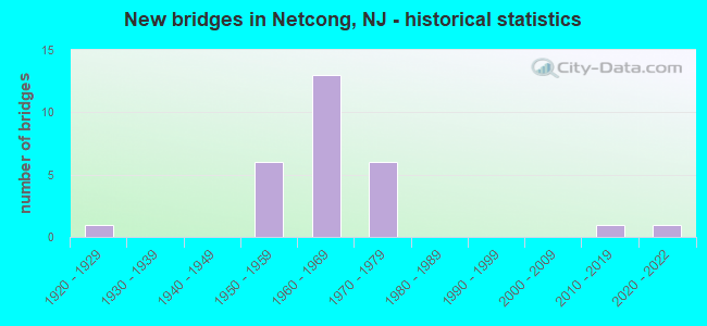
- New bridges - historical statistics
- 11920-1929
- 61950-1959
- 131960-1969
- 61970-1979
- 12010-2019
- 12020-2022

- Reconstructed bridges - Historical Statistics
- 71980-1989
- 01990-1999
- 02000-2009
- 22010-2019


- Bridge Condition - Deck
- 6.7%Excellent
- 13.3%Very good
- 53.3%Good
- 20.0%Satisfactory
- 6.7%Fair

- Bridge Condition - Superstructure
- 6.7%Excellent
- 26.7%Very good
- 20.0%Good
- 40.0%Satisfactory
- 6.7%Fair

- Bridge Condition - Substructure
- 6.7%Excellent
- 33.3%Good
- 40.0%Satisfactory
- 20.0%Fair

- Bridge Condition - Channel
- 80.0%Satisfactory
- 20.0%Fair

- Bridge Condition - Culverts
- 50.0%Good
- 50.0%Satisfactory
Find on map >> Show street view
Structure Number: 140103, Location: 0.24 MI N. OF CR 644 (Lat: 40.900789, Lng: -74.504550), Route carried "on" structure: City street , Year Built: 1970, Status: Open, Structure Length: 3.41m (11.19ft), Average Daily Traffic: 2,963 (year 2021), Truck Traffic: 3%, Average Future Daily Traffic: 3,555 (year 2041), Design Load: HS 20+Mod, Features Intersected: ROCKAWAY RIVER, Facility Carried by Structure: BEACH ST
Minimum Vertical Clearance: 30+ m (98+ ft), Kilometerpoint: 0.821, Lanes on structure: 2, Owner: County Highway Agency, Approaching Roadway Width: 12.2m (40.0ft), Skew: 4 degrees, Material/Design: Steel, Design/Construction: Stringer/Multi-beam, Number Of Spans In Main Unit: 1, Length of Maximum Span: 31.7m (104.0ft), Curb or Sidewalk Widths: Left: 1.5m (4.9ft), Right: 1.5m (4.9ft), Curb-To-Curb Width: 12.2m (40.0ft), Out-to-Out Width: 15.8m (51.8ft)
Condition: Deck: Satisfactory, Superstructure: Satisfactory, Substructure: Satisfactory, Channel: Satisfactory, Inventory Rating: 62.6 metric tons, Method Used To Determine Inventory Rating: Load Factor (LF), Structural Evaluation: Equal to present minimum criteria, Deck Geometry: Equal to present minimum criteria, Waterway Adequacy: Equal to present desirable criteria, Approach Roadway Alignment: Equal to present desirable criteria, Designated Inspection Frequency: Every 24 months, Inspection Date: August 2021, Deck Structure Type: Concrete Cast-file-Place, Wearing Surface/Protective System: Wearing Surface: Monolithic Concrete
Find on map >> Show street view
Structure Number: 1401038, Location: 0.3 MI NORTH OF MAIN ST (Lat: 40.902361, Lng: -74.714311), Route carried "on" structure: City street , Year Built: 2020, Status: Open, Structure Length: 1.37m (4.49ft), Average Daily Traffic: 1,105 (year 2021), Truck Traffic: 1%, Average Future Daily Traffic: 1,348 (year 2041), Design Load: HL 93, Features Intersected: MUSCONETCONG RIVER, Facility Carried by Structure: WATERLOO ROAD
Minimum Vertical Clearance: 30+ m (98+ ft), Kilometerpoint: 0.000, Lanes on structure: 2, Owner: County Highway Agency, Approaching Roadway Width: 7.9m (25.9ft), Skew: 3 degrees, Material/Design: Prestressed concrete, Design/Construction: Box Beam or Girders - Multiple, Number Of Spans In Main Unit: 1, Length of Maximum Span: 12.2m (40.0ft), Curb or Sidewalk Widths: Left: 0.5m (1.6ft), Right: 1.6m (5.2ft), Curb-To-Curb Width: 7.9m (25.9ft), Out-to-Out Width: 11.2m (36.7ft)
Condition: Deck: Excellent, Superstructure: Excellent, Substructure: Excellent, Channel: Satisfactory, Operating Rating: 64.5 metric tons, Method Used To Determine Operating Rating: Load and Resistance Factor Rating (LRFR) rating reported by rating factor(RF) method using HL-93 loadings, Inventory Rating: 49.9 metric tons, Method Used To Determine Inventory Rating: Load and Resistance Factor Rating (LRFR) rating reported by rating factor(RF) method using HL-93 loadings, Structural Evaluation: Superior to present desirable criteria, Deck Geometry: Meets minimum limits, Waterway Adequacy: Superior to present desirable criteria, Approach Roadway Alignment: Equal to present desirable criteria, Length Of Structure Improvement: 1.92m (6.30ft), Designated Inspection Frequency: Every 24 months, Inspection Date: June 2021, Bridge Improvement Cost: $952,000, Roadway Improvement Cost: $95,000, Total Project Cost: $1,424,000 ( Estimate for 2017), Deck Structure Type: Concrete Cast-file-Place, Wearing Surface/Protective System: Wearing Surface: Monolithic Concrete, Deck Protection: Epoxy Coated Reinforcing
Find on map >> Show street view
Structure Number: 1412151, Location: 0.95 W OF NETCONG RD (Lat: 40.890281, Lng: -74.698100), Route carried "on" structure: Interstate 80, Year Built: 1959, Year Reconstructed: 1986, Status: Open, Structure Length: 1.77m (5.81ft), Average Daily Traffic: 48,303 (year 2021), Truck Traffic: 9%, Average Future Daily Traffic: 57,963 (year 2041), Design Load: HS 20, Features Intersected: NJ 183 SOUTHBOUND
Minimum Vertical Clearance: 30+ m (98+ ft), Kilometerpoint: 43.758, Lanes on structure: 4, Lanes under structure: 3, Base Highway Network: Yes, Owner: State Highway Agency, Approaching Roadway Width: 16.8m (55.1ft), Material/Design: Prestressed concrete, Design/Construction: Stringer/Multi-beam, Number Of Spans In Main Unit: 1, Length of Maximum Span: 15.8m (51.8ft), Curb-To-Curb Width: 16.8m (55.1ft), Out-to-Out Width: 17.8m (58.4ft)
Condition: Deck: Good, Superstructure: Satisfactory, Substructure: Satisfactory, Operating Rating: 49.0 metric tons, Method Used To Determine Operating Rating: Load Factor (LF), Inventory Rating: 29.0 metric tons, Method Used To Determine Inventory Rating: Load Factor (LF), Structural Evaluation: Equal to present minimum criteria, Deck Geometry: High priority of replacement, Underclear: Equal to present minimum criteria, Approach Roadway Alignment: Equal to present desirable criteria, Length Of Structure Improvement: 1.77m (5.81ft), Designated Inspection Frequency: Every 24 months, Inspection Date: April 2021, Bridge Improvement Cost: $23,000, Roadway Improvement Cost: $48,000, Total Project Cost: $101,000 ( Estimate for 2021), Deck Structure Type: Concrete Cast-file-Place, Wearing Surface/Protective System: Wearing Surface: Bituminous, Deck Protection: Epoxy Coated Reinforcing
Find on map >> Show street view
Structure Number: 1412152, Location: AT I-80 EXIT 27 (Lat: 40.890700, Lng: -74.697950), Route carried "on" structure: Interstate 80, Year Built: 1960, Year Reconstructed: 1986, Status: Open, Structure Length: 1.74m (5.71ft), Average Daily Traffic: 48,303 (year 2021), Truck Traffic: 9%, Average Future Daily Traffic: 57,964 (year 2041), Design Load: HS 20, Features Intersected: NJ 183 SOUTHBOUND
Minimum Vertical Clearance: 30+ m (98+ ft), Kilometerpoint: 43.758, Lanes on structure: 4, Lanes under structure: 3, Base Highway Network: Yes, Owner: State Highway Agency, Approaching Roadway Width: 16.2m (53.1ft), Material/Design: Prestressed concrete, Design/Construction: Stringer/Multi-beam, Number Of Spans In Main Unit: 1, Length of Maximum Span: 15.5m (50.9ft), Curb-To-Curb Width: 16.8m (55.1ft), Out-to-Out Width: 17.8m (58.4ft)
Condition: Deck: Good, Superstructure: Good, Substructure: Satisfactory, Operating Rating: 49.0 metric tons, Method Used To Determine Operating Rating: Load Factor (LF), Inventory Rating: 29.0 metric tons, Method Used To Determine Inventory Rating: Load Factor (LF), Structural Evaluation: Equal to present minimum criteria, Deck Geometry: High priority of replacement, Underclear: Equal to present minimum criteria, Approach Roadway Alignment: Equal to present desirable criteria, Length Of Structure Improvement: 1.74m (5.71ft), Designated Inspection Frequency: Every 24 months, Inspection Date: May 2021, Bridge Improvement Cost: $36,000, Roadway Improvement Cost: $66,000, Total Project Cost: $157,000 ( Estimate for 2021), Deck Structure Type: Concrete Cast-file-Place, Wearing Surface/Protective System: Wearing Surface: Bituminous, Deck Protection: Epoxy Coated Reinforcing
Find on map >> Show street view
Structure Number: 1412154, Location: AT I-80 EXIT 27 (Lat: 40.890269, Lng: -74.696839), Route carried "on" structure: Interstate 80, Year Built: 1960, Year Reconstructed: 1986, Status: Open, Structure Length: 1.80m (5.91ft), Average Daily Traffic: 39,200 (year 2021), Truck Traffic: 9%, Average Future Daily Traffic: 47,100 (year 2041), Design Load: HS 20, Features Intersected: US 206 NORTHBOUND
Minimum Vertical Clearance: 30+ m (98+ ft), Kilometerpoint: 43.855, Lanes on structure: 4, Lanes under structure: 2, Base Highway Network: Yes, Owner: State Highway Agency, Approaching Roadway Width: 16.8m (55.1ft), Material/Design: Prestressed concrete, Design/Construction: Stringer/Multi-beam, Number Of Spans In Main Unit: 1, Length of Maximum Span: 16.5m (54.1ft), Curb-To-Curb Width: 16.8m (55.1ft), Out-to-Out Width: 17.8m (58.4ft)
Condition: Deck: Good, Superstructure: Satisfactory, Substructure: Satisfactory, Operating Rating: 70.8 metric tons, Method Used To Determine Operating Rating: Load Factor (LF), Inventory Rating: 42.6 metric tons, Method Used To Determine Inventory Rating: Load Factor (LF), Structural Evaluation: Equal to present minimum criteria, Deck Geometry: High priority of replacement, Underclear: Meets minimum limits, Approach Roadway Alignment: Equal to present desirable criteria, Length Of Structure Improvement: 1.80m (5.91ft), Designated Inspection Frequency: Every 24 months, Inspection Date: August 2021, Bridge Improvement Cost: $307,000, Roadway Improvement Cost: $50,000, Total Project Cost: $538,000 ( Estimate for 2021), Deck Structure Type: Concrete Cast-file-Place, Wearing Surface/Protective System: Wearing Surface: Bituminous, Deck Protection: Epoxy Coated Reinforcing
Find on map >> Show street view
Structure Number: 1412155, Location: I-80 EXIT-27 (Lat: 40.890531, Lng: -74.696889), Route carried "on" structure: Interstate 80, Year Built: 1960, Year Reconstructed: 1986, Status: Open, Structure Length: 1.98m (6.50ft), Average Daily Traffic: 39,200 (year 2021), Truck Traffic: 9%, Average Future Daily Traffic: 47,100 (year 2021), Design Load: HS 20, Features Intersected: US 206 NB & NJ 183 NB
Minimum Vertical Clearance: 30+ m (98+ ft), Kilometerpoint: 43.855, Lanes on structure: 4, Lanes under structure: 3, Base Highway Network: Yes, Owner: State Highway Agency, Approaching Roadway Width: 16.8m (55.1ft), Skew: 1 degrees, Material/Design: Prestressed concrete, Design/Construction: Stringer/Multi-beam, Number Of Spans In Main Unit: 1, Length of Maximum Span: 18.6m (61.0ft), Curb-To-Curb Width: 16.8m (55.1ft), Out-to-Out Width: 17.8m (58.4ft)
Condition: Deck: Good, Superstructure: Satisfactory, Substructure: Good, Operating Rating: 76.2 metric tons, Method Used To Determine Operating Rating: Load Factor (LF), Inventory Rating: 44.5 metric tons, Method Used To Determine Inventory Rating: Load Factor (LF), Structural Evaluation: Equal to present minimum criteria, Deck Geometry: High priority of replacement, Underclear: Meets minimum limits, Approach Roadway Alignment: Equal to present desirable criteria, Length Of Structure Improvement: 1.98m (6.50ft), Designated Inspection Frequency: Every 24 months, Inspection Date: August 2021, Bridge Improvement Cost: $338,000, Roadway Improvement Cost: $50,000, Total Project Cost: $583,000 ( Estimate for 2021), Deck Structure Type: Concrete Cast-file-Place, Wearing Surface/Protective System: Wearing Surface: Bituminous, Deck Protection: Epoxy Coated Reinforcing
Find on map >> Show street view
Structure Number: 1412156, Location: .9MI E OF NJ 183 & 206 (Lat: 40.890361, Lng: -74.679689), Route carried "on" structure: Interstate 80, Year Built: 1958, Year Reconstructed: 2019, Status: Open, Structure Length: 4.45m (14.60ft), Average Daily Traffic: 48,300 (year 2021), Truck Traffic: 9%, Average Future Daily Traffic: 58,000 (year 2041), Design Load: HL 93, Features Intersected: US 46 (LEDGEWOOD AVE.)
Minimum Vertical Clearance: 30+ m (98+ ft), Kilometerpoint: 45.303, Lanes on structure: 3, Lanes under structure: 4, Base Highway Network: Yes, Owner: State Highway Agency, Approaching Roadway Width: 16.3m (53.5ft), Skew: 4 degrees, Material/Design: Steel, Design/Construction: Stringer/Multi-beam, Number Of Spans In Main Unit: 1, Length of Maximum Span: 43.0m (141.1ft), Curb-To-Curb Width: 16.3m (53.5ft), Out-to-Out Width: 17.3m (56.8ft)
Condition: Deck: Very good, Superstructure: Very good, Substructure: Good, Operating Rating: 83.3 metric tons, Method Used To Determine Operating Rating: Load and Resistance Factor Rating (LRFR) rating reported by rating factor(RF) method using HL-93 loadings, Inventory Rating: 64.2 metric tons, Method Used To Determine Inventory Rating: Load and Resistance Factor Rating (LRFR) rating reported by rating factor(RF) method using HL-93 loadings, Structural Evaluation: Better than present minimum criteria, Deck Geometry: Equal to present minimum criteria, Underclear: Equal to present minimum criteria, Approach Roadway Alignment: Equal to present desirable criteria, Designated Inspection Frequency: Every 24 months, Inspection Date: September 2021, Bridge Improvement Cost: $3,178,000, Roadway Improvement Cost: $575,000, Total Project Cost: $5,733,000 ( Estimate for 2017), Deck Structure Type: Concrete Cast-file-Place, Wearing Surface/Protective System: Deck Protection: Epoxy Coated Reinforcing
Find on map >> Show street view
Structure Number: 1412157, Location: 0.9 MI E OF I-80 EXIT 27 (Lat: 40.890539, Lng: -74.680081), Route carried "on" structure: Interstate 80, Year Built: 1960, Year Reconstructed: 2019, Status: Open, Structure Length: 4.57m (14.99ft), Average Daily Traffic: 48,300 (year 2021), Truck Traffic: 9%, Average Future Daily Traffic: 58,000 (year 2041), Design Load: HL 93, Features Intersected: US 46 (LEDGEWOOD AVE.)
Minimum Vertical Clearance: 30+ m (98+ ft), Kilometerpoint: 45.303, Lanes on structure: 3, Lanes under structure: 4, Base Highway Network: Yes, Owner: State Highway Agency, Approaching Roadway Width: 16.3m (53.5ft), Skew: 4 degrees, Material/Design: Steel, Design/Construction: Stringer/Multi-beam, Number Of Spans In Main Unit: 1, Length of Maximum Span: 43.0m (141.1ft), Curb-To-Curb Width: 16.3m (53.5ft), Out-to-Out Width: 17.3m (56.8ft)
Condition: Deck: Very good, Superstructure: Very good, Substructure: Good, Operating Rating: 83.3 metric tons, Method Used To Determine Operating Rating: Load and Resistance Factor Rating (LRFR) rating reported by rating factor(RF) method using HL-93 loadings, Inventory Rating: 64.2 metric tons, Method Used To Determine Inventory Rating: Load and Resistance Factor Rating (LRFR) rating reported by rating factor(RF) method using HL-93 loadings, Structural Evaluation: Better than present minimum criteria, Deck Geometry: Equal to present minimum criteria, Underclear: Equal to present minimum criteria, Approach Roadway Alignment: Equal to present desirable criteria, Designated Inspection Frequency: Every 24 months, Inspection Date: September 2021, Bridge Improvement Cost: $3,199,000, Roadway Improvement Cost: $579,000, Total Project Cost: $5,768,000 ( Estimate for 2017), Deck Structure Type: Concrete Cast-file-Place, Wearing Surface/Protective System: Deck Protection: Epoxy Coated Reinforcing
Find on map >> Show street view
Structure Number: 1417161, Location: AT I-80 EXIT 27 (Lat: 40.891900, Lng: -74.698139), Route carried "on" structure: US 206, Year Built: 1960, Year Reconstructed: 1986, Status: Open, Structure Length: 1.52m (4.99ft), Average Daily Traffic: 10,400 (year 2020), Truck Traffic: 4%, Average Future Daily Traffic: 12,500 (year 2040), Design Load: HS 20+Mod, Features Intersected: NJ 183 SB
Minimum Vertical Clearance: 30+ m (98+ ft), Kilometerpoint: 153.451, Lanes on structure: 1, Lanes under structure: 2, Base Highway Network: Yes, Owner: State Highway Agency, Approaching Roadway Width: 8.1m (26.6ft), Skew: 2 degrees, Material/Design: Prestressed concrete, Design/Construction: Stringer/Multi-beam, Number Of Spans In Main Unit: 1, Length of Maximum Span: 13.4m (44.0ft), Curb or Sidewalk Widths: Left: 0.5m (1.6ft), Right: 0.5m (1.6ft), Curb-To-Curb Width: 8.1m (26.6ft), Out-to-Out Width: 9.8m (32.2ft)
Condition: Deck: Good, Superstructure: Very good, Substructure: Satisfactory, Operating Rating: 68.0 metric tons, Method Used To Determine Operating Rating: Load Factor (LF), Inventory Rating: 40.8 metric tons, Method Used To Determine Inventory Rating: Load Factor (LF), Structural Evaluation: Equal to present minimum criteria, Deck Geometry: High priority of replacement, Underclear: Meets minimum limits, Approach Roadway Alignment: Better than present minimum criteria, Length Of Structure Improvement: 1.52m (4.99ft), Designated Inspection Frequency: Every 24 months, Inspection Date: June 2020, Bridge Improvement Cost: $300,000, Roadway Improvement Cost: $50,000, Total Project Cost: $480,000 ( Estimate for 2020), Deck Structure Type: Concrete Cast-file-Place, Wearing Surface/Protective System: Wearing Surface: Latex Concrete
Find on map >> Show street view
Structure Number: 142615, Location: 0.04 MILE NORTH OF US 46 (Lat: 40.897619, Lng: -74.702061), Route carried "on" structure: State highway 183, Year Built: 2013, Status: Open, Structure Length: 1.98m (6.50ft), Average Daily Traffic: 19,740 (year 2019), Truck Traffic: 4%, Average Future Daily Traffic: 24,080 (year 2039), Design Load: HL 93, Features Intersected: NJ TRANSIT(MORR LINE)
Minimum Vertical Clearance: 30+ m (98+ ft), Kilometerpoint: 0.966, Lanes on structure: 3, Base Highway Network: Yes, Owner: State Highway Agency, Approaching Roadway Width: 18.0m (59.1ft), Skew: 21 degrees, Material/Design: Steel, Design/Construction: Stringer/Multi-beam, Number Of Spans In Main Unit: 1, Length of Maximum Span: 18.9m (62.0ft), Curb or Sidewalk Widths: Left: 3.0m (9.8ft), Right: 3.0m (9.8ft), Curb-To-Curb Width: 18.2m (59.7ft), Out-to-Out Width: 26.3m (86.3ft)
Condition: Deck: Good, Superstructure: Very good, Substructure: Good, Operating Rating: 96.9 metric tons, Method Used To Determine Operating Rating: Load and Resistance Factor Rating (LRFR) rating reported by rating factor(RF) method using HL-93 loadings, Inventory Rating: 96.9 metric tons, Method Used To Determine Inventory Rating: Load and Resistance Factor Rating (LRFR) rating reported by rating factor(RF) method using HL-93 loadings, Structural Evaluation: Better than present minimum criteria, Deck Geometry: Superior to present desirable criteria, Underclear: Superior to present desirable criteria, Approach Roadway Alignment: Better than present minimum criteria, Designated Inspection Frequency: Every 24 months, Inspection Date: March 2021, Deck Structure Type: Concrete Cast-file-Place, Wearing Surface/Protective System: Wearing Surface: Monolithic Concrete
Find on map >> Show street view
Structure Number: 1426151, Location: 0.40 MI NORTH OF US 46 (Lat: 40.901850, Lng: -74.704789), Route carried "on" structure: State highway 183, Year Built: 1926, Status: Open, Structure Length: 0.85m (2.79ft), Average Daily Traffic: 20,060 (year 2021), Truck Traffic: 4%, Average Future Daily Traffic: 24,478 (year 2041), Features Intersected: MUSCONETCONG LAKE OUTLET
Minimum Vertical Clearance: 30+ m (98+ ft), Kilometerpoint: 1.545, Lanes on structure: 2, Base Highway Network: Yes, Owner: State Highway Agency, Approaching Roadway Width: 12.2m (40.0ft), Material/Design: Concrete, Design/Construction: Tee Beam, Number Of Spans In Main Unit: 1, Length of Maximum Span: 7.3m (24.0ft), Curb or Sidewalk Widths: Left: 2.4m (7.9ft), Right: 3.0m (9.8ft), Curb-To-Curb Width: 12.3m (40.4ft), Out-to-Out Width: 19.2m (63.0ft)
Condition: Deck: Fair, Superstructure: Satisfactory, Substructure: Fair, Channel: Satisfactory, Operating Rating: 44.5 metric tons, Method Used To Determine Operating Rating: Field evaluation and documented engineering judgment, Inventory Rating: 32.7 metric tons, Method Used To Determine Inventory Rating: Field evaluation and documented engineering judgment, Structural Evaluation: Somewhat better than minimum adequacy, Deck Geometry: Somewhat better than minimum adequacy, Waterway Adequacy: Superior to present desirable criteria, Approach Roadway Alignment: Equal to present desirable criteria, Designated Inspection Frequency: Every 24 months, Inspection Date: March 2021, Deck Structure Type: Concrete Cast-file-Place, Wearing Surface/Protective System: Wearing Surface: Bituminous
Find on map >> Show street view
Structure Number: 142715, Location: 0.2 MI WEST OF RTE 206 (Lat: 40.907631, Lng: -74.727811), Route carried "on" structure: City street , Year Built: 1970, Status: Open, Structure Length: 6.71m (22.01ft), Average Daily Traffic: 7,405 (year 2021), Truck Traffic: 1%, Average Future Daily Traffic: 8,885 (year 2041), Design Load: HS 20, Features Intersected: I-80, Facility Carried by Structure: International Dr
Minimum Vertical Clearance: 30+ m (98+ ft), Kilometerpoint: 8.240, Lanes on structure: 2, Lanes under structure: 7, Owner: State Highway Agency, Approaching Roadway Width: 11.3m (37.1ft), Skew: 2 degrees, Material/Design: Steel, Design/Construction: Stringer/Multi-beam, Number Of Spans In Main Unit: 2, Length of Maximum Span: 32.3m (106.0ft), Curb or Sidewalk Widths: Left: 0.5m (1.6ft), Right: 1.8m (5.9ft), Curb-To-Curb Width: 9.1m (29.9ft), Out-to-Out Width: 12.0m (39.4ft)
Condition: Deck: Satisfactory, Superstructure: Fair, Substructure: Satisfactory, Operating Rating: 88.9 metric tons, Method Used To Determine Operating Rating: Load Factor (LF), Inventory Rating: 53.5 metric tons, Method Used To Determine Inventory Rating: Load Factor (LF), Structural Evaluation: Somewhat better than minimum adequacy, Deck Geometry: Meets minimum limits, Underclear: Meets minimum limits, Approach Roadway Alignment: Equal to present desirable criteria, Designated Inspection Frequency: Every 24 months, Inspection Date: July 2021, Deck Structure Type: Concrete Cast-file-Place, Wearing Surface/Protective System: Wearing Surface: Latex Concrete
Find on map >> Show street view
Structure Number: 1427151, Location: 0.1 MI NORTH OF RTE I-80 (Lat: 40.908431, Lng: -74.726200), Route carried "on" structure: Other road , Year Built: 1969, Status: Open, Structure Length: 0.64m (2.10ft), Average Daily Traffic: 7,575 (year 2020), Truck Traffic: 3%, Average Future Daily Traffic: 9,739 (year 2040), Design Load: HS 20, Features Intersected: WILLS BROOK, Facility Carried by Structure: INTERNATIONAL DR
Minimum Vertical Clearance: 30+ m (98+ ft), Kilometerpoint: 8.369, Lanes on structure: 3, Owner: State Highway Agency, Approaching Roadway Width: 12.2m (40.0ft), Material/Design: Concrete, Design/Construction: Culvert, Number Of Spans In Main Unit: 2, Length of Maximum Span: 3.4m (11.2ft)
Condition: Channel: Fair, Culverts: Good, Structural Evaluation: Better than present minimum criteria, Waterway Adequacy: Equal to present desirable criteria, Approach Roadway Alignment: Equal to present desirable criteria, Designated Inspection Frequency: Every 24 months, Inspection Date: June 2020
Find on map >> Show street view
Structure Number: 1427152, Location: 300 Ft. West of RT 206 (Lat: 40.906319, Lng: -74.725631), Route carried "on" structure: Interstate 80, Year Built: 1969, Status: Open, Structure Length: 0.70m (2.30ft), Average Daily Traffic: 63,810 (year 2020), Truck Traffic: 9%, Average Future Daily Traffic: 77,848 (year 2040), Design Load: HS 20, Features Intersected: WILLIS BROOK
Minimum Vertical Clearance: 30+ m (98+ ft), Kilometerpoint: 40.539, Lanes on structure: 7, Base Highway Network: Yes, Owner: State Highway Agency, Approaching Roadway Width: 39.6m (129.9ft), Skew: 21 degrees, Material/Design: Concrete, Design/Construction: Culvert, Number Of Spans In Main Unit: 2, Length of Maximum Span: 3.4m (11.2ft)
Condition: Channel: Satisfactory, Culverts: Satisfactory, Operating Rating: 54.4 metric tons, Method Used To Determine Operating Rating: Field evaluation and documented engineering judgment, Inventory Rating: 32.7 metric tons, Method Used To Determine Inventory Rating: Field evaluation and documented engineering judgment, Structural Evaluation: Equal to present minimum criteria, Waterway Adequacy: Better than present minimum criteria, Approach Roadway Alignment: Better than present minimum criteria, Designated Inspection Frequency: Every 24 months, Inspection Date: March 2020
Find on map >> Show street view
Structure Number: 143115, Location: 0.94 MI S OF EXIT 27 (Lat: 40.893769, Lng: -74.715600), Route carried "on" structure: Interstate 80, Year Built: 1970, Status: Open, Structure Length: 15.12m (49.61ft), Average Daily Traffic: 41,730 (year 2021), Truck Traffic: 9%, Average Future Daily Traffic: 50,076 (year 2041), Design Load: HS 20, Features Intersected: US 46 & MORRSITOWN LINE
Minimum Vertical Clearance: 30+ m (98+ ft), Kilometerpoint: 42.245, Lanes on structure: 3, Lanes under structure: 4, Base Highway Network: Yes, Owner: State Highway Agency, Approaching Roadway Width: 15.8m (51.8ft), Skew: 1 degrees, Material/Design: Steel, Design/Construction: Stringer/Multi-beam, Number Of Spans In Main Unit: 5, Length of Maximum Span: 31.4m (103.0ft), Curb or Sidewalk Widths: Left: 0.2m (0.7ft), Right: 0.0m, Curb-To-Curb Width: 16.0m (52.5ft), Out-to-Out Width: 17.4m (57.1ft)
Condition: Deck: Satisfactory, Superstructure: Good, Substructure: Fair, Operating Rating: 78.9 metric tons, Method Used To Determine Operating Rating: Load Factor (LF), Inventory Rating: 47.2 metric tons, Method Used To Determine Inventory Rating: Load Factor (LF), Structural Evaluation: Somewhat better than minimum adequacy, Deck Geometry: Equal to present minimum criteria, Underclear: Somewhat better than minimum adequacy, Approach Roadway Alignment: Better than present minimum criteria, Designated Inspection Frequency: Every 24 months, Inspection Date: April 2021, Deck Structure Type: Concrete Cast-file-Place, Wearing Surface/Protective System: Wearing Surface: Bituminous
Find on map >> Show street view
Structure Number: 1431151, Location: 1.0 MILE EAST OF RT 206 (Lat: 40.893931, Lng: -74.715281), Route carried "on" structure: Interstate 80, Year Built: 1970, Year Reconstructed: 1985, Status: Open, Structure Length: 15.21m (49.90ft), Average Daily Traffic: 41,730 (year 2021), Truck Traffic: 9%, Average Future Daily Traffic: 50,076 (year 2041), Design Load: HS 20+Mod, Features Intersected: US 46 & NJ Transit
Minimum Vertical Clearance: 30+ m (98+ ft), Kilometerpoint: 42.181, Lanes on structure: 3, Lanes under structure: 4, Base Highway Network: Yes, Owner: State Highway Agency, Approaching Roadway Width: 16.1m (52.8ft), Skew: 1 degrees, Material/Design: Steel, Design/Construction: Stringer/Multi-beam, Number Of Spans In Main Unit: 5, Length of Maximum Span: 31.4m (103.0ft), Curb-To-Curb Width: 16.1m (52.8ft), Out-to-Out Width: 17.1m (56.1ft)
Condition: Deck: Good, Superstructure: Good, Substructure: Fair, Operating Rating: 75.3 metric tons, Method Used To Determine Operating Rating: Load Factor (LF), Inventory Rating: 45.4 metric tons, Method Used To Determine Inventory Rating: Load Factor (LF), Structural Evaluation: Somewhat better than minimum adequacy, Deck Geometry: Equal to present minimum criteria, Underclear: Equal to present minimum criteria, Approach Roadway Alignment: Equal to present desirable criteria, Designated Inspection Frequency: Every 24 months, Inspection Date: April 2021, Deck Structure Type: Concrete Cast-file-Place, Wearing Surface/Protective System: Wearing Surface: Bituminous
Find on map >> Show street view
Structure Number: 1431152, Location: 0.04 MILES EAST OF EL RR (Lat: 40.893761, Lng: -74.713031), Route carried "on" structure: Ramp Interstate 80, Year Built: 1959, Year Reconstructed: 1986, Status: Open, Structure Length: 1.55m (5.09ft), Average Daily Traffic: 11,229 (year 2021), Truck Traffic: 9%, Average Future Daily Traffic: 13,702 (year 2041), Design Load: HS 20, Features Intersected: ROUTE U.S. 46 E.B.
Minimum Vertical Clearance: 30+ m (98+ ft), Kilometerpoint: 42.245, Lanes on structure: 1, Lanes under structure: 2, Owner: State Highway Agency, Approaching Roadway Width: 9.1m (29.9ft), Skew: 2 degrees, Material/Design: Prestressed concrete, Design/Construction: Stringer/Multi-beam, Number Of Spans In Main Unit: 1, Length of Maximum Span: 13.4m (44.0ft), Curb-To-Curb Width: 9.2m (30.2ft), Out-to-Out Width: 10.3m (33.8ft)
Condition: Deck: Good, Superstructure: Satisfactory, Substructure: Good, Operating Rating: 54.4 metric tons, Method Used To Determine Operating Rating: Field evaluation and documented engineering judgment, Inventory Rating: 32.7 metric tons, Method Used To Determine Inventory Rating: Field evaluation and documented engineering judgment, Structural Evaluation: Equal to present minimum criteria, Deck Geometry: Superior to present desirable criteria, Underclear: Meets minimum limits, Approach Roadway Alignment: Better than present minimum criteria, Designated Inspection Frequency: Every 24 months, Inspection Date: May 2021, Deck Structure Type: Concrete Cast-file-Place, Wearing Surface/Protective System: Wearing Surface: Latex Concrete
Find on map >> Show street view
Structure Number: 1412151, Location: 0.95 W OF NETCONG RD (Lat: 40.890281, Lng: -74.698100), Route carried "under" structure: State highway 183, Year Built: 1959, Structure Length: 0. m, Average Daily Traffic: 7,524 (year 2021), Truck Traffic: 4%, Features Intersected: NJ 183 SOUTHBOUND, Facility Carried by Structure: I-80 EB & RAMP FF
Minimum Vertical Clearance: 4.60m (15.09ft), Kilometerpoint: 0.161, Lanes on structure: 4, Lanes under structure: 3, Material/Design: Prestressed concrete, Design/Construction: Stringer/Multi-beam, Length of Maximum Span: 15.8m (51.8ft)
Find on map >> Show street view
Structure Number: 1412152, Location: AT I-80 EXIT 27 (Lat: 40.890700, Lng: -74.697950), Route carried "under" structure: State highway 183, Year Built: 1960, Structure Length: 0. m, Average Daily Traffic: 7,524 (year 2021), Truck Traffic: 4%, Features Intersected: NJ 183 SOUTHBOUND, Facility Carried by Structure: I-80 WB & RAMP"EE"
Minimum Vertical Clearance: 4.57m (14.99ft), Kilometerpoint: 0.161, Lanes on structure: 4, Lanes under structure: 3, Material/Design: Prestressed concrete, Design/Construction: Stringer/Multi-beam, Length of Maximum Span: 15.5m (50.9ft)
Find on map >> Show street view
Structure Number: 1412154, Location: AT I-80 EXIT 27 (Lat: 40.890269, Lng: -74.696839), Route carried "under" structure: US 206, Year Built: 1960, Structure Length: 0. m, Average Daily Traffic: 4,600 (year 2021), Truck Traffic: 4%, Features Intersected: US 206 NORTHBOUND, Facility Carried by Structure: I-80 EASTBOUND
Minimum Vertical Clearance: 5.16m (16.93ft), Kilometerpoint: 153.226, Lanes on structure: 4, Lanes under structure: 2, Material/Design: Prestressed concrete, Design/Construction: Stringer/Multi-beam, Length of Maximum Span: 16.5m (54.1ft)
Find on map >> Show street view
Structure Number: 1412155, Location: I-80 EXIT-27 (Lat: 40.890531, Lng: -74.696889), Route carried "under" structure: Interstate , Year Built: 1960, Structure Length: 0. m, Average Daily Traffic: 7,530 (year 2021), Truck Traffic: 4%, Features Intersected: US 206 NB & NJ 183 NB, Facility Carried by Structure: I-80 WB
Minimum Vertical Clearance: 4.70m (15.42ft), Kilometerpoint: 0.161, Lanes on structure: 4, Lanes under structure: 2, Material/Design: Prestressed concrete, Design/Construction: Stringer/Multi-beam, Length of Maximum Span: 18.6m (61.0ft)
Find on map >> Show street view
Structure Number: 1412155, Location: I-80 EXIT-27 (Lat: 40.890531, Lng: -74.696889), Route carried "under" structure: US 206, Year Built: 1960, Structure Length: 0. m, Average Daily Traffic: 4,600 (year 2021), Truck Traffic: 4%, Features Intersected: US 206 NB & NJ 183 NB, Facility Carried by Structure: I-80 WB
Minimum Vertical Clearance: 4.88m (16.01ft), Kilometerpoint: 153.226, Lanes on structure: 4, Lanes under structure: 1, Material/Design: Prestressed concrete, Design/Construction: Stringer/Multi-beam, Length of Maximum Span: 18.6m (61.0ft)
Find on map >> Show street view
Structure Number: 1412156, Location: .9MI E OF NJ 183 & 206 (Lat: 40.890361, Lng: -74.679689), Route carried "under" structure: US 46, Year Built: 1958, Structure Length: 0. m, Average Daily Traffic: 13,500 (year 2021), Truck Traffic: 4%, Features Intersected: US 46 (LEDGEWOOD AVE.), Facility Carried by Structure: I-80 EB
Minimum Vertical Clearance: 4.69m (15.39ft), Kilometerpoint: 50.694, Lanes on structure: 3, Lanes under structure: 4, Material/Design: Steel, Design/Construction: Stringer/Multi-beam, Length of Maximum Span: 43.0m (141.1ft)
Find on map >> Show street view
Structure Number: 1412157, Location: 0.9 MI E OF I-80 EXIT 27 (Lat: 40.890539, Lng: -74.680081), Route carried "under" structure: US 46, Year Built: 1960, Structure Length: 0. m, Average Daily Traffic: 13,500 (year 2021), Truck Traffic: 4%, Features Intersected: US 46 (LEDGEWOOD AVE.), Facility Carried by Structure: I-80 WB
Minimum Vertical Clearance: 4.72m (15.49ft), Kilometerpoint: 50.694, Lanes on structure: 3, Lanes under structure: 4, Material/Design: Steel, Design/Construction: Stringer/Multi-beam, Length of Maximum Span: 43.0m (141.1ft)
Find on map >> Show street view
Structure Number: 1417161, Location: AT I-80 EXIT 27 (Lat: 40.891900, Lng: -74.698139), Route carried "under" structure: State highway 183, Year Built: 1960, Structure Length: 0. m, Average Daily Traffic: 7,450 (year 2020), Truck Traffic: 4%, Features Intersected: NJ 183 SB, Facility Carried by Structure: US 206 NB
Minimum Vertical Clearance: 4.57m (14.99ft), Kilometerpoint: 0.016, Lanes on structure: 1, Lanes under structure: 2, Material/Design: Prestressed concrete, Design/Construction: Stringer/Multi-beam, Length of Maximum Span: 13.4m (44.0ft)
Find on map >> Show street view
Structure Number: 143115, Location: 0.94 MI S OF EXIT 27 (Lat: 40.893769, Lng: -74.715600), Route carried "under" structure: US 46, Year Built: 1970, Structure Length: 0. m, Average Daily Traffic: 11,039 (year 2021), Truck Traffic: 4%, Features Intersected: US 46 & MORRSITOWN LINE, Facility Carried by Structure: I-80 EB
Minimum Vertical Clearance: 8.38m (27.49ft), Kilometerpoint: 47.395, Lanes on structure: 3, Lanes under structure: 4, Material/Design: Steel, Design/Construction: Stringer/Multi-beam, Length of Maximum Span: 31.4m (103.0ft)
Find on map >> Show street view
Structure Number: 1431151, Location: 1.0 MILE EAST OF RT 206 (Lat: 40.893931, Lng: -74.715281), Route carried "under" structure: US 46, Year Built: 1970, Structure Length: 0. m, Average Daily Traffic: 11,040 (year 2021), Truck Traffic: 4%, Features Intersected: US 46 & NJ Transit, Facility Carried by Structure: Route I-80 WB
Minimum Vertical Clearance: 7.26m (23.82ft), Kilometerpoint: 47.427, Lanes on structure: 3, Lanes under structure: 4, Material/Design: Steel, Design/Construction: Stringer/Multi-beam, Length of Maximum Span: 31.4m (103.0ft)
Find on map >> Show street view
Structure Number: 1431152, Location: 0.04 MILES EAST OF EL RR (Lat: 40.893761, Lng: -74.713031), Route carried "under" structure: US 46, Year Built: 1959, Structure Length: 0. m, Average Daily Traffic: 19,155 (year 2019), Truck Traffic: 4%, Features Intersected: ROUTE U.S. 46 E.B., Facility Carried by Structure: I80 RAMP Y
Minimum Vertical Clearance: 4.32m (14.17ft), Kilometerpoint: 47.524, Lanes on structure: 1, Lanes under structure: 2, Material/Design: Prestressed concrete, Design/Construction: Stringer/Multi-beam, Length of Maximum Span: 13.4m (44.0ft)