Bridge Statistics for Nether Providence Township, Pennsylvania (PA)
Condition, Traffic, Stress, Structural Evaluation, Project Costs
- National Bridge Inventory (NBI) Statistics
- 29Number of bridges
- 512ft / 156mTotal length
- $1,206,000Total costs
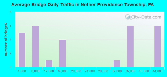
- 608,181Total average daily traffic
- 51,287Total average daily truck traffic
- National Bridge Inventory (NBI) Registered Bridges for Nether Providence Township
- No street view available for this location
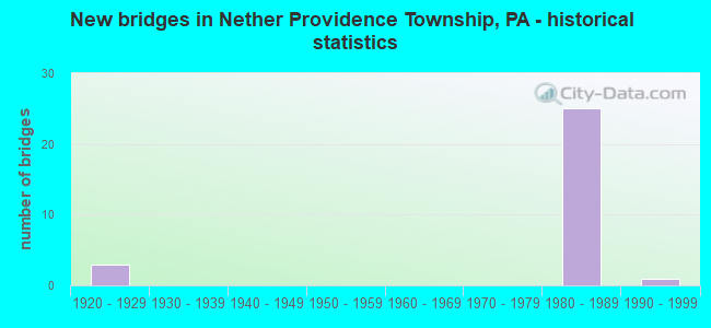
- New bridges - historical statistics
- 31920-1929
- 251980-1989
- 11990-1999
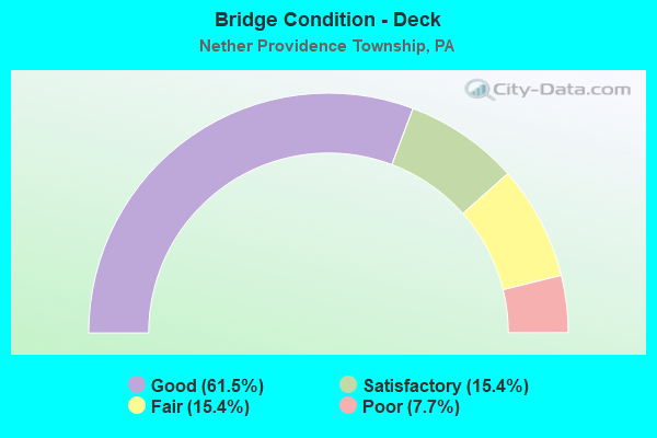
- Bridge Condition - Deck
- 61.5%Good
- 15.4%Satisfactory
- 15.4%Fair
- 7.7%Poor
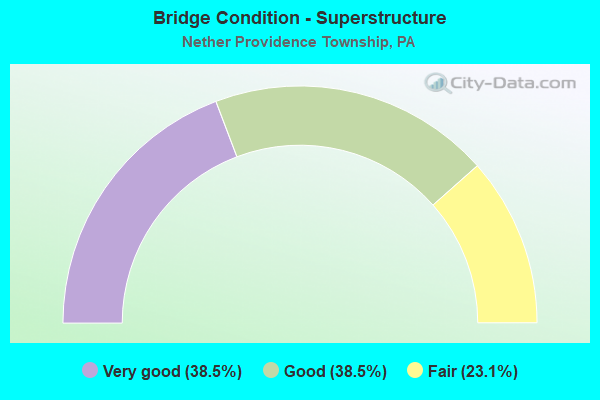
- Bridge Condition - Superstructure
- 38.5%Very good
- 38.5%Good
- 23.1%Fair
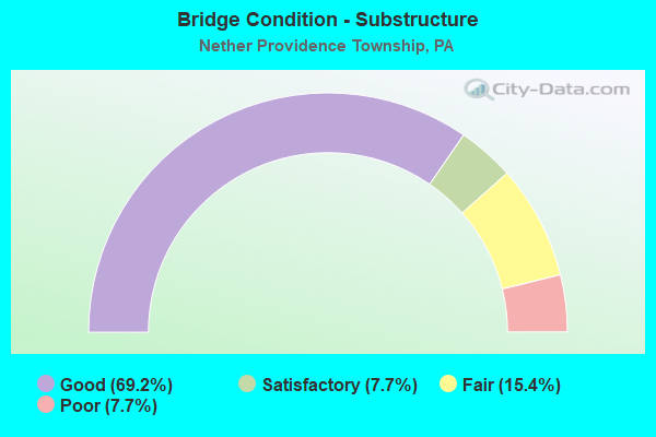
- Bridge Condition - Substructure
- 69.2%Good
- 7.7%Satisfactory
- 15.4%Fair
- 7.7%Poor
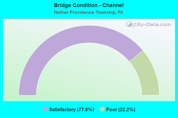
- Bridge Condition - Channel
- 77.8%Satisfactory
- 22.2%Poor
Find on map >> Show street view
Structure Number: 14948, Location: 2MI.NORTH PA.320 34E08 (Lat: 39.903761, Lng: -75.375008), Route carried "on" structure: State highway 252, Year Built: 1928, Status: Open, Structure Length: 1.10m (3.61ft), Average Daily Traffic: 8,878 (year 2022), Truck Traffic: 5%, Average Future Daily Traffic: 13,101 (year 2032), Design Load: H 20, Features Intersected: SEPTA (WEST CHESTER R3), Facility Carried by Structure: PROVIDENCE ROAD
Minimum Vertical Clearance: 30+ m (98+ ft), Kilometerpoint: 2.974, Lanes on structure: 2, Base Highway Network: Yes, Owner: State Highway Agency, Approaching Roadway Width: 7.9m (25.9ft), Skew: 1 degrees, Material/Design: Steel, Design/Construction: Stringer/Multi-beam, Number Of Spans In Main Unit: 1, Length of Maximum Span: 10.7m (35.1ft), Curb or Sidewalk Widths: Left: 1.5m (4.9ft), Right: 1.5m (4.9ft), Curb-To-Curb Width: 9.1m (29.9ft), Out-to-Out Width: 14.6m (47.9ft)
Condition: Deck: Poor, Superstructure: Fair, Substructure: Poor, Operating Rating: 77.1 metric tons, Method Used To Determine Operating Rating: Load Factor (LF), Inventory Rating: 46.3 metric tons, Method Used To Determine Inventory Rating: Load Factor (LF), Structural Evaluation: Meets minimum limits, Deck Geometry: High priority of corrective action, Underclear: High priority of corrective action, Approach Roadway Alignment: Better than present minimum criteria, Length Of Structure Improvement: 1.70m (5.58ft), Designated Inspection Frequency: Every 24 months, Inspection Date: October 2020, Bridge Improvement Cost: $37,000, Roadway Improvement Cost: $108,000, Total Project Cost: $496,000, Deck Structure Type: Concrete Cast-file-Place, Wearing Surface/Protective System: Wearing Surface: Bituminous
Find on map >> Show street view
Structure Number: 15027, Location: BLACK ROCK PARK 34H11 (Lat: 39.884339, Lng: -75.353036), Route carried "on" structure: Interstate 476, Year Built: 1988, Status: Open, Structure Length: 16.25m (53.31ft), Average Daily Traffic: 35,522 (year 2022), Truck Traffic: 10%, Average Future Daily Traffic: 53,234 (year 2032), Design Load: HS 25 or greater, Features Intersected: CRUM CK;BLACK ROCK PARK, Facility Carried by Structure: MID-COUNTY EXWY.NB
Minimum Vertical Clearance: 30+ m (98+ ft), Kilometerpoint: 1.590, Lanes on structure: 2, Base Highway Network: Yes, Owner: State Highway Agency, Approaching Roadway Width: 11.6m (38.1ft), Skew: 10 degrees, Material/Design: Steel continuous, Design/Construction: Stringer/Multi-beam, Number Of Spans In Main Unit: 4, Length of Maximum Span: 43.0m (141.1ft), Curb or Sidewalk Widths: Left: 0.2m (0.7ft), Right: 0.2m (0.7ft), Curb-To-Curb Width: 13.4m (44.0ft), Out-to-Out Width: 14.5m (47.6ft)
Condition: Deck: Good, Superstructure: Very good, Substructure: Good, Channel: Satisfactory, Operating Rating: 73.5 metric tons, Method Used To Determine Operating Rating: Load Factor (LF), Inventory Rating: 43.5 metric tons, Method Used To Determine Inventory Rating: Load Factor (LF), Structural Evaluation: Better than present minimum criteria, Deck Geometry: Superior to present desirable criteria, Waterway Adequacy: Superior to present desirable criteria, Approach Roadway Alignment: Equal to present desirable criteria, Length Of Structure Improvement: 17.10m (56.10ft), Designated Inspection Frequency: Every 24 months, Inspection Date: June 2020, Deck Structure Type: Concrete Cast-file-Place, Wearing Surface/Protective System: Wearing Surface: Monolithic Concrete, Deck Protection: Epoxy Coated Reinforcing
Find on map >> Show street view
Structure Number: 15028, Location: AT MAYER LANDFILL 34H11 (Lat: 39.888508, Lng: -75.356642), Route carried "on" structure: Interstate 476, Year Built: 1989, Status: Open, Structure Length: 24.63m (80.81ft), Average Daily Traffic: 35,522 (year 2022), Truck Traffic: 10%, Average Future Daily Traffic: 53,234 (year 2032), Design Load: HS 25 or greater, Features Intersected: AVONDALE RD,CREEK,FILL, Facility Carried by Structure: MID-COUNTY EXWY-NB
Minimum Vertical Clearance: 30+ m (98+ ft), Kilometerpoint: 1.590, Lanes on structure: 2, Lanes under structure: 2, Base Highway Network: Yes, Owner: State Highway Agency, Approaching Roadway Width: 13.4m (44.0ft), Skew: 11 degrees, Material/Design: Steel continuous, Design/Construction: Stringer/Multi-beam, Number Of Spans In Main Unit: 5, Length of Maximum Span: 53.6m (175.9ft), Curb or Sidewalk Widths: Left: 0.2m (0.7ft), Right: 0.2m (0.7ft), Curb-To-Curb Width: 13.4m (44.0ft), Out-to-Out Width: 14.5m (47.6ft)
Condition: Deck: Good, Superstructure: Good, Substructure: Good, Channel: Satisfactory, Operating Rating: 71.7 metric tons, Method Used To Determine Operating Rating: Load Factor (LF), Inventory Rating: 42.6 metric tons, Method Used To Determine Inventory Rating: Load Factor (LF), Structural Evaluation: Better than present minimum criteria, Deck Geometry: Superior to present desirable criteria, Underclear: Superior to present desirable criteria, Waterway Adequacy: Superior to present desirable criteria, Approach Roadway Alignment: Equal to present desirable criteria, Length Of Structure Improvement: 25.50m (83.66ft), Designated Inspection Frequency: Every 24 months, Inspection Date: November 2019, Deck Structure Type: Concrete Cast-file-Place, Wearing Surface/Protective System: Wearing Surface: Monolithic Concrete, Deck Protection: Epoxy Coated Reinforcing
Find on map >> Show street view
Structure Number: 1503, Location: BLACK ROCK PARK 34H11 (Lat: 39.884239, Lng: -75.353233), Route carried "on" structure: Interstate 476, Year Built: 1988, Status: Open, Structure Length: 16.00m (52.49ft), Average Daily Traffic: 42,653 (year 2022), Truck Traffic: 9%, Average Future Daily Traffic: 57,931 (year 2032), Design Load: HS 25 or greater, Features Intersected: CRUM CK;BLACK ROCK PARK, Facility Carried by Structure: MID-COUNTY EXWY.SB
Minimum Vertical Clearance: 30+ m (98+ ft), Kilometerpoint: 1.596, Lanes on structure: 2, Base Highway Network: Yes, Owner: State Highway Agency, Approaching Roadway Width: 11.6m (38.1ft), Skew: 10 degrees, Material/Design: Steel continuous, Design/Construction: Stringer/Multi-beam, Number Of Spans In Main Unit: 4, Length of Maximum Span: 42.4m (139.1ft), Curb or Sidewalk Widths: Left: 0.2m (0.7ft), Right: 0.2m (0.7ft), Curb-To-Curb Width: 13.4m (44.0ft), Out-to-Out Width: 14.5m (47.6ft)
Condition: Deck: Good, Superstructure: Very good, Substructure: Good, Channel: Satisfactory, Operating Rating: 69.9 metric tons, Method Used To Determine Operating Rating: Load Factor (LF), Inventory Rating: 41.7 metric tons, Method Used To Determine Inventory Rating: Load Factor (LF), Structural Evaluation: Better than present minimum criteria, Deck Geometry: Superior to present desirable criteria, Waterway Adequacy: Superior to present desirable criteria, Approach Roadway Alignment: Equal to present desirable criteria, Length Of Structure Improvement: 17.10m (56.10ft), Designated Inspection Frequency: Every 24 months, Inspection Date: June 2020, Deck Structure Type: Concrete Cast-file-Place, Wearing Surface/Protective System: Wearing Surface: Latex Concrete, Deck Protection: Epoxy Coated Reinforcing
Find on map >> Show street view
Structure Number: 15032, Location: AT MAYERS LANDFILL 34H11 (Lat: 39.888300, Lng: -75.356761), Route carried "on" structure: Interstate 476, Year Built: 1989, Status: Open, Structure Length: 24.96m (81.89ft), Average Daily Traffic: 42,653 (year 2022), Truck Traffic: 9%, Average Future Daily Traffic: 57,931 (year 2032), Design Load: HS 25 or greater, Features Intersected: AVONDALE RD;CREEK,FILL, Facility Carried by Structure: MID-COUNTY EXWY.SB
Minimum Vertical Clearance: 30+ m (98+ ft), Kilometerpoint: 1.596, Lanes on structure: 2, Lanes under structure: 2, Base Highway Network: Yes, Owner: State Highway Agency, Approaching Roadway Width: 13.4m (44.0ft), Skew: 11 degrees, Material/Design: Steel continuous, Design/Construction: Stringer/Multi-beam, Number Of Spans In Main Unit: 5, Length of Maximum Span: 52.4m (171.9ft), Curb or Sidewalk Widths: Left: 0.2m (0.7ft), Right: 0.2m (0.7ft), Curb-To-Curb Width: 13.4m (44.0ft), Out-to-Out Width: 14.2m (46.6ft)
Condition: Deck: Satisfactory, Superstructure: Good, Substructure: Good, Channel: Satisfactory, Operating Rating: 78.0 metric tons, Method Used To Determine Operating Rating: Load Factor (LF), Inventory Rating: 47.2 metric tons, Method Used To Determine Inventory Rating: Load Factor (LF), Structural Evaluation: Better than present minimum criteria, Deck Geometry: Superior to present desirable criteria, Underclear: Superior to present desirable criteria, Waterway Adequacy: Superior to present desirable criteria, Approach Roadway Alignment: Equal to present desirable criteria, Length Of Structure Improvement: 25.00m (82.02ft), Designated Inspection Frequency: Every 24 months, Inspection Date: November 2019, Deck Structure Type: Concrete Cast-file-Place, Wearing Surface/Protective System: Wearing Surface: Monolithic Concrete, Deck Protection: Epoxy Coated Reinforcing
Find on map >> Show street view
Structure Number: 15035, Location: ROSE VALLEY ROAD 34G10 (Lat: 39.893444, Lng: -75.359356), Route carried "on" structure: Interstate 476, Year Built: 1989, Status: Open, Structure Length: 4.97m (16.31ft), Average Daily Traffic: 35,522 (year 2022), Truck Traffic: 10%, Average Future Daily Traffic: 53,234 (year 2032), Design Load: HS 25 or greater, Features Intersected: ROSE VALLEY ROAD, Facility Carried by Structure: MID-COUNTY EXWY-NB
Minimum Vertical Clearance: 30+ m (98+ ft), Kilometerpoint: 2.406, Lanes on structure: 2, Lanes under structure: 2, Base Highway Network: Yes, Owner: State Highway Agency, Approaching Roadway Width: 12.8m (42.0ft), Skew: 13 degrees, Material/Design: Steel, Design/Construction: Stringer/Multi-beam, Number Of Spans In Main Unit: 1, Length of Maximum Span: 49.1m (161.1ft), Curb or Sidewalk Widths: Left: 0.2m (0.7ft), Right: 0.2m (0.7ft), Curb-To-Curb Width: 13.5m (44.3ft), Out-to-Out Width: 14.2m (46.6ft)
Condition: Deck: Good, Superstructure: Good, Substructure: Good, Operating Rating: 86.2 metric tons, Method Used To Determine Operating Rating: Load Factor (LF), Inventory Rating: 51.7 metric tons, Method Used To Determine Inventory Rating: Load Factor (LF), Structural Evaluation: Better than present minimum criteria, Deck Geometry: Superior to present desirable criteria, Underclear: Equal to present minimum criteria, Approach Roadway Alignment: Equal to present desirable criteria, Length Of Structure Improvement: 5.90m (19.36ft), Designated Inspection Frequency: Every 24 months, Inspection Date: December 2019, Deck Structure Type: Concrete Cast-file-Place, Wearing Surface/Protective System: Wearing Surface: Monolithic Concrete, Deck Protection: Epoxy Coated Reinforcing
Find on map >> Show street view
Structure Number: 15038, Location: ROSE VALLEY ROAD 34G10 (Lat: 39.893322, Lng: -75.359606), Route carried "on" structure: Interstate 476, Year Built: 1989, Status: Open, Structure Length: 3.78m (12.40ft), Average Daily Traffic: 42,653 (year 2022), Truck Traffic: 9%, Average Future Daily Traffic: 57,931 (year 2032), Design Load: HS 25 or greater, Features Intersected: ROSE VALLEY ROAD, Facility Carried by Structure: MID-COUNTY EXWY-SB
Minimum Vertical Clearance: 30+ m (98+ ft), Kilometerpoint: 2.379, Lanes on structure: 2, Lanes under structure: 2, Base Highway Network: Yes, Owner: State Highway Agency, Approaching Roadway Width: 15.2m (49.9ft), Skew: 13 degrees, Material/Design: Steel, Design/Construction: Stringer/Multi-beam, Number Of Spans In Main Unit: 1, Length of Maximum Span: 36.3m (119.1ft), Curb or Sidewalk Widths: Left: 0.2m (0.7ft), Right: 0.2m (0.7ft), Curb-To-Curb Width: 15.2m (49.9ft), Out-to-Out Width: 16.3m (53.5ft)
Condition: Deck: Good, Superstructure: Very good, Substructure: Good, Inventory Rating: 64.4 metric tons, Method Used To Determine Inventory Rating: Load Factor (LF), Structural Evaluation: Better than present minimum criteria, Deck Geometry: Superior to present desirable criteria, Underclear: Superior to present desirable criteria, Approach Roadway Alignment: Equal to present desirable criteria, Length Of Structure Improvement: 4.70m (15.42ft), Designated Inspection Frequency: Every 24 months, Inspection Date: Febuary 2020, Deck Structure Type: Concrete Cast-file-Place, Wearing Surface/Protective System: Wearing Surface: Monolithic Concrete, Deck Protection: Epoxy Coated Reinforcing
Find on map >> Show street view
Structure Number: 1504, Location: 1/3MI.N.VALLEY RD. 34G09 (Lat: 39.898375, Lng: -75.360047), Route carried "on" structure: Interstate 476, Year Built: 1989, Status: Open, Structure Length: 21.40m (70.21ft), Average Daily Traffic: 35,522 (year 2022), Truck Traffic: 10%, Average Future Daily Traffic: 53,234 (year 2032), Design Load: HS 25 or greater, Features Intersected: AVONDALE RD;DICKS RUN, Facility Carried by Structure: MID-COUNTY EXWY.NB
Minimum Vertical Clearance: 30+ m (98+ ft), Kilometerpoint: 3.195, Lanes on structure: 2, Lanes under structure: 2, Base Highway Network: Yes, Owner: State Highway Agency, Approaching Roadway Width: 15.2m (49.9ft), Skew: 19 degrees, Material/Design: Steel continuous, Design/Construction: Stringer/Multi-beam, Number Of Spans In Main Unit: 4, Length of Maximum Span: 67.1m (220.1ft), Curb or Sidewalk Widths: Left: 0.2m (0.7ft), Right: 0.2m (0.7ft), Curb-To-Curb Width: 15.2m (49.9ft), Out-to-Out Width: 16.3m (53.5ft)
Condition: Deck: Satisfactory, Superstructure: Good, Substructure: Satisfactory, Channel: Satisfactory, Operating Rating: 60.8 metric tons, Method Used To Determine Operating Rating: Load Factor (LF), Inventory Rating: 36.3 metric tons, Method Used To Determine Inventory Rating: Load Factor (LF), Structural Evaluation: Equal to present minimum criteria, Deck Geometry: Superior to present desirable criteria, Underclear: Better than present minimum criteria, Waterway Adequacy: Superior to present desirable criteria, Approach Roadway Alignment: Better than present minimum criteria, Length Of Structure Improvement: 21.90m (71.85ft), Designated Inspection Frequency: Every 24 months, Inspection Date: January 2020, Deck Structure Type: Concrete Cast-file-Place, Wearing Surface/Protective System: Wearing Surface: Monolithic Concrete, Deck Protection: Epoxy Coated Reinforcing
Find on map >> Show street view
Structure Number: 15043, Location: 1/3MI.N.VALLEY RD. 34G09 (Lat: 39.898567, Lng: -75.360444), Route carried "on" structure: Interstate 476, Year Built: 1989, Status: Open, Structure Length: 12.56m (41.21ft), Average Daily Traffic: 42,653 (year 2022), Truck Traffic: 9%, Average Future Daily Traffic: 57,931 (year 2032), Design Load: HS 25 or greater, Features Intersected: AVONDALE RD;DICKS RUN, Facility Carried by Structure: MID-COUNTY EXWY.SB
Minimum Vertical Clearance: 30+ m (98+ ft), Kilometerpoint: 3.191, Lanes on structure: 2, Lanes under structure: 2, Base Highway Network: Yes, Owner: State Highway Agency, Approaching Roadway Width: 13.4m (44.0ft), Skew: 11 degrees, Material/Design: Steel continuous, Design/Construction: Stringer/Multi-beam, Number Of Spans In Main Unit: 2, Length of Maximum Span: 63.4m (208.0ft), Curb or Sidewalk Widths: Left: 0.2m (0.7ft), Right: 0.2m (0.7ft), Curb-To-Curb Width: 13.4m (44.0ft), Out-to-Out Width: 14.5m (47.6ft)
Condition: Deck: Good, Superstructure: Very good, Substructure: Good, Channel: Satisfactory, Operating Rating: 76.2 metric tons, Method Used To Determine Operating Rating: Load Factor (LF), Inventory Rating: 45.4 metric tons, Method Used To Determine Inventory Rating: Load Factor (LF), Structural Evaluation: Better than present minimum criteria, Deck Geometry: Superior to present desirable criteria, Underclear: Superior to present desirable criteria, Waterway Adequacy: Superior to present desirable criteria, Approach Roadway Alignment: Equal to present desirable criteria, Length Of Structure Improvement: 13.50m (44.29ft), Designated Inspection Frequency: Every 24 months, Inspection Date: June 2020, Deck Structure Type: Concrete Cast-file-Place, Wearing Surface/Protective System: Wearing Surface: Monolithic Concrete, Deck Protection: Epoxy Coated Reinforcing
Find on map >> Show street view
Structure Number: 15245, Location: 1/2MI.S.BALT.PIKE 34G07 (Lat: 39.906022, Lng: -75.363608), Route carried "on" structure: State highway , Year Built: 1989, Status: Open, Structure Length: 15.18m (49.80ft), Average Daily Traffic: 1,915 (year 2020), Truck Traffic: 3%, Average Future Daily Traffic: 3,452 (year 2032), Design Load: HS 25 or greater, Features Intersected: MID-COUNTY EXPRESSWAY, Facility Carried by Structure: RODGERS LANE
Minimum Vertical Clearance: 30+ m (98+ ft), Kilometerpoint: 0.000, Lanes on structure: 2, Lanes under structure: 4, Owner: State Highway Agency, Approaching Roadway Width: 9.1m (29.9ft), Skew: 6 degrees, Material/Design: Steel continuous, Design/Construction: Stringer/Multi-beam, Number Of Spans In Main Unit: 3, Length of Maximum Span: 59.4m (194.9ft), Curb or Sidewalk Widths: Left: 0.2m (0.7ft), Right: 1.8m (5.9ft), Curb-To-Curb Width: 9.1m (29.9ft), Out-to-Out Width: 11.8m (38.7ft)
Condition: Deck: Good, Superstructure: Good, Substructure: Good, Operating Rating: 63.5 metric tons, Method Used To Determine Operating Rating: Load Factor (LF), Inventory Rating: 38.1 metric tons, Method Used To Determine Inventory Rating: Load Factor (LF), Structural Evaluation: Better than present minimum criteria, Deck Geometry: Somewhat better than minimum adequacy, Underclear: Superior to present desirable criteria, Approach Roadway Alignment: Better than present minimum criteria, Length Of Structure Improvement: 16.00m (52.49ft), Designated Inspection Frequency: Every 24 months, Inspection Date: March 2020, Deck Structure Type: Concrete Cast-file-Place, Wearing Surface/Protective System: Wearing Surface: Monolithic Concrete, Deck Protection: Epoxy Coated Reinforcing
Find on map >> Show street view
Structure Number: 15246, Location: SPRINGFIELD TWP.LN.34H07 (Lat: 39.911036, Lng: -75.358097), Route carried "on" structure: State highway , Year Built: 1922, Status: Open, Structure Length: 2.04m (6.69ft), Average Daily Traffic: 1,915 (year 2020), Truck Traffic: 3%, Average Future Daily Traffic: 3,452 (year 2032), Design Load: H 20, Features Intersected: CRUM CREEK, Facility Carried by Structure: WALLINGFORD ROAD
Minimum Vertical Clearance: 30+ m (98+ ft), Kilometerpoint: 1.086, Lanes on structure: 2, Owner: State Highway Agency, Approaching Roadway Width: 7.9m (25.9ft), Material/Design: Steel, Design/Construction: Girder and Floorbeam System, Number Of Spans In Main Unit: 1, Length of Maximum Span: 20.4m (66.9ft), Curb-To-Curb Width: 5.8m (19.0ft), Out-to-Out Width: 7.0m (23.0ft)
Condition: Deck: Fair, Superstructure: Fair, Substructure: Fair, Channel: Poor, Operating Rating: 51.7 metric tons, Method Used To Determine Operating Rating: Field evaluation and documented engineering judgment, Inventory Rating: 25.4 metric tons, Method Used To Determine Inventory Rating: Field evaluation and documented engineering judgment, Structural Evaluation: Somewhat better than minimum adequacy, Deck Geometry: High priority of replacement, Waterway Adequacy: Equal to present desirable criteria, Approach Roadway Alignment: Somewhat better than minimum adequacy, Length Of Structure Improvement: 6.90m (22.64ft), Designated Inspection Frequency: Every 24 months, Critical Feature Inspection Frequency: Every 24 months, Inspection Date: January 2020, Critical Feature Inspection Date: January 2020, Bridge Improvement Cost: $12,000, Roadway Improvement Cost: $34,000, Total Project Cost: $156,000, Deck Structure Type: Concrete Cast-file-Place, Wearing Surface/Protective System: Wearing Surface: Bituminous
Find on map >> Show street view
Structure Number: 15256, Location: 1MI.EAST OF MEDIA 34G06 (Lat: 39.912769, Lng: -75.359933), Route carried "on" structure: State highway , Year Built: 1991, Status: Open, Structure Length: 9.97m (32.71ft), Average Daily Traffic: 28,445 (year 2022), Truck Traffic: 5%, Average Future Daily Traffic: 31,691 (year 2032), Design Load: HS 25 or greater, Features Intersected: CRUM CREEK, Facility Carried by Structure: BALTIMORE PIKE
Minimum Vertical Clearance: 30+ m (98+ ft), Kilometerpoint: 5.391, Lanes on structure: 5, Base Highway Network: Yes, Owner: State Highway Agency, Approaching Roadway Width: 24.7m (81.0ft), Skew: 30 degrees, Material/Design: Steel continuous, Design/Construction: Stringer/Multi-beam, Number Of Spans In Main Unit: 2, Length of Maximum Span: 48.8m (160.1ft), Curb or Sidewalk Widths: Left: 1.8m (5.9ft), Right: 1.8m (5.9ft), Curb-To-Curb Width: 21.5m (70.5ft), Out-to-Out Width: 31.2m (102.4ft)
Condition: Deck: Good, Superstructure: Very good, Substructure: Good, Channel: Satisfactory, Operating Rating: 79.8 metric tons, Method Used To Determine Operating Rating: Load Factor (LF), Inventory Rating: 48.1 metric tons, Method Used To Determine Inventory Rating: Load Factor (LF), Structural Evaluation: Better than present minimum criteria, Deck Geometry: Somewhat better than minimum adequacy, Waterway Adequacy: Superior to present desirable criteria, Approach Roadway Alignment: Equal to present minimum criteria, Length Of Structure Improvement: 10.90m (35.76ft), Designated Inspection Frequency: Every 24 months, Inspection Date: October 2021, Deck Structure Type: Concrete Cast-file-Place, Wearing Surface/Protective System: Wearing Surface: Monolithic Concrete, Deck Protection: Epoxy Coated Reinforcing
Find on map >> Show street view
Structure Number: 15309, Location: NETH.PROVIDENCE 34F13 (Lat: 39.872756, Lng: -75.366586), Route carried "on" structure: State highway , Year Built: 1929, Status: Open, Structure Length: 3.26m (10.70ft), Average Daily Traffic: 7,688 (year 2022), Truck Traffic: 5%, Average Future Daily Traffic: 8,253 (year 2032), Design Load: H 15, Features Intersected: RIDLEY CREEK, Facility Carried by Structure: CHESTNUT PARKWAY
Minimum Vertical Clearance: 30+ m (98+ ft), Kilometerpoint: 0.575, Lanes on structure: 2, Owner: State Highway Agency, Approaching Roadway Width: 12.2m (40.0ft), Skew: 2 degrees, Material/Design: Concrete continuous, Design/Construction: Tee Beam, Number Of Spans In Main Unit: 2, Length of Maximum Span: 16.2m (53.1ft), Curb or Sidewalk Widths: Left: 1.5m (4.9ft), Right: 1.5m (4.9ft), Curb-To-Curb Width: 12.2m (40.0ft), Out-to-Out Width: 15.8m (51.8ft)
Condition: Deck: Fair, Superstructure: Fair, Substructure: Fair, Channel: Poor, Operating Rating: 53.5 metric tons, Method Used To Determine Operating Rating: Load Factor (LF), Inventory Rating: 31.8 metric tons, Method Used To Determine Inventory Rating: Load Factor (LF), Structural Evaluation: Somewhat better than minimum adequacy, Deck Geometry: Somewhat better than minimum adequacy, Waterway Adequacy: Equal to present minimum criteria, Approach Roadway Alignment: Equal to present minimum criteria, Length Of Structure Improvement: 4.10m (13.45ft), Designated Inspection Frequency: Every 24 months, Other Special Inspection Frequency: Every 6 months, Inspection Date: December 2020, Other Special Inspection Date: June 2021, Bridge Improvement Cost: $41,000, Roadway Improvement Cost: $121,000, Total Project Cost: $554,000, Deck Structure Type: Concrete Cast-file-Place, Wearing Surface/Protective System: Wearing Surface: Bituminous
Find on map >> Show street view
Structure Number: 15028, Location: AT MAYER LANDFILL 34H11 (Lat: 39.888508, Lng: -75.356642), Route carried "under" structure: City street , Year Built: 1989, Structure Length: 0. m, Average Daily Traffic: 7,890 (year 1980), Truck Traffic: 5%, Features Intersected: AVONDALE RD,CREEK,FILL, Facility Carried by Structure: MID-COUNTY EXWY-NB
Minimum Vertical Clearance: 10.64m (34.91ft), Kilometerpoint: 0.000, Lanes on structure: 2, Lanes under structure: 2, Material/Design: Steel continuous, Design/Construction: Stringer/Multi-beam, Length of Maximum Span: 53.6m (175.9ft)
Find on map >> Show street view
Structure Number: 15032, Location: AT MAYERS LANDFILL 34H11 (Lat: 39.888300, Lng: -75.356761), Route carried "under" structure: City street , Year Built: 1989, Structure Length: 0. m, Average Daily Traffic: 7,800 (year 1980), Truck Traffic: 3%, Features Intersected: AVONDALE RD;CREEK,FILL, Facility Carried by Structure: MID-COUNTY EXWY.SB
Minimum Vertical Clearance: 9.91m (32.51ft), Kilometerpoint: 0.000, Lanes on structure: 2, Lanes under structure: 2, Material/Design: Steel continuous, Design/Construction: Stringer/Multi-beam, Length of Maximum Span: 52.4m (171.9ft)
Find on map >> Show street view
Structure Number: 15035, Location: ROSE VALLEY ROAD 34G10 (Lat: 39.893444, Lng: -75.359356), Route carried "under" structure: State highway , Year Built: 1989, Structure Length: 0. m, Average Daily Traffic: 5,355 (year 2022), Truck Traffic: 5%, Features Intersected: ROSE VALLEY ROAD, Facility Carried by Structure: MID-COUNTY EXWY-NB
Minimum Vertical Clearance: 5.33m (17.49ft), Kilometerpoint: 0.616, Lanes on structure: 2, Lanes under structure: 2, Material/Design: Steel, Design/Construction: Stringer/Multi-beam, Length of Maximum Span: 49.1m (161.1ft)
Find on map >> Show street view
Structure Number: 15038, Location: ROSE VALLEY ROAD 34G10 (Lat: 39.893322, Lng: -75.359606), Route carried "under" structure: State highway , Year Built: 1989, Structure Length: 0. m, Average Daily Traffic: 5,355 (year 2022), Truck Traffic: 5%, Features Intersected: ROSE VALLEY ROAD, Facility Carried by Structure: MID-COUNTY EXWY-SB
Minimum Vertical Clearance: 5.66m (18.57ft), Kilometerpoint: 0.616, Lanes on structure: 2, Lanes under structure: 2, Material/Design: Steel, Design/Construction: Stringer/Multi-beam, Length of Maximum Span: 36.3m (119.1ft)
Find on map >> Show street view
Structure Number: 1504, Location: 1/3MI.N.VALLEY RD. 34G09 (Lat: 39.898375, Lng: -75.360047), Route carried "under" structure: City street , Year Built: 1989, Structure Length: 0. m, Average Daily Traffic: 5,500 (year 2006), Truck Traffic: 3%, Features Intersected: AVONDALE RD;DICKS RUN, Facility Carried by Structure: MID-COUNTY EXWY.NB
Minimum Vertical Clearance: 5.26m (17.26ft), Kilometerpoint: 0.000, Lanes on structure: 2, Lanes under structure: 2, Material/Design: Steel continuous, Design/Construction: Stringer/Multi-beam, Length of Maximum Span: 67.1m (220.1ft)
Find on map >> Show street view
Structure Number: 15043, Location: 1/3MI.N.VALLEY RD. 34G09 (Lat: 39.898567, Lng: -75.360444), Route carried "under" structure: City street 7105, Year Built: 1989, Structure Length: 0. m, Average Daily Traffic: 500 (year 2006), Truck Traffic: 7%, Features Intersected: AVONDALE RD;DICKS RUN, Facility Carried by Structure: MID-COUNTY EXWY.SB
Minimum Vertical Clearance: 5.03m (16.50ft), Kilometerpoint: 0.000, Lanes on structure: 2, Lanes under structure: 2, Material/Design: Steel continuous, Design/Construction: Stringer/Multi-beam, Length of Maximum Span: 63.4m (208.0ft)
Find on map >> Show street view
Structure Number: 15048, Location: .2MI.S.BALT.PIKE 34G07 (Lat: 39.909700, Lng: -75.362147), Route carried "under" structure: Interstate 476, Year Built: 1989, Structure Length: 0. m, Average Daily Traffic: 35,522 (year 2022), Truck Traffic: 10%, Features Intersected: MID-COUNTY;RAMPS A & B, Facility Carried by Structure: PLUSH MILL ROAD
Minimum Vertical Clearance: 7.10m (23.29ft), Kilometerpoint: 4.738, Lanes on structure: 2, Lanes under structure: 2, Material/Design: Steel continuous, Design/Construction: Stringer/Multi-beam, Length of Maximum Span: 37.2m (122.0ft)
Find on map >> Show street view
Structure Number: 15048, Location: .2MI.S.BALT.PIKE 34G07 (Lat: 39.909700, Lng: -75.362147), Route carried "under" structure: Interstate 476, Year Built: 1989, Structure Length: 0. m, Average Daily Traffic: 42,653 (year 2022), Truck Traffic: 9%, Features Intersected: MID-COUNTY;RAMPS A & B, Facility Carried by Structure: PLUSH MILL ROAD
Minimum Vertical Clearance: 5.69m (18.67ft), Kilometerpoint: 4.744, Lanes on structure: 2, Lanes under structure: 2, Material/Design: Steel continuous, Design/Construction: Stringer/Multi-beam, Length of Maximum Span: 37.2m (122.0ft)
Find on map >> Show street view
Structure Number: 15048, Location: .2MI.S.BALT.PIKE 34G07 (Lat: 39.909700, Lng: -75.362147), Route carried "under" structure: Ramp Interstate , Year Built: 1989, Structure Length: 0. m, Average Daily Traffic: 500 (year 2006), Truck Traffic: 7%, Features Intersected: MID-COUNTY;RAMPS A & B, Facility Carried by Structure: PLUSH MILL ROAD
Minimum Vertical Clearance: 5.64m (18.50ft), Kilometerpoint: 0.000, Lanes on structure: 2, Lanes under structure: 1, Material/Design: Steel continuous, Design/Construction: Stringer/Multi-beam, Length of Maximum Span: 37.2m (122.0ft)
Find on map >> Show street view
Structure Number: 15048, Location: .2MI.S.BALT.PIKE 34G07 (Lat: 39.909700, Lng: -75.362147), Route carried "under" structure: Ramp Interstate , Year Built: 1989, Structure Length: 0. m, Average Daily Traffic: 500 (year 2006), Truck Traffic: 7%, Features Intersected: MID-COUNTY;RAMPS A & B, Facility Carried by Structure: PLUSH MILL ROAD
Minimum Vertical Clearance: 6.25m (20.51ft), Kilometerpoint: 0.000, Lanes on structure: 2, Lanes under structure: 1, Material/Design: Steel continuous, Design/Construction: Stringer/Multi-beam, Length of Maximum Span: 37.2m (122.0ft)
Find on map >> Show street view
Structure Number: 15049, Location: SPRINGFIELD MALL 34G06 (Lat: 39.912917, Lng: -75.362083), Route carried "under" structure: State highway , Year Built: 1989, Structure Length: 0. m, Average Daily Traffic: 15,532 (year 2022), Truck Traffic: 6%, Features Intersected: BALTIMORE PIKE, Facility Carried by Structure: MID-COUNTY EXWY.NB
Minimum Vertical Clearance: 6.07m (19.91ft), Kilometerpoint: 4.562, Lanes on structure: 2, Lanes under structure: 3, Material/Design: Steel, Design/Construction: Stringer/Multi-beam, Length of Maximum Span: 42.7m (140.1ft)
Find on map >> Show street view
Structure Number: 15049, Location: SPRINGFIELD MALL 34G06 (Lat: 39.912917, Lng: -75.362083), Route carried "under" structure: State highway , Year Built: 1989, Structure Length: 0. m, Average Daily Traffic: 12,913 (year 2022), Truck Traffic: 5%, Features Intersected: BALTIMORE PIKE, Facility Carried by Structure: MID-COUNTY EXWY.NB
Minimum Vertical Clearance: 6.02m (19.75ft), Kilometerpoint: 4.566, Lanes on structure: 2, Lanes under structure: 3, Material/Design: Steel, Design/Construction: Stringer/Multi-beam, Length of Maximum Span: 42.7m (140.1ft)
Find on map >> Show street view
Structure Number: 15051, Location: SPRINGFIELD MALL 34G06 (Lat: 39.912725, Lng: -75.362339), Route carried "under" structure: State highway , Year Built: 1989, Structure Length: 0. m, Average Daily Traffic: 15,532 (year 2022), Truck Traffic: 6%, Features Intersected: BALTIMORE PIKE, Facility Carried by Structure: MID-COUNTY EXWY.SB
Minimum Vertical Clearance: 4.70m (15.42ft), Kilometerpoint: 4.562, Lanes on structure: 2, Lanes under structure: 3, Material/Design: Steel, Design/Construction: Stringer/Multi-beam, Length of Maximum Span: 42.7m (140.1ft)
Find on map >> Show street view
Structure Number: 15051, Location: SPRINGFIELD MALL 34G06 (Lat: 39.912725, Lng: -75.362339), Route carried "under" structure: State highway , Year Built: 1989, Structure Length: 0. m, Average Daily Traffic: 12,913 (year 2022), Truck Traffic: 5%, Features Intersected: BALTIMORE PIKE, Facility Carried by Structure: MID-COUNTY EXWY.SB
Minimum Vertical Clearance: 4.65m (15.26ft), Kilometerpoint: 4.566, Lanes on structure: 2, Lanes under structure: 3, Material/Design: Steel, Design/Construction: Stringer/Multi-beam, Length of Maximum Span: 42.7m (140.1ft)
Find on map >> Show street view
Structure Number: 15245, Location: 1/2MI.S.BALT.PIKE 34G07 (Lat: 39.906022, Lng: -75.363608), Route carried "under" structure: Interstate 476, Year Built: 1989, Structure Length: 0. m, Average Daily Traffic: 35,522 (year 2022), Truck Traffic: 10%, Features Intersected: MID-COUNTY EXPRESSWAY, Facility Carried by Structure: RODGERS LANE
Minimum Vertical Clearance: 6.27m (20.57ft), Kilometerpoint: 3.999, Lanes on structure: 2, Lanes under structure: 2, Material/Design: Steel continuous, Design/Construction: Stringer/Multi-beam, Length of Maximum Span: 59.4m (194.9ft)
Find on map >> Show street view
Structure Number: 15245, Location: 1/2MI.S.BALT.PIKE 34G07 (Lat: 39.906022, Lng: -75.363608), Route carried "under" structure: Interstate 476, Year Built: 1989, Structure Length: 0. m, Average Daily Traffic: 42,653 (year 2022), Truck Traffic: 9%, Features Intersected: MID-COUNTY EXPRESSWAY, Facility Carried by Structure: RODGERS LANE
Minimum Vertical Clearance: 6.88m (22.57ft), Kilometerpoint: 3.990, Lanes on structure: 2, Lanes under structure: 2, Material/Design: Steel continuous, Design/Construction: Stringer/Multi-beam, Length of Maximum Span: 59.4m (194.9ft)