Bridge Statistics for Nevada City, California (CA)
Condition, Traffic, Stress, Structural Evaluation, Project Costs
- National Bridge Inventory (NBI) Statistics
- 14Number of bridges
- 154ft / 47.1mTotal length
- $1,057,000Total costs
- 194,122Total average daily traffic
- 13,434Total average daily truck traffic
- National Bridge Inventory (NBI) Registered Bridges for Nevada City
- No street view available for this location
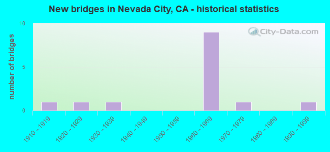
- New bridges - historical statistics
- 11910-1919
- 11920-1929
- 11930-1939
- 91960-1969
- 11970-1979
- 11990-1999


- Bridge Condition - Deck
- 70.0%Good
- 20.0%Fair
- 10.0%Poor

- Bridge Condition - Superstructure
- 70.0%Good
- 30.0%Fair

- Bridge Condition - Substructure
- 50.0%Good
- 20.0%Fair
- 30.0%Poor

- Bridge Condition - Channel
- 20.0%Excellent
- 20.0%Very good
- 20.0%Satisfactory
- 40.0%Fair
Find on map >> Show street view
Structure Number: 17 005, Location: 03-NEV-020-R12.85-GVY (Lat: 39.215722, Lng: -121.061878), Route carried "on" structure: State highway 20, Year Built: 1970, Status: Open, Structure Length: 14.54m (47.70ft), Average Daily Traffic: 43,000 (year 2009), Truck Traffic: 7%, Average Future Daily Traffic: 73,943 (year 2038), Design Load: HS 20, Features Intersected: SR 174 (COLFAX),AUBURN
Minimum Vertical Clearance: 30+ m (98+ ft), Kilometerpoint: 12.850, Lanes on structure: 4, Lanes under structure: 5, Base Highway Network: Yes (, Subroute: 1), Owner: State Highway Agency, Approaching Roadway Width: 21.0m (68.9ft), Skew: 39 degrees, Material/Design: Concrete continuous, Design/Construction: Box Beam or Girders - Multiple, Number Of Spans In Main Unit: 7, Length of Maximum Span: 28.3m (92.8ft), Curb-To-Curb Width: 21.0m (68.9ft), Out-to-Out Width: 22.6m (74.1ft)
Condition: Deck: Good, Superstructure: Good, Substructure: Good, Operating Rating: 64.2 metric tons, Method Used To Determine Operating Rating: Load Factor (LF), Inventory Rating: 38.6 metric tons, Method Used To Determine Inventory Rating: Load Factor (LF), Structural Evaluation: Better than present minimum criteria, Deck Geometry: Better than present minimum criteria, Underclear: Meets minimum limits, Approach Roadway Alignment: Equal to present desirable criteria, Designated Inspection Frequency: Every 48 months, Inspection Date: July 2020, Deck Structure Type: Concrete Cast-file-Place, Wearing Surface/Protective System: Wearing Surface: Bituminous, Membrane: Built-up
Find on map >> Show street view
Structure Number: 17 0053, Location: 03-NEV-020-R16.74-NEVC (Lat: 39.258797, Lng: -121.018561), Route carried "on" structure: City street , Year Built: 1967, Status: Open, Structure Length: 3.41m (11.19ft), Average Daily Traffic: 8,500 (year 2010), Truck Traffic: 10%, Average Future Daily Traffic: 26,018 (year 2042), Design Load: HS 20, Features Intersected: STATE ROUTE 20, Facility Carried by Structure: SACRAMENTO ST
Minimum Vertical Clearance: 30+ m (98+ ft), Kilometerpoint: 0.000, Lanes on structure: 2, Lanes under structure: 4, Owner: State Highway Agency, Approaching Roadway Width: 9.1m (29.9ft), Skew: 3 degrees, Material/Design: Prestressed concrete, Design/Construction: Box Beam or Girders - Multiple, Number Of Spans In Main Unit: 1, Length of Maximum Span: 33.0m (108.3ft), Curb or Sidewalk Widths: Left: 1.5m (4.9ft), Right: 1.5m (4.9ft), Curb-To-Curb Width: 9.8m (32.2ft), Out-to-Out Width: 13.4m (44.0ft)
Condition: Deck: Fair, Superstructure: Good, Substructure: Fair, Operating Rating: 46.7 metric tons, Method Used To Determine Operating Rating: Load and Resistance Factor Rating (LRFR) rating reported by rating factor(RF) method using HL-93 loadings, Inventory Rating: 30.5 metric tons, Method Used To Determine Inventory Rating: Load and Resistance Factor Rating (LRFR) rating reported by rating factor(RF) method using HL-93 loadings, Structural Evaluation: Somewhat better than minimum adequacy, Deck Geometry: Meets minimum limits, Underclear: High priority of corrective action, Approach Roadway Alignment: Equal to present desirable criteria, Designated Inspection Frequency: Every 24 months, Inspection Date: July 2020, Deck Structure Type: Concrete Cast-file-Place
Find on map >> Show street view
Structure Number: 17 0054, Location: 03-NEV-020-R16.87-NEVC (Lat: 39.260661, Lng: -121.017989), Route carried "on" structure: State highway 20, Year Built: 1967, Status: Open, Structure Length: 5.12m (16.80ft), Average Daily Traffic: 16,800 (year 2009), Truck Traffic: 6%, Average Future Daily Traffic: 44,160 (year 2038), Design Load: HS 20, Features Intersected: DEER CREEK
Minimum Vertical Clearance: 30+ m (98+ ft), Kilometerpoint: 16.870, Lanes on structure: 6, Base Highway Network: Yes (, Subroute: 1), Owner: State Highway Agency, Approaching Roadway Width: 25.0m (82.0ft), Skew: 29 degrees, Material/Design: Concrete continuous, Design/Construction: Tee Beam, Number Of Spans In Main Unit: 3, Length of Maximum Span: 22.6m (74.1ft), Curb-To-Curb Width: 25.0m (82.0ft), Out-to-Out Width: 25.6m (84.0ft)
Condition: Deck: Good, Superstructure: Good, Substructure: Good, Channel: Very good, Operating Rating: 91.4 metric tons, Method Used To Determine Operating Rating: Load Factor (LF), Inventory Rating: 55.1 metric tons, Method Used To Determine Inventory Rating: Load Factor (LF), Structural Evaluation: Better than present minimum criteria, Deck Geometry: Meets minimum limits, Waterway Adequacy: Equal to present desirable criteria, Approach Roadway Alignment: Equal to present desirable criteria, Designated Inspection Frequency: Every 48 months, Inspection Date: July 2020, Deck Structure Type: Concrete Cast-file-Place, Wearing Surface/Protective System: Wearing Surface: Bituminous
Find on map >> Show street view
Structure Number: 17 0055, Location: 03-NEV-020-R16.99-NEVC (Lat: 39.262181, Lng: -121.017139), Route carried "on" structure: City street , Year Built: 1967, Status: Open, Structure Length: 2.99m (9.81ft), Average Daily Traffic: 7,000 (year 2010), Truck Traffic: 10%, Average Future Daily Traffic: 18,733 (year 2042), Design Load: HS 20, Features Intersected: STATE ROUTE 20, Facility Carried by Structure: BROAD ST
Minimum Vertical Clearance: 30+ m (98+ ft), Kilometerpoint: 0.000, Lanes on structure: 2, Lanes under structure: 4, Owner: State Highway Agency, Approaching Roadway Width: 12.2m (40.0ft), Skew: 1 degrees, Material/Design: Prestressed concrete, Design/Construction: Box Beam or Girders - Multiple, Number Of Spans In Main Unit: 1, Length of Maximum Span: 28.3m (92.8ft), Curb or Sidewalk Widths: Left: 2.4m (7.9ft), Right: 2.4m (7.9ft), Curb-To-Curb Width: 12.2m (40.0ft), Out-to-Out Width: 17.7m (58.1ft)
Condition: Deck: Good, Superstructure: Good, Substructure: Fair, Operating Rating: 43.7 metric tons, Method Used To Determine Operating Rating: Load and Resistance Factor Rating (LRFR) rating reported by rating factor(RF) method using HL-93 loadings, Inventory Rating: 31.1 metric tons, Method Used To Determine Inventory Rating: Load and Resistance Factor Rating (LRFR) rating reported by rating factor(RF) method using HL-93 loadings, Structural Evaluation: Somewhat better than minimum adequacy, Deck Geometry: Somewhat better than minimum adequacy, Underclear: High priority of corrective action, Approach Roadway Alignment: Equal to present desirable criteria, Designated Inspection Frequency: Every 24 months, Inspection Date: July 2020, Deck Structure Type: Concrete Cast-file-Place, Wearing Surface/Protective System: Wearing Surface: Integral Concrete
Find on map >> Show street view
Structure Number: 17 0056, Location: 03-NEV-020-R17.18-NEVC (Lat: 39.264744, Lng: -121.016886), Route carried "on" structure: City street , Year Built: 1967, Status: Open, Structure Length: 3.29m (10.79ft), Average Daily Traffic: 7,500 (year 2010), Truck Traffic: 10%, Average Future Daily Traffic: 19,254 (year 2042), Design Load: HS 20, Features Intersected: STATE ROUTE 20, Facility Carried by Structure: WASHINGTON ST
Minimum Vertical Clearance: 30+ m (98+ ft), Kilometerpoint: 0.000, Lanes on structure: 2, Lanes under structure: 5, Owner: State Highway Agency, Approaching Roadway Width: 7.9m (25.9ft), Skew: 10 degrees, Material/Design: Prestressed concrete, Design/Construction: Box Beam or Girders - Multiple, Number Of Spans In Main Unit: 1, Length of Maximum Span: 31.4m (103.0ft), Curb or Sidewalk Widths: Left: 1.5m (4.9ft), Right: 1.5m (4.9ft), Curb-To-Curb Width: 8.5m (27.9ft), Out-to-Out Width: 12.2m (40.0ft)
Condition: Deck: Fair, Superstructure: Good, Substructure: Good, Operating Rating: 42.8 metric tons, Method Used To Determine Operating Rating: Load and Resistance Factor Rating (LRFR) rating reported by rating factor(RF) method using HL-93 loadings, Inventory Rating: 29.5 metric tons, Method Used To Determine Inventory Rating: Load and Resistance Factor Rating (LRFR) rating reported by rating factor(RF) method using HL-93 loadings, Structural Evaluation: Better than present minimum criteria, Deck Geometry: High priority of replacement, Underclear: High priority of corrective action, Approach Roadway Alignment: Equal to present desirable criteria, Designated Inspection Frequency: Every 24 months, Inspection Date: July 2020, Deck Structure Type: Concrete Cast-file-Place
Find on map >> Show street view
Structure Number: 17 0082, Location: 03-NEV-020-R15.92 (Lat: 39.248264, Lng: -121.024992), Route carried "on" structure: County highway , Year Built: 1967, Status: Open, Structure Length: 4.94m (16.21ft), Average Daily Traffic: 20,000 (year 2010), Truck Traffic: 10%, Average Future Daily Traffic: 31,222 (year 2042), Design Load: HS 20, Features Intersected: STATE ROUTE 20, Facility Carried by Structure: GOLD FLAT ROAD
Minimum Vertical Clearance: 30+ m (98+ ft), Kilometerpoint: 0.000, Lanes on structure: 2, Lanes under structure: 4, Owner: State Highway Agency, Approaching Roadway Width: 8.5m (27.9ft), Material/Design: Concrete continuous, Design/Construction: Box Beam or Girders - Multiple, Number Of Spans In Main Unit: 2, Length of Maximum Span: 25.6m (84.0ft), Curb or Sidewalk Widths: Left: 0.0m, Right: 1.5m (4.9ft), Curb-To-Curb Width: 9.1m (29.9ft), Out-to-Out Width: 11.3m (37.1ft)
Condition: Deck: Good, Superstructure: Good, Substructure: Good, Operating Rating: 37.3 metric tons, Method Used To Determine Operating Rating: Load and Resistance Factor Rating (LRFR) rating reported by rating factor(RF) method using HL-93 loadings, Inventory Rating: 28.5 metric tons, Method Used To Determine Inventory Rating: Load and Resistance Factor Rating (LRFR) rating reported by rating factor(RF) method using HL-93 loadings, Structural Evaluation: Better than present minimum criteria, Deck Geometry: High priority of corrective action, Underclear: Meets minimum limits, Approach Roadway Alignment: Equal to present desirable criteria, Designated Inspection Frequency: Every 24 months, Inspection Date: July 2020, Deck Structure Type: Concrete Cast-file-Place, Wearing Surface/Protective System: Wearing Surface: Integral Concrete
Find on map >> Show street view
Structure Number: 17C0001, Location: 0.1 MI SOUTH OF BROAD ST (Lat: 39.260428, Lng: -121.019442), Route carried "on" structure: City street , Year Built: 1996, Status: Open, Structure Length: 9.14m (29.99ft), Average Daily Traffic: 3,980 (year 2011), Truck Traffic: 1%, Average Future Daily Traffic: 4,578 (year 2041), Design Load: HS 20, Features Intersected: DEER CREEK, Facility Carried by Structure: SOUTH PINE STREET
Minimum Vertical Clearance: 30+ m (98+ ft), Kilometerpoint: 0.000, Lanes on structure: 2, Owner: City or Municipal Highway Agency, Approaching Roadway Width: 6.7m (22.0ft), Material/Design: Steel, Design/Construction: Truss - Deck, Number Of Spans In Main Unit: 1, Number Of Approach Spans: 10, Length of Maximum Span: 45.7m (149.9ft), Curb or Sidewalk Widths: Left: 1.2m (3.9ft), Right: 0.0m, Curb-To-Curb Width: 6.7m (22.0ft), Out-to-Out Width: 9.0m (29.5ft)
Condition: Deck: Good, Superstructure: Good, Substructure: Good, Channel: Excellent, Operating Rating: 26.6 metric tons, Method Used To Determine Operating Rating: Load Factor (LF), Inventory Rating: 15.9 metric tons, Method Used To Determine Inventory Rating: Load Factor (LF), Structural Evaluation: Meets minimum limits, Deck Geometry: High priority of replacement, Waterway Adequacy: Better than present minimum criteria, Approach Roadway Alignment: Equal to present minimum criteria, Designated Inspection Frequency: Every 24 months, Critical Feature Inspection Frequency: Every 24 months, Inspection Date: August 2021, Critical Feature Inspection Date: July 2021, Deck Structure Type: Concrete Cast-file-Place, Wearing Surface/Protective System: Deck Protection: Epoxy Coated Reinforcing
Find on map >> Show street view
Structure Number: 17C0002, Location: NEAR BROAD ST (Lat: 39.262214, Lng: -121.016147), Route carried "on" structure: City street , Year Built: 1938, Year Reconstructed: 1941, Status: Open, Structure Length: 1.86m (6.10ft), Average Daily Traffic: 3,300 (year 2007), Truck Traffic: 1%, Average Future Daily Traffic: 3,551 (year 2041), Features Intersected: DEER CREEK, Facility Carried by Structure: NEVADA STREET
Minimum Vertical Clearance: 30+ m (98+ ft), Kilometerpoint: 0.000, Lanes on structure: 2, Owner: City or Municipal Highway Agency, Approaching Roadway Width: 7.9m (25.9ft), Material/Design: Steel, Design/Construction: Stringer/Multi-beam, Number Of Spans In Main Unit: 2, Length of Maximum Span: 8.5m (27.9ft), Curb or Sidewalk Widths: Left: 1.2m (3.9ft), Right: 1.2m (3.9ft), Curb-To-Curb Width: 7.9m (25.9ft), Out-to-Out Width: 11.0m (36.1ft)
Condition: Deck: Poor, Superstructure: Fair, Substructure: Poor, Channel: Satisfactory, Operating Rating: 44.7 metric tons, Method Used To Determine Operating Rating: Load Factor (LF), Inventory Rating: 26.9 metric tons, Method Used To Determine Inventory Rating: Load Factor (LF), Structural Evaluation: Meets minimum limits, Deck Geometry: High priority of corrective action, Waterway Adequacy: Equal to present minimum criteria, Approach Roadway Alignment: Equal to present desirable criteria, Length Of Structure Improvement: 1.86m (6.10ft), Designated Inspection Frequency: Every 24 months, Inspection Date: August 2021, Bridge Improvement Cost: $193,000, Roadway Improvement Cost: $88,000, Total Project Cost: $745,000 ( Estimate for 2017), Deck Structure Type: Concrete Cast-file-Place
Find on map >> Show street view
Structure Number: 17C0057, Location: 1 MI E OF RECTOR RD (Lat: 39.302819, Lng: -121.004586), Route carried "on" structure: County highway , Year Built: 1920, Status: Posted for load, Structure Length: 0.91m (2.99ft), Average Daily Traffic: 80 (year 2012), Truck Traffic: 5%, Average Future Daily Traffic: 110 (year 2041), Features Intersected: ROCK CREEK, Facility Carried by Structure: ROCK CREEK RD
Minimum Vertical Clearance: 30+ m (98+ ft), Kilometerpoint: 0.000, Lanes on structure: 1, Owner: County Highway Agency, Approaching Roadway Width: 4.6m (15.1ft), Material/Design: Steel, Design/Construction: Stringer/Multi-beam, Number Of Spans In Main Unit: 1, Length of Maximum Span: 7.9m (25.9ft), Curb-To-Curb Width: 4.2m (13.8ft), Out-to-Out Width: 4.8m (15.7ft)
Condition: Deck: Good, Superstructure: Fair, Substructure: Poor, Channel: Fair, Operating Rating: 27.2 metric tons, Method Used To Determine Operating Rating: Load Factor (LF), Inventory Rating: 16.2 metric tons, Method Used To Determine Inventory Rating: Load Factor (LF), Structural Evaluation: Meets minimum limits, Deck Geometry: Somewhat better than minimum adequacy, Waterway Adequacy: Equal to present minimum criteria, Approach Roadway Alignment: Meets minimum limits, Length Of Structure Improvement: 0.91m (2.99ft), Designated Inspection Frequency: Every 24 months, Inspection Date: August 2021, Bridge Improvement Cost: $108,000, Roadway Improvement Cost: $21,000, Total Project Cost: $181,000 ( Estimate for 2017), Deck Structure Type: Wood or Timber, Wearing Surface/Protective System: Wearing Surface: Wood or Timber
Find on map >> Show street view
Structure Number: 17C0058, Location: 1 MI N OF ROCK CREEK RD (Lat: 39.303106, Lng: -121.021142), Route carried "on" structure: County highway , Year Built: 1915, Status: Posted for load, Structure Length: 0.91m (2.99ft), Average Daily Traffic: 62 (year 2014), Truck Traffic: 10%, Average Future Daily Traffic: 159 (year 2040), Features Intersected: ROCK CREEK, Facility Carried by Structure: RECTOR RD
Minimum Vertical Clearance: 30+ m (98+ ft), Kilometerpoint: 0.000, Lanes on structure: 1, Owner: County Highway Agency, Approaching Roadway Width: 4.3m (14.1ft), Material/Design: Steel, Design/Construction: Stringer/Multi-beam, Number Of Spans In Main Unit: 1, Length of Maximum Span: 7.9m (25.9ft), Curb-To-Curb Width: 3.5m (11.5ft), Out-to-Out Width: 3.7m (12.1ft)
Condition: Deck: Good, Superstructure: Fair, Substructure: Poor, Channel: Fair, Operating Rating: 23.7 metric tons, Method Used To Determine Operating Rating: Load Factor (LF), Inventory Rating: 14.3 metric tons, Method Used To Determine Inventory Rating: Load Factor (LF), Structural Evaluation: Meets minimum limits, Deck Geometry: High priority of corrective action, Waterway Adequacy: Somewhat better than minimum adequacy, Approach Roadway Alignment: Somewhat better than minimum adequacy, Bridge Posting: Required (Relationship of Operating Rating to Maximum Legal Load: 10.0 - 19.9% below), Length Of Structure Improvement: 0.91m (2.99ft), Designated Inspection Frequency: Every 12 months, Inspection Date: August 2021, Bridge Improvement Cost: $78,000, Roadway Improvement Cost: $15,000, Total Project Cost: $131,000 ( Estimate for 2020), Deck Structure Type: Wood or Timber, Wearing Surface/Protective System: Wearing Surface: Wood or Timber
Find on map >> Show street view
Structure Number: 17 0053, Location: 03-NEV-020-R16.74-NEVC (Lat: 39.258797, Lng: -121.018561), Route carried "under" structure: State highway 20, Year Built: 1967, Structure Length: 0. m, Average Daily Traffic: 16,800 (year 2009), Truck Traffic: 6%, Features Intersected: STATE ROUTE 20, Facility Carried by Structure: SACRAMENTO ST
Minimum Vertical Clearance: 4.47m (14.67ft), Kilometerpoint: 16.740, Lanes on structure: 2, Lanes under structure: 4, Material/Design: Prestressed concrete, Design/Construction: Box Beam or Girders - Multiple, Length of Maximum Span: 33.0m (108.3ft)
Find on map >> Show street view
Structure Number: 17 0055, Location: 03-NEV-020-R16.99-NEVC (Lat: 39.262181, Lng: -121.017139), Route carried "under" structure: State highway 20, Year Built: 1967, Structure Length: 0. m, Average Daily Traffic: 16,800 (year 2009), Truck Traffic: 6%, Features Intersected: STATE ROUTE 20, Facility Carried by Structure: BROAD ST
Minimum Vertical Clearance: 4.88m (16.01ft), Kilometerpoint: 16.990, Lanes on structure: 2, Lanes under structure: 4, Material/Design: Prestressed concrete, Design/Construction: Box Beam or Girders - Multiple, Length of Maximum Span: 28.3m (92.8ft)
Find on map >> Show street view
Structure Number: 17 0056, Location: 03-NEV-020-R17.18-NEVC (Lat: 39.264744, Lng: -121.016886), Route carried "under" structure: State highway 20, Year Built: 1967, Structure Length: 0. m, Average Daily Traffic: 16,800 (year 2009), Truck Traffic: 6%, Features Intersected: STATE ROUTE 20, Facility Carried by Structure: WASHINGTON ST
Minimum Vertical Clearance: 4.55m (14.93ft), Kilometerpoint: 17.180, Lanes on structure: 2, Lanes under structure: 5, Material/Design: Prestressed concrete, Design/Construction: Box Beam or Girders - Multiple, Length of Maximum Span: 31.4m (103.0ft)
Find on map >> Show street view
Structure Number: 17 0082, Location: 03-NEV-020-R15.92 (Lat: 39.248264, Lng: -121.024992), Route carried "under" structure: State highway 20, Year Built: 1967, Structure Length: 0. m, Average Daily Traffic: 33,500 (year 2009), Truck Traffic: 6%, Features Intersected: STATE ROUTE 20, Facility Carried by Structure: GOLD FLAT ROAD
Minimum Vertical Clearance: 5.92m (19.42ft), Kilometerpoint: 15.920, Lanes on structure: 2, Lanes under structure: 4, Material/Design: Concrete continuous, Design/Construction: Box Beam or Girders - Multiple, Length of Maximum Span: 25.6m (84.0ft)