Bridge Statistics for New Albany, Pennsylvania (PA)
Condition, Traffic, Stress, Structural Evaluation, Project Costs
- National Bridge Inventory (NBI) Statistics
- 10Number of bridges
- 43ft / 13.0mTotal length
- $517,000Total costs
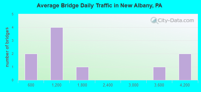
- 15,517Total average daily traffic
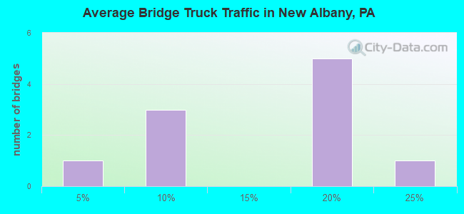
- 2,506Total average daily truck traffic
- 22,222Total future (year 2032) average daily traffic
- National Bridge Inventory (NBI) Registered Bridges for New Albany
- No street view available for this location
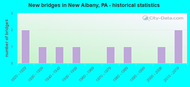
- New bridges - historical statistics
- 21920-1929
- 11930-1939
- 11940-1949
- 11950-1959
- 11970-1979
- 11980-1989
- 12000-2009
- 22010-2019
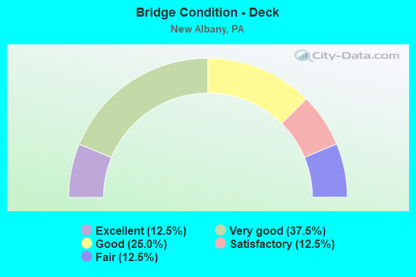
- Bridge Condition - Deck
- 12.5%Excellent
- 37.5%Very good
- 25.0%Good
- 12.5%Satisfactory
- 12.5%Fair
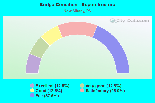
- Bridge Condition - Superstructure
- 12.5%Excellent
- 12.5%Very good
- 12.5%Good
- 25.0%Satisfactory
- 37.5%Fair
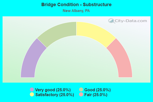
- Bridge Condition - Substructure
- 25.0%Very good
- 25.0%Good
- 25.0%Satisfactory
- 25.0%Fair
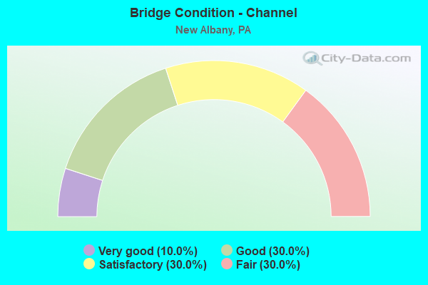
- Bridge Condition - Channel
- 10.0%Very good
- 30.0%Good
- 30.0%Satisfactory
- 30.0%Fair
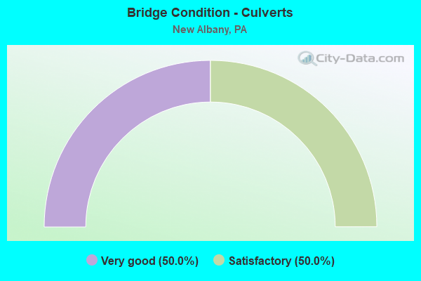
- Bridge Condition - Culverts
- 50.0%Very good
- 50.0%Satisfactory
Find on map >> Show street view
Structure Number: 6132, Location: NEW ALBANY BORO (Lat: 41.595078, Lng: -76.441178), Route carried "on" structure: US 220, Year Built: 1924, Status: Open, Structure Length: 0.64m (2.10ft), Average Daily Traffic: 3,151 (year 2022), Truck Traffic: 22%, Average Future Daily Traffic: 4,032 (year 2032), Features Intersected: OVER BEAVER RUN
Minimum Vertical Clearance: 30+ m (98+ ft), Kilometerpoint: 5.584, Lanes on structure: 2, Base Highway Network: Yes, Owner: State Highway Agency, Approaching Roadway Width: 8.8m (28.9ft), Skew: 3 degrees, Material/Design: Concrete, Design/Construction: Culvert, Number Of Spans In Main Unit: 1, Length of Maximum Span: 6.4m (21.0ft), Curb-To-Curb Width: 9.5m (31.2ft), Out-to-Out Width: 10.7m (35.1ft)
Condition: Channel: Fair, Culverts: Satisfactory, Operating Rating: 54.4 metric tons, Method Used To Determine Operating Rating: Field evaluation and documented engineering judgment, Inventory Rating: 32.7 metric tons, Method Used To Determine Inventory Rating: Field evaluation and documented engineering judgment, Structural Evaluation: Equal to present minimum criteria, Deck Geometry: Meets minimum limits, Waterway Adequacy: Superior to present desirable criteria, Approach Roadway Alignment: Equal to present desirable criteria, Length Of Structure Improvement: 0.60m (1.97ft), Designated Inspection Frequency: Every 24 months, Inspection Date: September 2021
Find on map >> Show street view
Structure Number: 6133, Location: NEW ALBANY BORO (Lat: 41.598694, Lng: -76.442494), Route carried "on" structure: US 220, Year Built: 1920, Status: Open, Structure Length: 0.76m (2.49ft), Average Daily Traffic: 3,634 (year 2022), Truck Traffic: 17%, Average Future Daily Traffic: 5,628 (year 2032), Design Load: H 20, Features Intersected: LADDS CREEK
Minimum Vertical Clearance: 30+ m (98+ ft), Kilometerpoint: 5.964, Lanes on structure: 2, Base Highway Network: Yes, Owner: State Highway Agency, Approaching Roadway Width: 10.7m (35.1ft), Skew: 3 degrees, Material/Design: Concrete continuous, Design/Construction: Stringer/Multi-beam, Number Of Spans In Main Unit: 1, Length of Maximum Span: 7.0m (23.0ft), Curb or Sidewalk Widths: Left: 2.4m (7.9ft), Right: 2.3m (7.5ft), Curb-To-Curb Width: 10.9m (35.8ft), Out-to-Out Width: 15.9m (52.2ft)
Condition: Deck: Satisfactory, Superstructure: Fair, Substructure: Fair, Channel: Good, Operating Rating: 54.4 metric tons, Method Used To Determine Operating Rating: Field evaluation and documented engineering judgment, Inventory Rating: 32.7 metric tons, Method Used To Determine Inventory Rating: Field evaluation and documented engineering judgment, Structural Evaluation: Somewhat better than minimum adequacy, Deck Geometry: Somewhat better than minimum adequacy, Waterway Adequacy: Superior to present desirable criteria, Approach Roadway Alignment: Equal to present desirable criteria, Length Of Structure Improvement: 0.80m (2.62ft), Designated Inspection Frequency: Every 24 months, Inspection Date: September 2021, Bridge Improvement Cost: $8,000, Roadway Improvement Cost: $24,000, Total Project Cost: $109,000, Deck Structure Type: Concrete Cast-file-Place, Wearing Surface/Protective System: Wearing Surface: Bituminous, Membrane: Preformed Fabric
Find on map >> Show street view
Structure Number: 6364, Location: NEW ALBANY BORO (Lat: 41.603083, Lng: -76.439097), Route carried "on" structure: State highway , Year Built: 1939, Year Reconstructed: 2010, Status: Open, Structure Length: 1.95m (6.40ft), Average Daily Traffic: 1,141 (year 2022), Truck Traffic: 9%, Average Future Daily Traffic: 1,529 (year 2032), Design Load: HL 93, Features Intersected: SOUTH BRANCH TOWANDA CRK, Facility Carried by Structure: SR 2010
Minimum Vertical Clearance: 30+ m (98+ ft), Kilometerpoint: 0.000, Lanes on structure: 2, Owner: State Highway Agency, Approaching Roadway Width: 6.4m (21.0ft), Material/Design: Steel, Design/Construction: Stringer/Multi-beam, Number Of Spans In Main Unit: 1, Length of Maximum Span: 18.9m (62.0ft), Curb-To-Curb Width: 7.3m (24.0ft), Out-to-Out Width: 8.2m (26.9ft)
Condition: Deck: Very good, Superstructure: Very good, Substructure: Satisfactory, Channel: Fair, Operating Rating: 94.3 metric tons, Method Used To Determine Operating Rating: Load and Resistance Factor (LRFR), Inventory Rating: 72.6 metric tons, Method Used To Determine Inventory Rating: Load and Resistance Factor (LRFR), Structural Evaluation: Equal to present minimum criteria, Deck Geometry: Meets minimum limits, Waterway Adequacy: Better than present minimum criteria, Approach Roadway Alignment: Somewhat better than minimum adequacy, Length Of Structure Improvement: 2.00m (6.56ft), Designated Inspection Frequency: Every 24 months, Inspection Date: September 2021, Bridge Improvement Cost: $15,000, Roadway Improvement Cost: $50,000, Total Project Cost: $206,000, Deck Structure Type: Concrete Cast-file-Place, Wearing Surface/Protective System: Wearing Surface: Bituminous, Membrane: Preformed Fabric, Deck Protection: Epoxy Coated Reinforcing
Find on map >> Show street view
Structure Number: 6365, Location: VILLAGE OF EVERGREEN (Lat: 41.619828, Lng: -76.415314), Route carried "on" structure: State highway , Year Built: 1959, Year Reconstructed: 2010, Status: Open, Structure Length: 0.85m (2.79ft), Average Daily Traffic: 837 (year 2022), Truck Traffic: 17%, Average Future Daily Traffic: 1,270 (year 2032), Features Intersected: TRIB.TO SUGAR RUN, Facility Carried by Structure: SR 2010
Minimum Vertical Clearance: 30+ m (98+ ft), Kilometerpoint: 3.135, Lanes on structure: 2, Owner: State Highway Agency, Approaching Roadway Width: 6.7m (22.0ft), Material/Design: Prestressed concrete, Design/Construction: Box Beam or Girders - Multiple, Number Of Spans In Main Unit: 1, Length of Maximum Span: 7.9m (25.9ft), Curb or Sidewalk Widths: Left: 0.1m (0.3ft), Right: 0.1m (0.3ft), Curb-To-Curb Width: 9.2m (30.2ft), Out-to-Out Width: 10.3m (33.8ft)
Condition: Deck: Good, Superstructure: Satisfactory, Substructure: Satisfactory, Channel: Satisfactory, Inventory Rating: 57.2 metric tons, Method Used To Determine Inventory Rating: Load Factor (LF), Structural Evaluation: Equal to present minimum criteria, Deck Geometry: Equal to present minimum criteria, Waterway Adequacy: Superior to present desirable criteria, Approach Roadway Alignment: Equal to present desirable criteria, Length Of Structure Improvement: 0.90m (2.95ft), Designated Inspection Frequency: Every 48 months, Inspection Date: September 2019, Bridge Improvement Cost: $6,000, Roadway Improvement Cost: $50,000, Total Project Cost: $80,000, Wearing Surface/Protective System: Wearing Surface: Monolithic Concrete, Deck Protection: Epoxy Coated Reinforcing
Find on map >> Show street view
Structure Number: 6366, Location: 1 MILE W.OF NEW ERA (Lat: 41.622256, Lng: -76.385514), Route carried "on" structure: State highway , Year Built: 1982, Status: Open, Structure Length: 1.01m (3.31ft), Average Daily Traffic: 837 (year 2022), Truck Traffic: 17%, Average Future Daily Traffic: 1,270 (year 2032), Features Intersected: SUGAR RUN, Facility Carried by Structure: SR 2010
Minimum Vertical Clearance: 30+ m (98+ ft), Kilometerpoint: 5.137, Lanes on structure: 2, Owner: State Highway Agency, Approaching Roadway Width: 6.7m (22.0ft), Skew: 3 degrees, Material/Design: Steel, Design/Construction: Stringer/Multi-beam, Number Of Spans In Main Unit: 1, Length of Maximum Span: 9.8m (32.2ft), Curb-To-Curb Width: 8.2m (26.9ft), Out-to-Out Width: 8.5m (27.9ft)
Condition: Deck: Good, Superstructure: Fair, Substructure: Good, Channel: Satisfactory, Operating Rating: 69.9 metric tons, Method Used To Determine Operating Rating: Load Factor (LF), Inventory Rating: 41.7 metric tons, Method Used To Determine Inventory Rating: Load Factor (LF), Structural Evaluation: Somewhat better than minimum adequacy, Deck Geometry: Somewhat better than minimum adequacy, Waterway Adequacy: Better than present minimum criteria, Approach Roadway Alignment: Equal to present desirable criteria, Length Of Structure Improvement: 1.00m (3.28ft), Designated Inspection Frequency: Every 24 months, Inspection Date: May 2020, Deck Structure Type: Closed Grating
Find on map >> Show street view
Structure Number: 6394, Location: NEW ALBANY BORO (Lat: 41.597192, Lng: -76.443300), Route carried "on" structure: State highway , Year Built: 1941, Status: Open, Structure Length: 0.88m (2.89ft), Average Daily Traffic: 661 (year 2022), Truck Traffic: 16%, Average Future Daily Traffic: 567 (year 2032), Features Intersected: LADDS CREEK, Facility Carried by Structure: SR 3002
Minimum Vertical Clearance: 30+ m (98+ ft), Kilometerpoint: 7.176, Lanes on structure: 2, Owner: State Highway Agency, Approaching Roadway Width: 5.5m (18.0ft), Skew: 3 degrees, Material/Design: Steel, Design/Construction: Stringer/Multi-beam, Number Of Spans In Main Unit: 1, Length of Maximum Span: 7.6m (24.9ft), Curb-To-Curb Width: 6.8m (22.3ft), Out-to-Out Width: 7.6m (24.9ft)
Condition: Deck: Fair, Superstructure: Fair, Substructure: Fair, Channel: Fair, Operating Rating: 92.5 metric tons, Method Used To Determine Operating Rating: Load Factor (LF), Inventory Rating: 55.3 metric tons, Method Used To Determine Inventory Rating: Load Factor (LF), Structural Evaluation: Somewhat better than minimum adequacy, Deck Geometry: Meets minimum limits, Waterway Adequacy: Better than present minimum criteria, Approach Roadway Alignment: Equal to present desirable criteria, Length Of Structure Improvement: 0.90m (2.95ft), Designated Inspection Frequency: Every 24 months, Inspection Date: September 2021, Bridge Improvement Cost: $9,000, Roadway Improvement Cost: $50,000, Total Project Cost: $122,000, Deck Structure Type: Concrete Cast-file-Place, Wearing Surface/Protective System: Wearing Surface: Bituminous, Membrane: Preformed Fabric
Find on map >> Show street view
Structure Number: 6559, Location: 0.1M NE SR 220, LADDSBURG (Lat: 41.574783, Lng: -76.417919), Route carried "on" structure: City street , Year Built: 1979, Year Reconstructed: 2016, Status: Open, Structure Length: 2.35m (7.71ft), Average Daily Traffic: 100 (year 2021), Truck Traffic: 7%, Average Future Daily Traffic: 155 (year 2043), Design Load: HS 20, Features Intersected: SOUTH BR. TOWANDA CREEK, Facility Carried by Structure: T-408 (CO.BR.1)
Minimum Vertical Clearance: 30+ m (98+ ft), Kilometerpoint: 0.000, Lanes on structure: 2, Owner: County Highway Agency, Approaching Roadway Width: 4.6m (15.1ft), Material/Design: Prestressed concrete, Design/Construction: Box Beam or Girders - Multiple, Number Of Spans In Main Unit: 1, Length of Maximum Span: 23.2m (76.1ft), Curb or Sidewalk Widths: Left: 0.2m (0.7ft), Right: 0.2m (0.7ft), Curb-To-Curb Width: 7.3m (24.0ft), Out-to-Out Width: 8.4m (27.6ft)
Condition: Deck: Very good, Superstructure: Satisfactory, Substructure: Good, Channel: Good, Operating Rating: 49.0 metric tons, Method Used To Determine Operating Rating: Load Factor (LF), Structural Evaluation: High priority of corrective action, Deck Geometry: Equal to present minimum criteria, Waterway Adequacy: Superior to present desirable criteria, Approach Roadway Alignment: Equal to present minimum criteria, Length Of Structure Improvement: 3.00m (9.84ft), Designated Inspection Frequency: Every 24 months, Inspection Date: July 2021, Deck Structure Type: Concrete Cast-file-Place, Wearing Surface/Protective System: Wearing Surface: Monolithic Concrete, Deck Protection: Epoxy Coated Reinforcing
Find on map >> Show street view
Structure Number: 43102, Location: .75 MI. SE OF NEW ALBANY (Lat: 41.589967, Lng: -76.432294), Route carried "on" structure: City street , Year Built: 2005, Status: Open, Structure Length: 1.71m (5.61ft), Average Daily Traffic: 200 (year 2021), Truck Traffic: 1%, Average Future Daily Traffic: 310 (year 2043), Design Load: HL 93, Features Intersected: SOUTH BR. TOWANDA CREEK, Facility Carried by Structure: TR-388 (CO. BR. 2)
Minimum Vertical Clearance: 30+ m (98+ ft), Kilometerpoint: 0.000, Lanes on structure: 2, Owner: County Highway Agency, Approaching Roadway Width: 7.0m (23.0ft), Skew: 2 degrees, Material/Design: Prestressed concrete, Design/Construction: Box Beam or Girders - Single/Spread, Number Of Spans In Main Unit: 1, Length of Maximum Span: 16.8m (55.1ft), Curb-To-Curb Width: 7.8m (25.6ft), Out-to-Out Width: 8.7m (28.5ft)
Condition: Deck: Very good, Superstructure: Good, Substructure: Very good, Channel: Satisfactory, Operating Rating: 93.4 metric tons, Method Used To Determine Operating Rating: Load and Resistance Factor (LRFR), Inventory Rating: 47.2 metric tons, Method Used To Determine Inventory Rating: Load and Resistance Factor (LRFR), Structural Evaluation: Better than present minimum criteria, Deck Geometry: Somewhat better than minimum adequacy, Waterway Adequacy: Superior to present desirable criteria, Approach Roadway Alignment: Better than present minimum criteria, Length Of Structure Improvement: 1.70m (5.58ft), Designated Inspection Frequency: Every 24 months, Inspection Date: July 2021, Deck Structure Type: Concrete Cast-file-Place, Wearing Surface/Protective System: Wearing Surface: Monolithic Concrete, Deck Protection: Epoxy Coated Reinforcing
Find on map >> Show street view
Structure Number: 53514, Location: BALD EAGLE (Lat: 40.722108, Lng: -78.184664), Route carried "on" structure: US 220B, Year Built: 2016, Status: Open, Structure Length: 0.73m (2.40ft), Average Daily Traffic: 1,322 (year 2022), Truck Traffic: 6%, Average Future Daily Traffic: 1,669 (year 2036), Design Load: HL 93, Features Intersected: TRIB BIG FILL RUN, Facility Carried by Structure: SR 4027
Minimum Vertical Clearance: 30+ m (98+ ft), Kilometerpoint: 11.618, Lanes on structure: 2, Owner: State Highway Agency, Approaching Roadway Width: 12.2m (40.0ft), Material/Design: Concrete, Design/Construction: Culvert, Number Of Spans In Main Unit: 1, Length of Maximum Span: 6.7m (22.0ft), Curb-To-Curb Width: 12.3m (40.4ft), Out-to-Out Width: 14.3m (46.9ft)
Condition: Channel: Good, Culverts: Very good, Operating Rating: 54.4 metric tons, Method Used To Determine Operating Rating: Assigned ratings based on Load and Resistance Factor Design (LRFD) reported by rating factor (RF) using HL93 loadings, Inventory Rating: 34.3 metric tons, Method Used To Determine Inventory Rating: Assigned ratings based on Load and Resistance Factor Design (LRFD) reported by rating factor (RF) using HL93 loadings, Structural Evaluation: Equal to present desirable criteria, Deck Geometry: Better than present minimum criteria, Waterway Adequacy: Equal to present minimum criteria, Approach Roadway Alignment: Equal to present desirable criteria, Designated Inspection Frequency: Every 48 months, Inspection Date: July 2020, Wearing Surface/Protective System: Wearing Surface: Bituminous, Membrane: Preformed Fabric, Deck Protection: Epoxy Coated Reinforcing
Find on map >> Show street view
Structure Number: 53523, Location: VILLAGE OF STEVENSON (Lat: 41.622069, Lng: -76.438850), Route carried "on" structure: US 220, Year Built: 2016, Status: Open, Structure Length: 2.13m (6.99ft), Average Daily Traffic: 3,634 (year 2022), Truck Traffic: 17%, Average Future Daily Traffic: 5,792 (year 2037), Design Load: HL 93, Features Intersected: S. Br. Towanda Creek
Minimum Vertical Clearance: 30+ m (98+ ft), Kilometerpoint: 8.542, Lanes on structure: 2, Base Highway Network: Yes, Owner: State Highway Agency, Maintenance Responsibility: Private, Approaching Roadway Width: 9.8m (32.2ft), Skew: 3 degrees, Material/Design: Prestressed concrete, Design/Construction: Box Beam or Girders - Single/Spread, Number Of Spans In Main Unit: 1, Length of Maximum Span: 21.3m (69.9ft), Curb-To-Curb Width: 12.2m (40.0ft), Out-to-Out Width: 12.8m (42.0ft)
Condition: Deck: Excellent, Superstructure: Excellent, Substructure: Very good, Channel: Very good, Operating Rating: 58.3 metric tons, Method Used To Determine Operating Rating: Assigned ratings based on Load and Resistance Factor Design (LRFD) reported by rating factor (RF) using HL93 loadings, Inventory Rating: 44.7 metric tons, Method Used To Determine Inventory Rating: Assigned ratings based on Load and Resistance Factor Design (LRFD) reported by rating factor (RF) using HL93 loadings, Structural Evaluation: Equal to present desirable criteria, Deck Geometry: Equal to present minimum criteria, Waterway Adequacy: Superior to present desirable criteria, Approach Roadway Alignment: Equal to present desirable criteria, Designated Inspection Frequency: Every 24 months, Inspection Date: July 2020, Deck Structure Type: Concrete Cast-file-Place, Wearing Surface/Protective System: Wearing Surface: Integral Concrete, Deck Protection: Epoxy Coated Reinforcing