Bridge Statistics for New Baltimore, Michigan (MI)
Condition, Traffic, Stress, Structural Evaluation, Project Costs
- National Bridge Inventory (NBI) Statistics
- 28Number of bridges
- 203ft / 62.3mTotal length
- $559,000Total costs
- 386,293Total average daily traffic
- 26,791Total average daily truck traffic
- National Bridge Inventory (NBI) Registered Bridges for New Baltimore
- No street view available for this location
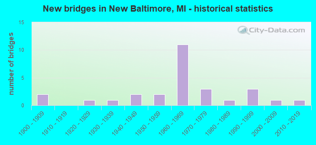
- New bridges - historical statistics
- 21900-1909
- 11920-1929
- 11930-1939
- 21940-1949
- 21950-1959
- 111960-1969
- 31970-1979
- 11980-1989
- 31990-1999
- 12000-2009
- 12010-2019
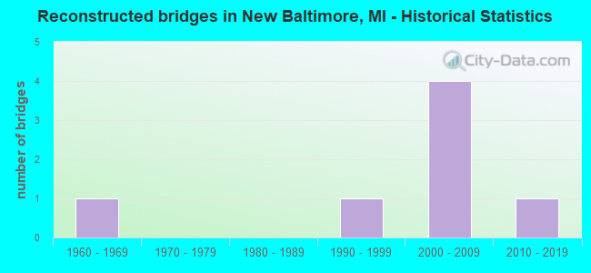
- Reconstructed bridges - Historical Statistics
- 11960-1969
- 01970-1979
- 01980-1989
- 11990-1999
- 42000-2009
- 12010-2019

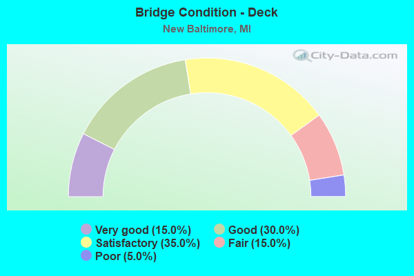
- Bridge Condition - Deck
- 15.0%Very good
- 30.0%Good
- 35.0%Satisfactory
- 15.0%Fair
- 5.0%Poor
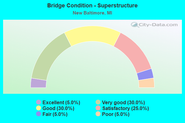
- Bridge Condition - Superstructure
- 5.0%Excellent
- 30.0%Very good
- 30.0%Good
- 25.0%Satisfactory
- 5.0%Fair
- 5.0%Poor
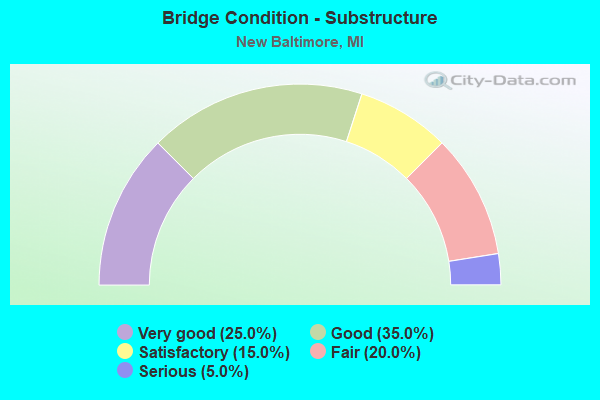
- Bridge Condition - Substructure
- 25.0%Very good
- 35.0%Good
- 15.0%Satisfactory
- 20.0%Fair
- 5.0%Serious
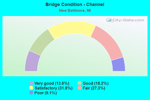
- Bridge Condition - Channel
- 13.6%Very good
- 18.2%Good
- 31.8%Satisfactory
- 27.3%Fair
- 9.1%Poor
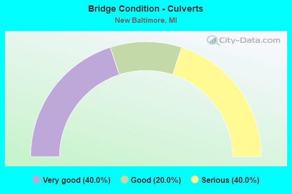
- Bridge Condition - Culverts
- 40.0%Very good
- 20.0%Good
- 40.0%Serious
Find on map >> Show street view
Structure Number: 6126, Location: 1.4 MI W OF NEW BALTIMORE (Lat: 42.675242, Lng: -82.785478), Route carried "on" structure: State highway 29, Year Built: 1972, Year Reconstructed: 2008, Status: Open, Structure Length: 1.22m (4.00ft), Average Daily Traffic: 37,832 (year 2007), Truck Traffic: 2%, Average Future Daily Traffic: 38,980 (year 2028), Design Load: HS 20, Features Intersected: FISH CREEK
Minimum Vertical Clearance: 30.48m (100.00ft), Kilometerpoint: 25.578, Lanes on structure: 5, Owner: State Highway Agency, Approaching Roadway Width: 19.5m (64.0ft), Skew: 1 degrees, Material/Design: Prestressed concrete, Design/Construction: Stringer/Multi-beam, Number Of Spans In Main Unit: 1, Length of Maximum Span: 12.2m (40.0ft), Curb or Sidewalk Widths: Left: 1.6m (5.2ft), Right: 1.6m (5.2ft), Curb-To-Curb Width: 19.5m (64.0ft), Out-to-Out Width: 23.9m (78.4ft)
Condition: Deck: Good, Superstructure: Very good, Substructure: Good, Channel: Fair, Operating Rating: 79.2 metric tons, Method Used To Determine Operating Rating: Load Factor (LF), Inventory Rating: 47.5 metric tons, Method Used To Determine Inventory Rating: Load Factor (LF), Structural Evaluation: Better than present minimum criteria, Deck Geometry: Meets minimum limits, Waterway Adequacy: Better than present minimum criteria, Approach Roadway Alignment: Equal to present desirable criteria, Designated Inspection Frequency: Every 24 months, Inspection Date: December 2021, Deck Structure Type: Concrete Cast-file-Place, Wearing Surface/Protective System: Wearing Surface: Latex Concrete
Find on map >> Show street view
Structure Number: 6127, Location: 0.7 MI W OF NEW BALTIMORE (Lat: 42.675606, Lng: -82.770892), Route carried "on" structure: State highway 29, Year Built: 1972, Year Reconstructed: 2008, Status: Open, Structure Length: 2.98m (9.78ft), Average Daily Traffic: 37,832 (year 2007), Truck Traffic: 2%, Average Future Daily Traffic: 38,980 (year 2028), Design Load: HS 20, Features Intersected: SALT RIVER
Minimum Vertical Clearance: 30.48m (100.00ft), Kilometerpoint: 26.774, Lanes on structure: 5, Base Highway Network: Yes (Inventory Route: 80, Subroute: 6), Owner: State Highway Agency, Approaching Roadway Width: 19.5m (64.0ft), Material/Design: Prestressed concrete, Design/Construction: Stringer/Multi-beam, Number Of Spans In Main Unit: 3, Length of Maximum Span: 10.0m (32.8ft), Curb or Sidewalk Widths: Left: 1.6m (5.2ft), Right: 1.6m (5.2ft), Curb-To-Curb Width: 19.5m (64.0ft), Out-to-Out Width: 23.9m (78.4ft)
Condition: Deck: Good, Superstructure: Satisfactory, Substructure: Good, Channel: Good, Operating Rating: 63.9 metric tons, Method Used To Determine Operating Rating: Load Factor (LF), Inventory Rating: 38.3 metric tons, Method Used To Determine Inventory Rating: Load Factor (LF), Structural Evaluation: Equal to present minimum criteria, Deck Geometry: Meets minimum limits, Waterway Adequacy: Equal to present minimum criteria, Approach Roadway Alignment: Equal to present desirable criteria, Designated Inspection Frequency: Every 24 months, Inspection Date: December 2021, Deck Structure Type: Concrete Cast-file-Place, Wearing Surface/Protective System: Wearing Surface: Latex Concrete
Find on map >> Show street view
Structure Number: 6128, Location: IN NEW BALTIMORE (Lat: 42.687653, Lng: -82.712053), Route carried "on" structure: State highway 29, Year Built: 1952, Status: Open, Structure Length: 0.91m (2.99ft), Average Daily Traffic: 20,326 (year 2007), Truck Traffic: 1%, Average Future Daily Traffic: 27,786 (year 2018), Design Load: HS 20, Features Intersected: MARSAC CREEK
Minimum Vertical Clearance: 30.48m (100.00ft), Kilometerpoint: 32.104, Lanes on structure: 5, Owner: State Highway Agency, Approaching Roadway Width: 20.1m (65.9ft), Material/Design: Concrete, Design/Construction: Tee Beam, Number Of Spans In Main Unit: 1, Length of Maximum Span: 9.1m (29.9ft), Curb-To-Curb Width: 16.7m (54.8ft), Out-to-Out Width: 18.5m (60.7ft)
Condition: Deck: Satisfactory, Superstructure: Satisfactory, Substructure: Fair, Channel: Fair, Operating Rating: 60.9 metric tons, Method Used To Determine Operating Rating: Load Factor (LF) rating reported by rating factor (RF) method using MS18 loading, Inventory Rating: 36.3 metric tons, Method Used To Determine Inventory Rating: Load Factor (LF) rating reported by rating factor (RF) method using MS18 loading, Structural Evaluation: Somewhat better than minimum adequacy, Deck Geometry: High priority of replacement, Waterway Adequacy: Equal to present minimum criteria, Approach Roadway Alignment: Equal to present desirable criteria, Designated Inspection Frequency: Every 24 months, Inspection Date: December 2021, Deck Structure Type: Concrete Cast-file-Place, Wearing Surface/Protective System: Wearing Surface: Integral Concrete, Membrane: Other
Find on map >> Show street view
Structure Number: 6179, Location: 0.4 MI NE OF M-19 (Lat: 42.709556, Lng: -82.769939), Route carried "on" structure: Interstate 94, Year Built: 1963, Status: Open, Structure Length: 3.78m (12.40ft), Average Daily Traffic: 23,428 (year 2007), Truck Traffic: 10%, Average Future Daily Traffic: 23,016 (year 2018), Design Load: HS 20+Mod, Features Intersected: SALT RIVER
Minimum Vertical Clearance: 30.48m (100.00ft), Kilometerpoint: 34.266, Lanes on structure: 2, Base Highway Network: Yes (Inventory Route: 79, Subroute: 1), Owner: State Highway Agency, Approaching Roadway Width: 14.0m (45.9ft), Skew: 1 degrees, Material/Design: Steel, Design/Construction: Stringer/Multi-beam, Number Of Spans In Main Unit: 2, Length of Maximum Span: 18.9m (62.0ft), Curb or Sidewalk Widths: Left: 0.1m (0.3ft), Right: 0.1m (0.3ft), Curb-To-Curb Width: 12.2m (40.0ft), Out-to-Out Width: 13.0m (42.7ft)
Condition: Deck: Satisfactory, Superstructure: Satisfactory, Substructure: Good, Channel: Poor, Operating Rating: 91.4 metric tons, Method Used To Determine Operating Rating: Load Factor (LF) rating reported by rating factor (RF) method using MS18 loading, Inventory Rating: 54.8 metric tons, Method Used To Determine Inventory Rating: Load Factor (LF) rating reported by rating factor (RF) method using MS18 loading, Structural Evaluation: Equal to present minimum criteria, Deck Geometry: Better than present minimum criteria, Waterway Adequacy: Equal to present desirable criteria, Approach Roadway Alignment: Better than present minimum criteria, Designated Inspection Frequency: Every 24 months, Inspection Date: June 2021, Deck Structure Type: Concrete Cast-file-Place, Wearing Surface/Protective System: Wearing Surface: Latex Concrete
Find on map >> Show street view
Structure Number: 618, Location: 0.4 MI NE OF M-19 (Lat: 42.709833, Lng: -82.770039), Route carried "on" structure: Interstate 94, Year Built: 1963, Status: Open, Structure Length: 3.78m (12.40ft), Average Daily Traffic: 23,428 (year 2007), Truck Traffic: 10%, Average Future Daily Traffic: 23,016 (year 2018), Design Load: HS 20+Mod, Features Intersected: SALT RIVER
Minimum Vertical Clearance: 30.48m (100.00ft), Kilometerpoint: 34.378, Lanes on structure: 2, Base Highway Network: Yes (Inventory Route: 79, Subroute: 2), Owner: State Highway Agency, Approaching Roadway Width: 14.0m (45.9ft), Skew: 1 degrees, Material/Design: Steel, Design/Construction: Stringer/Multi-beam, Number Of Spans In Main Unit: 2, Length of Maximum Span: 18.9m (62.0ft), Curb or Sidewalk Widths: Left: 0.1m (0.3ft), Right: 0.1m (0.3ft), Curb-To-Curb Width: 12.2m (40.0ft), Out-to-Out Width: 13.0m (42.7ft)
Condition: Deck: Satisfactory, Superstructure: Good, Substructure: Good, Channel: Fair, Operating Rating: 91.4 metric tons, Method Used To Determine Operating Rating: Load Factor (LF) rating reported by rating factor (RF) method using MS18 loading, Inventory Rating: 54.8 metric tons, Method Used To Determine Inventory Rating: Load Factor (LF) rating reported by rating factor (RF) method using MS18 loading, Structural Evaluation: Better than present minimum criteria, Deck Geometry: Better than present minimum criteria, Waterway Adequacy: Equal to present desirable criteria, Approach Roadway Alignment: Better than present minimum criteria, Length Of Structure Improvement: 3.78m (12.40ft), Designated Inspection Frequency: Every 24 months, Inspection Date: June 2021, Bridge Improvement Cost: $88,000, Roadway Improvement Cost: $7,000, Total Project Cost: $81,000, Deck Structure Type: Concrete Cast-file-Place, Wearing Surface/Protective System: Wearing Surface: Latex Concrete
Find on map >> Show street view
Structure Number: 6183, Location: @ M-19 (Lat: 42.707081, Lng: -82.773656), Route carried "on" structure: State highway 19, Year Built: 1963, Status: Open, Structure Length: 6.58m (21.59ft), Average Daily Traffic: 12,256 (year 2007), Truck Traffic: 3%, Average Future Daily Traffic: 20,126 (year 2018), Design Load: HS 20, Features Intersected: I-94
Minimum Vertical Clearance: 30.48m (100.00ft), Kilometerpoint: 4.529, Lanes on structure: 2, Lanes under structure: 4, Base Highway Network: Yes (Inventory Route: 81, Subroute: 5), Owner: State Highway Agency, Approaching Roadway Width: 14.9m (48.9ft), Material/Design: Steel, Design/Construction: Stringer/Multi-beam, Number Of Spans In Main Unit: 4, Length of Maximum Span: 21.3m (69.9ft), Curb or Sidewalk Widths: Left: 0.7m (2.3ft), Right: 0.7m (2.3ft), Curb-To-Curb Width: 9.1m (29.9ft), Out-to-Out Width: 11.4m (37.4ft)
Condition: Deck: Satisfactory, Superstructure: Good, Substructure: Fair, Operating Rating: 85.5 metric tons, Method Used To Determine Operating Rating: Load Factor (LF) rating reported by rating factor (RF) method using MS18 loading, Inventory Rating: 51.5 metric tons, Method Used To Determine Inventory Rating: Load Factor (LF) rating reported by rating factor (RF) method using MS18 loading, Structural Evaluation: Somewhat better than minimum adequacy, Deck Geometry: Meets minimum limits, Underclear: Meets minimum limits, Approach Roadway Alignment: Better than present minimum criteria, Designated Inspection Frequency: Every 24 months, Inspection Date: May 2020, Deck Structure Type: Concrete Cast-file-Place, Wearing Surface/Protective System: Wearing Surface: Integral Concrete
Find on map >> Show street view
Structure Number: 6184, Location: 1.5 MI SW OF ST CLAIR COL (Lat: 42.720281, Lng: -82.753269), Route carried "on" structure: County highway 5060, Year Built: 1963, Status: Open, Structure Length: 10.85m (35.60ft), Average Daily Traffic: 12,794 (year 1994), Truck Traffic: 3%, Average Future Daily Traffic: 14,713 (year 2014), Design Load: H 20, Features Intersected: I-94, Facility Carried by Structure: 26 MI RD
Minimum Vertical Clearance: 30.48m (100.00ft), Kilometerpoint: 27.746, Lanes on structure: 2, Lanes under structure: 4, Owner: State Highway Agency, Approaching Roadway Width: 13.1m (43.0ft), Skew: 5 degrees, Material/Design: Steel, Design/Construction: Stringer/Multi-beam, Number Of Spans In Main Unit: 4, Length of Maximum Span: 35.9m (117.8ft), Curb or Sidewalk Widths: Left: 0.7m (2.3ft), Right: 0.7m (2.3ft), Curb-To-Curb Width: 8.5m (27.9ft), Out-to-Out Width: 10.7m (35.1ft)
Condition: Deck: Satisfactory, Superstructure: Good, Substructure: Satisfactory, Operating Rating: 67.1 metric tons, Method Used To Determine Operating Rating: Load Factor (LF) rating reported by rating factor (RF) method using MS18 loading, Inventory Rating: 40.2 metric tons, Method Used To Determine Inventory Rating: Load Factor (LF) rating reported by rating factor (RF) method using MS18 loading, Structural Evaluation: Equal to present minimum criteria, Deck Geometry: Meets minimum limits, Underclear: Meets minimum limits, Approach Roadway Alignment: Better than present minimum criteria, Designated Inspection Frequency: Every 24 months, Inspection Date: June 2021, Deck Structure Type: Concrete Cast-file-Place, Wearing Surface/Protective System: Wearing Surface: Latex Concrete
Find on map >> Show street view
Structure Number: 6185, Location: ST CLAIR CO LINE (Lat: 42.733633, Lng: -82.730578), Route carried "on" structure: County highway 7741, Year Built: 1963, Status: Open, Structure Length: 8.17m (26.80ft), Average Daily Traffic: 6,252 (year 1996), Truck Traffic: 3%, Average Future Daily Traffic: 2,630 (year 2015), Design Load: H 20, Features Intersected: I-94, Facility Carried by Structure: CO LINE RD
Minimum Vertical Clearance: 30.48m (100.00ft), Kilometerpoint: 3.064, Lanes on structure: 2, Lanes under structure: 4, Owner: State Highway Agency, Approaching Roadway Width: 13.1m (43.0ft), Skew: 3 degrees, Material/Design: Steel, Design/Construction: Stringer/Multi-beam, Number Of Spans In Main Unit: 4, Length of Maximum Span: 26.8m (87.9ft), Curb or Sidewalk Widths: Left: 0.7m (2.3ft), Right: 0.7m (2.3ft), Curb-To-Curb Width: 7.9m (25.9ft), Out-to-Out Width: 10.1m (33.1ft)
Condition: Deck: Fair, Superstructure: Good, Substructure: Good, Operating Rating: 61.2 metric tons, Method Used To Determine Operating Rating: Load Factor (LF) rating reported by rating factor (RF) method using MS18 loading, Inventory Rating: 36.6 metric tons, Method Used To Determine Inventory Rating: Load Factor (LF) rating reported by rating factor (RF) method using MS18 loading, Structural Evaluation: Better than present minimum criteria, Deck Geometry: High priority of corrective action, Underclear: Meets minimum limits, Approach Roadway Alignment: Better than present minimum criteria, Designated Inspection Frequency: Every 24 months, Inspection Date: June 2021, Deck Structure Type: Concrete Cast-file-Place, Wearing Surface/Protective System: Wearing Surface: Latex Concrete
Find on map >> Show street view
Structure Number: 6276, Location: 400 FT N OF GREEN STREET (Lat: 42.682303, Lng: -82.738317), Route carried "on" structure: County highway 2058, Year Built: 1968, Status: Open, Structure Length: 0.70m (2.30ft), Average Daily Traffic: 9,770 (year 2008), Truck Traffic: 5%, Average Future Daily Traffic: 16,013 (year 2028), Design Load: H 20, Features Intersected: CREPEAU CREEK, Facility Carried by Structure: WASHINGTON ST
Minimum Vertical Clearance: 30.48m (100.00ft), Kilometerpoint: 0.513, Lanes on structure: 4, Owner: County Highway Agency, Approaching Roadway Width: 12.0m (39.4ft), Skew: 2 degrees, Material/Design: Concrete, Design/Construction: Culvert, Number Of Spans In Main Unit: 2, Length of Maximum Span: 3.3m (10.8ft), Curb or Sidewalk Widths: Left: 1.2m (3.9ft), Right: 1.2m (3.9ft)
Condition: Channel: Poor, Culverts: Good, Operating Rating: 28.8 metric tons, Method Used To Determine Operating Rating: Load Factor (LF) rating reported by rating factor (RF) method using MS18 loading, Inventory Rating: 17.2 metric tons, Method Used To Determine Inventory Rating: Load Factor (LF) rating reported by rating factor (RF) method using MS18 loading, Structural Evaluation: Meets minimum limits, Waterway Adequacy: Meets minimum limits, Approach Roadway Alignment: Equal to present desirable criteria, Designated Inspection Frequency: Every 24 months, Inspection Date: August 2021
Find on map >> Show street view
Structure Number: 6277, Location: 0.1 MILE WEST OF BAKER RD (Lat: 42.700786, Lng: -82.765658), Route carried "on" structure: County highway 5085, Year Built: 1965, Status: Posted for load, Structure Length: 1.82m (5.97ft), Average Daily Traffic: 16,400 (year 2020), Truck Traffic: 5%, Average Future Daily Traffic: 18,800 (year 2040), Design Load: HS 20, Features Intersected: SALT RIVER, Facility Carried by Structure: NEW HAVEN RD
Minimum Vertical Clearance: 30.48m (100.00ft), Kilometerpoint: 3.570, Lanes on structure: 2, Owner: County Highway Agency, Approaching Roadway Width: 13.0m (42.7ft), Material/Design: Steel, Design/Construction: Stringer/Multi-beam, Number Of Spans In Main Unit: 1, Length of Maximum Span: 17.6m (57.7ft), Curb or Sidewalk Widths: Left: 0.4m (1.3ft), Right: 0.9m (3.0ft), Curb-To-Curb Width: 9.0m (29.5ft), Out-to-Out Width: 10.6m (34.8ft)
Condition: Deck: Poor, Superstructure: Poor, Substructure: Serious, Channel: Satisfactory, Operating Rating: 27.5 metric tons, Method Used To Determine Operating Rating: Load Factor (LF) rating reported by rating factor (RF) method using MS18 loading, Inventory Rating: 16.5 metric tons, Method Used To Determine Inventory Rating: Load Factor (LF) rating reported by rating factor (RF) method using MS18 loading, Structural Evaluation: High priority of corrective action, Deck Geometry: High priority of replacement, Waterway Adequacy: Equal to present desirable criteria, Approach Roadway Alignment: Equal to present desirable criteria, Bridge Posting: Required (Relationship of Operating Rating to Maximum Legal Load: > 39.9% below), Length Of Structure Improvement: 1.83m (6.00ft), Designated Inspection Frequency: Every 12 months, Inspection Date: September 2021, Bridge Improvement Cost: $90,000, Roadway Improvement Cost: $20,000, Total Project Cost: $110,000, Deck Structure Type: Concrete Cast-file-Place, Wearing Surface/Protective System: Wearing Surface: Monolithic Concrete
Find on map >> Show street view
Structure Number: 6283, Location: 0.5 MI EAST OF SUGARBUSH (Lat: 42.667867, Lng: -82.783272), Route carried "on" structure: County highway , Year Built: 1964, Status: Open, Structure Length: 0.94m (3.08ft), Average Daily Traffic: 3,840 (year 2008), Truck Traffic: 3%, Average Future Daily Traffic: 5,706 (year 2028), Design Load: HS 20, Features Intersected: FISH CREEK, Facility Carried by Structure: CALLENS RD
Minimum Vertical Clearance: 30.48m (100.00ft), Kilometerpoint: 0.838, Lanes on structure: 2, Owner: County Highway Agency, Approaching Roadway Width: 9.1m (29.9ft), Material/Design: Steel, Design/Construction: Stringer/Multi-beam, Number Of Spans In Main Unit: 1, Length of Maximum Span: 8.5m (27.9ft), Curb or Sidewalk Widths: Left: 0.4m (1.3ft), Right: 0.4m (1.3ft), Curb-To-Curb Width: 9.1m (29.9ft), Out-to-Out Width: 10.1m (33.1ft)
Condition: Deck: Fair, Superstructure: Satisfactory, Substructure: Very good, Channel: Very good, Operating Rating: 83.9 metric tons, Method Used To Determine Operating Rating: Load Factor (LF) rating reported by rating factor (RF) method using MS18 loading, Inventory Rating: 50.2 metric tons, Method Used To Determine Inventory Rating: Load Factor (LF) rating reported by rating factor (RF) method using MS18 loading, Structural Evaluation: Equal to present minimum criteria, Deck Geometry: Meets minimum limits, Waterway Adequacy: Better than present minimum criteria, Approach Roadway Alignment: Better than present minimum criteria, Designated Inspection Frequency: Every 24 months, Underwater Inspection Frequency: Every 60 months, Inspection Date: September 2020, Underwater Inspection Date: August 2018, Deck Structure Type: Concrete Cast-file-Place, Wearing Surface/Protective System: Wearing Surface: Monolithic Concrete
Find on map >> Show street view
Structure Number: 6284, Location: 0.5 SOUTH OF 23 MILE ROAD (Lat: 42.671172, Lng: -82.774389), Route carried "on" structure: County highway , Year Built: 1983, Status: Open, Structure Length: 3.96m (12.99ft), Average Daily Traffic: 4,200 (year 2019), Truck Traffic: 3%, Average Future Daily Traffic: 4,400 (year 2039), Design Load: HS 20, Features Intersected: SALT RIVER, Facility Carried by Structure: CALLENS RD
Minimum Vertical Clearance: 30.48m (100.00ft), Kilometerpoint: 1.677, Lanes on structure: 2, Owner: County Highway Agency, Approaching Roadway Width: 12.0m (39.4ft), Skew: 3 degrees, Material/Design: Prestressed concrete, Design/Construction: Stringer/Multi-beam, Number Of Spans In Main Unit: 2, Length of Maximum Span: 18.9m (62.0ft), Curb or Sidewalk Widths: Left: 0.0m, Right: 2.0m (6.6ft), Curb-To-Curb Width: 10.0m (32.8ft), Out-to-Out Width: 12.7m (41.7ft)
Condition: Deck: Satisfactory, Superstructure: Good, Substructure: Good, Channel: Good, Operating Rating: 58.0 metric tons, Method Used To Determine Operating Rating: Load Factor (LF) rating reported by rating factor (RF) method using MS18 loading, Inventory Rating: 34.7 metric tons, Method Used To Determine Inventory Rating: Load Factor (LF) rating reported by rating factor (RF) method using MS18 loading, Structural Evaluation: Better than present minimum criteria, Deck Geometry: Meets minimum limits, Waterway Adequacy: Superior to present desirable criteria, Approach Roadway Alignment: Equal to present desirable criteria, Designated Inspection Frequency: Every 24 months, Underwater Inspection Frequency: Every 60 months, Inspection Date: August 2021, Underwater Inspection Date: August 2018, Deck Structure Type: Concrete Cast-file-Place, Wearing Surface/Protective System: Wearing Surface: Latex Concrete, Deck Protection: Epoxy Coated Reinforcing
Find on map >> Show street view
Structure Number: 6312, Location: 0.5 MI NORTH OF 23 MILE (Lat: 42.682189, Lng: -82.787431), Route carried "on" structure: County highway , Year Built: 1999, Status: Open, Structure Length: 0.61m (2.00ft), Average Daily Traffic: 2,190 (year 2011), Truck Traffic: 2%, Average Future Daily Traffic: 3,589 (year 2031), Design Load: HS 25 or greater, Features Intersected: FISH CREEK, Facility Carried by Structure: SASS ROAD
Minimum Vertical Clearance: 30.48m (100.00ft), Kilometerpoint: 1.605, Lanes on structure: 2, Owner: County Highway Agency, Approaching Roadway Width: 11.0m (36.1ft), Skew: 1 degrees, Material/Design: Concrete, Design/Construction: Culvert, Number Of Spans In Main Unit: 1, Length of Maximum Span: 6.1m (20.0ft), Curb or Sidewalk Widths: Left: 2.5m (8.2ft), Right: 2.5m (8.2ft), Curb-To-Curb Width: 12.0m (39.4ft), Out-to-Out Width: 18.6m (61.0ft)
Condition: Channel: Satisfactory, Culverts: Very good, Operating Rating: 52.2 metric tons, Method Used To Determine Operating Rating: Load Factor (LF) rating reported by rating factor (RF) method using MS18 loading, Inventory Rating: 38.9 metric tons, Method Used To Determine Inventory Rating: Load Factor (LF) rating reported by rating factor (RF) method using MS18 loading, Structural Evaluation: Equal to present desirable criteria, Deck Geometry: Somewhat better than minimum adequacy, Waterway Adequacy: Superior to present desirable criteria, Approach Roadway Alignment: Equal to present desirable criteria, Designated Inspection Frequency: Every 24 months, Inspection Date: August 2021
Find on map >> Show street view
Structure Number: 6314, Location: 0.1 MI WEST OF BAKER ROAD (Lat: 42.690367, Lng: -82.767381), Route carried "on" structure: County highway , Year Built: 1996, Status: Open, Structure Length: 3.96m (12.99ft), Average Daily Traffic: 4,270 (year 2008), Truck Traffic: 3%, Average Future Daily Traffic: 6,345 (year 2028), Design Load: HS 20, Features Intersected: SALT RIVER, Facility Carried by Structure: 24 MILE ROAD
Minimum Vertical Clearance: 30.48m (100.00ft), Kilometerpoint: 2.322, Lanes on structure: 2, Owner: County Highway Agency, Approaching Roadway Width: 12.0m (39.4ft), Material/Design: Prestressed concrete, Design/Construction: Stringer/Multi-beam, Number Of Spans In Main Unit: 2, Length of Maximum Span: 19.2m (63.0ft), Curb or Sidewalk Widths: Left: 1.8m (5.9ft), Right: 1.8m (5.9ft), Curb-To-Curb Width: 12.0m (39.4ft), Out-to-Out Width: 16.6m (54.5ft)
Condition: Deck: Good, Superstructure: Very good, Substructure: Very good, Channel: Good, Operating Rating: 54.1 metric tons, Method Used To Determine Operating Rating: Load Factor (LF) rating reported by rating factor (RF) method using MS18 loading, Inventory Rating: 32.4 metric tons, Method Used To Determine Inventory Rating: Load Factor (LF) rating reported by rating factor (RF) method using MS18 loading, Structural Evaluation: Equal to present desirable criteria, Deck Geometry: Somewhat better than minimum adequacy, Waterway Adequacy: Equal to present minimum criteria, Approach Roadway Alignment: Equal to present desirable criteria, Designated Inspection Frequency: Every 24 months, Inspection Date: September 2020, Deck Structure Type: Concrete Cast-file-Place, Wearing Surface/Protective System: Wearing Surface: Monolithic Concrete, Deck Protection: Epoxy Coated Reinforcing
Find on map >> Show street view
Structure Number: 6416, Location: EAST OF M-29 (Lat: 42.675792, Lng: -82.742869), Route carried "on" structure: City street , Year Built: 1925, Year Reconstructed: 1997, Status: Open, Structure Length: 1.21m (3.97ft), Average Daily Traffic: 1,310 (year 2005), Truck Traffic: 5%, Average Future Daily Traffic: 2,000 (year 2025), Design Load: HS 20, Features Intersected: CRAPEAU CREEK, Facility Carried by Structure: MAIN STREET
Minimum Vertical Clearance: 30.48m (100.00ft), Kilometerpoint: 0.122, Lanes on structure: 2, Owner: City or Municipal Highway Agency, Approaching Roadway Width: 6.7m (22.0ft), Skew: 1 degrees, Material/Design: Prestressed concrete, Design/Construction: Box Beam or Girders - Multiple, Number Of Spans In Main Unit: 1, Length of Maximum Span: 10.9m (35.8ft), Curb-To-Curb Width: 10.4m (34.1ft), Out-to-Out Width: 11.5m (37.7ft)
Condition: Deck: Good, Superstructure: Very good, Substructure: Satisfactory, Channel: Good, Operating Rating: 54.5 metric tons, Method Used To Determine Operating Rating: Field evaluation and documented engineering judgment, Inventory Rating: 32.7 metric tons, Method Used To Determine Inventory Rating: Field evaluation and documented engineering judgment, Structural Evaluation: Equal to present minimum criteria, Deck Geometry: Equal to present minimum criteria, Waterway Adequacy: Equal to present minimum criteria, Approach Roadway Alignment: Equal to present minimum criteria, Designated Inspection Frequency: Every 24 months, Inspection Date: November 2021, Deck Structure Type: Concrete Cast-file-Place, Wearing Surface/Protective System: Wearing Surface: Monolithic Concrete
Find on map >> Show street view
Structure Number: 6417, Location: WEST OF M-29 (Lat: 42.685281, Lng: -82.734472), Route carried "on" structure: City street , Year Built: 1900, Status: Posted for load, Structure Length: 0.67m (2.20ft), Average Daily Traffic: 1,470 (year 2002), Truck Traffic: 5%, Average Future Daily Traffic: 2,200 (year 2022), Design Load: HS 20+Mod, Features Intersected: CRAPEAU CREEK, Facility Carried by Structure: ASHLEY ST
Minimum Vertical Clearance: 30.48m (100.00ft), Kilometerpoint: 0.639, Lanes on structure: 2, Owner: City or Municipal Highway Agency, Approaching Roadway Width: 9.1m (29.9ft), Material/Design: Steel, Design/Construction: Culvert, Number Of Spans In Main Unit: 1, Length of Maximum Span: 4.8m (15.7ft)
Condition: Channel: Satisfactory, Culverts: Serious, Operating Rating: 54.1 metric tons, Method Used To Determine Operating Rating: Load Factor (LF) rating reported by rating factor (RF) method using MS18 loading, Inventory Rating: 32.4 metric tons, Method Used To Determine Inventory Rating: Load Factor (LF) rating reported by rating factor (RF) method using MS18 loading, Structural Evaluation: High priority of corrective action, Waterway Adequacy: Equal to present minimum criteria, Approach Roadway Alignment: Equal to present desirable criteria, Designated Inspection Frequency: Every 12 months, Inspection Date: November 2021
Find on map >> Show street view
Structure Number: 6418, Location: WEST OF M-29 (Lat: 42.680767, Lng: -82.740161), Route carried "on" structure: City street , Year Built: 1900, Status: Posted for load, Structure Length: 0.67m (2.20ft), Average Daily Traffic: 800 (year 2002), Truck Traffic: 5%, Average Future Daily Traffic: 1,200 (year 2022), Design Load: HS 20+Mod, Features Intersected: CRAPEAU CREEK, Facility Carried by Structure: BASE ST
Minimum Vertical Clearance: 30.48m (100.00ft), Kilometerpoint: 0.489, Lanes on structure: 2, Owner: City or Municipal Highway Agency, Approaching Roadway Width: 7.9m (25.9ft), Material/Design: Steel, Design/Construction: Culvert, Number Of Spans In Main Unit: 1, Length of Maximum Span: 4.5m (14.8ft)
Condition: Channel: Fair, Culverts: Serious, Operating Rating: 90.1 metric tons, Method Used To Determine Operating Rating: Load Factor (LF) rating reported by rating factor (RF) method using MS18 loading, Inventory Rating: 54.1 metric tons, Method Used To Determine Inventory Rating: Load Factor (LF) rating reported by rating factor (RF) method using MS18 loading, Structural Evaluation: High priority of corrective action, Waterway Adequacy: Equal to present minimum criteria, Approach Roadway Alignment: Equal to present desirable criteria, Designated Inspection Frequency: Every 12 months, Inspection Date: November 2021
Find on map >> Show street view
Structure Number: 9968, Location: 3.9 MI SE OF MACOMB COL (Lat: 42.680286, Lng: -82.657783), Route carried "on" structure: State highway 29, Year Built: 1932, Year Reconstructed: 1973, Status: Open, Structure Length: 1.77m (5.81ft), Average Daily Traffic: 14,431 (year 2007), Truck Traffic: 2%, Average Future Daily Traffic: 17,903 (year 2018), Design Load: HS 20, Features Intersected: SWAN CREEK
Minimum Vertical Clearance: 30.48m (100.00ft), Kilometerpoint: 4.495, Lanes on structure: 4, Base Highway Network: Yes (Inventory Route: 450, Subroute: 33), Owner: State Highway Agency, Approaching Roadway Width: 13.1m (43.0ft), Skew: 4 degrees, Material/Design: Steel, Design/Construction: Stringer/Multi-beam, Number Of Spans In Main Unit: 1, Length of Maximum Span: 16.6m (54.5ft), Curb or Sidewalk Widths: Left: 1.5m (4.9ft), Right: 1.5m (4.9ft), Curb-To-Curb Width: 12.8m (42.0ft), Out-to-Out Width: 16.6m (54.5ft)
Condition: Deck: Fair, Superstructure: Good, Substructure: Fair, Channel: Very good, Operating Rating: 68.0 metric tons, Method Used To Determine Operating Rating: Load and Resistance Factor Rating (LRFR) rating reported by rating factor(RF) method using HL-93 loadings, Inventory Rating: 52.5 metric tons, Method Used To Determine Inventory Rating: Load and Resistance Factor Rating (LRFR) rating reported by rating factor(RF) method using HL-93 loadings, Structural Evaluation: Somewhat better than minimum adequacy, Deck Geometry: High priority of replacement, Waterway Adequacy: Equal to present desirable criteria, Approach Roadway Alignment: Equal to present desirable criteria, Designated Inspection Frequency: Every 24 months, Underwater Inspection Frequency: Every 60 months, Inspection Date: March 2021, Underwater Inspection Date: September 2020, Deck Structure Type: Concrete Cast-file-Place, Wearing Surface/Protective System: Wearing Surface: Epoxy Overlay
Find on map >> Show street view
Structure Number: 10034, Location: SEC 32 CASCO TWP (Lat: 42.721950, Lng: -82.700831), Route carried "on" structure: County highway 7728, Year Built: 1946, Year Reconstructed: 2012, Status: Open, Structure Length: 0.96m (3.15ft), Average Daily Traffic: 11,277 (year 2011), Truck Traffic: 8%, Average Future Daily Traffic: 16,760 (year 2031), Design Load: Greater than HL93, Features Intersected: MARSAC CREEK DRAIN, Facility Carried by Structure: MARINE CITY HWY
Minimum Vertical Clearance: 30.48m (100.00ft), Kilometerpoint: 2.388, Lanes on structure: 2, Base Highway Network: Yes (Inventory Route: 97, Subroute: 5), Owner: County Highway Agency, Approaching Roadway Width: 12.2m (40.0ft), Skew: 3 degrees, Material/Design: Prestressed concrete, Design/Construction: Box Beam or Girders - Single/Spread, Number Of Spans In Main Unit: 1, Length of Maximum Span: 8.9m (29.2ft), Curb or Sidewalk Widths: Left: 0.4m (1.3ft), Right: 0.4m (1.3ft), Curb-To-Curb Width: 12.2m (40.0ft), Out-to-Out Width: 12.8m (42.0ft)
Condition: Deck: Very good, Superstructure: Excellent, Substructure: Very good, Channel: Satisfactory, Operating Rating: 90.1 metric tons, Method Used To Determine Operating Rating: Load and Resistance Factor Rating (LRFR) rating reported by rating factor(RF) method using HL-93 loadings, Inventory Rating: 66.7 metric tons, Method Used To Determine Inventory Rating: Load and Resistance Factor Rating (LRFR) rating reported by rating factor(RF) method using HL-93 loadings, Structural Evaluation: Equal to present desirable criteria, Deck Geometry: Somewhat better than minimum adequacy, Waterway Adequacy: Equal to present minimum criteria, Approach Roadway Alignment: Equal to present desirable criteria, Designated Inspection Frequency: Every 24 months, Inspection Date: September 2020, Deck Structure Type: Concrete Cast-file-Place, Wearing Surface/Protective System: Wearing Surface: Monolithic Concrete, Deck Protection: Epoxy Coated Reinforcing
Find on map >> Show street view
Structure Number: 10035, Location: SEC 34 CASCO TWP (Lat: 42.723142, Lng: -82.667144), Route carried "on" structure: County highway 7728, Year Built: 1946, Year Reconstructed: 2017, Status: Open, Structure Length: 0.76m (2.49ft), Average Daily Traffic: 11,741 (year 2015), Truck Traffic: 9%, Average Future Daily Traffic: 17,446 (year 2035), Design Load: Greater than HL93, Features Intersected: UNNAMED CREEK, Facility Carried by Structure: MARINE CITY HWY
Minimum Vertical Clearance: 30.48m (100.00ft), Kilometerpoint: 5.152, Lanes on structure: 2, Owner: County Highway Agency, Approaching Roadway Width: 12.2m (40.0ft), Material/Design: Steel, Design/Construction: Stringer/Multi-beam, Number Of Spans In Main Unit: 1, Length of Maximum Span: 6.9m (22.6ft), Curb-To-Curb Width: 11.7m (38.4ft), Out-to-Out Width: 12.6m (41.3ft)
Condition: Deck: Good, Superstructure: Very good, Substructure: Good, Channel: Satisfactory, Operating Rating: 72.3 metric tons, Method Used To Determine Operating Rating: Load and Resistance Factor Rating (LRFR) rating reported by rating factor(RF) method using HL-93 loadings, Inventory Rating: 55.7 metric tons, Method Used To Determine Inventory Rating: Load and Resistance Factor Rating (LRFR) rating reported by rating factor(RF) method using HL-93 loadings, Structural Evaluation: Better than present minimum criteria, Deck Geometry: Somewhat better than minimum adequacy, Waterway Adequacy: Equal to present minimum criteria, Approach Roadway Alignment: Equal to present desirable criteria, Length Of Structure Improvement: 0.76m (2.49ft), Designated Inspection Frequency: Every 24 months, Inspection Date: October 2021, Bridge Improvement Cost: $115,000, Roadway Improvement Cost: $15,000, Total Project Cost: $130,000, Deck Structure Type: Concrete Precast Panels, Wearing Surface/Protective System: Wearing Surface: Epoxy Overlay, Deck Protection: Epoxy Coated Reinforcing
Find on map >> Show street view
Structure Number: 10182, Location: SEC 10-15 IRA TWP (Lat: 42.693572, Lng: -82.668028), Route carried "on" structure: ServiceCounty highway , Year Built: 2013, Status: Open, Structure Length: 1.35m (4.43ft), Average Daily Traffic: 348 (year 2012), Truck Traffic: 7%, Average Future Daily Traffic: 515 (year 2032), Design Load: Greater than HL93, Features Intersected: UNNAMED CREEK, Facility Carried by Structure: SHORT CUT ROAD
Minimum Vertical Clearance: 30.48m (100.00ft), Kilometerpoint: 1.706, Lanes on structure: 2, Owner: County Highway Agency, Approaching Roadway Width: 9.1m (29.9ft), Skew: 2 degrees, Material/Design: Concrete, Design/Construction: Culvert, Number Of Spans In Main Unit: 1, Length of Maximum Span: 12.5m (41.0ft), Curb-To-Curb Width: 9.1m (29.9ft), Out-to-Out Width: 10.1m (33.1ft)
Condition: Channel: Satisfactory, Culverts: Very good, Operating Rating: 75.2 metric tons, Method Used To Determine Operating Rating: Load and Resistance Factor Rating (LRFR) rating reported by rating factor(RF) method using HL-93 loadings, Inventory Rating: 58.0 metric tons, Method Used To Determine Inventory Rating: Load and Resistance Factor Rating (LRFR) rating reported by rating factor(RF) method using HL-93 loadings, Structural Evaluation: Equal to present desirable criteria, Deck Geometry: Equal to present minimum criteria, Waterway Adequacy: Somewhat better than minimum adequacy, Approach Roadway Alignment: Equal to present minimum criteria, Designated Inspection Frequency: Every 24 months, Inspection Date: October 2021, Wearing Surface/Protective System: Wearing Surface: Bituminous, Membrane: Preformed Fabric
Find on map >> Show street view
Structure Number: 10183, Location: SEC 11-14 IRA TWP (Lat: 42.694139, Lng: -82.648358), Route carried "on" structure: ServiceCounty highway , Year Built: 2003, Status: Open, Structure Length: 2.44m (8.01ft), Average Daily Traffic: 269 (year 2002), Truck Traffic: 4%, Average Future Daily Traffic: 590 (year 2022), Design Load: HS 20+Mod, Features Intersected: SWAN CREEK, Facility Carried by Structure: SHORT CUT ROAD
Minimum Vertical Clearance: 30.48m (100.00ft), Kilometerpoint: 3.319, Lanes on structure: 2, Owner: County Highway Agency, Approaching Roadway Width: 8.8m (28.9ft), Skew: 3 degrees, Material/Design: Prestressed concrete, Design/Construction: Box Beam or Girders - Multiple, Number Of Spans In Main Unit: 1, Length of Maximum Span: 22.9m (75.1ft), Curb-To-Curb Width: 8.8m (28.9ft), Out-to-Out Width: 9.5m (31.2ft)
Condition: Deck: Very good, Superstructure: Very good, Substructure: Very good, Channel: Very good, Operating Rating: 97.2 metric tons, Method Used To Determine Operating Rating: Load Factor (LF) rating reported by rating factor (RF) method using MS18 loading, Inventory Rating: 61.6 metric tons, Method Used To Determine Inventory Rating: Load Factor (LF) rating reported by rating factor (RF) method using MS18 loading, Structural Evaluation: Equal to present desirable criteria, Deck Geometry: Equal to present minimum criteria, Waterway Adequacy: Better than present minimum criteria, Approach Roadway Alignment: Better than present minimum criteria, Designated Inspection Frequency: Every 24 months, Inspection Date: March 2020, Deck Structure Type: Concrete Precast Panels, Wearing Surface/Protective System: Wearing Surface: Monolithic Concrete, Deck Protection: Epoxy Coated Reinforcing
Find on map >> Show street view
Structure Number: 10184, Location: SEC. 3-10 IRA TWP. (Lat: 42.708119, Lng: -82.663717), Route carried "on" structure: ServiceCounty highway , Year Built: 1975, Status: Posted for load, Structure Length: 0.79m (2.59ft), Average Daily Traffic: 137 (year 2021), Truck Traffic: 6%, Average Future Daily Traffic: 204 (year 2041), Design Load: HS 20, Features Intersected: UNNAMED CREEK, Facility Carried by Structure: ARNOLD ROAD
Minimum Vertical Clearance: 30.48m (100.00ft), Kilometerpoint: 5.375, Lanes on structure: 2, Owner: County Highway Agency, Approaching Roadway Width: 6.1m (20.0ft), Material/Design: Prestressed concrete, Design/Construction: Box Beam or Girders - Multiple, Number Of Spans In Main Unit: 1, Length of Maximum Span: 7.0m (23.0ft), Curb-To-Curb Width: 5.5m (18.0ft), Out-to-Out Width: 5.5m (18.0ft)
Condition: Deck: Satisfactory, Superstructure: Fair, Substructure: Fair, Channel: Fair, Operating Rating: 45.4 metric tons, Method Used To Determine Operating Rating: Load Factor (LF) rating reported by rating factor (RF) method using MS18 loading, Inventory Rating: 21.4 metric tons, Method Used To Determine Inventory Rating: Load Factor (LF) rating reported by rating factor (RF) method using MS18 loading, Structural Evaluation: Somewhat better than minimum adequacy, Deck Geometry: High priority of corrective action, Waterway Adequacy: Somewhat better than minimum adequacy, Approach Roadway Alignment: Equal to present minimum criteria, Bridge Posting: Required (Relationship of Operating Rating to Maximum Legal Load: 0.1 - 9.9% below), Length Of Structure Improvement: 2.29m (7.51ft), Designated Inspection Frequency: Every 24 months, Inspection Date: March 2020, Roadway Improvement Cost: $7,000, Total Project Cost: $8,000, Deck Structure Type: Concrete Cast-file-Place, Wearing Surface/Protective System: Wearing Surface: Bituminous
Find on map >> Show street view
Structure Number: 10187, Location: SEC. 22 IRA TWP. (Lat: 42.678436, Lng: -82.658183), Route carried "on" structure: ServiceCounty highway , Year Built: 1956, Year Reconstructed: 2013, Status: Posted for load, Structure Length: 0.64m (2.10ft), Average Daily Traffic: 252 (year 1994), Truck Traffic: 3%, Average Future Daily Traffic: 305 (year 2014), Design Load: HS 20, Features Intersected: UNNAMED CANAL, Facility Carried by Structure: MILLER STREET
Minimum Vertical Clearance: 30.48m (100.00ft), Kilometerpoint: 0.037, Lanes on structure: 1, Owner: County Highway Agency, Approaching Roadway Width: 5.5m (18.0ft), Material/Design: Wood or Timber, Design/Construction: Stringer/Multi-beam, Number Of Spans In Main Unit: 1, Length of Maximum Span: 5.7m (18.7ft), Curb-To-Curb Width: 4.9m (16.1ft), Out-to-Out Width: 5.5m (18.0ft)
Condition: Deck: Very good, Superstructure: Satisfactory, Substructure: Satisfactory, Channel: Fair, Operating Rating: 34.3 metric tons, Method Used To Determine Operating Rating: Load Factor (LF) rating reported by rating factor (RF) method using MS18 loading, Inventory Rating: 24.9 metric tons, Method Used To Determine Inventory Rating: Load Factor (LF) rating reported by rating factor (RF) method using MS18 loading, Structural Evaluation: Equal to present minimum criteria, Deck Geometry: High priority of replacement, Waterway Adequacy: Equal to present desirable criteria, Approach Roadway Alignment: Somewhat better than minimum adequacy, Bridge Posting: Required (Relationship of Operating Rating to Maximum Legal Load: 0.1 - 9.9% below), Designated Inspection Frequency: Every 24 months, Underwater Inspection Frequency: Every 60 months, Inspection Date: March 2020, Underwater Inspection Date: October 2017, Bridge Improvement Cost: $155,000, Roadway Improvement Cost: $15,000, Total Project Cost: $230,000, Deck Structure Type: Wood or Timber, Wearing Surface/Protective System: Wearing Surface: Wood or Timber
Find on map >> Show street view
Structure Number: 12859, Location: 0.1 MI W OF SASS RD (Lat: 42.684544, Lng: -82.790358), Route carried "on" structure: County highway , Year Built: 1999, Status: Open, Structure Length: 0.73m (2.40ft), Average Daily Traffic: 250 (year 1999), Truck Traffic: 2%, Average Future Daily Traffic: 340 (year 2019), Design Load: HS 20, Features Intersected: FISH CREEK, Facility Carried by Structure: FISH CREEK DRIVE
Minimum Vertical Clearance: 30.48m (100.00ft), Kilometerpoint: 0.045, Lanes on structure: 2, Owner: County Highway Agency, Approaching Roadway Width: 8.0m (26.2ft), Material/Design: Wood or Timber, Design/Construction: Slab, Number Of Spans In Main Unit: 1, Length of Maximum Span: 7.0m (23.0ft), Curb or Sidewalk Widths: Left: 1.6m (5.2ft), Right: 1.6m (5.2ft), Curb-To-Curb Width: 9.0m (29.5ft), Out-to-Out Width: 13.4m (44.0ft)
Condition: Deck: Good, Superstructure: Very good, Substructure: Very good, Channel: Satisfactory, Operating Rating: 55.4 metric tons, Method Used To Determine Operating Rating: Allowable Stress (AS) rating reported by rating factor (RF) method using MS18 loading, Inventory Rating: 40.2 metric tons, Method Used To Determine Inventory Rating: Allowable Stress (AS) rating reported by rating factor (RF) method using MS18 loading, Structural Evaluation: Equal to present desirable criteria, Deck Geometry: Equal to present minimum criteria, Waterway Adequacy: Superior to present desirable criteria, Approach Roadway Alignment: Equal to present desirable criteria, Designated Inspection Frequency: Every 24 months, Inspection Date: August 2021, Deck Structure Type: Wood or Timber, Wearing Surface/Protective System: Wearing Surface: Bituminous, Deck Protection: Other
Find on map >> Show street view
Structure Number: 6183, Location: @ M-19 (Lat: 42.707081, Lng: -82.773656), Route carried "under" structure: Interstate 94, Year Built: 1963, Structure Length: 0. m, Average Daily Traffic: 51,232 (year 2007), Truck Traffic: 10%, Features Intersected: I-94, Facility Carried by Structure: M-19 NEW HAVEN RD
Minimum Vertical Clearance: 4.85m (15.91ft), Kilometerpoint: 33.855, Lanes on structure: 2, Lanes under structure: 4, Material/Design: Steel, Design/Construction: Stringer/Multi-beam, Length of Maximum Span: 21.3m (69.9ft)
Find on map >> Show street view
Structure Number: 6184, Location: 1.5 MI SW OF ST CLAIR COL (Lat: 42.720281, Lng: -82.753269), Route carried "under" structure: Interstate 94, Year Built: 1963, Structure Length: 0. m, Average Daily Traffic: 46,856 (year 2007), Truck Traffic: 13%, Features Intersected: I-94, Facility Carried by Structure: 26 MI RD
Minimum Vertical Clearance: 5.00m (16.40ft), Kilometerpoint: 36.078, Lanes on structure: 2, Lanes under structure: 4, Material/Design: Steel, Design/Construction: Stringer/Multi-beam, Length of Maximum Span: 35.9m (117.8ft)
Find on map >> Show street view
Structure Number: 6185, Location: ST CLAIR CO LINE (Lat: 42.733633, Lng: -82.730578), Route carried "under" structure: Interstate 94, Year Built: 1963, Structure Length: 0. m, Average Daily Traffic: 31,102 (year 2007), Truck Traffic: 13%, Features Intersected: I-94, Facility Carried by Structure: CO LINE RD
Minimum Vertical Clearance: 4.95m (16.24ft), Kilometerpoint: 0.000, Lanes on structure: 2, Lanes under structure: 4, Material/Design: Steel, Design/Construction: Stringer/Multi-beam, Length of Maximum Span: 26.8m (87.9ft)