Bridge Statistics for New Baltimore, New York (NY)
Condition, Traffic, Stress, Structural Evaluation, Project Costs
- National Bridge Inventory (NBI) Statistics
- 17Number of bridges
- 194ft / 59.0mTotal length
- $45,574,000Total costs
- 241,165Total average daily traffic
- 24,644Total average daily truck traffic
- National Bridge Inventory (NBI) Registered Bridges for New Baltimore
- No street view available for this location
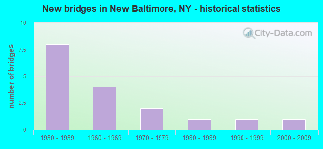
- New bridges - historical statistics
- 81950-1959
- 41960-1969
- 21970-1979
- 11980-1989
- 11990-1999
- 12000-2009

- Reconstructed bridges - Historical Statistics
- 11990-1999
- 02000-2009
- 12010-2019


- Bridge Condition - Deck
- 9.1%Excellent
- 18.2%Very good
- 9.1%Good
- 36.4%Satisfactory
- 27.3%Fair

- Bridge Condition - Superstructure
- 16.7%Excellent
- 41.7%Good
- 33.3%Satisfactory
- 8.3%Fair

- Bridge Condition - Substructure
- 8.3%Excellent
- 41.7%Good
- 25.0%Satisfactory
- 25.0%Fair

- Bridge Condition - Channel
- 40.0%Good
- 60.0%Satisfactory
Find on map >> Show street view
Structure Number: 100754, Location: 1.2 MI N JCT RTS 9W & 144 (Lat: 42.441908, Lng: -73.813717), Route carried "on" structure: US 9W, Year Built: 1995, Status: Open, Structure Length: 2.96m (9.71ft), Average Daily Traffic: 6,346 (year 2020), Truck Traffic: 11%, Average Future Daily Traffic: 7,110 (year 2040), Design Load: HS 25 or greater, Features Intersected: HANNACROIX CREEK
Minimum Vertical Clearance: 30+ m (98+ ft), Kilometerpoint: 36.894, Lanes on structure: 2, Base Highway Network: Yes, Owner: State Highway Agency, Approaching Roadway Width: 14.3m (46.9ft), Skew: 3 degrees, Material/Design: Steel, Design/Construction: Stringer/Multi-beam, Number Of Spans In Main Unit: 1, Length of Maximum Span: 28.3m (92.8ft), Curb-To-Curb Width: 14.2m (46.6ft), Out-to-Out Width: 14.8m (48.6ft)
Condition: Deck: Very good, Superstructure: Good, Substructure: Good, Channel: Satisfactory, Operating Rating: 81.6 metric tons, Method Used To Determine Operating Rating: Load Factor (LF), Inventory Rating: 42.6 metric tons, Method Used To Determine Inventory Rating: Load Factor (LF), Structural Evaluation: Better than present minimum criteria, Deck Geometry: Superior to present desirable criteria, Waterway Adequacy: Equal to present minimum criteria, Approach Roadway Alignment: Equal to present desirable criteria, Length Of Structure Improvement: 2.95m (9.68ft), Designated Inspection Frequency: Every 24 months, Inspection Date: June 2021, Bridge Improvement Cost: $1,211,000, Roadway Improvement Cost: $709,000, Total Project Cost: $1,921,000 ( Estimate for 2021), Deck Structure Type: Concrete Cast-file-Place, Wearing Surface/Protective System: Wearing Surface: Integral Concrete, Deck Protection: Epoxy Coated Reinforcing
Find on map >> Show street view
Structure Number: 103806, Location: 1.0 MI NE JCT RT 9W & 144 (Lat: 42.433292, Lng: -73.803408), Route carried "on" structure: State highway 144, Year Built: 1952, Status: Open, Structure Length: 11.25m (36.91ft), Average Daily Traffic: 769 (year 2016), Truck Traffic: 8%, Average Future Daily Traffic: 802 (year 2040), Design Load: HS 20+Mod, Features Intersected: I-87 NB, RTE I87
Minimum Vertical Clearance: 30+ m (98+ ft), Kilometerpoint: 1.400, Lanes on structure: 2, Lanes under structure: 4, Base Highway Network: Yes, Owner: State Toll Authority, Maintenance Responsibility: State Highway Agency, Approaching Roadway Width: 9.1m (29.9ft), Skew: 4 degrees, Material/Design: Steel, Design/Construction: Stringer/Multi-beam, Number Of Spans In Main Unit: 4, Length of Maximum Span: 30.8m (101.0ft), Curb-To-Curb Width: 8.9m (29.2ft), Out-to-Out Width: 10.0m (32.8ft)
Condition: Deck: Satisfactory, Superstructure: Good, Substructure: Satisfactory, Operating Rating: 65.3 metric tons, Method Used To Determine Operating Rating: Load Factor (LF), Inventory Rating: 39.0 metric tons, Method Used To Determine Inventory Rating: Load Factor (LF), Structural Evaluation: Equal to present minimum criteria, Deck Geometry: Somewhat better than minimum adequacy, Underclear: High priority of corrective action, Approach Roadway Alignment: Equal to present desirable criteria, Length Of Structure Improvement: 11.24m (36.88ft), Designated Inspection Frequency: Every 24 months, Critical Feature Inspection Frequency: Every 24 months, Inspection Date: April 2020, Critical Feature Inspection Date: April 2020, Bridge Improvement Cost: $2,378,000, Roadway Improvement Cost: $1,392,000, Total Project Cost: $3,770,000 ( Estimate for 2021), Deck Structure Type: Concrete Cast-file-Place, Wearing Surface/Protective System: Wearing Surface: Monolithic Concrete
Find on map >> Show street view
Structure Number: 105355, Location: 1.5 MI N JCT 9W & 81 (Lat: 42.383453, Lng: -73.832919), Route carried "on" structure: US 9W, Year Built: 1954, Status: Open, Structure Length: 9.45m (31.00ft), Average Daily Traffic: 11,061 (year 2016), Truck Traffic: 8%, Average Future Daily Traffic: 11,796 (year 2040), Design Load: HS 20+Mod, Features Intersected: 87IX, RTE I87
Minimum Vertical Clearance: 30+ m (98+ ft), Kilometerpoint: 30.153, Lanes on structure: 2, Lanes under structure: 4, Base Highway Network: Yes, Owner: State Toll Authority, Approaching Roadway Width: 16.0m (52.5ft), Skew: 24 degrees, Material/Design: Steel, Design/Construction: Stringer/Multi-beam, Number Of Spans In Main Unit: 4, Length of Maximum Span: 26.2m (86.0ft), Curb-To-Curb Width: 16.9m (55.4ft), Out-to-Out Width: 17.8m (58.4ft)
Condition: Deck: Satisfactory, Superstructure: Satisfactory, Substructure: Good, Operating Rating: 62.6 metric tons, Method Used To Determine Operating Rating: Load Factor (LF), Inventory Rating: 37.2 metric tons, Method Used To Determine Inventory Rating: Load Factor (LF), Structural Evaluation: Equal to present minimum criteria, Deck Geometry: Superior to present desirable criteria, Underclear: High priority of corrective action, Approach Roadway Alignment: Equal to present desirable criteria, Length Of Structure Improvement: 9.44m (30.97ft), Designated Inspection Frequency: Every 24 months, Inspection Date: June 2020, Bridge Improvement Cost: $3,619,000, Roadway Improvement Cost: $2,119,000, Total Project Cost: $5,738,000 ( Estimate for 2021), Deck Structure Type: Concrete Cast-file-Place, Wearing Surface/Protective System: Wearing Surface: Integral Concrete
Find on map >> Show street view
Structure Number: 320133, Location: 1.5 MI W NEW BALTIMORE (Lat: 42.447519, Lng: -73.814061), Route carried "on" structure: Other road , Year Built: 1981, Status: Open, Structure Length: 4.79m (15.72ft), Average Daily Traffic: 604 (year 2017), Truck Traffic: 3%, Average Future Daily Traffic: 846 (year 2037), Design Load: HS 20, Features Intersected: CSX TRANSPRTATION, Facility Carried by Structure: NEW BALTIMORE RD
Minimum Vertical Clearance: 30+ m (98+ ft), Kilometerpoint: 0.016, Lanes on structure: 2, Owner: Railroad, Maintenance Responsibility: County Highway Agency, Approaching Roadway Width: 10.4m (34.1ft), Skew: 3 degrees, Material/Design: Steel, Design/Construction: Stringer/Multi-beam, Number Of Spans In Main Unit: 1, Length of Maximum Span: 45.7m (149.9ft), Curb-To-Curb Width: 10.5m (34.4ft), Out-to-Out Width: 12.3m (40.4ft)
Condition: Deck: Good, Superstructure: Good, Substructure: Good, Inventory Rating: 78.9 metric tons, Method Used To Determine Inventory Rating: Load Factor (LF), Structural Evaluation: Better than present minimum criteria, Deck Geometry: Equal to present minimum criteria, Underclear: Somewhat better than minimum adequacy, Approach Roadway Alignment: Equal to present desirable criteria, Length Of Structure Improvement: 4.78m (15.68ft), Designated Inspection Frequency: Every 24 months, Inspection Date: August 2021, Bridge Improvement Cost: $1,846,000, Roadway Improvement Cost: $1,081,000, Total Project Cost: $2,928,000 ( Estimate for 2021), Deck Structure Type: Concrete Cast-file-Place, Wearing Surface/Protective System: Wearing Surface: Integral Concrete, Deck Protection: Epoxy Coated Reinforcing
Find on map >> Show street view
Structure Number: 320134, Location: 1 MI W NEW BALTIMORE (Lat: 42.444925, Lng: -73.807411), Route carried "on" structure: County highway , Year Built: 2009, Status: Open, Structure Length: 1.86m (6.10ft), Average Daily Traffic: 604 (year 2017), Truck Traffic: 3%, Average Future Daily Traffic: 846 (year 2037), Design Load: HS 25 or greater, Features Intersected: HANNACROIS CREEK, Facility Carried by Structure: NEW BALTIMORE RD
Minimum Vertical Clearance: 30+ m (98+ ft), Kilometerpoint: 0.740, Lanes on structure: 2, Owner: County Highway Agency, Approaching Roadway Width: 8.5m (27.9ft), Material/Design: Concrete, Design/Construction: Arch - Deck, Number Of Spans In Main Unit: 1, Length of Maximum Span: 18.3m (60.0ft), Curb-To-Curb Width: 8.5m (27.9ft), Out-to-Out Width: 9.5m (31.2ft)
Condition: Deck: Very good, Superstructure: Excellent, Substructure: Excellent, Channel: Satisfactory, Inventory Rating: 68.9 metric tons, Method Used To Determine Inventory Rating: Load Factor (LF), Structural Evaluation: Superior to present desirable criteria, Deck Geometry: Somewhat better than minimum adequacy, Waterway Adequacy: Equal to present desirable criteria, Approach Roadway Alignment: Equal to present minimum criteria, Length Of Structure Improvement: 1.85m (6.07ft), Designated Inspection Frequency: Every 24 months, Inspection Date: March 2020, Bridge Improvement Cost: $744,000, Roadway Improvement Cost: $436,000, Total Project Cost: $1,180,000 ( Estimate for 2021), Deck Structure Type: Concrete Cast-file-Place, Wearing Surface/Protective System: Wearing Surface: Integral Concrete, Deck Protection: Epoxy Coated Reinforcing
Find on map >> Show street view
Structure Number: 320135, Location: 2 MI NW NEW BALTIMORE (Lat: 42.450836, Lng: -73.830947), Route carried "on" structure: Other road , Year Built: 1961, Year Reconstructed: 2016, Status: Open, Structure Length: 2.13m (6.99ft), Average Daily Traffic: 244 (year 2017), Truck Traffic: 6%, Average Future Daily Traffic: 342 (year 2037), Design Load: HL 93, Features Intersected: HANNACROIS CREEK, Facility Carried by Structure: DEANS MILL ROAD
Minimum Vertical Clearance: 30+ m (98+ ft), Kilometerpoint: 3.315, Lanes on structure: 2, Owner: County Highway Agency, Approaching Roadway Width: 6.1m (20.0ft), Material/Design: Prestressed concrete, Design/Construction: Box Beam or Girders - Multiple, Number Of Spans In Main Unit: 1, Length of Maximum Span: 20.7m (67.9ft), Curb-To-Curb Width: 6.3m (20.7ft), Out-to-Out Width: 7.4m (24.3ft)
Condition: Deck: Excellent, Superstructure: Excellent, Substructure: Good, Channel: Good, Operating Rating: 60.6 metric tons, Method Used To Determine Operating Rating: Load and Resistance Factor Rating (LRFR) rating reported by rating factor(RF) method using HL-93 loadings, Inventory Rating: 46.7 metric tons, Method Used To Determine Inventory Rating: Load and Resistance Factor Rating (LRFR) rating reported by rating factor(RF) method using HL-93 loadings, Structural Evaluation: Better than present minimum criteria, Deck Geometry: Meets minimum limits, Waterway Adequacy: Meets minimum limits, Approach Roadway Alignment: Meets minimum limits, Length Of Structure Improvement: 2.13m (6.99ft), Designated Inspection Frequency: Every 24 months, Inspection Date: September 2020, Bridge Improvement Cost: $453,000, Roadway Improvement Cost: $266,000, Total Project Cost: $719,000 ( Estimate for 2021), Wearing Surface/Protective System: Wearing Surface: Bituminous
Find on map >> Show street view
Structure Number: 330291, Location: 1 MI N VILLAGE COXSACKIE (Lat: 42.380519, Lng: -73.809719), Route carried "on" structure: County highway , Year Built: 1968, Status: Posted for load, Structure Length: 1.86m (6.10ft), Average Daily Traffic: 372 (year 2016), Truck Traffic: 7%, Average Future Daily Traffic: 521 (year 2036), Features Intersected: COXSACKIE CREEK, Facility Carried by Structure: RIVER ROAD
Minimum Vertical Clearance: 30+ m (98+ ft), Kilometerpoint: 1.657, Lanes on structure: 2, Owner: County Highway Agency, Approaching Roadway Width: 6.7m (22.0ft), Material/Design: Prestressed concrete, Design/Construction: Tee Beam, Number Of Spans In Main Unit: 1, Length of Maximum Span: 17.3m (56.8ft), Curb-To-Curb Width: 6.8m (22.3ft), Out-to-Out Width: 7.4m (24.3ft)
Condition: Deck: Satisfactory, Superstructure: Fair, Substructure: Satisfactory, Channel: Satisfactory, Operating Rating: 18.1 metric tons, Method Used To Determine Operating Rating: Field evaluation and documented engineering judgment, Inventory Rating: 18.1 metric tons, Method Used To Determine Inventory Rating: Field evaluation and documented engineering judgment, Structural Evaluation: Somewhat better than minimum adequacy, Deck Geometry: Meets minimum limits, Waterway Adequacy: Equal to present desirable criteria, Approach Roadway Alignment: Somewhat better than minimum adequacy, Bridge Posting: Required (Relationship of Operating Rating to Maximum Legal Load: > 39.9% below), Length Of Structure Improvement: 1.85m (6.07ft), Designated Inspection Frequency: Every 12 months, Inspection Date: April 2021, Bridge Improvement Cost: $468,000, Roadway Improvement Cost: $274,000, Total Project Cost: $743,000 ( Estimate for 2021), Deck Structure Type: Other, Wearing Surface/Protective System: Wearing Surface: Bituminous
Find on map >> Show street view
Structure Number: 5513279, Location: NYS THRUWAY EXIT 21B (Lat: 42.393650, Lng: -73.824789), Route carried "on" structure: Ramp Other road , Year Built: 1972, Year Reconstructed: 1998, Status: Open, Structure Length: 6.25m (20.51ft), Average Daily Traffic: 1,808 (year 2018), Truck Traffic: 27%, Average Future Daily Traffic: 2,153 (year 2040), Design Load: HS 20+Mod, Features Intersected: 87IX SB, RTE I87, Facility Carried by Structure: NYSTA EXIT 21B
Minimum Vertical Clearance: 30+ m (98+ ft), Kilometerpoint: 0.322, Lanes on structure: 2, Lanes under structure: 5, Toll: On Interstate toll segment, Owner: State Toll Authority, Approaching Roadway Width: 17.7m (58.1ft), Skew: 30 degrees, Material/Design: Steel, Design/Construction: Stringer/Multi-beam, Number Of Spans In Main Unit: 2, Length of Maximum Span: 30.5m (100.1ft), Curb-To-Curb Width: 17.4m (57.1ft), Out-to-Out Width: 18.3m (60.0ft)
Condition: Deck: Fair, Superstructure: Good, Substructure: Satisfactory, Operating Rating: 48.9 metric tons, Method Used To Determine Operating Rating: Load and Resistance Factor Rating (LRFR) rating reported by rating factor(RF) method using HL-93 loadings, Inventory Rating: 37.6 metric tons, Method Used To Determine Inventory Rating: Load and Resistance Factor Rating (LRFR) rating reported by rating factor(RF) method using HL-93 loadings, Structural Evaluation: Equal to present minimum criteria, Deck Geometry: Superior to present desirable criteria, Underclear: Meets minimum limits, Approach Roadway Alignment: Equal to present desirable criteria, Length Of Structure Improvement: 6.24m (20.47ft), Designated Inspection Frequency: Every 24 months, Inspection Date: March 2020, Bridge Improvement Cost: $2,798,000, Roadway Improvement Cost: $1,639,000, Total Project Cost: $4,437,000 ( Estimate for 2021), Deck Structure Type: Concrete Cast-file-Place, Wearing Surface/Protective System: Wearing Surface: Integral Concrete
Find on map >> Show street view
Structure Number: 5513289, Location: 3 MI N VILLAGE COXSACKIE (Lat: 42.405636, Lng: -73.818567), Route carried "on" structure: Interstate 87, Year Built: 1955, Status: Open, Structure Length: 8.96m (29.40ft), Average Daily Traffic: 29,892 (year 2020), Truck Traffic: 25%, Average Future Daily Traffic: 35,601 (year 2040), Design Load: HS 20+Mod, Features Intersected: CSX TRANSPORTATIO
Minimum Vertical Clearance: 30+ m (98+ ft), Kilometerpoint: 31.520, Lanes on structure: 4, Base Highway Network: Yes, Toll: On Interstate toll segment, Owner: State Toll Authority, Approaching Roadway Width: 32.3m (106.0ft), Skew: 25 degrees, Material/Design: Steel continuous, Design/Construction: Stringer/Multi-beam, Number Of Spans In Main Unit: 3, Length of Maximum Span: 33.5m (109.9ft), Curb-To-Curb Width: 33.6m (110.2ft), Out-to-Out Width: 34.5m (113.2ft)
Condition: Deck: Satisfactory, Superstructure: Good, Substructure: Fair, Operating Rating: 37.6 metric tons, Method Used To Determine Operating Rating: Load and Resistance Factor Rating (LRFR) rating reported by rating factor(RF) method using HL-93 loadings, Inventory Rating: 28.8 metric tons, Method Used To Determine Inventory Rating: Load and Resistance Factor Rating (LRFR) rating reported by rating factor(RF) method using HL-93 loadings, Structural Evaluation: Somewhat better than minimum adequacy, Deck Geometry: Superior to present desirable criteria, Underclear: Somewhat better than minimum adequacy, Approach Roadway Alignment: Equal to present desirable criteria, Length Of Structure Improvement: 8.96m (29.40ft), Designated Inspection Frequency: Every 24 months, Inspection Date: December 2021, Bridge Improvement Cost: $7,000,000, Roadway Improvement Cost: $4,099,000, Total Project Cost: $11,100,000 ( Estimate for 2021), Deck Structure Type: Concrete Cast-file-Place, Wearing Surface/Protective System: Wearing Surface: Latex Concrete
Find on map >> Show street view
Structure Number: 551329, Location: 1.5 MI SW OF NEW BALTIMOR (Lat: 42.429822, Lng: -73.803619), Route carried "on" structure: Ramp Interstate , Year Built: 1964, Status: Open, Structure Length: 6.22m (20.41ft), Truck Traffic: 10%, Design Load: HS 20+Mod, Features Intersected: 87IX NB, RTE I87, Facility Carried by Structure: NEW BALT SER RD
Minimum Vertical Clearance: 30+ m (98+ ft), Kilometerpoint: 0.000, Lanes on structure: 2, Lanes under structure: 6, Toll: On Interstate toll segment, Owner: State Toll Authority, Approaching Roadway Width: 11.6m (38.1ft), Skew: 20 degrees, Material/Design: Steel, Design/Construction: Stringer/Multi-beam, Number Of Spans In Main Unit: 2, Length of Maximum Span: 30.5m (100.1ft), Curb or Sidewalk Widths: Left: 0.4m (1.3ft), Right: 0.4m (1.3ft), Curb-To-Curb Width: 11.0m (36.1ft), Out-to-Out Width: 12.6m (41.3ft)
Condition: Deck: Fair, Superstructure: Satisfactory, Substructure: Fair, Operating Rating: 53.8 metric tons, Method Used To Determine Operating Rating: Load and Resistance Factor Rating (LRFR) rating reported by rating factor(RF) method using HL-93 loadings, Inventory Rating: 41.5 metric tons, Method Used To Determine Inventory Rating: Load and Resistance Factor Rating (LRFR) rating reported by rating factor(RF) method using HL-93 loadings, Structural Evaluation: Somewhat better than minimum adequacy, Deck Geometry: Better than present minimum criteria, Underclear: High priority of corrective action, Approach Roadway Alignment: Equal to present desirable criteria, Length Of Structure Improvement: 6.21m (20.37ft), Designated Inspection Frequency: Every 24 months, Inspection Date: March 2020, Bridge Improvement Cost: $1,670,000, Roadway Improvement Cost: $978,000, Total Project Cost: $2,647,000 ( Estimate for 2021), Deck Structure Type: Concrete Cast-file-Place, Wearing Surface/Protective System: Wearing Surface: Integral Concrete
Find on map >> Show street view
Structure Number: 5513309, Location: 1 MI NE JCT SH144 & US 9W (Lat: 42.440656, Lng: -73.806114), Route carried "on" structure: Interstate 87, Year Built: 1955, Status: Open, Structure Length: 1.98m (6.50ft), Average Daily Traffic: 29,892 (year 2020), Truck Traffic: 25%, Average Future Daily Traffic: 35,601 (year 2040), Design Load: HS 20+Mod, Features Intersected: HANNACROIS CREEK
Minimum Vertical Clearance: 30+ m (98+ ft), Kilometerpoint: 35.832, Lanes on structure: 4, Base Highway Network: Yes, Toll: On Interstate toll segment, Owner: State Toll Authority, Approaching Roadway Width: 39.0m (128.0ft), Skew: 20 degrees, Material/Design: Steel, Design/Construction: Stringer/Multi-beam, Number Of Spans In Main Unit: 1, Length of Maximum Span: 18.9m (62.0ft), Curb-To-Curb Width: 31.7m (104.0ft), Out-to-Out Width: 37.5m (123.0ft)
Condition: Deck: Fair, Superstructure: Satisfactory, Substructure: Fair, Channel: Good, Operating Rating: 62.9 metric tons, Method Used To Determine Operating Rating: Load and Resistance Factor Rating (LRFR) rating reported by rating factor(RF) method using HL-93 loadings, Inventory Rating: 48.3 metric tons, Method Used To Determine Inventory Rating: Load and Resistance Factor Rating (LRFR) rating reported by rating factor(RF) method using HL-93 loadings, Structural Evaluation: Somewhat better than minimum adequacy, Deck Geometry: Superior to present desirable criteria, Waterway Adequacy: Superior to present desirable criteria, Approach Roadway Alignment: Equal to present desirable criteria, Length Of Structure Improvement: 1.98m (6.50ft), Designated Inspection Frequency: Every 24 months, Inspection Date: August 2020, Bridge Improvement Cost: $2,552,000, Roadway Improvement Cost: $1,494,000, Total Project Cost: $4,046,000 ( Estimate for 2021), Deck Structure Type: Concrete Cast-file-Place, Wearing Surface/Protective System: Wearing Surface: Bituminous
Find on map >> Show street view
Structure Number: 5513319, Location: 1 MI W NEW BALTIMORE (Lat: 42.445464, Lng: -73.809411), Route carried "on" structure: Interstate 87, Year Built: 1952, Status: Open, Structure Length: 1.25m (4.10ft), Average Daily Traffic: 29,892 (year 2020), Truck Traffic: 25%, Average Future Daily Traffic: 35,601 (year 2040), Design Load: HS 20+Mod, Features Intersected: NEW BALTIMORE RD
Minimum Vertical Clearance: 30+ m (98+ ft), Kilometerpoint: 36.396, Lanes on structure: 4, Lanes under structure: 2, Base Highway Network: Yes, Toll: On Interstate toll segment, Owner: State Toll Authority, Approaching Roadway Width: 23.5m (77.1ft), Skew: 34 degrees, Material/Design: Concrete, Design/Construction: Frame, Number Of Spans In Main Unit: 1, Length of Maximum Span: 12.5m (41.0ft), Curb-To-Curb Width: 38.1m (125.0ft), Out-to-Out Width: 46.7m (153.2ft)
Condition: Superstructure: Satisfactory, Substructure: Good, Operating Rating: 81.5 metric tons, Method Used To Determine Operating Rating: Field evaluation and documented engineering judgment, Inventory Rating: 32.7 metric tons, Method Used To Determine Inventory Rating: Field evaluation and documented engineering judgment, Structural Evaluation: Equal to present minimum criteria, Deck Geometry: Superior to present desirable criteria, Underclear: High priority of corrective action, Approach Roadway Alignment: Equal to present desirable criteria, Length Of Structure Improvement: 1.24m (4.07ft), Designated Inspection Frequency: Every 24 months, Inspection Date: June 2020, Bridge Improvement Cost: $4,002,000, Roadway Improvement Cost: $2,343,000, Total Project Cost: $6,345,000 ( Estimate for 2021), Wearing Surface/Protective System: Wearing Surface: Bituminous
Find on map >> Show street view
Structure Number: 103806, Location: 1.0 MI NE JCT RT 9W & 144 (Lat: 42.433292, Lng: -73.803408), Route carried "under" structure: Interstate 87, Year Built: 1952, Structure Length: 0. m, Average Daily Traffic: 38,143 (year 2014), Features Intersected: I-87 NB, RTE I87, Facility Carried by Structure: RTE 144
Minimum Vertical Clearance: 4.72m (15.49ft), Kilometerpoint: 205.244, Lanes on structure: 2, Lanes under structure: 2, Toll: On toll road, Material/Design: Steel, Design/Construction: Stringer/Multi-beam, Length of Maximum Span: 30.8m (101.0ft)
Find on map >> Show street view
Structure Number: 105355, Location: 1.5 MI N JCT 9W & 81 (Lat: 42.383453, Lng: -73.832919), Route carried "under" structure: Interstate 87, Year Built: 1954, Structure Length: 0. m, Average Daily Traffic: 34,985 (year 2014), Features Intersected: 87IX, RTE I87, Facility Carried by Structure: RTE 9W
Minimum Vertical Clearance: 4.95m (16.24ft), Kilometerpoint: 199.017, Lanes on structure: 2, Lanes under structure: 2, Toll: On Interstate toll segment, Material/Design: Steel, Design/Construction: Stringer/Multi-beam, Length of Maximum Span: 26.2m (86.0ft)
Find on map >> Show street view
Structure Number: 5513279, Location: NYS THRUWAY EXIT 21B (Lat: 42.393650, Lng: -73.824789), Route carried "under" structure: Interstate 87, Year Built: 1972, Structure Length: 0. m, Average Daily Traffic: 38,143 (year 2014), Features Intersected: 87IX SB, RTE I87, Facility Carried by Structure: NYSTA EXIT 21B
Minimum Vertical Clearance: 5.21m (17.09ft), Kilometerpoint: 200.369, Lanes on structure: 2, Lanes under structure: 3, Toll: On Interstate toll segment, Material/Design: Steel, Design/Construction: Stringer/Multi-beam, Length of Maximum Span: 30.5m (100.1ft)
Find on map >> Show street view
Structure Number: 551329, Location: 1.5 MI SW OF NEW BALTIMOR (Lat: 42.429822, Lng: -73.803619), Route carried "under" structure: Interstate 87, Year Built: 1964, Structure Length: 0. m, Average Daily Traffic: 17,806 (year 2014), Features Intersected: 87IX NB, RTE I87, Facility Carried by Structure: NEW BALT SER RD
Minimum Vertical Clearance: 4.65m (15.26ft), Kilometerpoint: 204.794, Lanes on structure: 2, Lanes under structure: 3, Toll: On Interstate toll segment, Material/Design: Steel, Design/Construction: Stringer/Multi-beam, Length of Maximum Span: 30.5m (100.1ft)
Find on map >> Show street view
Structure Number: 5513319, Location: 1 MI W NEW BALTIMORE (Lat: 42.445464, Lng: -73.809411), Route carried "under" structure: Other road , Year Built: 1952, Structure Length: 0. m, Average Daily Traffic: 604 (year 2017), Truck Traffic: 3%, Features Intersected: NEW BALTIMORE RD, Facility Carried by Structure: RTE I87
Minimum Vertical Clearance: 4.42m (14.50ft), Kilometerpoint: 0.499, Lanes on structure: 4, Lanes under structure: 2, Material/Design: Concrete, Design/Construction: Frame, Length of Maximum Span: 12.5m (41.0ft)