Bridge Statistics for New Baltimore, Virginia (VA)
Condition, Traffic, Stress, Structural Evaluation, Project Costs
- National Bridge Inventory (NBI) Statistics
- 14Number of bridges
- 59ft / 17.6mTotal length
- $75,000Total costs
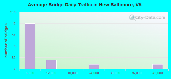
- 91,985Total average daily traffic
- 4,295Total average daily truck traffic
- National Bridge Inventory (NBI) Registered Bridges for New Baltimore
- No street view available for this location
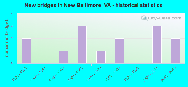
- New bridges - historical statistics
- 21930-1939
- 11950-1959
- 31960-1969
- 11970-1979
- 21980-1989
- 32000-2009
- 22010-2019
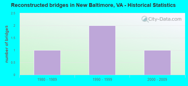
- Reconstructed bridges - Historical Statistics
- 11980-1989
- 21990-1999
- 12000-2009
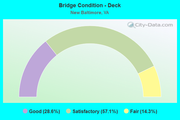
- Bridge Condition - Deck
- 28.6%Good
- 57.1%Satisfactory
- 14.3%Fair
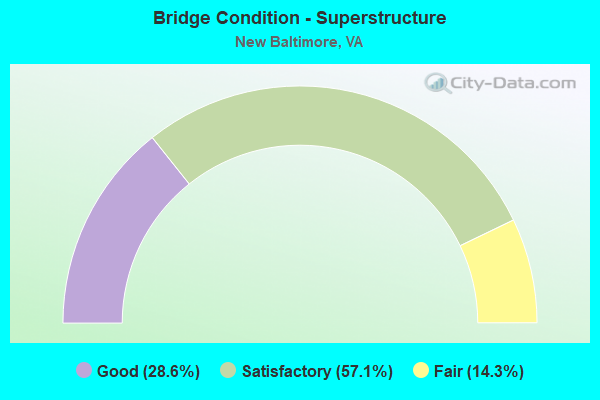
- Bridge Condition - Superstructure
- 28.6%Good
- 57.1%Satisfactory
- 14.3%Fair
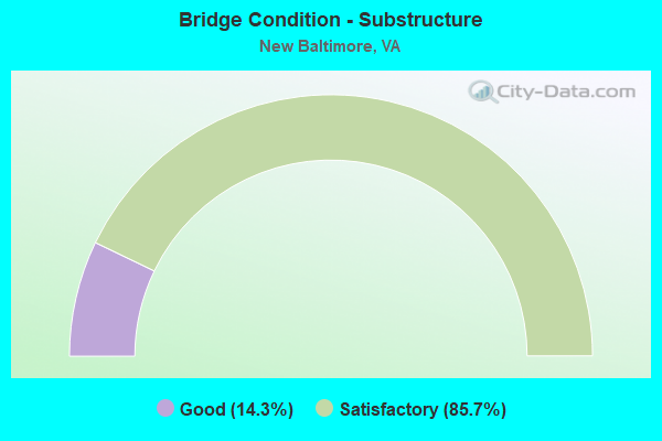
- Bridge Condition - Substructure
- 14.3%Good
- 85.7%Satisfactory
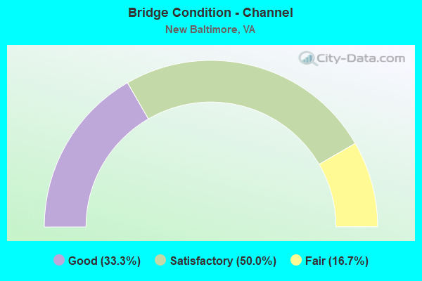
- Bridge Condition - Channel
- 33.3%Good
- 50.0%Satisfactory
- 16.7%Fair
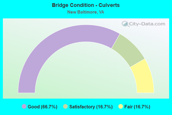
- Bridge Condition - Culverts
- 66.7%Good
- 16.7%Satisfactory
- 16.7%Fair
Find on map >> Show street view
Structure Number: 7114, Location: .75 Fr 605 & .25 To 673 (Lat: 38.747461, Lng: -77.753711), Route carried "on" structure: US 15, Year Built: 1954, Status: Open, Structure Length: 0.69m (2.26ft), Average Daily Traffic: 23,825 (year 2020), Truck Traffic: 4%, Average Future Daily Traffic: 33,356 (year 2040), Design Load: HS 20, Features Intersected: West Fork Mill Run, Facility Carried by Structure: Lee Highway SBL
Minimum Vertical Clearance: 30+ m (98+ ft), Kilometerpoint: 335.477, Lanes on structure: 2, Base Highway Network: Yes, Owner: State Highway Agency, Approaching Roadway Width: 9.4m (30.8ft), Material/Design: Concrete, Design/Construction: Slab, Number Of Spans In Main Unit: 1, Length of Maximum Span: 6.1m (20.0ft), Curb or Sidewalk Widths: Left: 0.2m (0.7ft), Right: 0.2m (0.7ft), Curb-To-Curb Width: 12.2m (40.0ft), Out-to-Out Width: 12.8m (42.0ft)
Condition: Deck: Satisfactory, Superstructure: Satisfactory, Substructure: Satisfactory, Channel: Satisfactory, Operating Rating: 49.0 metric tons, Method Used To Determine Operating Rating: Load Factor (LF), Inventory Rating: 29.0 metric tons, Method Used To Determine Inventory Rating: Load Factor (LF), Structural Evaluation: Equal to present minimum criteria, Deck Geometry: Better than present minimum criteria, Waterway Adequacy: Equal to present desirable criteria, Approach Roadway Alignment: Equal to present desirable criteria, Designated Inspection Frequency: Every 24 months, Inspection Date: May 2021, Deck Structure Type: Concrete Cast-file-Place, Wearing Surface/Protective System: Wearing Surface: Bituminous
Find on map >> Show street view
Structure Number: 7239, Location: .64 Fr 55 & .72 Pr Wm Co (Lat: 38.826353, Lng: -77.722947), Route carried "on" structure: Interstate 66, Year Built: 1980, Status: Open, Structure Length: 3.17m (10.40ft), Average Daily Traffic: 37,827 (year 2020), Truck Traffic: 8%, Average Future Daily Traffic: 52,958 (year 2040), Design Load: HS 20+Mod, Features Intersected: Route 628
Minimum Vertical Clearance: 30+ m (98+ ft), Kilometerpoint: 57.554, Lanes on structure: 4, Lanes under structure: 2, Base Highway Network: Yes, Owner: State Highway Agency, Approaching Roadway Width: 25.9m (85.0ft), Material/Design: Steel, Design/Construction: Stringer/Multi-beam, Number Of Spans In Main Unit: 3, Length of Maximum Span: 11.9m (39.0ft), Curb-To-Curb Width: 26.2m (86.0ft), Out-to-Out Width: 28.0m (91.9ft)
Condition: Deck: Satisfactory, Superstructure: Satisfactory, Substructure: Satisfactory, Operating Rating: 67.1 metric tons, Method Used To Determine Operating Rating: Load and Resistance Factor (LRFR), Inventory Rating: 51.7 metric tons, Method Used To Determine Inventory Rating: Load and Resistance Factor (LRFR), Structural Evaluation: Equal to present minimum criteria, Deck Geometry: Superior to present desirable criteria, Underclear: Meets minimum limits, Approach Roadway Alignment: Equal to present desirable criteria, Designated Inspection Frequency: Every 24 months, Inspection Date: September 2020, Deck Structure Type: Concrete Cast-file-Place
Find on map >> Show street view
Structure Number: 7263, Location: .01 Fr 670S & .06 To 670N (Lat: 38.702231, Lng: -77.701869), Route carried "on" structure: County highway 602, Year Built: 1967, Year Reconstructed: 2002, Status: Open, Structure Length: 2.93m (9.61ft), Average Daily Traffic: 1,173 (year 2020), Average Future Daily Traffic: 1,639 (year 2040), Design Load: HS 20, Features Intersected: Cedar Run, Facility Carried by Structure: Rogues road
Minimum Vertical Clearance: 30+ m (98+ ft), Kilometerpoint: 23.720, Lanes on structure: 2, Owner: State Highway Agency, Approaching Roadway Width: 7.9m (25.9ft), Material/Design: Concrete, Design/Construction: Slab, Number Of Spans In Main Unit: 3, Length of Maximum Span: 9.8m (32.2ft), Curb-To-Curb Width: 8.5m (27.9ft), Out-to-Out Width: 9.1m (29.9ft)
Condition: Deck: Satisfactory, Superstructure: Satisfactory, Substructure: Good, Channel: Good, Operating Rating: 38.1 metric tons, Method Used To Determine Operating Rating: Load and Resistance Factor (LRFR), Inventory Rating: 29.0 metric tons, Method Used To Determine Inventory Rating: Load and Resistance Factor (LRFR), Structural Evaluation: Equal to present minimum criteria, Deck Geometry: Somewhat better than minimum adequacy, Waterway Adequacy: Equal to present minimum criteria, Approach Roadway Alignment: Equal to present desirable criteria, Designated Inspection Frequency: Every 24 months, Inspection Date: September 2020, Deck Structure Type: Concrete Cast-file-Place, Wearing Surface/Protective System: Wearing Surface: Epoxy Overlay
Find on map >> Show street view
Structure Number: 7265, Location: .22 Fr 652 & .70 To 761 (Lat: 38.724914, Lng: -77.661481), Route carried "on" structure: County highway 603, Year Built: 1937, Status: Open, Structure Length: 0.69m (2.26ft), Average Daily Traffic: 2,576 (year 2020), Truck Traffic: 2%, Average Future Daily Traffic: 3,445 (year 2040), Design Load: HS 20, Features Intersected: Kettle Run, Facility Carried by Structure: Greenwich Road
Minimum Vertical Clearance: 30+ m (98+ ft), Kilometerpoint: 10.484, Lanes on structure: 2, Owner: State Highway Agency, Approaching Roadway Width: 6.4m (21.0ft), Material/Design: Concrete, Design/Construction: Slab, Number Of Spans In Main Unit: 1, Length of Maximum Span: 6.1m (20.0ft), Curb or Sidewalk Widths: Left: 0.2m (0.7ft), Right: 0.2m (0.7ft), Curb-To-Curb Width: 7.0m (23.0ft), Out-to-Out Width: 7.8m (25.6ft)
Condition: Deck: Fair, Superstructure: Fair, Substructure: Satisfactory, Channel: Satisfactory, Operating Rating: 41.7 metric tons, Method Used To Determine Operating Rating: Load and Resistance Factor (LRFR), Inventory Rating: 24.5 metric tons, Method Used To Determine Inventory Rating: Load and Resistance Factor (LRFR), Structural Evaluation: Somewhat better than minimum adequacy, Deck Geometry: High priority of replacement, Waterway Adequacy: Better than present minimum criteria, Approach Roadway Alignment: Equal to present desirable criteria, Length Of Structure Improvement: 0.91m (2.99ft), Designated Inspection Frequency: Every 24 months, Inspection Date: August 2020, Bridge Improvement Cost: $50,000, Roadway Improvement Cost: $10,000, Total Project Cost: $75,000, Deck Structure Type: Concrete Cast-file-Place, Wearing Surface/Protective System: Wearing Surface: Bituminous
Find on map >> Show street view
Structure Number: 7293, Location: .18 Fr 15/29 & .52 To End (Lat: 38.776761, Lng: -77.691572), Route carried "on" structure: County highway 625, Year Built: 1930, Year Reconstructed: 1987, Status: Open, Structure Length: 0.73m (2.40ft), Average Daily Traffic: 580 (year 2015), Average Future Daily Traffic: 649 (year 2040), Design Load: HS 20, Features Intersected: Branch Broad Run, Facility Carried by Structure: Pilgrims Rest Rd E
Minimum Vertical Clearance: 30+ m (98+ ft), Kilometerpoint: 0.290, Lanes on structure: 2, Owner: State Highway Agency, Approaching Roadway Width: 5.5m (18.0ft), Material/Design: Concrete, Design/Construction: Slab, Number Of Spans In Main Unit: 1, Length of Maximum Span: 6.7m (22.0ft), Curb-To-Curb Width: 8.5m (27.9ft), Out-to-Out Width: 9.5m (31.2ft)
Condition: Deck: Good, Superstructure: Good, Substructure: Satisfactory, Channel: Satisfactory, Operating Rating: 87.1 metric tons, Method Used To Determine Operating Rating: Load and Resistance Factor (LRFR), Inventory Rating: 67.1 metric tons, Method Used To Determine Inventory Rating: Load and Resistance Factor (LRFR), Structural Evaluation: Equal to present minimum criteria, Deck Geometry: Somewhat better than minimum adequacy, Waterway Adequacy: Equal to present minimum criteria, Approach Roadway Alignment: Equal to present desirable criteria, Designated Inspection Frequency: Every 24 months, Inspection Date: November 2020, Deck Structure Type: Concrete Precast Panels, Wearing Surface/Protective System: Wearing Surface: Bituminous, Membrane: Epoxy, Deck Protection: Epoxy Coated Reinforcing
Find on map >> Show street view
Structure Number: 7355, Location: .38 Fr 600 & 2.05 To 605 (Lat: 38.755153, Lng: -77.701392), Route carried "on" structure: County highway 676, Year Built: 1968, Year Reconstructed: 1996, Status: Open, Structure Length: 0.90m (2.95ft), Average Daily Traffic: 2,239 (year 2020), Truck Traffic: 1%, Average Future Daily Traffic: 3,135 (year 2040), Design Load: HS 20, Features Intersected: South Run, Facility Carried by Structure: Riley Road
Minimum Vertical Clearance: 30+ m (98+ ft), Kilometerpoint: 3.290, Lanes on structure: 2, Owner: State Highway Agency, Approaching Roadway Width: 6.7m (22.0ft), Material/Design: Concrete, Design/Construction: Slab, Number Of Spans In Main Unit: 1, Length of Maximum Span: 9.0m (29.5ft), Curb-To-Curb Width: 7.6m (24.9ft), Out-to-Out Width: 8.2m (26.9ft)
Condition: Deck: Satisfactory, Superstructure: Satisfactory, Substructure: Satisfactory, Channel: Fair, Operating Rating: 63.5 metric tons, Method Used To Determine Operating Rating: Load Factor (LF), Inventory Rating: 38.1 metric tons, Method Used To Determine Inventory Rating: Load Factor (LF), Structural Evaluation: Equal to present minimum criteria, Deck Geometry: High priority of replacement, Waterway Adequacy: Equal to present minimum criteria, Approach Roadway Alignment: Equal to present desirable criteria, Designated Inspection Frequency: Every 24 months, Inspection Date: September 2020, Deck Structure Type: Concrete Precast Panels, Wearing Surface/Protective System: Wearing Surface: Bituminous, Membrane: Epoxy, Deck Protection: Epoxy Coated Reinforcing
Find on map >> Show street view
Structure Number: 7386, Location: .15 Fr 674 & .15 To 829 (Lat: 38.778197, Lng: -77.737353), Route carried "on" structure: County highway 694, Year Built: 1970, Status: Open, Structure Length: 0.64m (2.10ft), Average Daily Traffic: 1,124 (year 2015), Average Future Daily Traffic: 1,436 (year 2040), Design Load: HS 20, Features Intersected: South Run, Facility Carried by Structure: Old Bust Head Road
Minimum Vertical Clearance: 30+ m (98+ ft), Kilometerpoint: 4.581, Lanes on structure: 2, Owner: State Highway Agency, Approaching Roadway Width: 6.1m (20.0ft), Material/Design: Steel, Design/Construction: Culvert, Number Of Spans In Main Unit: 3, Length of Maximum Span: 1.8m (5.9ft)
Condition: Channel: Fair, Culverts: Fair, Operating Rating: 44.5 metric tons, Method Used To Determine Operating Rating: Field evaluation and documented engineering judgment, Inventory Rating: 32.7 metric tons, Method Used To Determine Inventory Rating: Field evaluation and documented engineering judgment, Structural Evaluation: Somewhat better than minimum adequacy, Waterway Adequacy: Somewhat better than minimum adequacy, Approach Roadway Alignment: Better than present minimum criteria, Designated Inspection Frequency: Every 24 months, Inspection Date: November 2020
Find on map >> Show street view
Structure Number: 7437, Location: .83 Fr 603S &.27 To 603N (Lat: 38.724775, Lng: -77.663053), Route carried "on" structure: County highway 761, Year Built: 1961, Year Reconstructed: 2009, Status: Open, Structure Length: 0.73m (2.40ft), Average Daily Traffic: 22 (year 2015), Average Future Daily Traffic: 25 (year 2040), Design Load: HS 20, Features Intersected: Kettle Run, Facility Carried by Structure: Greenville Road
Minimum Vertical Clearance: 30+ m (98+ ft), Kilometerpoint: 0.267, Lanes on structure: 1, Owner: State Highway Agency, Approaching Roadway Width: 4.0m (13.1ft), Material/Design: Steel, Design/Construction: Stringer/Multi-beam, Number Of Spans In Main Unit: 1, Length of Maximum Span: 6.4m (21.0ft), Curb-To-Curb Width: 4.1m (13.5ft), Out-to-Out Width: 4.6m (15.1ft)
Condition: Deck: Good, Superstructure: Good, Substructure: Satisfactory, Channel: Good, Operating Rating: 66.2 metric tons, Method Used To Determine Operating Rating: Load and Resistance Factor (LRFR), Inventory Rating: 50.8 metric tons, Method Used To Determine Inventory Rating: Load and Resistance Factor (LRFR), Structural Evaluation: Equal to present minimum criteria, Deck Geometry: Somewhat better than minimum adequacy, Waterway Adequacy: Equal to present minimum criteria, Approach Roadway Alignment: Equal to present desirable criteria, Designated Inspection Frequency: Every 24 months, Inspection Date: August 2021, Deck Structure Type: Wood or Timber, Wearing Surface/Protective System: Wearing Surface: Bituminous
Find on map >> Show street view
Structure Number: 26336, Location: .25 Fr 15/29 & .62 To 600 (Lat: 38.768303, Lng: -77.695572), Route carried "on" structure: County highway 676, Year Built: 2000, Status: Open, Structure Length: 1.07m (3.51ft), Average Daily Traffic: 2,771 (year 2020), Truck Traffic: 2%, Average Future Daily Traffic: 3,879 (year 2040), Design Load: HS 20, Features Intersected: Branch Broad Run, Facility Carried by Structure: Riley Road
Minimum Vertical Clearance: 30+ m (98+ ft), Kilometerpoint: 4.907, Lanes on structure: 2, Owner: State Highway Agency, Approaching Roadway Width: 9.1m (29.9ft), Skew: 4 degrees, Material/Design: Concrete, Design/Construction: Culvert, Number Of Spans In Main Unit: 2, Length of Maximum Span: 5.2m (17.1ft)
Condition: Channel: Satisfactory, Culverts: Good, Operating Rating: 76.2 metric tons, Method Used To Determine Operating Rating: Load Factor (LF), Inventory Rating: 45.4 metric tons, Method Used To Determine Inventory Rating: Load Factor (LF), Structural Evaluation: Better than present minimum criteria, Waterway Adequacy: Equal to present desirable criteria, Approach Roadway Alignment: Better than present minimum criteria, Designated Inspection Frequency: Every 24 months, Inspection Date: March 2020
Find on map >> Show street view
Structure Number: 27148, Location: .11 Fr 652 &.45 To PrWmCo (Lat: 38.755111, Lng: -77.673856), Route carried "on" structure: State highway 215, Year Built: 2003, Status: Open, Structure Length: 1.37m (4.49ft), Average Daily Traffic: 9,442 (year 2020), Truck Traffic: 2%, Average Future Daily Traffic: 13,219 (year 2040), Design Load: HS 20, Features Intersected: South Run, Facility Carried by Structure: Vint Hill Road
Minimum Vertical Clearance: 30+ m (98+ ft), Kilometerpoint: 0.000, Lanes on structure: 2, Owner: State Highway Agency, Approaching Roadway Width: 12.2m (40.0ft), Skew: 2 degrees, Material/Design: Concrete, Design/Construction: Culvert, Number Of Spans In Main Unit: 4, Length of Maximum Span: 3.4m (11.2ft)
Condition: Channel: Satisfactory, Culverts: Good, Operating Rating: 89.8 metric tons, Method Used To Determine Operating Rating: Load Factor (LF), Inventory Rating: 65.3 metric tons, Method Used To Determine Inventory Rating: Load Factor (LF), Structural Evaluation: Better than present minimum criteria, Waterway Adequacy: Equal to present desirable criteria, Approach Roadway Alignment: Equal to present desirable criteria, Designated Inspection Frequency: Every 24 months, Inspection Date: May 2021
Find on map >> Show street view
Structure Number: 27827, Location: .37 Fr 1401 & .05 To 674 (Lat: 38.733464, Lng: -77.744744), Route carried "on" structure: County highway 605, Year Built: 2009, Status: Open, Structure Length: 1.16m (3.81ft), Average Daily Traffic: 9,931 (year 2020), Average Future Daily Traffic: 13,903 (year 2040), Design Load: HS 20, Features Intersected: Mill Run, Facility Carried by Structure: Dumfries Road
Minimum Vertical Clearance: 30+ m (98+ ft), Kilometerpoint: 0.000, Lanes on structure: 2, Owner: State Highway Agency, Approaching Roadway Width: 19.5m (64.0ft), Skew: 1 degrees, Material/Design: Concrete, Design/Construction: Culvert, Number Of Spans In Main Unit: 3, Length of Maximum Span: 3.7m (12.1ft)
Condition: Channel: Satisfactory, Culverts: Good, Operating Rating: 68.9 metric tons, Method Used To Determine Operating Rating: Load Factor (LF), Inventory Rating: 40.8 metric tons, Method Used To Determine Inventory Rating: Load Factor (LF), Structural Evaluation: Better than present minimum criteria, Waterway Adequacy: Better than present minimum criteria, Approach Roadway Alignment: Better than present minimum criteria, Designated Inspection Frequency: Every 24 months, Inspection Date: August 2021
Find on map >> Show street view
Structure Number: 31122, Location: .09FRMillValyDr.1TOHiRdg (Lat: 38.745778, Lng: -77.749167), Route carried "on" structure: State highway 1393, Year Built: 2017, Status: Open, Structure Length: 1.75m (5.74ft), Average Daily Traffic: 182 (year 2015), Average Future Daily Traffic: 205 (year 2040), Features Intersected: MILL RUN, Facility Carried by Structure: JAMISON'S FARM DR
Minimum Vertical Clearance: 30+ m (98+ ft), Kilometerpoint: 0.000, Lanes on structure: 2, Owner: State Highway Agency, Approaching Roadway Width: 7.3m (24.0ft), Material/Design: Concrete, Design/Construction: Culvert, Number Of Spans In Main Unit: 3, Length of Maximum Span: 16.6m (54.5ft)
Condition: Channel: Good, Culverts: Satisfactory, Operating Rating: 44.5 metric tons, Method Used To Determine Operating Rating: Field evaluation and documented engineering judgment, Inventory Rating: 32.7 metric tons, Method Used To Determine Inventory Rating: Field evaluation and documented engineering judgment, Structural Evaluation: Equal to present minimum criteria, Waterway Adequacy: Equal to present desirable criteria, Approach Roadway Alignment: Equal to present desirable criteria, Designated Inspection Frequency: Every 24 months, Inspection Date: September 2021
Find on map >> Show street view
Structure Number: 31123, Location: .1FRJamisFrm.14TOSideHill (Lat: 38.745833, Lng: -77.751944), Route carried "on" structure: State highway 1392, Year Built: 2017, Status: Open, Structure Length: 1.75m (5.74ft), Average Daily Traffic: 182 (year 2015), Average Future Daily Traffic: 205 (year 2040), Features Intersected: TRIB MILL RUN, Facility Carried by Structure: HI ROCK RIDGE ROAD
Minimum Vertical Clearance: 30+ m (98+ ft), Kilometerpoint: 0.000, Lanes on structure: 2, Owner: State Highway Agency, Approaching Roadway Width: 7.3m (24.0ft), Skew: 1 degrees, Material/Design: Concrete, Design/Construction: Culvert, Number Of Spans In Main Unit: 4, Length of Maximum Span: 16.6m (54.5ft)
Condition: Channel: Good, Culverts: Good, Operating Rating: 44.5 metric tons, Method Used To Determine Operating Rating: Field evaluation and documented engineering judgment, Inventory Rating: 32.7 metric tons, Method Used To Determine Inventory Rating: Field evaluation and documented engineering judgment, Structural Evaluation: Better than present minimum criteria, Waterway Adequacy: Better than present minimum criteria, Approach Roadway Alignment: Better than present minimum criteria, Designated Inspection Frequency: Every 24 months, Inspection Date: September 2021
Find on map >> Show street view
Structure Number: 7239, Location: .64 Fr 55 & .72 Pr Wm Co (Lat: 38.826353, Lng: -77.722947), Route carried "under" structure: Interstate 628, Year Built: 1980, Structure Length: 0. m, Average Daily Traffic: 111 (year 2001), Features Intersected: Route 628, Facility Carried by Structure: I-66 EBL & WBL
Minimum Vertical Clearance: 4.72m (15.49ft), Kilometerpoint: 18.922, Lanes on structure: 4, Lanes under structure: 2, Material/Design: Steel, Design/Construction: Stringer/Multi-beam, Length of Maximum Span: 11.9m (39.0ft)