Bridge Statistics for New Buffalo, Michigan (MI)
Condition, Traffic, Stress, Structural Evaluation, Project Costs
- National Bridge Inventory (NBI) Statistics
- 19Number of bridges
- 220ft / 67.0mTotal length
- 314,891Total average daily traffic
- 86,205Total average daily truck traffic
- National Bridge Inventory (NBI) Registered Bridges for New Buffalo
- No street view available for this location
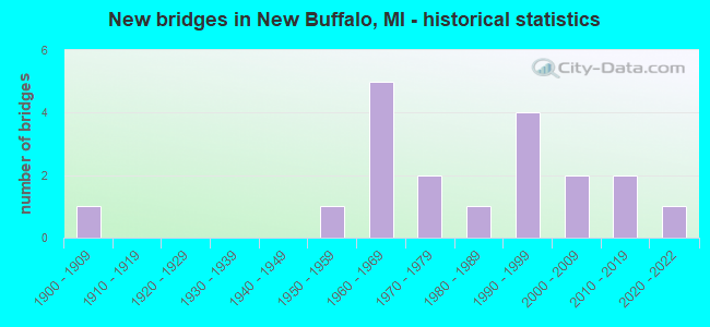
- New bridges - historical statistics
- 11900-1909
- 11950-1959
- 51960-1969
- 21970-1979
- 11980-1989
- 41990-1999
- 22000-2009
- 22010-2019
- 12020-2022


- Bridge Condition - Deck
- 9.1%Very good
- 27.3%Good
- 54.5%Satisfactory
- 9.1%Fair

- Bridge Condition - Superstructure
- 18.2%Very good
- 9.1%Good
- 27.3%Satisfactory
- 45.5%Fair

- Bridge Condition - Substructure
- 27.3%Very good
- 45.5%Good
- 18.2%Satisfactory
- 9.1%Fair

- Bridge Condition - Channel
- 11.1%Very good
- 33.3%Good
- 11.1%Satisfactory
- 44.4%Fair
Find on map >> Show street view
Structure Number: 78, Location: 0.8 MI SE OF NEW BUFFALO (Lat: 41.774450, Lng: -86.730717), Route carried "on" structure: State highway 239, Year Built: 1963, Status: Open, Structure Length: 7.39m (24.25ft), Average Daily Traffic: 6,400 (year 2016), Truck Traffic: 28%, Average Future Daily Traffic: 7,360 (year 2036), Design Load: HS 20+Mod, Features Intersected: I-94
Minimum Vertical Clearance: 30.48m (100.00ft), Kilometerpoint: 1.799, Lanes on structure: 4, Lanes under structure: 8, Base Highway Network: Yes (Inventory Route: 136, Subroute: 7), Owner: State Highway Agency, Approaching Roadway Width: 17.7m (58.1ft), Skew: 1 degrees, Material/Design: Steel, Design/Construction: Stringer/Multi-beam, Number Of Spans In Main Unit: 4, Length of Maximum Span: 25.9m (85.0ft), Curb-To-Curb Width: 17.7m (58.1ft), Out-to-Out Width: 18.7m (61.4ft)
Condition: Deck: Satisfactory, Superstructure: Fair, Substructure: Satisfactory, Operating Rating: 58.6 metric tons, Method Used To Determine Operating Rating: Load Factor (LF) rating reported by rating factor (RF) method using MS18 loading, Inventory Rating: 35.0 metric tons, Method Used To Determine Inventory Rating: Load Factor (LF) rating reported by rating factor (RF) method using MS18 loading, Structural Evaluation: Somewhat better than minimum adequacy, Deck Geometry: Somewhat better than minimum adequacy, Underclear: Somewhat better than minimum adequacy, Approach Roadway Alignment: Equal to present desirable criteria, Designated Inspection Frequency: Every 24 months, Inspection Date: October 2020, Deck Structure Type: Concrete Cast-file-Place, Wearing Surface/Protective System: Wearing Surface: Latex Concrete, Deck Protection: Epoxy Coated Reinforcing
Find on map >> Show street view
Structure Number: 782, Location: 2.5 MI NE OF NEW BUFFALO (Lat: 41.819661, Lng: -86.688386), Route carried "on" structure: Interstate 94, Year Built: 2008, Status: Open, Structure Length: 5.94m (19.49ft), Average Daily Traffic: 18,879 (year 2007), Truck Traffic: 30%, Average Future Daily Traffic: 47,000 (year 2028), Design Load: HS 25 or greater, Features Intersected: GALIEN RIVER
Minimum Vertical Clearance: 30.48m (100.00ft), Kilometerpoint: 8.488, Lanes on structure: 3, Base Highway Network: Yes (Inventory Route: 136, Subroute: 4), Owner: State Highway Agency, Approaching Roadway Width: 18.3m (60.0ft), Material/Design: Prestressed concrete, Design/Construction: Box Beam or Girders - Single/Spread, Number Of Spans In Main Unit: 3, Length of Maximum Span: 20.7m (67.9ft), Curb-To-Curb Width: 18.3m (60.0ft), Out-to-Out Width: 19.3m (63.3ft)
Condition: Deck: Good, Superstructure: Very good, Substructure: Good, Channel: Fair, Operating Rating: 83.3 metric tons, Method Used To Determine Operating Rating: Load Factor (LF), Inventory Rating: 42.3 metric tons, Method Used To Determine Inventory Rating: Load Factor (LF), Structural Evaluation: Better than present minimum criteria, Deck Geometry: Better than present minimum criteria, Waterway Adequacy: Equal to present desirable criteria, Approach Roadway Alignment: Equal to present desirable criteria, Designated Inspection Frequency: Every 24 months, Inspection Date: August 2020, Deck Structure Type: Concrete Cast-file-Place, Wearing Surface/Protective System: Wearing Surface: Monolithic Concrete, Deck Protection: Other
Find on map >> Show street view
Structure Number: 799, Location: 0.7 MI NE OF NEW BUFFALO (Lat: 41.799125, Lng: -86.708225), Route carried "on" structure: Interstate 94, Year Built: 1998, Status: Open, Structure Length: 7.31m (23.98ft), Average Daily Traffic: 19,340 (year 2007), Truck Traffic: 31%, Average Future Daily Traffic: 25,386 (year 2018), Design Load: HS 25 or greater, Features Intersected: US-12
Minimum Vertical Clearance: 30.48m (100.00ft), Kilometerpoint: 5.657, Lanes on structure: 4, Lanes under structure: 6, Base Highway Network: Yes (Inventory Route: 136, Subroute: 2), Owner: State Highway Agency, Approaching Roadway Width: 16.0m (52.5ft), Skew: 3 degrees, Material/Design: Prestressed concrete, Design/Construction: Box Beam or Girders - Multiple, Number Of Spans In Main Unit: 4, Length of Maximum Span: 24.0m (78.7ft), Curb-To-Curb Width: 21.9m (71.9ft), Out-to-Out Width: 22.9m (75.1ft)
Condition: Deck: Satisfactory, Superstructure: Fair, Substructure: Good, Operating Rating: 84.3 metric tons, Method Used To Determine Operating Rating: Load Factor (LF), Inventory Rating: 47.9 metric tons, Method Used To Determine Inventory Rating: Load Factor (LF), Structural Evaluation: Somewhat better than minimum adequacy, Deck Geometry: Better than present minimum criteria, Underclear: High priority of corrective action, Approach Roadway Alignment: Equal to present desirable criteria, Designated Inspection Frequency: Every 24 months, Inspection Date: October 2020, Deck Structure Type: Concrete Cast-file-Place, Wearing Surface/Protective System: Wearing Surface: Monolithic Concrete, Deck Protection: Epoxy Coated Reinforcing
Find on map >> Show street view
Structure Number: 8, Location: 1.1 MI S OF UNION PIER (Lat: 41.813650, Lng: -86.694906), Route carried "on" structure: County highway , Year Built: 1962, Status: Open, Structure Length: 8.88m (29.13ft), Average Daily Traffic: 149 (year 2012), Truck Traffic: 2%, Average Future Daily Traffic: 171 (year 2032), Design Load: H 15, Features Intersected: I-94, Facility Carried by Structure: KRUGER ROAD
Minimum Vertical Clearance: 30.48m (100.00ft), Kilometerpoint: 2.118, Lanes on structure: 2, Lanes under structure: 6, Owner: State Highway Agency, Approaching Roadway Width: 8.2m (26.9ft), Skew: 3 degrees, Material/Design: Steel, Design/Construction: Stringer/Multi-beam, Number Of Spans In Main Unit: 5, Length of Maximum Span: 21.5m (70.5ft), Curb-To-Curb Width: 8.2m (26.9ft), Out-to-Out Width: 9.3m (30.5ft)
Condition: Deck: Fair, Superstructure: Fair, Substructure: Good, Operating Rating: 68.7 metric tons, Method Used To Determine Operating Rating: Load Factor (LF) rating reported by rating factor (RF) method using MS18 loading, Inventory Rating: 41.1 metric tons, Method Used To Determine Inventory Rating: Load Factor (LF) rating reported by rating factor (RF) method using MS18 loading, Structural Evaluation: Somewhat better than minimum adequacy, Deck Geometry: Somewhat better than minimum adequacy, Underclear: Meets minimum limits, Approach Roadway Alignment: Equal to present desirable criteria, Designated Inspection Frequency: Every 24 months, Inspection Date: October 2020, Deck Structure Type: Concrete Cast-file-Place, Wearing Surface/Protective System: Wearing Surface: Latex Concrete, Deck Protection: Epoxy Coated Reinforcing
Find on map >> Show street view
Structure Number: 856, Location: 3.0 MI E OF NEW BUFFALO (Lat: 41.799047, Lng: -86.689464), Route carried "on" structure: US 12, Year Built: 1953, Status: Open, Structure Length: 3.93m (12.89ft), Average Daily Traffic: 6,125 (year 2018), Truck Traffic: 11%, Average Future Daily Traffic: 6,750 (year 2038), Design Load: HS 20, Features Intersected: GALIEN RIVER
Minimum Vertical Clearance: 30.48m (100.00ft), Kilometerpoint: 2.638, Lanes on structure: 2, Base Highway Network: Yes (Inventory Route: 135, Subroute: 7), Owner: State Highway Agency, Approaching Roadway Width: 13.4m (44.0ft), Material/Design: Steel, Design/Construction: Stringer/Multi-beam, Number Of Spans In Main Unit: 3, Length of Maximum Span: 13.1m (43.0ft), Curb-To-Curb Width: 13.3m (43.6ft), Out-to-Out Width: 14.3m (46.9ft)
Condition: Deck: Satisfactory, Superstructure: Fair, Substructure: Satisfactory, Channel: Fair, Operating Rating: 75.8 metric tons, Method Used To Determine Operating Rating: Load Factor (LF) rating reported by rating factor (RF) method using MS18 loading, Inventory Rating: 45.4 metric tons, Method Used To Determine Inventory Rating: Load Factor (LF) rating reported by rating factor (RF) method using MS18 loading, Structural Evaluation: Somewhat better than minimum adequacy, Deck Geometry: Somewhat better than minimum adequacy, Waterway Adequacy: Equal to present desirable criteria, Approach Roadway Alignment: Equal to present desirable criteria, Designated Inspection Frequency: Every 24 months, Inspection Date: July 2020, Deck Structure Type: Concrete Cast-file-Place, Wearing Surface/Protective System: Wearing Surface: Latex Concrete
Find on map >> Show street view
Structure Number: 979, Location: 0.25 MI N E NEW BUFFALO (Lat: 41.802903, Lng: -86.719233), Route carried "on" structure: County highway 1105, Year Built: 2003, Status: Open, Structure Length: 5.23m (17.16ft), Average Daily Traffic: 4,896 (year 2007), Truck Traffic: 8%, Average Future Daily Traffic: 8,000 (year 2027), Design Load: HS 25 or greater, Features Intersected: NAT RAIL PASS CO AMTRAK, Facility Carried by Structure: RED ARROW HIGHWAY
Minimum Vertical Clearance: 30.48m (100.00ft), Kilometerpoint: 8.483, Lanes on structure: 4, Owner: County Highway Agency, Approaching Roadway Width: 17.1m (56.1ft), Skew: 3 degrees, Material/Design: Prestressed concrete continuous, Design/Construction: Box Beam or Girders - Single/Spread, Number Of Spans In Main Unit: 3, Length of Maximum Span: 18.8m (61.7ft), Curb-To-Curb Width: 19.4m (63.6ft), Out-to-Out Width: 20.1m (65.9ft)
Condition: Deck: Satisfactory, Superstructure: Satisfactory, Substructure: Good, Operating Rating: 79.4 metric tons, Method Used To Determine Operating Rating: Load Factor (LF) rating reported by rating factor (RF) method using MS18 loading, Inventory Rating: 47.6 metric tons, Method Used To Determine Inventory Rating: Load Factor (LF) rating reported by rating factor (RF) method using MS18 loading, Structural Evaluation: Equal to present minimum criteria, Deck Geometry: Better than present minimum criteria, Underclear: Somewhat better than minimum adequacy, Approach Roadway Alignment: Better than present minimum criteria, Designated Inspection Frequency: Every 24 months, Inspection Date: April 2020, Deck Structure Type: Concrete Cast-file-Place, Wearing Surface/Protective System: Wearing Surface: Monolithic Concrete, Deck Protection: Epoxy Coated Reinforcing
Find on map >> Show street view
Structure Number: 98, Location: 0.75 N E OF NEW BUFFALO (Lat: 41.808542, Lng: -86.715258), Route carried "on" structure: County highway 1105, Year Built: 1992, Status: Open, Structure Length: 3.17m (10.40ft), Average Daily Traffic: 4,898 (year 2007), Truck Traffic: 4%, Average Future Daily Traffic: 7,000 (year 2027), Design Load: HS 20+Mod, Features Intersected: GALIEN RIVER, Facility Carried by Structure: RED ARROW HIGHWAY
Minimum Vertical Clearance: 30.48m (100.00ft), Kilometerpoint: 9.193, Lanes on structure: 4, Owner: County Highway Agency, Approaching Roadway Width: 19.5m (64.0ft), Material/Design: Prestressed concrete, Design/Construction: Box Beam or Girders - Multiple, Number Of Spans In Main Unit: 1, Length of Maximum Span: 31.4m (103.0ft), Curb-To-Curb Width: 19.5m (64.0ft), Out-to-Out Width: 20.2m (66.3ft)
Condition: Deck: Satisfactory, Superstructure: Satisfactory, Substructure: Very good, Channel: Good, Operating Rating: 87.2 metric tons, Method Used To Determine Operating Rating: Load Factor (LF) rating reported by rating factor (RF) method using MS18 loading, Inventory Rating: 52.2 metric tons, Method Used To Determine Inventory Rating: Load Factor (LF) rating reported by rating factor (RF) method using MS18 loading, Structural Evaluation: Equal to present minimum criteria, Deck Geometry: Better than present minimum criteria, Waterway Adequacy: Equal to present desirable criteria, Approach Roadway Alignment: Equal to present desirable criteria, Designated Inspection Frequency: Every 24 months, Inspection Date: June 2020, Deck Structure Type: Concrete Cast-file-Place, Wearing Surface/Protective System: Wearing Surface: Monolithic Concrete, Deck Protection: Epoxy Coated Reinforcing
Find on map >> Show street view
Structure Number: 1019, Location: 4 MI NW OF NEW BUFFALO (Lat: 41.817556, Lng: -86.680392), Route carried "on" structure: County highway , Year Built: 1908, Year Reconstructed: 1997, Status: Posted for load, Structure Length: 1.97m (6.46ft), Average Daily Traffic: 35 (year 2012), Average Future Daily Traffic: 100 (year 2032), Design Load: HS 20, Features Intersected: GALIEN RIVER, Facility Carried by Structure: GLASSMAN ROAD
Minimum Vertical Clearance: 30+ m (98+ ft), Kilometerpoint: 0.464, Lanes on structure: 2, Owner: County Highway Agency, Approaching Roadway Width: 8.8m (28.9ft), Material/Design: Steel, Design/Construction: Stringer/Multi-beam, Number Of Spans In Main Unit: 1, Length of Maximum Span: 18.2m (59.7ft), Curb-To-Curb Width: 7.3m (24.0ft), Out-to-Out Width: 7.7m (25.3ft)
Condition: Deck: Good, Superstructure: Fair, Substructure: Fair, Channel: Satisfactory, Operating Rating: 53.5 metric tons, Method Used To Determine Operating Rating: Load Factor (LF) rating reported by rating factor (RF) method using MS18 loading, Inventory Rating: 32.1 metric tons, Method Used To Determine Inventory Rating: Load Factor (LF) rating reported by rating factor (RF) method using MS18 loading, Structural Evaluation: Somewhat better than minimum adequacy, Deck Geometry: Equal to present minimum criteria, Waterway Adequacy: Superior to present desirable criteria, Approach Roadway Alignment: Meets minimum limits, Bridge Posting: Required (Relationship of Operating Rating to Maximum Legal Load: 10.0 - 19.9% below), Designated Inspection Frequency: Every 24 months, Inspection Date: July 2020, Deck Structure Type: Wood or Timber, Wearing Surface/Protective System: Wearing Surface: Bituminous
Find on map >> Show street view
Structure Number: 1056, Location: 3 BLKS NORTH OF US-12 (Lat: 41.797767, Lng: -86.746611), Route carried "on" structure: City street , Year Built: 1975, Status: Open, Structure Length: 6.03m (19.78ft), Average Daily Traffic: 5,615 (year 2009), Truck Traffic: 1%, Average Future Daily Traffic: 8,425 (year 2029), Design Load: HS 20+Mod, Features Intersected: GALIEN RIVER, Facility Carried by Structure: WHITTAKER STREET
Minimum Vertical Clearance: 30.48m (100.00ft), Kilometerpoint: 4.757, Lanes on structure: 2, Owner: City or Municipal Highway Agency, Approaching Roadway Width: 8.5m (27.9ft), Material/Design: Prestressed concrete, Design/Construction: Box Beam or Girders - Multiple, Number Of Spans In Main Unit: 3, Length of Maximum Span: 20.1m (65.9ft), Curb or Sidewalk Widths: Left: 1.5m (4.9ft), Right: 0.0m, Curb-To-Curb Width: 8.5m (27.9ft), Out-to-Out Width: 11.2m (36.7ft)
Condition: Deck: Satisfactory, Superstructure: Satisfactory, Substructure: Good, Channel: Good, Operating Rating: 64.5 metric tons, Method Used To Determine Operating Rating: Field evaluation and documented engineering judgment, Inventory Rating: 38.6 metric tons, Method Used To Determine Inventory Rating: Field evaluation and documented engineering judgment, Structural Evaluation: Equal to present minimum criteria, Deck Geometry: Meets minimum limits, Waterway Adequacy: Equal to present desirable criteria, Approach Roadway Alignment: Equal to present minimum criteria, Designated Inspection Frequency: Every 24 months, Inspection Date: August 2020, Wearing Surface/Protective System: Wearing Surface: Bituminous, Membrane: Preformed Fabric
Find on map >> Show street view
Structure Number: 2774, Location: BET CALKINS & BEECHER RD (Lat: 43.025386, Lng: -83.910828), Route carried "on" structure: County highway , Year Built: 2014, Status: Open, Structure Length: 1.95m (6.40ft), Average Daily Traffic: 243 (year 2009), Truck Traffic: 3%, Average Future Daily Traffic: 439 (year 2029), Design Load: Greater than HL93, Features Intersected: MISTEGUAY CREEK, Facility Carried by Structure: DUFFIELD ROAD
Minimum Vertical Clearance: 30.48m (100.00ft), Kilometerpoint: 7.608, Lanes on structure: 2, Owner: County Highway Agency, Approaching Roadway Width: 9.8m (32.2ft), Skew: 1 degrees, Material/Design: Prestressed concrete, Design/Construction: Box Beam or Girders - Multiple, Number Of Spans In Main Unit: 1, Length of Maximum Span: 19.1m (62.7ft), Curb-To-Curb Width: 9.5m (31.2ft), Out-to-Out Width: 10.6m (34.8ft)
Condition: Deck: Very good, Superstructure: Very good, Substructure: Very good, Channel: Very good, Operating Rating: 73.5 metric tons, Method Used To Determine Operating Rating: Load and Resistance Factor Rating (LRFR) rating reported by rating factor(RF) method using HL-93 loadings, Inventory Rating: 56.7 metric tons, Method Used To Determine Inventory Rating: Load and Resistance Factor Rating (LRFR) rating reported by rating factor(RF) method using HL-93 loadings, Structural Evaluation: Equal to present desirable criteria, Deck Geometry: Equal to present minimum criteria, Waterway Adequacy: Equal to present desirable criteria, Approach Roadway Alignment: Equal to present desirable criteria, Designated Inspection Frequency: Every 24 months, Inspection Date: November 2020, Deck Structure Type: Concrete Cast-file-Place, Wearing Surface/Protective System: Wearing Surface: Monolithic Concrete, Deck Protection: Epoxy Coated Reinforcing
Find on map >> Show street view
Structure Number: 5199, Location: 475 FT WEST OF MONROE AVE (Lat: 42.970364, Lng: -85.674017), Route carried "on" structure: Business County highway 2001, Year Built: 1988, Status: Open, Structure Length: 13.90m (45.60ft), Average Daily Traffic: 15,226 (year 2018), Truck Traffic: 10%, Average Future Daily Traffic: 17,680 (year 2038), Design Load: HS 20+Mod, Features Intersected: GRAND RIVER, Facility Carried by Structure: BRIDGE STREET
Minimum Vertical Clearance: 30.48m (100.00ft), Kilometerpoint: 3.578, Lanes on structure: 4, Owner: City or Municipal Highway Agency, Approaching Roadway Width: 14.3m (46.9ft), Material/Design: Prestressed concrete, Design/Construction: Stringer/Multi-beam, Number Of Spans In Main Unit: 5, Length of Maximum Span: 29.2m (95.8ft), Curb or Sidewalk Widths: Left: 2.5m (8.2ft), Right: 2.5m (8.2ft), Curb-To-Curb Width: 14.3m (46.9ft), Out-to-Out Width: 20.1m (65.9ft)
Condition: Deck: Good, Superstructure: Good, Substructure: Very good, Channel: Good, Inventory Rating: 61.2 metric tons, Method Used To Determine Inventory Rating: Load Factor (LF), Structural Evaluation: Better than present minimum criteria, Deck Geometry: High priority of replacement, Waterway Adequacy: Equal to present desirable criteria, Approach Roadway Alignment: Equal to present desirable criteria, Designated Inspection Frequency: Every 24 months, Inspection Date: August 2021, Deck Structure Type: Concrete Cast-file-Place, Wearing Surface/Protective System: Wearing Surface: Epoxy Overlay, Deck Protection: Epoxy Coated Reinforcing
Find on map >> Show street view
Structure Number: 13629, Location: EAST OF I-94/US-12 INTCHG (Lat: 41.799006, Lng: -86.697669), Route carried "on" structure: US 12, Year Built: 2013, Status: Open, Structure Length: 0.68m (2.23ft), Average Daily Traffic: 7,200 (year 2011), Truck Traffic: 13%, Average Future Daily Traffic: 8,360 (year 2031), Design Load: Greater than HL93, Features Intersected: NOKMES CREEK
Minimum Vertical Clearance: 30.48m (100.00ft), Kilometerpoint: 1.941, Lanes on structure: 4, Base Highway Network: Yes (Inventory Route: 135, Subroute: 7), Owner: State Highway Agency, Approaching Roadway Width: 24.4m (80.1ft), Skew: 20 degrees, Material/Design: Concrete, Design/Construction: Culvert, Number Of Spans In Main Unit: 1, Length of Maximum Span: 6.1m (20.0ft), Curb-To-Curb Width: 24.4m (80.1ft), Out-to-Out Width: 62.5m (205.1ft)
Condition: Channel: Fair, Culverts: Good, Operating Rating: 97.2 metric tons, Method Used To Determine Operating Rating: Load and Resistance Factor Rating (LRFR) rating reported by rating factor(RF) method using HL-93 loadings, Inventory Rating: 97.2 metric tons, Method Used To Determine Inventory Rating: Load and Resistance Factor Rating (LRFR) rating reported by rating factor(RF) method using HL-93 loadings, Structural Evaluation: Better than present minimum criteria, Deck Geometry: Superior to present desirable criteria, Waterway Adequacy: Better than present minimum criteria, Approach Roadway Alignment: Equal to present desirable criteria, Designated Inspection Frequency: Every 24 months, Inspection Date: March 2020, Wearing Surface/Protective System: Wearing Surface: Bituminous
Find on map >> Show street view
Structure Number: 14307, Location: 0.2 MI S OF MAUDLIN RD (Lat: 41.786100, Lng: -86.718053), Route carried "on" structure: Interstate 94, Year Built: 2020, Status: Open, Structure Length: 0.67m (2.20ft), Average Daily Traffic: 45,139 (year 2018), Truck Traffic: 25%, Average Future Daily Traffic: 52,415 (year 2038), Design Load: Greater than HL93, Features Intersected: NOKMES CREEK
Minimum Vertical Clearance: 30.48m (100.00ft), Kilometerpoint: 3.990, Lanes on structure: 11, Base Highway Network: Yes (Inventory Route: 136, Subroute: 4), Owner: State Highway Agency, Approaching Roadway Width: 34.1m (111.9ft), Material/Design: Concrete, Design/Construction: Culvert, Number Of Spans In Main Unit: 1, Length of Maximum Span: 6.7m (22.0ft), Out-to-Out Width: 158.5m (520.0ft)
Condition: Channel: Fair, Culverts: Good, Operating Rating: 97.2 metric tons, Method Used To Determine Operating Rating: Load and Resistance Factor Rating (LRFR) rating reported by rating factor(RF) method using HL-93 loadings, Inventory Rating: 97.2 metric tons, Method Used To Determine Inventory Rating: Load and Resistance Factor Rating (LRFR) rating reported by rating factor(RF) method using HL-93 loadings, Structural Evaluation: Better than present minimum criteria, Waterway Adequacy: Superior to present desirable criteria, Approach Roadway Alignment: Equal to present desirable criteria, Designated Inspection Frequency: Every 24 months, Inspection Date: March 2022, Wearing Surface/Protective System: Wearing Surface: Bituminous
Find on map >> Show street view
Structure Number: 779, Location: 2.8 MI SW OF US-12 (Lat: 41.770036, Lng: -86.736628), Route carried "under" structure: Interstate 94, Year Built: 1971, Structure Length: 0. m, Average Daily Traffic: 37,900 (year 2010), Truck Traffic: 37%, Features Intersected: I-94, Facility Carried by Structure: WILSON ROAD
Minimum Vertical Clearance: 5.11m (16.77ft), Kilometerpoint: 1.634, Lanes on structure: 2, Lanes under structure: 7, Material/Design: Steel, Design/Construction: Stringer/Multi-beam, Length of Maximum Span: 41.1m (134.8ft)
Find on map >> Show street view
Structure Number: 78, Location: 0.8 MI SE OF NEW BUFFALO (Lat: 41.774450, Lng: -86.730717), Route carried "under" structure: Interstate 94, Year Built: 1963, Structure Length: 0. m, Average Daily Traffic: 43,500 (year 2016), Truck Traffic: 35%, Features Intersected: I-94, Facility Carried by Structure: M-239 LAPORTE ROAD
Minimum Vertical Clearance: 5.05m (16.57ft), Kilometerpoint: 2.327, Lanes on structure: 4, Lanes under structure: 8, Material/Design: Steel, Design/Construction: Stringer/Multi-beam, Length of Maximum Span: 25.9m (85.0ft)
Find on map >> Show street view
Structure Number: 781, Location: 0.5 MI E OF NEW BUFFALO (Lat: 41.788703, Lng: -86.715822), Route carried "under" structure: Interstate 94, Year Built: 1964, Structure Length: 0. m, Average Daily Traffic: 43,500 (year 2016), Truck Traffic: 35%, Features Intersected: I-94, Facility Carried by Structure: MAUDLIN ROAD
Minimum Vertical Clearance: 5.11m (16.77ft), Kilometerpoint: 4.350, Lanes on structure: 2, Lanes under structure: 8, Material/Design: Steel, Design/Construction: Stringer/Multi-beam, Length of Maximum Span: 24.9m (81.7ft)
Find on map >> Show street view
Structure Number: 798, Location: 0.7 MI NE OF NEW BUFFALO (Lat: 41.799117, Lng: -86.706122), Route carried "under" structure: US 12, Year Built: 1998, Structure Length: 0. m, Average Daily Traffic: 6,988 (year 2007), Truck Traffic: 12%, Features Intersected: US-12, Facility Carried by Structure: I-94 EB
Minimum Vertical Clearance: 4.98m (16.34ft), Kilometerpoint: 1.239, Lanes on structure: 4, Lanes under structure: 6, Material/Design: Prestressed concrete, Design/Construction: Box Beam or Girders - Multiple, Length of Maximum Span: 24.0m (78.7ft)
Find on map >> Show street view
Structure Number: 799, Location: 0.7 MI NE OF NEW BUFFALO (Lat: 41.799125, Lng: -86.708225), Route carried "under" structure: US 12, Year Built: 1998, Structure Length: 0. m, Average Daily Traffic: 6,258 (year 2007), Truck Traffic: 14%, Features Intersected: US-12, Facility Carried by Structure: I-94 WB
Minimum Vertical Clearance: 5.16m (16.93ft), Kilometerpoint: 1.062, Lanes on structure: 4, Lanes under structure: 6, Material/Design: Prestressed concrete, Design/Construction: Box Beam or Girders - Multiple, Length of Maximum Span: 24.0m (78.7ft)
Find on map >> Show street view
Structure Number: 8, Location: 1.1 MI S OF UNION PIER (Lat: 41.813650, Lng: -86.694906), Route carried "under" structure: Interstate 94, Year Built: 1962, Structure Length: 0. m, Average Daily Traffic: 42,600 (year 2016), Truck Traffic: 27%, Features Intersected: I-94, Facility Carried by Structure: KRUGER ROAD
Minimum Vertical Clearance: 5.26m (17.26ft), Kilometerpoint: 7.630, Lanes on structure: 2, Lanes under structure: 6, Material/Design: Steel, Design/Construction: Stringer/Multi-beam, Length of Maximum Span: 21.5m (70.5ft)