Bridge Statistics for New Castle, New York (NY)
Condition, Traffic, Stress, Structural Evaluation, Project Costs
- National Bridge Inventory (NBI) Statistics
- 18Number of bridges
- 135ft / 41.0mTotal length
- $43,889,000Total costs
- 190,245Total average daily traffic
- 3,246Total average daily truck traffic
- National Bridge Inventory (NBI) Registered Bridges for New Castle
- No street view available for this location
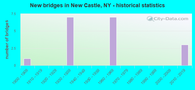
- New bridges - historical statistics
- 11900-1909
- 71930-1939
- 71960-1969
- 32010-2019
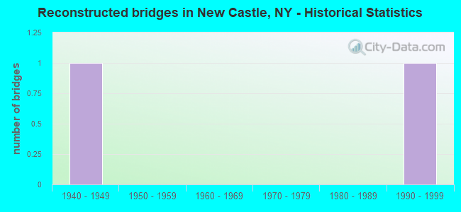
- Reconstructed bridges - Historical Statistics
- 11940-1949
- 01950-1959
- 01960-1969
- 01970-1979
- 01980-1989
- 11990-1999
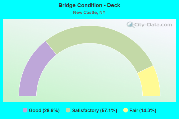
- Bridge Condition - Deck
- 28.6%Good
- 57.1%Satisfactory
- 14.3%Fair
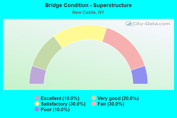
- Bridge Condition - Superstructure
- 10.0%Excellent
- 20.0%Very good
- 30.0%Satisfactory
- 30.0%Fair
- 10.0%Poor
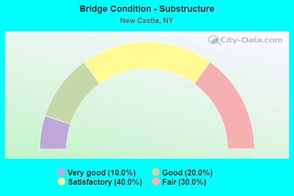
- Bridge Condition - Substructure
- 10.0%Very good
- 20.0%Good
- 40.0%Satisfactory
- 30.0%Fair
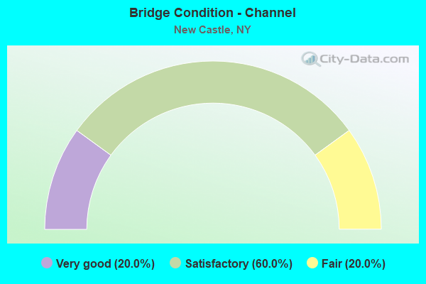
- Bridge Condition - Channel
- 20.0%Very good
- 60.0%Satisfactory
- 20.0%Fair
Find on map >> Show street view
Structure Number: 1036121, Location: JCT TSP&RTE 100 (Lat: 41.184964, Lng: -73.807378), Route carried "on" structure: Other road 987G, Year Built: 1968, Status: Open, Structure Length: 7.74m (25.39ft), Truck Traffic: 2%, Design Load: HS 20, Features Intersected: RTE 100
Minimum Vertical Clearance: 30+ m (98+ ft), Kilometerpoint: 14.401, Lanes on structure: 3, Lanes under structure: 4, Base Highway Network: Yes, Owner: State Highway Agency, Approaching Roadway Width: 15.2m (49.9ft), Skew: 5 degrees, Material/Design: Steel, Design/Construction: Stringer/Multi-beam, Number Of Spans In Main Unit: 3, Length of Maximum Span: 39.3m (128.9ft), Curb-To-Curb Width: 12.8m (42.0ft), Out-to-Out Width: 13.7m (44.9ft)
Condition: Deck: Satisfactory, Superstructure: Fair, Substructure: Fair, Operating Rating: 68.9 metric tons, Method Used To Determine Operating Rating: Load Factor (LF), Inventory Rating: 41.7 metric tons, Method Used To Determine Inventory Rating: Load Factor (LF), Structural Evaluation: Somewhat better than minimum adequacy, Deck Geometry: Meets minimum limits, Underclear: Meets minimum limits, Approach Roadway Alignment: Equal to present desirable criteria, Length Of Structure Improvement: 7.74m (25.39ft), Designated Inspection Frequency: Every 24 months, Inspection Date: September 2020, Bridge Improvement Cost: $4,426,000, Roadway Improvement Cost: $2,592,000, Total Project Cost: $7,018,000 ( Estimate for 2021), Deck Structure Type: Concrete Cast-file-Place, Wearing Surface/Protective System: Wearing Surface: Integral Concrete
Find on map >> Show street view
Structure Number: 1036122, Location: JCT TSP & RTE 100 (Lat: 41.185167, Lng: -73.807103), Route carried "on" structure: Other road 987G, Year Built: 1968, Status: Open, Structure Length: 7.16m (23.49ft), Truck Traffic: 2%, Design Load: HS 20, Features Intersected: RTE 100
Minimum Vertical Clearance: 30+ m (98+ ft), Kilometerpoint: 14.401, Lanes on structure: 3, Lanes under structure: 4, Base Highway Network: Yes, Owner: State Highway Agency, Approaching Roadway Width: 12.8m (42.0ft), Skew: 5 degrees, Material/Design: Steel, Design/Construction: Stringer/Multi-beam, Number Of Spans In Main Unit: 3, Length of Maximum Span: 37.5m (123.0ft), Curb-To-Curb Width: 12.8m (42.0ft), Out-to-Out Width: 13.7m (44.9ft)
Condition: Deck: Satisfactory, Superstructure: Fair, Substructure: Satisfactory, Operating Rating: 30.1 metric tons, Method Used To Determine Operating Rating: Load and Resistance Factor Rating (LRFR) rating reported by rating factor(RF) method using HL-93 loadings, Inventory Rating: 23.3 metric tons, Method Used To Determine Inventory Rating: Load and Resistance Factor Rating (LRFR) rating reported by rating factor(RF) method using HL-93 loadings, Structural Evaluation: Somewhat better than minimum adequacy, Deck Geometry: Meets minimum limits, Underclear: Meets minimum limits, Approach Roadway Alignment: Equal to present desirable criteria, Length Of Structure Improvement: 7.16m (23.49ft), Designated Inspection Frequency: Every 24 months, Inspection Date: September 2020, Bridge Improvement Cost: $4,118,000, Roadway Improvement Cost: $2,412,000, Total Project Cost: $6,530,000 ( Estimate for 2021), Deck Structure Type: Concrete Cast-file-Place, Wearing Surface/Protective System: Wearing Surface: Integral Concrete
Find on map >> Show street view
Structure Number: 103735, Location: 3.8 MI N JCT SH120 & US 1 (Lat: 41.158825, Lng: -73.774244), Route carried "on" structure: State highway 120, Year Built: 2010, Status: Open, Structure Length: 4.33m (14.21ft), Average Daily Traffic: 8,234 (year 2019), Truck Traffic: 3%, Average Future Daily Traffic: 10,002 (year 2040), Features Intersected: RAILROAD STREET, MNRR HA
Minimum Vertical Clearance: 30+ m (98+ ft), Kilometerpoint: 23.588, Lanes on structure: 3, Lanes under structure: 2, Base Highway Network: Yes, Owner: Railroad, Maintenance Responsibility: State Highway Agency, Approaching Roadway Width: 13.7m (44.9ft), Material/Design: Steel continuous, Design/Construction: Stringer/Multi-beam, Number Of Spans In Main Unit: 2, Length of Maximum Span: 24.1m (79.1ft), Curb or Sidewalk Widths: Left: 1.7m (5.6ft), Right: 1.7m (5.6ft), Curb-To-Curb Width: 13.7m (44.9ft), Out-to-Out Width: 18.2m (59.7ft)
Condition: Deck: Good, Superstructure: Very good, Substructure: Good, Operating Rating: 74.4 metric tons, Method Used To Determine Operating Rating: Load Factor (LF), Inventory Rating: 44.5 metric tons, Method Used To Determine Inventory Rating: Load Factor (LF), Structural Evaluation: Better than present minimum criteria, Deck Geometry: Somewhat better than minimum adequacy, Underclear: Somewhat better than minimum adequacy, Approach Roadway Alignment: Equal to present minimum criteria, Length Of Structure Improvement: 4.32m (14.17ft), Designated Inspection Frequency: Every 24 months, Inspection Date: September 2021, Bridge Improvement Cost: $4,417,000, Roadway Improvement Cost: $2,587,000, Total Project Cost: $7,003,000 ( Estimate for 2021), Deck Structure Type: Concrete Cast-file-Place, Wearing Surface/Protective System: Wearing Surface: Integral Concrete, Deck Protection: Epoxy Coated Reinforcing
Find on map >> Show street view
Structure Number: 103736, Location: JCT. RTE. 120 & SMRP (Lat: 41.159067, Lng: -73.774639), Route carried "on" structure: State highway 120, Year Built: 1930, Status: Open, Structure Length: 2.01m (6.59ft), Average Daily Traffic: 5,130 (year 2015), Truck Traffic: 4%, Average Future Daily Traffic: 6,231 (year 2040), Design Load: H 20, Features Intersected: 987D 987D87012152 SB, RT
Minimum Vertical Clearance: 30+ m (98+ ft), Kilometerpoint: 23.668, Lanes on structure: 4, Lanes under structure: 4, Base Highway Network: Yes, Owner: State Highway Agency, Approaching Roadway Width: 9.1m (29.9ft), Material/Design: Concrete, Design/Construction: Frame, Number Of Spans In Main Unit: 1, Length of Maximum Span: 17.3m (56.8ft), Curb or Sidewalk Widths: Left: 1.5m (4.9ft), Right: 1.5m (4.9ft), Curb-To-Curb Width: 9.1m (29.9ft), Out-to-Out Width: 13.1m (43.0ft)
Condition: Superstructure: Satisfactory, Substructure: Satisfactory, Operating Rating: 55.7 metric tons, Method Used To Determine Operating Rating: Field evaluation and documented engineering judgment, Inventory Rating: 22.3 metric tons, Method Used To Determine Inventory Rating: Field evaluation and documented engineering judgment, Structural Evaluation: Somewhat better than minimum adequacy, Deck Geometry: High priority of replacement, Underclear: High priority of corrective action, Approach Roadway Alignment: Meets minimum limits, Length Of Structure Improvement: 2.01m (6.59ft), Designated Inspection Frequency: Every 24 months, Inspection Date: October 2020, Bridge Improvement Cost: $1,623,000, Roadway Improvement Cost: $951,000, Total Project Cost: $2,574,000 ( Estimate for 2021)
Find on map >> Show street view
Structure Number: 103774, Location: 0.3 MI W JCT RTS 117+5MRP (Lat: 41.208286, Lng: -73.740858), Route carried "on" structure: State highway 133, Year Built: 1931, Status: Open, Structure Length: 1.19m (3.90ft), Average Daily Traffic: 6,792 (year 2016), Truck Traffic: 4%, Average Future Daily Traffic: 8,250 (year 2040), Design Load: H 20, Features Intersected: KISCO RIVER
Minimum Vertical Clearance: 30+ m (98+ ft), Kilometerpoint: 12.582, Lanes on structure: 2, Base Highway Network: Yes, Owner: State Highway Agency, Approaching Roadway Width: 10.7m (35.1ft), Skew: 2 degrees, Material/Design: Concrete, Design/Construction: Tee Beam, Number Of Spans In Main Unit: 1, Length of Maximum Span: 11.6m (38.1ft), Curb or Sidewalk Widths: Left: 1.5m (4.9ft), Right: 1.5m (4.9ft), Curb-To-Curb Width: 10.7m (35.1ft), Out-to-Out Width: 14.1m (46.3ft)
Condition: Deck: Fair, Superstructure: Fair, Substructure: Fair, Channel: Fair, Operating Rating: 51.7 metric tons, Method Used To Determine Operating Rating: Load Factor (LF), Inventory Rating: 30.8 metric tons, Method Used To Determine Inventory Rating: Load Factor (LF), Structural Evaluation: Somewhat better than minimum adequacy, Deck Geometry: Meets minimum limits, Waterway Adequacy: Meets minimum limits, Approach Roadway Alignment: Meets minimum limits, Length Of Structure Improvement: 1.18m (3.87ft), Designated Inspection Frequency: Every 24 months, Inspection Date: September 2020, Bridge Improvement Cost: $730,000, Roadway Improvement Cost: $427,000, Total Project Cost: $1,157,000 ( Estimate for 2021), Deck Structure Type: Concrete Cast-file-Place, Wearing Surface/Protective System: Wearing Surface: Bituminous
Find on map >> Show street view
Structure Number: 105336, Location: .5 MI S JCT SH 100 & TSP (Lat: 41.177794, Lng: -73.811878), Route carried "on" structure: State highway 100, Year Built: 1967, Status: Open, Structure Length: 0.88m (2.89ft), Average Daily Traffic: 5,838 (year 2016), Truck Traffic: 12%, Average Future Daily Traffic: 7,092 (year 2040), Design Load: H 20, Features Intersected: POCANTICO RIVER
Minimum Vertical Clearance: 30+ m (98+ ft), Kilometerpoint: 32.824, Lanes on structure: 4, Base Highway Network: Yes, Owner: State Highway Agency, Approaching Roadway Width: 20.4m (66.9ft), Skew: 26 degrees, Material/Design: Concrete, Design/Construction: Culvert, Number Of Spans In Main Unit: 1, Length of Maximum Span: 8.5m (27.9ft)
Condition: Channel: Satisfactory, Culverts: Satisfactory, Structural Evaluation: Equal to present minimum criteria, Waterway Adequacy: Superior to present desirable criteria, Approach Roadway Alignment: Equal to present desirable criteria, Length Of Structure Improvement: 0.88m (2.89ft), Designated Inspection Frequency: Every 24 months, Inspection Date: May 2020, Bridge Improvement Cost: $509,000, Roadway Improvement Cost: $298,000, Total Project Cost: $806,000 ( Estimate for 2021), Wearing Surface/Protective System: Wearing Surface: Bituminous
Find on map >> Show street view
Structure Number: 226522, Location: 2 MILES NW OF MOUNT KISCO (Lat: 41.234619, Lng: -73.748444), Route carried "on" structure: County highway , Year Built: 1904, Year Reconstructed: 2001, Status: Open, Structure Length: 2.65m (8.69ft), Average Daily Traffic: 2,523 (year 2016), Truck Traffic: 3%, Average Future Daily Traffic: 3,121 (year 2040), Design Load: HS 20, Features Intersected: KISCO RIVER, Facility Carried by Structure: COUNTY ROAD 1323
Minimum Vertical Clearance: 30+ m (98+ ft), Kilometerpoint: 1.416, Lanes on structure: 2, Owner: Local Agency, Approaching Roadway Width: 7.9m (25.9ft), Material/Design: Steel, Design/Construction: Stringer/Multi-beam, Number Of Spans In Main Unit: 1, Length of Maximum Span: 25.6m (84.0ft), Curb-To-Curb Width: 7.9m (25.9ft), Out-to-Out Width: 8.8m (28.9ft)
Condition: Deck: Good, Superstructure: Very good, Substructure: Good, Channel: Very good, Inventory Rating: 75.3 metric tons, Method Used To Determine Inventory Rating: Load Factor (LF), Structural Evaluation: Better than present minimum criteria, Deck Geometry: High priority of corrective action, Waterway Adequacy: Superior to present desirable criteria, Approach Roadway Alignment: Meets minimum limits, Length Of Structure Improvement: 2.65m (8.69ft), Designated Inspection Frequency: Every 24 months, Inspection Date: August 2021, Bridge Improvement Cost: $1,988,000, Roadway Improvement Cost: $1,164,000, Total Project Cost: $3,153,000 ( Estimate for 2021), Deck Structure Type: Concrete Cast-file-Place, Wearing Surface/Protective System: Wearing Surface: Integral Concrete, Deck Protection: Epoxy Coated Reinforcing
Find on map >> Show street view
Structure Number: 5500919, Location: 4.4 MI N JCT RTS SMRP+TSP (Lat: 41.159861, Lng: -73.774089), Route carried "on" structure: Other road 987D, Year Built: 1931, Year Reconstructed: 1947, Status: Open, Structure Length: 1.34m (4.40ft), Average Daily Traffic: 28,444 (year 2013), Truck Traffic: 2%, Average Future Daily Traffic: 40,125 (year 2040), Features Intersected: HUNTS LANE
Minimum Vertical Clearance: 30+ m (98+ ft), Kilometerpoint: 32.952, Lanes on structure: 4, Lanes under structure: 2, Base Highway Network: Yes, Owner: State Highway Agency, Approaching Roadway Width: 15.8m (51.8ft), Skew: 30 degrees, Material/Design: Concrete, Design/Construction: Frame, Number Of Spans In Main Unit: 1, Length of Maximum Span: 11.5m (37.7ft), Curb or Sidewalk Widths: Left: 0.7m (2.3ft), Right: 0.5m (1.6ft), Curb-To-Curb Width: 14.7m (48.2ft), Out-to-Out Width: 17.9m (58.7ft)
Condition: Superstructure: Satisfactory, Substructure: Satisfactory, Operating Rating: 61.1 metric tons, Method Used To Determine Operating Rating: Field evaluation and documented engineering judgment, Inventory Rating: 25.7 metric tons, Method Used To Determine Inventory Rating: Field evaluation and documented engineering judgment, Structural Evaluation: Equal to present minimum criteria, Deck Geometry: High priority of replacement, Underclear: High priority of corrective action, Approach Roadway Alignment: Equal to present desirable criteria, Length Of Structure Improvement: 1.34m (4.40ft), Designated Inspection Frequency: Every 24 months, Inspection Date: October 2020, Bridge Improvement Cost: $1,606,000, Roadway Improvement Cost: $940,000, Total Project Cost: $2,546,000 ( Estimate for 2021), Wearing Surface/Protective System: Wearing Surface: Bituminous
Find on map >> Show street view
Structure Number: 550092, Location: 4.2 MI N JCT RTS SMRP&TSP (Lat: 41.172550, Lng: -73.765033), Route carried "on" structure: Other road 987D, Year Built: 1931, Status: Open, Structure Length: 0.91m (2.99ft), Average Daily Traffic: 28,444 (year 2013), Truck Traffic: 2%, Average Future Daily Traffic: 40,125 (year 2040), Features Intersected: TRIB CHAPPAQUA BK
Minimum Vertical Clearance: 30+ m (98+ ft), Kilometerpoint: 35.607, Lanes on structure: 2, Base Highway Network: Yes, Owner: State Highway Agency, Approaching Roadway Width: 7.9m (25.9ft), Material/Design: Concrete, Design/Construction: Arch - Deck, Number Of Spans In Main Unit: 1, Length of Maximum Span: 7.9m (25.9ft), Curb-To-Curb Width: 7.9m (25.9ft), Out-to-Out Width: 15.2m (49.9ft)
Condition: Superstructure: Satisfactory, Substructure: Satisfactory, Channel: Satisfactory, Operating Rating: 70.0 metric tons, Method Used To Determine Operating Rating: Field evaluation and documented engineering judgment, Inventory Rating: 27.5 metric tons, Method Used To Determine Inventory Rating: Field evaluation and documented engineering judgment, Structural Evaluation: Equal to present minimum criteria, Deck Geometry: High priority of replacement, Waterway Adequacy: Superior to present desirable criteria, Approach Roadway Alignment: Better than present minimum criteria, Length Of Structure Improvement: 0.91m (2.99ft), Designated Inspection Frequency: Every 24 months, Inspection Date: July 2020, Bridge Improvement Cost: $957,000, Roadway Improvement Cost: $560,000, Total Project Cost: $1,517,000 ( Estimate for 2021), Wearing Surface/Protective System: Wearing Surface: Bituminous
Find on map >> Show street view
Structure Number: 5500939, Location: 3.5 MI W JCT SMRP & SH117 (Lat: 41.201381, Lng: -73.740767), Route carried "on" structure: Other road 987D, Year Built: 2017, Status: Open, Structure Length: 2.65m (8.69ft), Average Daily Traffic: 28,444 (year 2013), Truck Traffic: 2%, Average Future Daily Traffic: 40,125 (year 2040), Design Load: HL 93, Features Intersected: KISCO RIVER
Minimum Vertical Clearance: 30+ m (98+ ft), Kilometerpoint: 38.407, Lanes on structure: 4, Base Highway Network: Yes, Owner: State Highway Agency, Approaching Roadway Width: 21.9m (71.9ft), Skew: 23 degrees, Material/Design: Steel, Design/Construction: Stringer/Multi-beam, Number Of Spans In Main Unit: 1, Length of Maximum Span: 25.9m (85.0ft), Curb-To-Curb Width: 21.9m (71.9ft), Out-to-Out Width: 24.2m (79.4ft)
Condition: Deck: Satisfactory, Superstructure: Excellent, Substructure: Very good, Channel: Satisfactory, Operating Rating: 66.2 metric tons, Method Used To Determine Operating Rating: Load Factor (LF), Inventory Rating: 39.0 metric tons, Method Used To Determine Inventory Rating: Load Factor (LF), Structural Evaluation: Equal to present desirable criteria, Deck Geometry: Better than present minimum criteria, Waterway Adequacy: Meets minimum limits, Approach Roadway Alignment: Equal to present desirable criteria, Length Of Structure Improvement: 2.65m (8.69ft), Designated Inspection Frequency: Every 24 months, Inspection Date: October 2020, Bridge Improvement Cost: $3,139,000, Roadway Improvement Cost: $1,838,000, Total Project Cost: $4,977,000 ( Estimate for 2021), Deck Structure Type: Concrete Cast-file-Place, Wearing Surface/Protective System: Wearing Surface: Integral Concrete, Deck Protection: Epoxy Coated Reinforcing
Find on map >> Show street view
Structure Number: 550214, Location: .4 MI S JCT TSP & SH 134 (Lat: 41.199272, Lng: -73.807489), Route carried "on" structure: County highway , Year Built: 1968, Status: Open, Structure Length: 10.18m (33.40ft), Average Daily Traffic: 1,116 (year 2018), Truck Traffic: 4%, Average Future Daily Traffic: 1,380 (year 2040), Design Load: HS 20, Features Intersected: 987 G 987G87011066 NB,, Facility Carried by Structure: PINES BRIDGE ROAD
Minimum Vertical Clearance: 30+ m (98+ ft), Kilometerpoint: 3.878, Lanes on structure: 2, Lanes under structure: 6, Owner: State Highway Agency, Approaching Roadway Width: 11.6m (38.1ft), Skew: 4 degrees, Material/Design: Steel, Design/Construction: Stringer/Multi-beam, Number Of Spans In Main Unit: 5, Length of Maximum Span: 25.9m (85.0ft), Curb-To-Curb Width: 9.6m (31.5ft), Out-to-Out Width: 10.5m (34.4ft)
Condition: Deck: Satisfactory, Superstructure: Poor, Substructure: Fair, Operating Rating: 45.7 metric tons, Method Used To Determine Operating Rating: Load and Resistance Factor Rating (LRFR) rating reported by rating factor(RF) method using HL-93 loadings, Inventory Rating: 35.3 metric tons, Method Used To Determine Inventory Rating: Load and Resistance Factor Rating (LRFR) rating reported by rating factor(RF) method using HL-93 loadings, Structural Evaluation: Meets minimum limits, Deck Geometry: Somewhat better than minimum adequacy, Underclear: High priority of corrective action, Approach Roadway Alignment: Equal to present desirable criteria, Length Of Structure Improvement: 10.18m (33.40ft), Designated Inspection Frequency: Every 24 months, Inspection Date: May 2021, Bridge Improvement Cost: $4,168,000, Roadway Improvement Cost: $2,441,000, Total Project Cost: $6,608,000 ( Estimate for 2021), Deck Structure Type: Concrete Cast-file-Place, Wearing Surface/Protective System: Wearing Surface: Monolithic Concrete
Find on map >> Show street view
Structure Number: 1036121, Location: JCT TSP&RTE 100 (Lat: 41.184964, Lng: -73.807378), Route carried "under" structure: State highway 100, Year Built: 1968, Structure Length: 0. m, Average Daily Traffic: 16,124 (year 1996), Features Intersected: RTE 100, Facility Carried by Structure: RTE 987G
Minimum Vertical Clearance: 4.95m (16.24ft), Kilometerpoint: 19.903, Lanes on structure: 3, Lanes under structure: 4, Material/Design: Steel, Design/Construction: Stringer/Multi-beam, Length of Maximum Span: 39.3m (128.9ft)
Find on map >> Show street view
Structure Number: 1036122, Location: JCT TSP & RTE 100 (Lat: 41.185167, Lng: -73.807103), Route carried "under" structure: State highway 100, Year Built: 1968, Structure Length: 0. m, Average Daily Traffic: 17,544 (year 2002), Features Intersected: RTE 100, Facility Carried by Structure: RTE 987G
Minimum Vertical Clearance: 4.72m (15.49ft), Kilometerpoint: 19.903, Lanes on structure: 3, Lanes under structure: 4, Material/Design: Steel, Design/Construction: Stringer/Multi-beam, Length of Maximum Span: 37.5m (123.0ft)
Find on map >> Show street view
Structure Number: 103735, Location: 3.8 MI N JCT SH120 & US 1 (Lat: 41.158825, Lng: -73.774244), Route carried "under" structure: Other road , Year Built: 2010, Structure Length: 0. m, Average Daily Traffic: 1,000 (year 2021), Features Intersected: RAILROAD STREET, MNRR HA, Facility Carried by Structure: RTE 120
Minimum Vertical Clearance: 5.72m (18.77ft), Kilometerpoint: 0.000, Lanes on structure: 3, Lanes under structure: 2, Material/Design: Steel continuous, Design/Construction: Stringer/Multi-beam, Length of Maximum Span: 24.1m (79.1ft)
Find on map >> Show street view
Structure Number: 103736, Location: JCT. RTE. 120 & SMRP (Lat: 41.159067, Lng: -73.774639), Route carried "under" structure: Other road 987D, Year Built: 1930, Structure Length: 0. m, Average Daily Traffic: 32,299 (year 2002), Features Intersected: 987D 987D87012152 SB, RT, Facility Carried by Structure: RTE 120
Minimum Vertical Clearance: 4.27m (14.01ft), Kilometerpoint: 0.000, Lanes on structure: 4, Lanes under structure: 2, Material/Design: Concrete, Design/Construction: Frame, Length of Maximum Span: 17.3m (56.8ft)
Find on map >> Show street view
Structure Number: 5500919, Location: 4.4 MI N JCT RTS SMRP+TSP (Lat: 41.159861, Lng: -73.774089), Route carried "under" structure: Other road , Year Built: 1931, Structure Length: 0. m, Features Intersected: HUNTS LANE, Facility Carried by Structure: RTE 987D
Minimum Vertical Clearance: 4.47m (14.67ft), Kilometerpoint: 0.000, Lanes on structure: 4, Lanes under structure: 2, Material/Design: Concrete, Design/Construction: Frame, Length of Maximum Span: 11.5m (37.7ft)
Find on map >> Show street view
Structure Number: 550214, Location: .4 MI S JCT TSP & SH 134 (Lat: 41.199272, Lng: -73.807489), Route carried "under" structure: Other road 987G, Year Built: 1968, Structure Length: 0. m, Average Daily Traffic: 100 (year 2021), Features Intersected: 987 G 987G87011066 NB,, Facility Carried by Structure: PINES BRIDGE ROAD
Minimum Vertical Clearance: 4.39m (14.40ft), Kilometerpoint: 17.152, Lanes on structure: 2, Lanes under structure: 3, Material/Design: Steel, Design/Construction: Stringer/Multi-beam, Length of Maximum Span: 25.9m (85.0ft)
Find on map >> Show street view
Structure Number: 703613, Location: .6 MI S JCT SH100 & SH134 (Lat: 41.207800, Lng: -73.786147), Route carried "under" structure: State highway 100, Year Built: 1931, Structure Length: 0. m, Average Daily Traffic: 8,213 (year 2002), Features Intersected: RTE 100, Facility Carried by Structure: EX-NYCRR PUTNAM B
Minimum Vertical Clearance: 4.47m (14.67ft), Kilometerpoint: 23.684, Lanes under structure: 2, Material/Design: Steel, Design/Construction: Girder and Floorbeam System, Length of Maximum Span: 21.0m (68.9ft)