Bridge Statistics for New Deal, Texas (TX)
Condition, Traffic, Stress, Structural Evaluation, Project Costs
- National Bridge Inventory (NBI) Statistics
- 18Number of bridges
- 187ft / 56.5mTotal length
- 94,090Total average daily traffic
- 17,857Total average daily truck traffic
- National Bridge Inventory (NBI) Registered Bridges for New Deal
- No street view available for this location
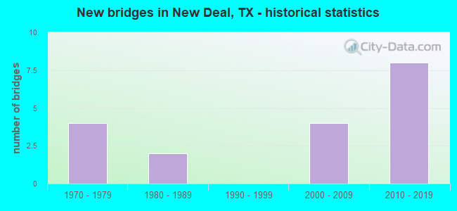
- New bridges - historical statistics
- 41970-1979
- 21980-1989
- 42000-2009
- 82010-2019


- Bridge Condition - Deck
- 66.7%Good
- 33.3%Satisfactory

- Bridge Condition - Superstructure
- 22.2%Very good
- 55.6%Good
- 11.1%Satisfactory
- 11.1%Fair

- Bridge Condition - Substructure
- 77.8%Good
- 22.2%Satisfactory
Find on map >> Show street view
Structure Number: 5152000670706, Location: 0.60 MI N OF FM 1729 (Lat: 33.743519, Lng: -101.838789), Route carried "on" structure: Interstate 27, Year Built: 2003, Status: Open, Structure Length: 4.57m (14.99ft), Average Daily Traffic: 9,111 (year 2019), Truck Traffic: 18%, Average Future Daily Traffic: 9,650 (year 2033), Design Load: HS 20, Features Intersected: NORTH LOOP 461
Minimum Vertical Clearance: 30+ m (98+ ft), Kilometerpoint: 31.149, Lanes on structure: 2, Lanes under structure: 4, Owner: State Highway Agency, Approaching Roadway Width: 11.6m (38.1ft), Skew: 2 degrees, Material/Design: Prestressed concrete, Design/Construction: Box Beam or Girders - Multiple, Number Of Spans In Main Unit: 2, Length of Maximum Span: 22.9m (75.1ft), Curb-To-Curb Width: 12.0m (39.4ft), Out-to-Out Width: 12.9m (42.3ft)
Condition: Deck: Good, Superstructure: Good, Substructure: Good, Operating Rating: 54.4 metric tons, Method Used To Determine Operating Rating: Assigned rating based on Load Factor Design (LFD) reported in metric tons, Inventory Rating: 32.7 metric tons, Method Used To Determine Inventory Rating: Assigned rating based on Load Factor Design (LFD) reported in metric tons, Structural Evaluation: Better than present minimum criteria, Deck Geometry: Equal to present minimum criteria, Underclear: High priority of corrective action, Approach Roadway Alignment: Equal to present desirable criteria, Length Of Structure Improvement: 4.60m (15.09ft), Designated Inspection Frequency: Every 24 months, Inspection Date: July 2021, Deck Structure Type: Concrete Cast-file-Place
Find on map >> Show street view
Structure Number: 51520006707061, Location: 0.60 MI N OF FM 1729 (Lat: 33.743467, Lng: -101.838603), Route carried "on" structure: Interstate 27, Year Built: 2003, Status: Open, Structure Length: 4.57m (14.99ft), Average Daily Traffic: 9,371 (year 2019), Truck Traffic: 18%, Average Future Daily Traffic: 9,650 (year 2033), Design Load: HS 20, Features Intersected: NORTH LOOP 461
Minimum Vertical Clearance: 30+ m (98+ ft), Kilometerpoint: 31.149, Lanes on structure: 2, Lanes under structure: 4, Owner: State Highway Agency, Approaching Roadway Width: 11.6m (38.1ft), Skew: 2 degrees, Material/Design: Prestressed concrete, Design/Construction: Box Beam or Girders - Multiple, Number Of Spans In Main Unit: 2, Length of Maximum Span: 22.9m (75.1ft), Curb-To-Curb Width: 12.0m (39.4ft), Out-to-Out Width: 12.9m (42.3ft)
Condition: Deck: Good, Superstructure: Good, Substructure: Good, Operating Rating: 54.4 metric tons, Method Used To Determine Operating Rating: Assigned rating based on Load Factor Design (LFD) reported in metric tons, Inventory Rating: 32.7 metric tons, Method Used To Determine Inventory Rating: Assigned rating based on Load Factor Design (LFD) reported in metric tons, Structural Evaluation: Better than present minimum criteria, Deck Geometry: Equal to present minimum criteria, Underclear: High priority of corrective action, Approach Roadway Alignment: Equal to present desirable criteria, Designated Inspection Frequency: Every 24 months, Inspection Date: July 2021, Deck Structure Type: Concrete Cast-file-Place
Find on map >> Show street view
Structure Number: 51520006707088, Location: 2.0 MI S OF FM 1729 (Lat: 33.708556, Lng: -101.840017), Route carried "on" structure: Interstate 27, Year Built: 1978, Status: Open, Structure Length: 6.92m (22.70ft), Average Daily Traffic: 9,741 (year 2019), Truck Traffic: 16%, Average Future Daily Traffic: 11,620 (year 2033), Design Load: HS 20, Features Intersected: COUNTY ROAD 58
Minimum Vertical Clearance: 30+ m (98+ ft), Kilometerpoint: 26.923, Lanes on structure: 2, Lanes under structure: 3, Owner: State Highway Agency, Approaching Roadway Width: 11.6m (38.1ft), Material/Design: Prestressed concrete continuous, Design/Construction: Stringer/Multi-beam, Number Of Spans In Main Unit: 1, Number Of Approach Spans: 2, Length of Maximum Span: 32.6m (107.0ft), Curb-To-Curb Width: 13.0m (42.7ft), Out-to-Out Width: 13.5m (44.3ft)
Condition: Deck: Good, Superstructure: Satisfactory, Substructure: Satisfactory, Operating Rating: 54.4 metric tons, Method Used To Determine Operating Rating: Assigned rating based on Load Factor Design (LFD) reported in metric tons, Inventory Rating: 32.7 metric tons, Method Used To Determine Inventory Rating: Assigned rating based on Load Factor Design (LFD) reported in metric tons, Structural Evaluation: Equal to present minimum criteria, Deck Geometry: Superior to present desirable criteria, Underclear: Better than present minimum criteria, Approach Roadway Alignment: Equal to present desirable criteria, Designated Inspection Frequency: Every 24 months, Inspection Date: July 2021, Deck Structure Type: Concrete Cast-file-Place, Wearing Surface/Protective System: Wearing Surface: Bituminous
Find on map >> Show street view
Structure Number: 51520006707089, Location: 2.0 MI S OF FM 1729 (Lat: 33.708561, Lng: -101.840236), Route carried "on" structure: Interstate 27, Year Built: 1978, Status: Open, Structure Length: 6.92m (22.70ft), Average Daily Traffic: 9,920 (year 2019), Truck Traffic: 16%, Average Future Daily Traffic: 11,620 (year 2033), Design Load: HS 20, Features Intersected: COUNTY ROAD 58
Minimum Vertical Clearance: 30+ m (98+ ft), Kilometerpoint: 26.923, Lanes on structure: 2, Lanes under structure: 3, Owner: State Highway Agency, Approaching Roadway Width: 11.6m (38.1ft), Material/Design: Prestressed concrete continuous, Design/Construction: Stringer/Multi-beam, Number Of Spans In Main Unit: 1, Number Of Approach Spans: 2, Length of Maximum Span: 32.6m (107.0ft), Curb-To-Curb Width: 13.0m (42.7ft), Out-to-Out Width: 13.5m (44.3ft)
Condition: Deck: Satisfactory, Superstructure: Fair, Substructure: Satisfactory, Operating Rating: 54.4 metric tons, Method Used To Determine Operating Rating: Assigned rating based on Load Factor Design (LFD) reported in metric tons, Inventory Rating: 32.7 metric tons, Method Used To Determine Inventory Rating: Assigned rating based on Load Factor Design (LFD) reported in metric tons, Structural Evaluation: Somewhat better than minimum adequacy, Deck Geometry: Superior to present desirable criteria, Underclear: Superior to present desirable criteria, Approach Roadway Alignment: Equal to present desirable criteria, Designated Inspection Frequency: Every 24 months, Inspection Date: July 2021, Deck Structure Type: Concrete Cast-file-Place, Wearing Surface/Protective System: Wearing Surface: Bituminous
Find on map >> Show street view
Structure Number: 51520006707093, Location: 3.00 MI N OF FM 1729 (Lat: 33.780992, Lng: -101.837225), Route carried "on" structure: County highway 53, Year Built: 1980, Status: Open, Structure Length: 15.88m (52.10ft), Average Daily Traffic: 100 (year 2017), Truck Traffic: 10%, Average Future Daily Traffic: 200 (year 2030), Design Load: HS 20, Features Intersected: IH 27 and AT & SF RR
Minimum Vertical Clearance: 30+ m (98+ ft), Kilometerpoint: 0.161, Lanes on structure: 2, Lanes under structure: 8, Owner: State Highway Agency, Approaching Roadway Width: 9.8m (32.2ft), Material/Design: Prestressed concrete continuous, Design/Construction: Stringer/Multi-beam, Number Of Spans In Main Unit: 5, Number Of Approach Spans: 2, Length of Maximum Span: 26.5m (86.9ft), Curb-To-Curb Width: 10.4m (34.1ft), Out-to-Out Width: 11.0m (36.1ft)
Condition: Deck: Good, Superstructure: Good, Substructure: Good, Operating Rating: 54.4 metric tons, Method Used To Determine Operating Rating: Assigned rating based on Load Factor Design (LFD) reported in metric tons, Inventory Rating: 32.7 metric tons, Method Used To Determine Inventory Rating: Assigned rating based on Load Factor Design (LFD) reported in metric tons, Structural Evaluation: Better than present minimum criteria, Deck Geometry: Superior to present desirable criteria, Underclear: Equal to present minimum criteria, Approach Roadway Alignment: Equal to present desirable criteria, Designated Inspection Frequency: Every 24 months, Inspection Date: October 2021, Deck Structure Type: Concrete Cast-file-Place, Wearing Surface/Protective System: Wearing Surface: Bituminous
Find on map >> Show street view
Structure Number: 51520006707216, Location: 1.05 MI S OF FM 1729 (Lat: 33.722656, Lng: -101.840239), Route carried "on" structure: Interstate 27, Year Built: 2010, Status: Open, Structure Length: 4.27m (14.01ft), Average Daily Traffic: 9,439 (year 2019), Truck Traffic: 21%, Average Future Daily Traffic: 10,450 (year 2035), Design Load: HL 93, Features Intersected: SOUTH LOOP 461
Minimum Vertical Clearance: 30+ m (98+ ft), Kilometerpoint: 28.321, Lanes on structure: 2, Lanes under structure: 4, Base Highway Network: Yes, Owner: State Highway Agency, Approaching Roadway Width: 11.6m (38.1ft), Material/Design: Prestressed concrete, Design/Construction: Box Beam or Girders - Multiple, Number Of Spans In Main Unit: 2, Length of Maximum Span: 21.3m (69.9ft), Curb-To-Curb Width: 12.2m (40.0ft), Out-to-Out Width: 12.9m (42.3ft)
Condition: Deck: Satisfactory, Superstructure: Very good, Substructure: Good, Operating Rating: 54.4 metric tons, Method Used To Determine Operating Rating: Assigned ratings based on Load and Resistance Factor Design (LRFD) reported in metric tons, Inventory Rating: 32.7 metric tons, Method Used To Determine Inventory Rating: Assigned ratings based on Load and Resistance Factor Design (LRFD) reported in metric tons, Structural Evaluation: Better than present minimum criteria, Deck Geometry: Better than present minimum criteria, Underclear: High priority of corrective action, Approach Roadway Alignment: Equal to present desirable criteria, Designated Inspection Frequency: Every 24 months, Inspection Date: November 2021, Deck Structure Type: Concrete Cast-file-Place
Find on map >> Show street view
Structure Number: 51520006707217, Location: 1.05 MI S OF FM 1729 (Lat: 33.722558, Lng: -101.840458), Route carried "on" structure: Interstate 27, Year Built: 2010, Status: Open, Structure Length: 4.27m (14.01ft), Average Daily Traffic: 9,536 (year 2019), Truck Traffic: 21%, Average Future Daily Traffic: 10,450 (year 2035), Design Load: HL 93, Features Intersected: SOUTH LOOP 461
Minimum Vertical Clearance: 30+ m (98+ ft), Kilometerpoint: 28.321, Lanes on structure: 2, Lanes under structure: 4, Base Highway Network: Yes, Owner: State Highway Agency, Approaching Roadway Width: 11.6m (38.1ft), Material/Design: Prestressed concrete, Design/Construction: Box Beam or Girders - Multiple, Number Of Spans In Main Unit: 2, Length of Maximum Span: 21.3m (69.9ft), Curb-To-Curb Width: 12.2m (40.0ft), Out-to-Out Width: 12.9m (42.3ft)
Condition: Deck: Satisfactory, Superstructure: Very good, Substructure: Good, Operating Rating: 54.4 metric tons, Method Used To Determine Operating Rating: Assigned ratings based on Load and Resistance Factor Design (LRFD) reported in metric tons, Inventory Rating: 32.7 metric tons, Method Used To Determine Inventory Rating: Assigned ratings based on Load and Resistance Factor Design (LRFD) reported in metric tons, Structural Evaluation: Better than present minimum criteria, Deck Geometry: Better than present minimum criteria, Underclear: High priority of corrective action, Approach Roadway Alignment: Equal to present desirable criteria, Designated Inspection Frequency: Every 24 months, Inspection Date: November 2021, Deck Structure Type: Concrete Cast-file-Place
Find on map >> Show street view
Structure Number: 51520006707218, Location: 3.05 MI N OF FM 1294 (Lat: 33.737558, Lng: -101.841542), Route carried "on" structure: Interstate 27, Year Built: 2010, Status: Open, Structure Length: 4.57m (14.99ft), Average Daily Traffic: 9,111 (year 2019), Truck Traffic: 22%, Average Future Daily Traffic: 9,550 (year 2035), Design Load: HL 93, Features Intersected: FM 1729
Minimum Vertical Clearance: 30+ m (98+ ft), Kilometerpoint: 30.005, Lanes on structure: 2, Lanes under structure: 4, Owner: State Highway Agency, Approaching Roadway Width: 11.6m (38.1ft), Skew: 1 degrees, Material/Design: Prestressed concrete, Design/Construction: Box Beam or Girders - Multiple, Number Of Spans In Main Unit: 2, Length of Maximum Span: 22.9m (75.1ft), Curb-To-Curb Width: 12.0m (39.4ft), Out-to-Out Width: 12.9m (42.3ft)
Condition: Deck: Good, Superstructure: Good, Substructure: Good, Operating Rating: 54.4 metric tons, Method Used To Determine Operating Rating: Assigned ratings based on Load and Resistance Factor Design (LRFD) reported in metric tons, Inventory Rating: 32.7 metric tons, Method Used To Determine Inventory Rating: Assigned ratings based on Load and Resistance Factor Design (LRFD) reported in metric tons, Structural Evaluation: Better than present minimum criteria, Deck Geometry: Equal to present minimum criteria, Underclear: Meets minimum limits, Approach Roadway Alignment: Equal to present desirable criteria, Designated Inspection Frequency: Every 24 months, Inspection Date: November 2021, Deck Structure Type: Concrete Cast-file-Place, Wearing Surface/Protective System: Deck Protection: Epoxy Coated Reinforcing
Find on map >> Show street view
Structure Number: 51520006707219, Location: 3.05 MI N OF FM 1294 (Lat: 33.737556, Lng: -101.841289), Route carried "on" structure: Interstate 27, Year Built: 2010, Status: Open, Structure Length: 4.57m (14.99ft), Average Daily Traffic: 9,371 (year 2019), Truck Traffic: 22%, Average Future Daily Traffic: 9,550 (year 2035), Design Load: HL 93, Features Intersected: FM 1729
Minimum Vertical Clearance: 30+ m (98+ ft), Kilometerpoint: 30.005, Lanes on structure: 2, Lanes under structure: 4, Owner: State Highway Agency, Approaching Roadway Width: 11.6m (38.1ft), Skew: 1 degrees, Material/Design: Prestressed concrete, Design/Construction: Box Beam or Girders - Multiple, Number Of Spans In Main Unit: 2, Length of Maximum Span: 22.9m (75.1ft), Curb-To-Curb Width: 12.0m (39.4ft), Out-to-Out Width: 12.9m (42.3ft)
Condition: Deck: Good, Superstructure: Good, Substructure: Good, Operating Rating: 54.4 metric tons, Method Used To Determine Operating Rating: Assigned ratings based on Load and Resistance Factor Design (LRFD) reported in metric tons, Inventory Rating: 32.7 metric tons, Method Used To Determine Inventory Rating: Assigned ratings based on Load and Resistance Factor Design (LRFD) reported in metric tons, Structural Evaluation: Better than present minimum criteria, Deck Geometry: Equal to present minimum criteria, Underclear: Meets minimum limits, Approach Roadway Alignment: Equal to present desirable criteria, Designated Inspection Frequency: Every 24 months, Inspection Date: November 2021, Deck Structure Type: Concrete Cast-file-Place, Wearing Surface/Protective System: Deck Protection: Epoxy Coated Reinforcing
Find on map >> Show street view
Structure Number: 5152000670706, Location: 0.60 MI N OF FM 1729 (Lat: 33.743500, Lng: -101.838700), Route carried "under" structure: State highway 461, Year Built: 2003, Structure Length: 0. m, Average Daily Traffic: 210 (year 2010), Truck Traffic: 25%, Features Intersected: NORTH LOOP 461, Facility Carried by Structure: IH 27 SB
Minimum Vertical Clearance: 5.18m (16.99ft), Kilometerpoint: 0.048, Lanes on structure: 4, Material/Design: Prestressed concrete, Design/Construction: Box Beam or Girders - Multiple, Length of Maximum Span: 22.9m (75.1ft)
Find on map >> Show street view
Structure Number: 51520006707061, Location: 0.60 MI N OF FM 1729 (Lat: 33.743400, Lng: -101.838600), Route carried "under" structure: State highway 461, Year Built: 2003, Structure Length: 0. m, Average Daily Traffic: 210 (year 2010), Truck Traffic: 25%, Features Intersected: NORTH LOOP 461, Facility Carried by Structure: IH 27 NB
Minimum Vertical Clearance: 5.28m (17.32ft), Kilometerpoint: 0.097, Lanes on structure: 4, Material/Design: Prestressed concrete, Design/Construction: Box Beam or Girders - Multiple, Length of Maximum Span: 22.9m (75.1ft)
Find on map >> Show street view
Structure Number: 51520006707088, Location: 2.0 MI S OF FM 1729 (Lat: 33.708500, Lng: -101.840000), Route carried "under" structure: County highway 58, Year Built: 1978, Structure Length: 0. m, Average Daily Traffic: 100 (year 2009), Features Intersected: COUNTY ROAD 58, Facility Carried by Structure: IH 27 NB
Minimum Vertical Clearance: 5.01m (16.44ft), Lanes on structure: 3, Material/Design: Prestressed concrete continuous, Design/Construction: Stringer/Multi-beam, Length of Maximum Span: 32.6m (107.0ft)
Find on map >> Show street view
Structure Number: 51520006707089, Location: 2.0 MI S OF FM 1729 (Lat: 33.708500, Lng: -101.840200), Route carried "under" structure: County highway 58, Year Built: 1978, Structure Length: 0. m, Average Daily Traffic: 100 (year 2009), Features Intersected: COUNTY ROAD 58, Facility Carried by Structure: IH 27 SB
Minimum Vertical Clearance: 5.08m (16.67ft), Lanes on structure: 3, Material/Design: Prestressed concrete continuous, Design/Construction: Stringer/Multi-beam, Length of Maximum Span: 32.6m (107.0ft)
Find on map >> Show street view
Structure Number: 51520006707093, Location: 3.00 MI N OF FM 1729 (Lat: 33.780992, Lng: -101.837225), Route carried "under" structure: Interstate 27, Year Built: 1980, Structure Length: 0. m, Average Daily Traffic: 13,790 (year 2013), Truck Traffic: 18%, Features Intersected: IH 27 and AT & SF RR, Facility Carried by Structure: CR 53
Minimum Vertical Clearance: 7.93m (26.02ft), Kilometerpoint: 35.105, Lanes on structure: 8, Material/Design: Prestressed concrete continuous, Design/Construction: Stringer/Multi-beam, Length of Maximum Span: 26.5m (86.9ft)
Find on map >> Show street view
Structure Number: 51520006707216, Location: 1.05 MI S OF FM 1729 (Lat: 33.722600, Lng: -101.840200), Route carried "under" structure: State highway 461, Year Built: 2010, Structure Length: 0. m, Average Daily Traffic: 850 (year 2010), Truck Traffic: 18%, Features Intersected: SOUTH LOOP 461, Facility Carried by Structure: IH 27 NB
Minimum Vertical Clearance: 5.13m (16.83ft), Kilometerpoint: 2.692, Lanes on structure: 4, Material/Design: Prestressed concrete, Design/Construction: Box Beam or Girders - Multiple, Length of Maximum Span: 21.3m (69.9ft)
Find on map >> Show street view
Structure Number: 51520006707217, Location: 1.05 MI S OF FM 1729 (Lat: 33.722500, Lng: -101.840400), Route carried "under" structure: State highway 461, Year Built: 2010, Structure Length: 0. m, Average Daily Traffic: 850 (year 2010), Truck Traffic: 18%, Features Intersected: SOUTH LOOP 461, Facility Carried by Structure: IH 27 SB
Minimum Vertical Clearance: 5.18m (16.99ft), Kilometerpoint: 2.715, Lanes on structure: 4, Material/Design: Prestressed concrete, Design/Construction: Box Beam or Girders - Multiple, Length of Maximum Span: 21.3m (69.9ft)
Structure Number: 51520006707218, Location: 3.05 MI N OF FM 1294, Route carried "under" structure: State highway 1729, Year Built: 2010, Structure Length: 0. m, Average Daily Traffic: 1,300 (year 2010), Truck Traffic: 17%, Features Intersected: FM 1729, Facility Carried by Structure: IH 27 SB
Minimum Vertical Clearance: 5.18m (16.99ft), Kilometerpoint: 25.193, Lanes on structure: 4, Material/Design: Prestressed concrete, Design/Construction: Box Beam or Girders - Multiple, Length of Maximum Span: 22.9m (75.1ft)
Minimum Vertical Clearance: 5.18m (16.99ft), Kilometerpoint: 25.193, Lanes on structure: 4, Material/Design: Prestressed concrete, Design/Construction: Box Beam or Girders - Multiple, Length of Maximum Span: 22.9m (75.1ft)
Structure Number: 51520006707219, Location: 3.05 MI N OF FM 1294, Route carried "under" structure: State highway 1729, Year Built: 2010, Structure Length: 0. m, Average Daily Traffic: 980 (year 2010), Truck Traffic: 22%, Features Intersected: FM 1729, Facility Carried by Structure: IH 27 NB
Minimum Vertical Clearance: 5.08m (16.67ft), Kilometerpoint: 25.233, Lanes on structure: 4, Material/Design: Prestressed concrete, Design/Construction: Box Beam or Girders - Multiple, Length of Maximum Span: 22.9m (75.1ft)
Minimum Vertical Clearance: 5.08m (16.67ft), Kilometerpoint: 25.233, Lanes on structure: 4, Material/Design: Prestressed concrete, Design/Construction: Box Beam or Girders - Multiple, Length of Maximum Span: 22.9m (75.1ft)