Bridge Statistics for New Kensington, Pennsylvania (PA)
Condition, Traffic, Stress, Structural Evaluation, Project Costs
- National Bridge Inventory (NBI) Statistics
- 18Number of bridges
- 92ft / 28.4mTotal length
- $597,000Total costs
- 133,090Total average daily traffic
- 19,683Total average daily truck traffic
- National Bridge Inventory (NBI) Registered Bridges for New Kensington
- No street view available for this location
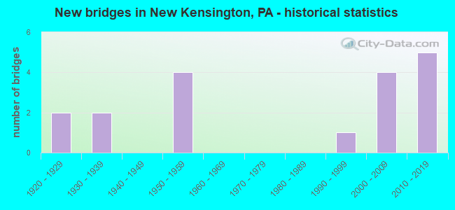
- New bridges - historical statistics
- 21920-1929
- 21930-1939
- 41950-1959
- 11990-1999
- 42000-2009
- 52010-2019
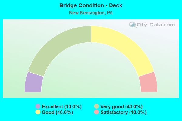
- Bridge Condition - Deck
- 10.0%Excellent
- 40.0%Very good
- 40.0%Good
- 10.0%Satisfactory
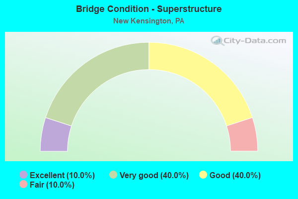
- Bridge Condition - Superstructure
- 10.0%Excellent
- 40.0%Very good
- 40.0%Good
- 10.0%Fair
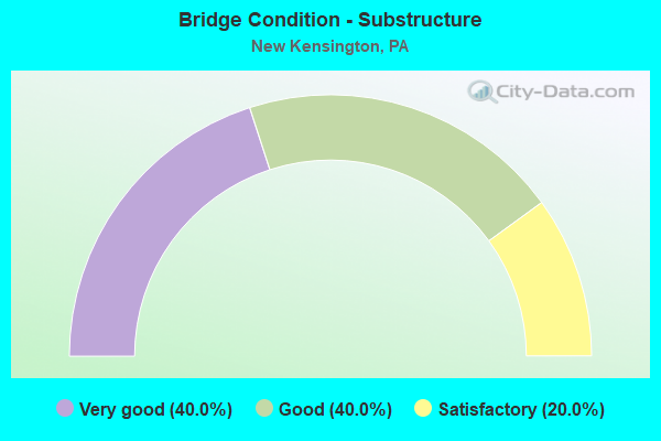
- Bridge Condition - Substructure
- 40.0%Very good
- 40.0%Good
- 20.0%Satisfactory
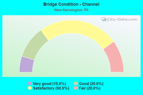
- Bridge Condition - Channel
- 10.0%Very good
- 20.0%Good
- 50.0%Satisfactory
- 20.0%Fair
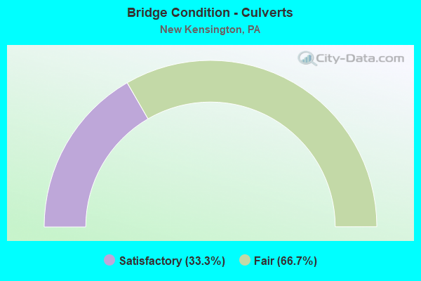
- Bridge Condition - Culverts
- 33.3%Satisfactory
- 66.7%Fair
Find on map >> Show street view
Structure Number: 36, Location: SW OF GETTYSBURG (Lat: 39.740572, Lng: -77.428428), Route carried "on" structure: State highway 16, Year Built: 1939, Year Reconstructed: 2011, Status: Open, Structure Length: 1.04m (3.41ft), Average Daily Traffic: 6,232 (year 2022), Truck Traffic: 11%, Average Future Daily Traffic: 7,815 (year 2032), Design Load: H 20, Features Intersected: MINEY BRANCH OF TOMS CRK
Minimum Vertical Clearance: 30+ m (98+ ft), Kilometerpoint: 2.203, Lanes on structure: 2, Base Highway Network: Yes, Owner: State Highway Agency, Approaching Roadway Width: 11.3m (37.1ft), Skew: 3 degrees, Material/Design: Prestressed concrete, Design/Construction: Box Beam or Girders - Single/Spread, Number Of Spans In Main Unit: 1, Length of Maximum Span: 9.4m (30.8ft), Curb-To-Curb Width: 14.3m (46.9ft), Out-to-Out Width: 15.2m (49.9ft)
Condition: Deck: Good, Superstructure: Good, Substructure: Satisfactory, Channel: Satisfactory, Operating Rating: 77.1 metric tons, Method Used To Determine Operating Rating: Load Factor (LF), Inventory Rating: 32.7 metric tons, Method Used To Determine Inventory Rating: Load Factor (LF), Structural Evaluation: Equal to present minimum criteria, Deck Geometry: Superior to present desirable criteria, Waterway Adequacy: Equal to present minimum criteria, Approach Roadway Alignment: Better than present minimum criteria, Length Of Structure Improvement: 1.70m (5.58ft), Designated Inspection Frequency: Every 24 months, Inspection Date: June 2021, Bridge Improvement Cost: $23,000, Roadway Improvement Cost: $67,000, Total Project Cost: $307,000, Deck Structure Type: Concrete Cast-file-Place, Wearing Surface/Protective System: Wearing Surface: Monolithic Concrete, Deck Protection: Epoxy Coated Reinforcing
Find on map >> Show street view
Structure Number: 4441, Location: EVERETT (Lat: 40.002592, Lng: -78.373353), Route carried "on" structure: Interstate 76, Year Built: 1939, Status: Open, Structure Length: 1.28m (4.20ft), Average Daily Traffic: 33,684 (year 2001), Truck Traffic: 36%, Average Future Daily Traffic: 38,535 (year 2030), Design Load: HS 20, Features Intersected: SR 2025, LR 05123
Minimum Vertical Clearance: 30+ m (98+ ft), Kilometerpoint: 0.000, Lanes on structure: 4, Lanes under structure: 2, Base Highway Network: Yes, Toll: On toll road, Owner: State Toll Authority, Approaching Roadway Width: 23.8m (78.1ft), Skew: 31 degrees, Material/Design: Concrete, Design/Construction: Culvert, Number Of Spans In Main Unit: 1, Length of Maximum Span: 11.0m (36.1ft)
Condition: Culverts: Fair, Operating Rating: 89.8 metric tons, Method Used To Determine Operating Rating: Load Factor (LF), Inventory Rating: 89.8 metric tons, Method Used To Determine Inventory Rating: Load Factor (LF), Structural Evaluation: Somewhat better than minimum adequacy, Underclear: High priority of corrective action, Approach Roadway Alignment: Equal to present desirable criteria, Length Of Structure Improvement: 1.80m (5.91ft), Designated Inspection Frequency: Every 24 months, Inspection Date: September 2020
Find on map >> Show street view
Structure Number: 36, Location: CITY OF NEW KENSINGTON (Lat: 40.563667, Lng: -79.756403), Route carried "on" structure: State highway 56, Year Built: 1956, Year Reconstructed: 2008, Status: Open, Structure Length: 1.49m (4.89ft), Average Daily Traffic: 8,459 (year 2022), Truck Traffic: 4%, Average Future Daily Traffic: 12,716 (year 2032), Design Load: HS 20+Mod, Features Intersected: LITTLE PUCKETA CREEK
Minimum Vertical Clearance: 30+ m (98+ ft), Kilometerpoint: 0.360, Lanes on structure: 2, Base Highway Network: Yes, Owner: State Highway Agency, Approaching Roadway Width: 8.8m (28.9ft), Material/Design: Steel, Design/Construction: Stringer/Multi-beam, Number Of Spans In Main Unit: 1, Length of Maximum Span: 14.0m (45.9ft), Curb or Sidewalk Widths: Left: 0.1m (0.3ft), Right: 1.5m (4.9ft), Curb-To-Curb Width: 8.8m (28.9ft), Out-to-Out Width: 11.2m (36.7ft)
Condition: Deck: Very good, Superstructure: Good, Substructure: Good, Channel: Satisfactory, Inventory Rating: 61.7 metric tons, Method Used To Determine Inventory Rating: Load Factor (LF), Structural Evaluation: Better than present minimum criteria, Deck Geometry: High priority of replacement, Waterway Adequacy: Equal to present desirable criteria, Approach Roadway Alignment: Equal to present desirable criteria, Length Of Structure Improvement: 2.20m (7.22ft), Designated Inspection Frequency: Every 48 months, Inspection Date: April 2021, Bridge Improvement Cost: $6,000, Roadway Improvement Cost: $18,000, Total Project Cost: $81,000, Deck Structure Type: Concrete Cast-file-Place, Wearing Surface/Protective System: Wearing Surface: Monolithic Concrete, Deck Protection: Epoxy Coated Reinforcing
Find on map >> Show street view
Structure Number: 36004, Location: CITY OF NEW KENSINGTON (Lat: 40.575261, Lng: -79.742419), Route carried "on" structure: State highway 56, Year Built: 1958, Status: Open, Structure Length: 1.46m (4.79ft), Average Daily Traffic: 9,810 (year 2020), Truck Traffic: 9%, Average Future Daily Traffic: 18,313 (year 2032), Design Load: H 20, Features Intersected: LITTLE PUCKETA CREEK
Minimum Vertical Clearance: 30+ m (98+ ft), Kilometerpoint: 3.315, Lanes on structure: 4, Base Highway Network: Yes, Owner: State Highway Agency, Approaching Roadway Width: 21.9m (71.9ft), Skew: 23 degrees, Material/Design: Concrete, Design/Construction: Culvert, Number Of Spans In Main Unit: 1, Length of Maximum Span: 11.6m (38.1ft)
Condition: Channel: Satisfactory, Culverts: Satisfactory, Operating Rating: 89.8 metric tons, Method Used To Determine Operating Rating: Load Factor (LF), Inventory Rating: 89.8 metric tons, Method Used To Determine Inventory Rating: Load Factor (LF), Structural Evaluation: Equal to present minimum criteria, Waterway Adequacy: Superior to present desirable criteria, Approach Roadway Alignment: Equal to present desirable criteria, Length Of Structure Improvement: 1.80m (5.91ft), Designated Inspection Frequency: Every 48 months, Inspection Date: April 2021
Find on map >> Show street view
Structure Number: 36005, Location: CITY OF NEW KENSINGTON (Lat: 40.576750, Lng: -79.737856), Route carried "on" structure: State highway 56, Year Built: 1958, Status: Open, Structure Length: 1.65m (5.41ft), Average Daily Traffic: 9,810 (year 2020), Truck Traffic: 9%, Average Future Daily Traffic: 18,313 (year 2032), Design Load: H 20, Features Intersected: LITTLE PUCKETA CREEK
Minimum Vertical Clearance: 30+ m (98+ ft), Kilometerpoint: 3.315, Lanes on structure: 4, Base Highway Network: Yes, Owner: State Highway Agency, Approaching Roadway Width: 26.8m (87.9ft), Skew: 24 degrees, Material/Design: Concrete, Design/Construction: Culvert, Number Of Spans In Main Unit: 1, Length of Maximum Span: 11.6m (38.1ft)
Condition: Channel: Fair, Culverts: Fair, Operating Rating: 89.8 metric tons, Method Used To Determine Operating Rating: Load Factor (LF), Inventory Rating: 89.8 metric tons, Method Used To Determine Inventory Rating: Load Factor (LF), Structural Evaluation: Somewhat better than minimum adequacy, Waterway Adequacy: Superior to present desirable criteria, Approach Roadway Alignment: Equal to present desirable criteria, Length Of Structure Improvement: 2.20m (7.22ft), Designated Inspection Frequency: Every 24 months, Inspection Date: April 2021
Find on map >> Show street view
Structure Number: 36769, Location: CITY OF NEW KENSINGTON (Lat: 40.576831, Lng: -79.735303), Route carried "on" structure: State highway , Year Built: 1958, Status: Open, Structure Length: 1.40m (4.59ft), Average Daily Traffic: 912 (year 2020), Truck Traffic: 2%, Average Future Daily Traffic: 8,686 (year 2032), Design Load: HS 20, Features Intersected: LITTLE PUCKETA CREEK, Facility Carried by Structure: SR 4083
Minimum Vertical Clearance: 30+ m (98+ ft), Kilometerpoint: 2.929, Lanes on structure: 2, Owner: State Highway Agency, Approaching Roadway Width: 9.1m (29.9ft), Skew: 2 degrees, Material/Design: Concrete, Design/Construction: Tee Beam, Number Of Spans In Main Unit: 1, Length of Maximum Span: 13.4m (44.0ft), Curb or Sidewalk Widths: Left: 0.5m (1.6ft), Right: 0.5m (1.6ft), Curb-To-Curb Width: 9.1m (29.9ft), Out-to-Out Width: 10.8m (35.4ft)
Condition: Deck: Satisfactory, Superstructure: Fair, Substructure: Satisfactory, Channel: Fair, Operating Rating: 68.9 metric tons, Method Used To Determine Operating Rating: Load Factor (LF), Inventory Rating: 40.8 metric tons, Method Used To Determine Inventory Rating: Load Factor (LF), Structural Evaluation: Somewhat better than minimum adequacy, Deck Geometry: Equal to present minimum criteria, Waterway Adequacy: Superior to present desirable criteria, Approach Roadway Alignment: Equal to present desirable criteria, Length Of Structure Improvement: 2.10m (6.89ft), Designated Inspection Frequency: Every 24 months, Inspection Date: Febuary 2020, Bridge Improvement Cost: $5,000, Roadway Improvement Cost: $16,000, Total Project Cost: $72,000, Deck Structure Type: Concrete Cast-file-Place, Wearing Surface/Protective System: Wearing Surface: Bituminous
Find on map >> Show street view
Structure Number: 36994, Location: 100' EAST OF SR 366 (Lat: 40.557411, Lng: -79.758994), Route carried "on" structure: City street , Year Built: 1999, Status: Open, Structure Length: 1.43m (4.69ft), Average Daily Traffic: 550 (year 2012), Truck Traffic: 5%, Average Future Daily Traffic: 700 (year 2032), Design Load: HL 93, Features Intersected: LITTLE PUCKETA CREEK, Facility Carried by Structure: FOURTH STREET
Minimum Vertical Clearance: 30+ m (98+ ft), Kilometerpoint: 0.000, Lanes on structure: 2, Owner: City or Municipal Highway Agency, Approaching Roadway Width: 7.3m (24.0ft), Material/Design: Prestressed concrete, Design/Construction: Box Beam or Girders - Single/Spread, Number Of Spans In Main Unit: 1, Length of Maximum Span: 14.0m (45.9ft), Curb or Sidewalk Widths: Left: 0.1m (0.3ft), Right: 1.4m (4.6ft), Curb-To-Curb Width: 7.6m (24.9ft), Out-to-Out Width: 9.8m (32.2ft)
Condition: Deck: Good, Superstructure: Good, Substructure: Good, Channel: Good, Inventory Rating: 55.3 metric tons, Method Used To Determine Inventory Rating: Load Factor (LF), Structural Evaluation: Better than present minimum criteria, Deck Geometry: Meets minimum limits, Waterway Adequacy: Better than present minimum criteria, Approach Roadway Alignment: Meets minimum limits, Length Of Structure Improvement: 2.10m (6.89ft), Designated Inspection Frequency: Every 24 months, Inspection Date: November 2020, Bridge Improvement Cost: $10,000, Roadway Improvement Cost: $30,000, Total Project Cost: $137,000, Deck Structure Type: Concrete Cast-file-Place, Wearing Surface/Protective System: Wearing Surface: Monolithic Concrete, Deck Protection: Epoxy Coated Reinforcing
Find on map >> Show street view
Structure Number: 41979, Location: BTW 11TH AND KENNETH AVE (Lat: 40.569594, Lng: -79.765064), Route carried "on" structure: City street LC0T, Year Built: 2003, Status: Open, Structure Length: 7.83m (25.69ft), Average Daily Traffic: 3,815 (year 2012), Truck Traffic: 2%, Average Future Daily Traffic: 4,500 (year 2032), Design Load: HL 93, Features Intersected: RR/CONSTITUTION BLVD, Facility Carried by Structure: LOCUST STREET
Minimum Vertical Clearance: 30+ m (98+ ft), Kilometerpoint: 0.000, Lanes on structure: 2, Lanes under structure: 2, Owner: City or Municipal Highway Agency, Approaching Roadway Width: 7.9m (25.9ft), Material/Design: Prestressed concrete, Design/Construction: Box Beam or Girders - Single/Spread, Number Of Spans In Main Unit: 1, Number Of Approach Spans: 2, Length of Maximum Span: 32.0m (105.0ft), Curb or Sidewalk Widths: Left: 0.2m (0.7ft), Right: 1.5m (4.9ft), Curb-To-Curb Width: 7.9m (25.9ft), Out-to-Out Width: 10.2m (33.5ft)
Condition: Deck: Good, Superstructure: Good, Substructure: Good, Operating Rating: 67.1 metric tons, Method Used To Determine Operating Rating: Load and Resistance Factor (LRFR), Inventory Rating: 41.7 metric tons, Method Used To Determine Inventory Rating: Load and Resistance Factor (LRFR), Structural Evaluation: Better than present minimum criteria, Deck Geometry: High priority of corrective action, Underclear: Better than present minimum criteria, Approach Roadway Alignment: Better than present minimum criteria, Designated Inspection Frequency: Every 24 months, Inspection Date: November 2020, Deck Structure Type: Concrete Cast-file-Place, Wearing Surface/Protective System: Wearing Surface: Monolithic Concrete, Deck Protection: Epoxy Coated Reinforcing
Find on map >> Show street view
Structure Number: 4441, Location: 0.1 MILES N OF SR 4085 (Lat: 40.552839, Lng: -79.758567), Route carried "on" structure: State highway 56T, Year Built: 2006, Status: Open, Structure Length: 0.91m (2.99ft), Average Daily Traffic: 5,551 (year 2020), Truck Traffic: 13%, Average Future Daily Traffic: 10,647 (year 2032), Design Load: HL 93, Features Intersected: LITTLE PUCKETA CREEK, Facility Carried by Structure: SR 4087
Minimum Vertical Clearance: 30+ m (98+ ft), Kilometerpoint: 0.000, Lanes on structure: 3, Owner: State Highway Agency, Approaching Roadway Width: 11.1m (36.4ft), Skew: 20 degrees, Material/Design: Prestressed concrete, Design/Construction: Box Beam or Girders - Single/Spread, Number Of Spans In Main Unit: 1, Length of Maximum Span: 8.5m (27.9ft), Curb or Sidewalk Widths: Left: 2.0m (6.6ft), Right: 0.0m, Curb-To-Curb Width: 11.1m (36.4ft), Out-to-Out Width: 23.0m (75.5ft)
Condition: Deck: Very good, Superstructure: Very good, Substructure: Very good, Channel: Very good, Operating Rating: 56.2 metric tons, Method Used To Determine Operating Rating: Load and Resistance Factor (LRFR), Inventory Rating: 33.6 metric tons, Method Used To Determine Inventory Rating: Load and Resistance Factor (LRFR), Structural Evaluation: Equal to present desirable criteria, Deck Geometry: High priority of replacement, Waterway Adequacy: Superior to present desirable criteria, Approach Roadway Alignment: Equal to present desirable criteria, Designated Inspection Frequency: Every 24 months, Inspection Date: Febuary 2020, Deck Structure Type: Concrete Cast-file-Place, Wearing Surface/Protective System: Wearing Surface: Monolithic Concrete, Deck Protection: Epoxy Coated Reinforcing
Find on map >> Show street view
Structure Number: 45498, Location: City of New Kensington (Lat: 40.553981, Lng: -79.757806), Route carried "on" structure: State highway 366, Year Built: 2007, Status: Open, Structure Length: 1.34m (4.40ft), Average Daily Traffic: 5,379 (year 2020), Truck Traffic: 11%, Average Future Daily Traffic: 7,735 (year 2032), Design Load: HL 93, Features Intersected: Little Pucketa Creek
Minimum Vertical Clearance: 30.45m (99.90ft), Kilometerpoint: 1.926, Lanes on structure: 5, Base Highway Network: Yes, Owner: State Highway Agency, Approaching Roadway Width: 20.1m (65.9ft), Skew: 1 degrees, Material/Design: Prestressed concrete, Design/Construction: Box Beam or Girders - Single/Spread, Number Of Spans In Main Unit: 1, Length of Maximum Span: 12.8m (42.0ft), Curb or Sidewalk Widths: Left: 2.0m (6.6ft), Right: 2.0m (6.6ft), Curb-To-Curb Width: 20.1m (65.9ft), Out-to-Out Width: 24.8m (81.4ft)
Condition: Deck: Very good, Superstructure: Very good, Substructure: Good, Channel: Good, Operating Rating: 57.3 metric tons, Method Used To Determine Operating Rating: Assigned ratings based on Load and Resistance Factor Design (LRFD) reported by rating factor (RF) using HL93 loadings, Inventory Rating: 36.0 metric tons, Method Used To Determine Inventory Rating: Assigned ratings based on Load and Resistance Factor Design (LRFD) reported by rating factor (RF) using HL93 loadings, Structural Evaluation: Better than present minimum criteria, Deck Geometry: Somewhat better than minimum adequacy, Waterway Adequacy: Superior to present desirable criteria, Approach Roadway Alignment: Equal to present desirable criteria, Designated Inspection Frequency: Every 48 months, Inspection Date: June 2019, Deck Structure Type: Concrete Cast-file-Place, Wearing Surface/Protective System: Wearing Surface: Monolithic Concrete, Deck Protection: Epoxy Coated Reinforcing
Find on map >> Show street view
Structure Number: 4616, Location: 0.1 mi E of SR 0056 (Lat: 40.562492, Lng: -79.756347), Route carried "on" structure: State highway 366, Year Built: 2010, Status: Open, Structure Length: 2.13m (6.99ft), Average Daily Traffic: 5,379 (year 2020), Truck Traffic: 11%, Average Future Daily Traffic: 7,735 (year 2032), Design Load: HL 93, Features Intersected: Little Pucketa Creek
Minimum Vertical Clearance: 30+ m (98+ ft), Kilometerpoint: 1.926, Lanes on structure: 4, Base Highway Network: Yes, Owner: State Highway Agency, Approaching Roadway Width: 18.3m (60.0ft), Skew: 4 degrees, Material/Design: Prestressed concrete, Design/Construction: Box Beam or Girders - Multiple, Number Of Spans In Main Unit: 1, Length of Maximum Span: 20.7m (67.9ft), Curb or Sidewalk Widths: Left: 0.1m (0.3ft), Right: 0.1m (0.3ft), Curb-To-Curb Width: 21.2m (69.6ft), Out-to-Out Width: 22.2m (72.8ft)
Condition: Deck: Good, Superstructure: Very good, Substructure: Very good, Channel: Satisfactory, Operating Rating: 68.0 metric tons, Method Used To Determine Operating Rating: Load and Resistance Factor (LRFR), Inventory Rating: 47.2 metric tons, Method Used To Determine Inventory Rating: Load and Resistance Factor (LRFR), Structural Evaluation: Equal to present desirable criteria, Deck Geometry: Superior to present desirable criteria, Waterway Adequacy: Superior to present desirable criteria, Approach Roadway Alignment: Equal to present desirable criteria, Designated Inspection Frequency: Every 48 months, Inspection Date: June 2019, Deck Structure Type: Concrete Cast-file-Place, Wearing Surface/Protective System: Wearing Surface: Monolithic Concrete, Deck Protection: Epoxy Coated Reinforcing
Find on map >> Show street view
Structure Number: 5241, Location: 0.2 mi W from SR 0056 (Lat: 40.574886, Lng: -79.749147), Route carried "on" structure: State highway 366, Year Built: 2015, Status: Open, Structure Length: 4.02m (13.19ft), Average Daily Traffic: 13,826 (year 2020), Truck Traffic: 2%, Average Future Daily Traffic: 18,900 (year 2042), Design Load: HL 93, Features Intersected: SR 0056
Minimum Vertical Clearance: 30+ m (98+ ft), Kilometerpoint: 1.221, Lanes on structure: 2, Lanes under structure: 3, Base Highway Network: Yes, Owner: State Highway Agency, Approaching Roadway Width: 11.6m (38.1ft), Skew: 21 degrees, Material/Design: Prestressed concrete, Design/Construction: Stringer/Multi-beam, Number Of Spans In Main Unit: 1, Length of Maximum Span: 39.3m (128.9ft), Curb or Sidewalk Widths: Left: 0.1m (0.3ft), Right: 0.1m (0.3ft), Curb-To-Curb Width: 15.8m (51.8ft), Out-to-Out Width: 16.9m (55.4ft)
Condition: Deck: Very good, Superstructure: Very good, Substructure: Very good, Operating Rating: 57.3 metric tons, Method Used To Determine Operating Rating: Assigned ratings based on Load and Resistance Factor Design (LRFD) reported by rating factor (RF) using HL93 loadings, Inventory Rating: 44.4 metric tons, Method Used To Determine Inventory Rating: Assigned ratings based on Load and Resistance Factor Design (LRFD) reported by rating factor (RF) using HL93 loadings, Structural Evaluation: Equal to present desirable criteria, Deck Geometry: Superior to present desirable criteria, Underclear: Equal to present minimum criteria, Approach Roadway Alignment: Better than present minimum criteria, Designated Inspection Frequency: Every 48 months, Inspection Date: May 2019, Deck Structure Type: Concrete Cast-file-Place, Wearing Surface/Protective System: Wearing Surface: Monolithic Concrete, Deck Protection: Epoxy Coated Reinforcing
Find on map >> Show street view
Structure Number: 53288, Location: CITY OF NEW KENSINGTON (Lat: 40.571508, Lng: -79.749606), Route carried "on" structure: State highway 56, Year Built: 2016, Status: Open, Structure Length: 2.44m (8.01ft), Average Daily Traffic: 15,546 (year 2020), Truck Traffic: 9%, Average Future Daily Traffic: 19,980 (year 2037), Design Load: HL 93, Features Intersected: LITTLE PUCKETA CREEK, Facility Carried by Structure: Stevenson Blvd
Minimum Vertical Clearance: 30+ m (98+ ft), Kilometerpoint: 1.946, Lanes on structure: 2, Base Highway Network: Yes, Owner: State Highway Agency, Maintenance Responsibility: Private, Approaching Roadway Width: 23.2m (76.1ft), Skew: 23 degrees, Material/Design: Prestressed concrete, Design/Construction: Box Beam or Girders - Single/Spread, Number Of Spans In Main Unit: 1, Length of Maximum Span: 23.2m (76.1ft), Curb-To-Curb Width: 24.9m (81.7ft), Out-to-Out Width: 25.5m (83.7ft)
Condition: Deck: Excellent, Superstructure: Excellent, Substructure: Very good, Channel: Satisfactory, Operating Rating: 57.3 metric tons, Method Used To Determine Operating Rating: Assigned ratings based on Load and Resistance Factor Design (LRFD) reported by rating factor (RF) using HL93 loadings, Inventory Rating: 44.4 metric tons, Method Used To Determine Inventory Rating: Assigned ratings based on Load and Resistance Factor Design (LRFD) reported by rating factor (RF) using HL93 loadings, Structural Evaluation: Equal to present desirable criteria, Deck Geometry: Superior to present desirable criteria, Waterway Adequacy: Superior to present desirable criteria, Approach Roadway Alignment: Equal to present desirable criteria, Designated Inspection Frequency: Every 24 months, Inspection Date: June 2020, Deck Structure Type: Concrete Cast-file-Place, Wearing Surface/Protective System: Wearing Surface: Integral Concrete, Deck Protection: Epoxy Coated Reinforcing
Find on map >> Show street view
Structure Number: 1475, Location: New Kensington Bridge (Lat: 40.563611, Lng: -79.774250), Route carried "under" structure: State highway , Year Built: 1927, Structure Length: 0. m, Average Daily Traffic: 1,155 (year 2022), Truck Traffic: 7%, Features Intersected: SR 9109,N&S ,PINE,ALLRIV, Facility Carried by Structure: New Kensington Brg
Minimum Vertical Clearance: 4.42m (14.50ft), Kilometerpoint: 21.832, Lanes on structure: 2, Lanes under structure: 1, Material/Design: Steel, Design/Construction: Truss - Thru, Length of Maximum Span: 112.8m (370.1ft)
Find on map >> Show street view
Structure Number: 1475, Location: New Kensington Bridge (Lat: 40.563611, Lng: -79.774250), Route carried "under" structure: City street , Year Built: 1927, Structure Length: 0. m, Average Daily Traffic: 100 (year 1997), Truck Traffic: 5%, Features Intersected: SR 9109,N&S ,PINE,ALLRIV, Facility Carried by Structure: New Kensington Brg
Minimum Vertical Clearance: 4.34m (14.24ft), Kilometerpoint: 0.000, Lanes on structure: 2, Lanes under structure: 2, Material/Design: Steel, Design/Construction: Truss - Thru, Length of Maximum Span: 112.8m (370.1ft)
Find on map >> Show street view
Structure Number: 41979, Location: BTW 11TH AND KENNETH AVE (Lat: 40.569594, Lng: -79.765064), Route carried "under" structure: City street , Year Built: 2003, Structure Length: 0. m, Average Daily Traffic: 3,072 (year 2017), Truck Traffic: 5%, Features Intersected: RR/CONSTITUTION BLVD, Facility Carried by Structure: LOCUST STREET
Minimum Vertical Clearance: 4.72m (15.49ft), Kilometerpoint: 0.000, Lanes on structure: 2, Lanes under structure: 2, Material/Design: Prestressed concrete, Design/Construction: Box Beam or Girders - Single/Spread, Length of Maximum Span: 32.0m (105.0ft)
Find on map >> Show street view
Structure Number: 5241, Location: 0.2 mi W from SR 0056 (Lat: 40.574886, Lng: -79.749147), Route carried "under" structure: State highway 56, Year Built: 2015, Structure Length: 0. m, Average Daily Traffic: 4,918 (year 2020), Truck Traffic: 7%, Features Intersected: SR 0056, Facility Carried by Structure: SR 0366
Minimum Vertical Clearance: 5.04m (16.54ft), Kilometerpoint: 2.681, Lanes on structure: 2, Lanes under structure: 2, Material/Design: Prestressed concrete, Design/Construction: Stringer/Multi-beam, Length of Maximum Span: 39.3m (128.9ft)
Find on map >> Show street view
Structure Number: 5241, Location: 0.2 mi W from SR 0056 (Lat: 40.574886, Lng: -79.749147), Route carried "under" structure: State highway 56, Year Built: 2015, Structure Length: 0. m, Average Daily Traffic: 4,892 (year 2020), Truck Traffic: 10%, Features Intersected: SR 0056, Facility Carried by Structure: SR 0366
Minimum Vertical Clearance: 5.04m (16.54ft), Kilometerpoint: 2.652, Lanes on structure: 2, Lanes under structure: 1, Material/Design: Prestressed concrete, Design/Construction: Stringer/Multi-beam, Length of Maximum Span: 39.3m (128.9ft)