Bridge Statistics for New Kingstown, Pennsylvania (PA)
Condition, Traffic, Stress, Structural Evaluation, Project Costs
- National Bridge Inventory (NBI) Statistics
- 37Number of bridges
- 315ft / 96.1mTotal length
- $12,933,000Total costs
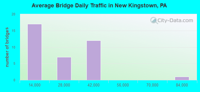
- 742,742Total average daily traffic
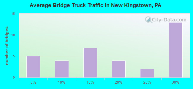
- 162,273Total average daily truck traffic
- National Bridge Inventory (NBI) Registered Bridges for New Kingstown
- No street view available for this location
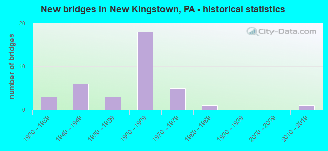
- New bridges - historical statistics
- 31930-1939
- 61940-1949
- 31950-1959
- 181960-1969
- 51970-1979
- 11980-1989
- 12010-2019
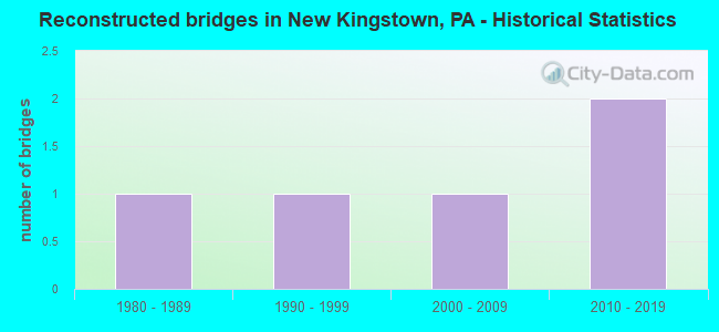
- Reconstructed bridges - Historical Statistics
- 11980-1989
- 11990-1999
- 12000-2009
- 22010-2019
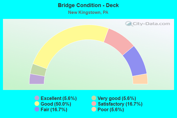
- Bridge Condition - Deck
- 5.6%Excellent
- 5.6%Very good
- 50.0%Good
- 16.7%Satisfactory
- 16.7%Fair
- 5.6%Poor
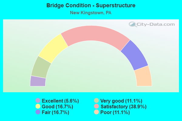
- Bridge Condition - Superstructure
- 5.6%Excellent
- 11.1%Very good
- 16.7%Good
- 38.9%Satisfactory
- 16.7%Fair
- 11.1%Poor
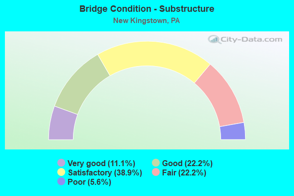
- Bridge Condition - Substructure
- 11.1%Very good
- 22.2%Good
- 38.9%Satisfactory
- 22.2%Fair
- 5.6%Poor
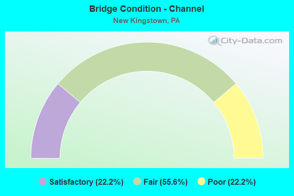
- Bridge Condition - Channel
- 22.2%Satisfactory
- 55.6%Fair
- 22.2%Poor
Find on map >> Show street view
Structure Number: 13571, Location: HOGESTOWN (Lat: 40.245794, Lng: -77.032369), Route carried "on" structure: US 11, Year Built: 1936, Status: Open, Structure Length: 1.04m (3.41ft), Average Daily Traffic: 10,415 (year 2021), Truck Traffic: 11%, Average Future Daily Traffic: 16,233 (year 2032), Design Load: H 20, Features Intersected: HOGESTOWN RUN
Minimum Vertical Clearance: 30+ m (98+ ft), Kilometerpoint: 49.185, Lanes on structure: 2, Base Highway Network: Yes, Owner: State Highway Agency, Approaching Roadway Width: 12.8m (42.0ft), Material/Design: Concrete, Design/Construction: Tee Beam, Number Of Spans In Main Unit: 1, Length of Maximum Span: 9.1m (29.9ft), Curb or Sidewalk Widths: Left: 0.2m (0.7ft), Right: 0.2m (0.7ft), Curb-To-Curb Width: 14.3m (46.9ft), Out-to-Out Width: 15.6m (51.2ft)
Condition: Deck: Satisfactory, Superstructure: Satisfactory, Substructure: Satisfactory, Channel: Poor, Operating Rating: 49.0 metric tons, Method Used To Determine Operating Rating: Load Factor (LF), Inventory Rating: 29.0 metric tons, Method Used To Determine Inventory Rating: Load Factor (LF), Structural Evaluation: Equal to present minimum criteria, Deck Geometry: Superior to present desirable criteria, Waterway Adequacy: Equal to present minimum criteria, Approach Roadway Alignment: Equal to present desirable criteria, Length Of Structure Improvement: 1.60m (5.25ft), Designated Inspection Frequency: Every 24 months, Inspection Date: May 2020, Bridge Improvement Cost: $6,000, Roadway Improvement Cost: $18,000, Total Project Cost: $81,000, Deck Structure Type: Concrete Cast-file-Place, Wearing Surface/Protective System: Wearing Surface: Monolithic Concrete
Find on map >> Show street view
Structure Number: 13572, Location: HOGESTOWN (Lat: 40.245300, Lng: -77.032411), Route carried "on" structure: US 11, Year Built: 1941, Status: Open, Structure Length: 1.19m (3.90ft), Average Daily Traffic: 9,990 (year 2021), Truck Traffic: 12%, Average Future Daily Traffic: 12,061 (year 2032), Design Load: HS 20, Features Intersected: HOGESTOWN RUN
Minimum Vertical Clearance: 30+ m (98+ ft), Kilometerpoint: 49.170, Lanes on structure: 2, Base Highway Network: Yes, Owner: State Highway Agency, Approaching Roadway Width: 11.6m (38.1ft), Skew: 3 degrees, Material/Design: Concrete, Design/Construction: Tee Beam, Number Of Spans In Main Unit: 1, Length of Maximum Span: 11.6m (38.1ft), Curb or Sidewalk Widths: Left: 0.2m (0.7ft), Right: 0.2m (0.7ft), Curb-To-Curb Width: 11.4m (37.4ft), Out-to-Out Width: 12.4m (40.7ft)
Condition: Deck: Fair, Superstructure: Satisfactory, Substructure: Satisfactory, Channel: Poor, Operating Rating: 59.0 metric tons, Method Used To Determine Operating Rating: Load Factor (LF), Inventory Rating: 35.4 metric tons, Method Used To Determine Inventory Rating: Load Factor (LF), Structural Evaluation: Equal to present minimum criteria, Deck Geometry: Equal to present minimum criteria, Waterway Adequacy: Equal to present minimum criteria, Approach Roadway Alignment: Equal to present desirable criteria, Length Of Structure Improvement: 1.80m (5.91ft), Designated Inspection Frequency: Every 24 months, Inspection Date: May 2020, Bridge Improvement Cost: $5,000, Roadway Improvement Cost: $16,000, Total Project Cost: $72,000, Deck Structure Type: Concrete Cast-file-Place, Wearing Surface/Protective System: Wearing Surface: Monolithic Concrete
Find on map >> Show street view
Structure Number: 13695, Location: I-81 NB OVER US 11 (Lat: 40.234450, Lng: -77.127631), Route carried "on" structure: Interstate 81, Year Built: 1963, Year Reconstructed: 1995, Status: Open, Structure Length: 5.46m (17.91ft), Average Daily Traffic: 36,531 (year 2021), Truck Traffic: 28%, Average Future Daily Traffic: 44,966 (year 2032), Design Load: HS 25 or greater, Features Intersected: US 11; SR 0011
Minimum Vertical Clearance: 30+ m (98+ ft), Kilometerpoint: 41.471, Lanes on structure: 3, Lanes under structure: 10, Base Highway Network: Yes, Owner: State Highway Agency, Approaching Roadway Width: 14.0m (45.9ft), Skew: 13 degrees, Material/Design: Steel, Design/Construction: Stringer/Multi-beam, Number Of Spans In Main Unit: 1, Number Of Approach Spans: 2, Length of Maximum Span: 27.4m (89.9ft), Curb or Sidewalk Widths: Left: 0.2m (0.7ft), Right: 0.2m (0.7ft), Curb-To-Curb Width: 15.2m (49.9ft), Out-to-Out Width: 16.3m (53.5ft)
Condition: Deck: Good, Superstructure: Satisfactory, Substructure: Fair, Operating Rating: 66.2 metric tons, Method Used To Determine Operating Rating: Load Factor (LF), Inventory Rating: 36.3 metric tons, Method Used To Determine Inventory Rating: Load Factor (LF), Structural Evaluation: Somewhat better than minimum adequacy, Deck Geometry: Meets minimum limits, Underclear: Superior to present desirable criteria, Approach Roadway Alignment: Equal to present desirable criteria, Length Of Structure Improvement: 6.10m (20.01ft), Designated Inspection Frequency: Every 24 months, Inspection Date: April 2020, Deck Structure Type: Concrete Cast-file-Place, Wearing Surface/Protective System: Wearing Surface: Monolithic Concrete, Deck Protection: Epoxy Coated Reinforcing
Find on map >> Show street view
Structure Number: 13697, Location: I-81 SB OVER US 11 (Lat: 40.234417, Lng: -77.128044), Route carried "on" structure: Interstate 81, Year Built: 1963, Year Reconstructed: 1994, Status: Open, Structure Length: 5.30m (17.39ft), Average Daily Traffic: 36,923 (year 2021), Truck Traffic: 26%, Average Future Daily Traffic: 44,755 (year 2032), Design Load: HS 25 or greater, Features Intersected: US 11; SR 0011
Minimum Vertical Clearance: 30+ m (98+ ft), Kilometerpoint: 41.450, Lanes on structure: 3, Lanes under structure: 8, Base Highway Network: Yes, Owner: State Highway Agency, Approaching Roadway Width: 14.0m (45.9ft), Skew: 13 degrees, Material/Design: Steel, Design/Construction: Stringer/Multi-beam, Number Of Spans In Main Unit: 1, Number Of Approach Spans: 2, Length of Maximum Span: 27.7m (90.9ft), Curb or Sidewalk Widths: Left: 0.2m (0.7ft), Right: 0.2m (0.7ft), Curb-To-Curb Width: 15.2m (49.9ft), Out-to-Out Width: 16.3m (53.5ft)
Condition: Deck: Good, Superstructure: Satisfactory, Substructure: Fair, Operating Rating: 67.1 metric tons, Method Used To Determine Operating Rating: Load Factor (LF), Inventory Rating: 36.3 metric tons, Method Used To Determine Inventory Rating: Load Factor (LF), Structural Evaluation: Somewhat better than minimum adequacy, Deck Geometry: Meets minimum limits, Underclear: Superior to present desirable criteria, Approach Roadway Alignment: Equal to present desirable criteria, Length Of Structure Improvement: 6.10m (20.01ft), Designated Inspection Frequency: Every 24 months, Inspection Date: April 2020, Deck Structure Type: Concrete Cast-file-Place, Wearing Surface/Protective System: Wearing Surface: Monolithic Concrete, Deck Protection: Epoxy Coated Reinforcing
Find on map >> Show street view
Structure Number: 13698, Location: T-574 OVER I-81 (Lat: 40.242733, Lng: -77.100806), Route carried "on" structure: State highway , Year Built: 1969, Status: Open, Structure Length: 8.60m (28.22ft), Average Daily Traffic: 1,503 (year 2021), Truck Traffic: 3%, Average Future Daily Traffic: 2,332 (year 2032), Design Load: HS 20, Features Intersected: I-81; SR 0081, Facility Carried by Structure: T-574; BERNHEISEL
Minimum Vertical Clearance: 30+ m (98+ ft), Kilometerpoint: 0.000, Lanes on structure: 2, Lanes under structure: 8, Owner: State Highway Agency, Approaching Roadway Width: 7.3m (24.0ft), Skew: 1 degrees, Material/Design: Prestressed concrete, Design/Construction: Stringer/Multi-beam, Number Of Spans In Main Unit: 4, Length of Maximum Span: 29.9m (98.1ft), Curb or Sidewalk Widths: Left: 0.2m (0.7ft), Right: 0.2m (0.7ft), Curb-To-Curb Width: 12.8m (42.0ft), Out-to-Out Width: 14.0m (45.9ft)
Condition: Deck: Very good, Superstructure: Satisfactory, Substructure: Good, Operating Rating: 73.5 metric tons, Method Used To Determine Operating Rating: Load Factor (LF), Inventory Rating: 23.6 metric tons, Method Used To Determine Inventory Rating: Load Factor (LF), Structural Evaluation: Equal to present minimum criteria, Deck Geometry: Better than present minimum criteria, Underclear: Somewhat better than minimum adequacy, Approach Roadway Alignment: Better than present minimum criteria, Length Of Structure Improvement: 9.60m (31.50ft), Designated Inspection Frequency: Every 24 months, Inspection Date: April 2020, Deck Structure Type: Concrete Cast-file-Place, Wearing Surface/Protective System: Wearing Surface: Latex Concrete
Find on map >> Show street view
Structure Number: 13703, Location: 0.8 MI.E. OF L.R. 21001 (Lat: 40.271625, Lng: -77.033072), Route carried "on" structure: Interstate 81, Year Built: 1973, Status: Open, Structure Length: 0.67m (2.20ft), Average Daily Traffic: 79,898 (year 2021), Truck Traffic: 19%, Average Future Daily Traffic: 100,406 (year 2032), Design Load: HS 20, Features Intersected: SIMMONS RUN
Minimum Vertical Clearance: 30+ m (98+ ft), Kilometerpoint: 50.229, Lanes on structure: 4, Base Highway Network: Yes, Owner: State Highway Agency, Approaching Roadway Width: 50.9m (167.0ft), Skew: 20 degrees, Material/Design: Concrete, Design/Construction: Culvert, Number Of Spans In Main Unit: 1, Length of Maximum Span: 6.7m (22.0ft)
Condition: Channel: Satisfactory, Culverts: Satisfactory, Operating Rating: 63.5 metric tons, Method Used To Determine Operating Rating: Field evaluation and documented engineering judgment, Inventory Rating: 42.6 metric tons, Method Used To Determine Inventory Rating: Field evaluation and documented engineering judgment, Structural Evaluation: Equal to present minimum criteria, Waterway Adequacy: Superior to present desirable criteria, Approach Roadway Alignment: Equal to present desirable criteria, Length Of Structure Improvement: 1.30m (4.27ft), Designated Inspection Frequency: Every 24 months, Inspection Date: May 2020
Find on map >> Show street view
Structure Number: 13704, Location: 1 MI.E. OF SR 0114 (Lat: 40.272083, Lng: -77.024747), Route carried "on" structure: State highway , Year Built: 1973, Status: Open, Structure Length: 8.81m (28.90ft), Average Daily Traffic: 1,354 (year 2021), Truck Traffic: 3%, Average Future Daily Traffic: 1,618 (year 2032), Design Load: HS 20, Features Intersected: I-81; SR 0081, Facility Carried by Structure: T-596 SAMPLE BR RD
Minimum Vertical Clearance: 30+ m (98+ ft), Kilometerpoint: 0.000, Lanes on structure: 2, Lanes under structure: 8, Owner: State Highway Agency, Approaching Roadway Width: 12.2m (40.0ft), Material/Design: Steel continuous, Design/Construction: Frame, Number Of Spans In Main Unit: 5, Length of Maximum Span: 27.4m (89.9ft), Curb or Sidewalk Widths: Left: 0.2m (0.7ft), Right: 0.2m (0.7ft), Curb-To-Curb Width: 12.8m (42.0ft), Out-to-Out Width: 14.0m (45.9ft)
Condition: Deck: Good, Superstructure: Good, Substructure: Fair, Operating Rating: 66.2 metric tons, Method Used To Determine Operating Rating: Allowable Stress (AS), Inventory Rating: 38.1 metric tons, Method Used To Determine Inventory Rating: Allowable Stress (AS), Structural Evaluation: Somewhat better than minimum adequacy, Deck Geometry: Better than present minimum criteria, Underclear: Somewhat better than minimum adequacy, Approach Roadway Alignment: Equal to present desirable criteria, Length Of Structure Improvement: 9.80m (32.15ft), Designated Inspection Frequency: Every 24 months, Inspection Date: April 2020, Deck Structure Type: Concrete Cast-file-Place, Wearing Surface/Protective System: Wearing Surface: Latex Concrete
Find on map >> Show street view
Structure Number: 1372, Location: WERTZVILLE (Lat: 40.268847, Lng: -77.044008), Route carried "on" structure: State highway 114, Year Built: 1969, Status: Open, Structure Length: 8.99m (29.49ft), Average Daily Traffic: 22,373 (year 2022), Truck Traffic: 5%, Average Future Daily Traffic: 25,611 (year 2032), Design Load: HS 20, Features Intersected: 81
Minimum Vertical Clearance: 30+ m (98+ ft), Kilometerpoint: 1.651, Lanes on structure: 4, Lanes under structure: 8, Owner: State Highway Agency, Approaching Roadway Width: 26.8m (87.9ft), Skew: 21 degrees, Material/Design: Prestressed concrete, Design/Construction: Stringer/Multi-beam, Number Of Spans In Main Unit: 4, Length of Maximum Span: 30.5m (100.1ft), Curb or Sidewalk Widths: Left: 0.2m (0.7ft), Right: 0.2m (0.7ft), Curb-To-Curb Width: 27.1m (88.9ft), Out-to-Out Width: 28.0m (91.9ft)
Condition: Deck: Satisfactory, Superstructure: Satisfactory, Substructure: Satisfactory, Operating Rating: 70.8 metric tons, Method Used To Determine Operating Rating: Load Factor (LF), Inventory Rating: 20.0 metric tons, Method Used To Determine Inventory Rating: Load Factor (LF), Structural Evaluation: Somewhat better than minimum adequacy, Deck Geometry: Superior to present desirable criteria, Underclear: Somewhat better than minimum adequacy, Approach Roadway Alignment: Equal to present desirable criteria, Length Of Structure Improvement: 10.10m (33.14ft), Designated Inspection Frequency: Every 24 months, Inspection Date: May 2020, Bridge Improvement Cost: $417,000, Roadway Improvement Cost: $1,228,000, Total Project Cost: $5,628,000, Deck Structure Type: Concrete Cast-file-Place, Wearing Surface/Protective System: Wearing Surface: Latex Concrete
Find on map >> Show street view
Structure Number: 13721, Location: HOGESTOWN (Lat: 40.254022, Lng: -77.031533), Route carried "on" structure: State highway 114, Year Built: 1974, Status: Open, Structure Length: 11.67m (38.29ft), Average Daily Traffic: 22,373 (year 2022), Truck Traffic: 5%, Average Future Daily Traffic: 25,611 (year 2032), Design Load: HS 20, Features Intersected: CONODOGUINET CREEK
Minimum Vertical Clearance: 30+ m (98+ ft), Kilometerpoint: 3.050, Lanes on structure: 4, Owner: State Highway Agency, Approaching Roadway Width: 26.8m (87.9ft), Skew: 32 degrees, Material/Design: Prestressed concrete, Design/Construction: Stringer/Multi-beam, Number Of Spans In Main Unit: 4, Length of Maximum Span: 28.3m (92.8ft), Curb or Sidewalk Widths: Left: 0.2m (0.7ft), Right: 0.2m (0.7ft), Curb-To-Curb Width: 26.8m (87.9ft), Out-to-Out Width: 28.0m (91.9ft)
Condition: Deck: Satisfactory, Superstructure: Fair, Substructure: Fair, Channel: Satisfactory, Inventory Rating: 25.4 metric tons, Method Used To Determine Inventory Rating: Load Factor (LF), Structural Evaluation: Somewhat better than minimum adequacy, Deck Geometry: Superior to present desirable criteria, Waterway Adequacy: Better than present minimum criteria, Approach Roadway Alignment: Equal to present desirable criteria, Length Of Structure Improvement: 12.80m (41.99ft), Designated Inspection Frequency: Every 24 months, Inspection Date: May 2020, Bridge Improvement Cost: $414,000, Roadway Improvement Cost: $1,218,000, Total Project Cost: $5,584,000, Deck Structure Type: Concrete Cast-file-Place, Wearing Surface/Protective System: Wearing Surface: Monolithic Concrete
Find on map >> Show street view
Structure Number: 13839, Location: 1.3 MI.E. OF SR 1007 (Lat: 40.254758, Lng: -77.069100), Route carried "on" structure: State highway , Year Built: 1969, Status: Open, Structure Length: 9.94m (32.61ft), Average Daily Traffic: 2,482 (year 2021), Truck Traffic: 3%, Average Future Daily Traffic: 2,789 (year 2032), Design Load: HS 20, Features Intersected: I-81; SR 0081, Facility Carried by Structure: SR 1009
Minimum Vertical Clearance: 30+ m (98+ ft), Kilometerpoint: 1.653, Lanes on structure: 2, Lanes under structure: 4, Owner: State Highway Agency, Approaching Roadway Width: 9.1m (29.9ft), Skew: 3 degrees, Material/Design: Prestressed concrete, Design/Construction: Stringer/Multi-beam, Number Of Spans In Main Unit: 4, Length of Maximum Span: 32.6m (107.0ft), Curb or Sidewalk Widths: Left: 0.2m (0.7ft), Right: 0.2m (0.7ft), Curb-To-Curb Width: 12.8m (42.0ft), Out-to-Out Width: 14.0m (45.9ft)
Condition: Deck: Good, Superstructure: Fair, Substructure: Good, Operating Rating: 84.4 metric tons, Method Used To Determine Operating Rating: Load Factor (LF), Inventory Rating: 22.7 metric tons, Method Used To Determine Inventory Rating: Load Factor (LF), Structural Evaluation: Somewhat better than minimum adequacy, Deck Geometry: Equal to present minimum criteria, Underclear: Somewhat better than minimum adequacy, Approach Roadway Alignment: Equal to present desirable criteria, Length Of Structure Improvement: 10.90m (35.76ft), Designated Inspection Frequency: Every 24 months, Inspection Date: April 2020, Bridge Improvement Cost: $79,000, Roadway Improvement Cost: $233,000, Total Project Cost: $1,068,000, Deck Structure Type: Concrete Cast-file-Place, Wearing Surface/Protective System: Wearing Surface: Latex Concrete
Find on map >> Show street view
Structure Number: 13841, Location: JUST NORTH OF SR1012 (Lat: 40.258492, Lng: -77.077411), Route carried "on" structure: State highway , Year Built: 1964, Year Reconstructed: 2009, Status: Open, Structure Length: 10.67m (35.01ft), Average Daily Traffic: 1,029 (year 2020), Truck Traffic: 2%, Average Future Daily Traffic: 1,204 (year 2032), Design Load: HS 20, Features Intersected: CONODOGUINET CREEK, Facility Carried by Structure: SR 1009 RICH VAL.R
Minimum Vertical Clearance: 30+ m (98+ ft), Kilometerpoint: 3.067, Lanes on structure: 2, Owner: State Highway Agency, Approaching Roadway Width: 8.5m (27.9ft), Skew: 2 degrees, Material/Design: Steel, Design/Construction: Stringer/Multi-beam, Number Of Spans In Main Unit: 4, Length of Maximum Span: 25.6m (84.0ft), Curb or Sidewalk Widths: Left: 0.5m (1.6ft), Right: 0.5m (1.6ft), Curb-To-Curb Width: 8.5m (27.9ft), Out-to-Out Width: 10.2m (33.5ft)
Condition: Deck: Good, Superstructure: Fair, Substructure: Satisfactory, Channel: Fair, Operating Rating: 92.5 metric tons, Method Used To Determine Operating Rating: Load Factor (LF), Inventory Rating: 55.3 metric tons, Method Used To Determine Inventory Rating: Load Factor (LF), Structural Evaluation: Somewhat better than minimum adequacy, Deck Geometry: Somewhat better than minimum adequacy, Waterway Adequacy: Superior to present desirable criteria, Approach Roadway Alignment: Equal to present desirable criteria, Length Of Structure Improvement: 11.70m (38.39ft), Designated Inspection Frequency: Every 24 months, Inspection Date: April 2020, Deck Structure Type: Concrete Cast-file-Place, Wearing Surface/Protective System: Wearing Surface: Latex Concrete
Find on map >> Show street view
Structure Number: 1402, Location: SILVER SPRING TWP (Lat: 40.216875, Lng: -77.088089), Route carried "on" structure: City street 571, Year Built: 1949, Status: Open, Structure Length: 2.65m (8.69ft), Average Daily Traffic: 200 (year 1992), Truck Traffic: 10%, Average Future Daily Traffic: 315 (year 2030), Design Load: HS 20, Features Intersected: PA TPK (I-76)
Minimum Vertical Clearance: 4.57m (14.99ft), Kilometerpoint: 0.000, Lanes on structure: 2, Lanes under structure: 4, Owner: State Toll Authority, Approaching Roadway Width: 7.9m (25.9ft), Material/Design: Concrete, Design/Construction: Frame, Number Of Spans In Main Unit: 1, Length of Maximum Span: 23.8m (78.1ft), Curb or Sidewalk Widths: Left: 0.3m (1.0ft), Right: 0.3m (1.0ft), Curb-To-Curb Width: 6.7m (22.0ft), Out-to-Out Width: 7.7m (25.3ft)
Condition: Deck: Good, Superstructure: Good, Substructure: Good, Operating Rating: 47.2 metric tons, Method Used To Determine Operating Rating: Field evaluation and documented engineering judgment, Inventory Rating: 28.1 metric tons, Method Used To Determine Inventory Rating: Field evaluation and documented engineering judgment, Structural Evaluation: Better than present minimum criteria, Deck Geometry: Meets minimum limits, Underclear: Meets minimum limits, Approach Roadway Alignment: Equal to present desirable criteria, Length Of Structure Improvement: 3.40m (11.15ft), Designated Inspection Frequency: Every 24 months, Inspection Date: Febuary 2021, Bridge Improvement Cost: $6,000, Roadway Improvement Cost: $18,000, Total Project Cost: $82,000, Wearing Surface/Protective System: Wearing Surface: Bituminous
Find on map >> Show street view
Structure Number: 14023, Location: SILVER SPRING TWP (Lat: 40.211131, Lng: -77.068267), Route carried "on" structure: Interstate 76, Year Built: 1949, Status: Open, Structure Length: 1.13m (3.71ft), Average Daily Traffic: 20,357 (year 2001), Truck Traffic: 29%, Average Future Daily Traffic: 23,799 (year 2030), Design Load: HS 20, Features Intersected: LR21012, SR1007
Minimum Vertical Clearance: 30+ m (98+ ft), Kilometerpoint: 0.000, Lanes on structure: 4, Lanes under structure: 2, Base Highway Network: Yes, Toll: On toll road, Owner: State Toll Authority, Approaching Roadway Width: 23.5m (77.1ft), Skew: 31 degrees, Material/Design: Concrete, Design/Construction: Tee Beam, Number Of Spans In Main Unit: 1, Length of Maximum Span: 9.4m (30.8ft), Curb or Sidewalk Widths: Left: 0.2m (0.7ft), Right: 0.2m (0.7ft), Curb-To-Curb Width: 20.6m (67.6ft), Out-to-Out Width: 22.7m (74.5ft)
Condition: Deck: Fair, Superstructure: Satisfactory, Substructure: Satisfactory, Operating Rating: 59.9 metric tons, Method Used To Determine Operating Rating: Load Factor (LF), Inventory Rating: 35.4 metric tons, Method Used To Determine Inventory Rating: Load Factor (LF), Structural Evaluation: Equal to present minimum criteria, Deck Geometry: Equal to present minimum criteria, Underclear: High priority of corrective action, Approach Roadway Alignment: Equal to present desirable criteria, Length Of Structure Improvement: 1.70m (5.58ft), Designated Inspection Frequency: Every 24 months, Inspection Date: Febuary 2021, Deck Structure Type: Concrete Cast-file-Place, Wearing Surface/Protective System: Wearing Surface: Latex Concrete
Find on map >> Show street view
Structure Number: 14079, Location: 6.4 NE CARLISLE MIDDLESEX (Lat: 40.259800, Lng: -77.102914), Route carried "on" structure: City street , Year Built: 1959, Year Reconstructed: 2016, Status: Open, Structure Length: 8.05m (26.41ft), Average Daily Traffic: 2,000 (year 2021), Truck Traffic: 16%, Average Future Daily Traffic: 2,500 (year 2041), Design Load: H 20, Features Intersected: CONODOGUINET CREEK, Facility Carried by Structure: BERNHEISEL ROAD
Minimum Vertical Clearance: 30+ m (98+ ft), Kilometerpoint: 0.000, Lanes on structure: 2, Owner: County Highway Agency, Approaching Roadway Width: 6.1m (20.0ft), Skew: 2 degrees, Material/Design: Prestressed concrete continuous, Design/Construction: Box Beam or Girders - Multiple, Number Of Spans In Main Unit: 4, Length of Maximum Span: 20.1m (65.9ft), Curb or Sidewalk Widths: Left: 1.5m (4.9ft), Right: 0.3m (1.0ft), Curb-To-Curb Width: 6.6m (21.7ft), Out-to-Out Width: 7.3m (24.0ft)
Condition: Deck: Good, Superstructure: Very good, Substructure: Satisfactory, Channel: Fair, Operating Rating: 66.2 metric tons, Method Used To Determine Operating Rating: Load Factor (LF), Inventory Rating: 49.0 metric tons, Method Used To Determine Inventory Rating: Load Factor (LF), Structural Evaluation: Equal to present minimum criteria, Deck Geometry: High priority of replacement, Waterway Adequacy: Superior to present desirable criteria, Approach Roadway Alignment: Equal to present desirable criteria, Length Of Structure Improvement: 9.00m (29.53ft), Designated Inspection Frequency: Every 24 months, Inspection Date: September 2021, Bridge Improvement Cost: $16,000, Roadway Improvement Cost: $46,000, Total Project Cost: $211,000, Wearing Surface/Protective System: Wearing Surface: Monolithic Concrete
Find on map >> Show street view
Structure Number: 14089, Location: 2.4 NW MCHNICBRG/HOGESTOW (Lat: 40.227150, Lng: -77.054631), Route carried "on" structure: City street , Year Built: 1952, Status: Posted for load, Structure Length: 1.28m (4.20ft), Average Daily Traffic: 2,000 (year 2019), Truck Traffic: 5%, Average Future Daily Traffic: 2,500 (year 2039), Design Load: HS 20, Features Intersected: HOGESTOWN RUN, Facility Carried by Structure: HEMPT ROAD (T-573)
Minimum Vertical Clearance: 30+ m (98+ ft), Kilometerpoint: 0.000, Lanes on structure: 2, Owner: Town or Township Highway Agency, Approaching Roadway Width: 6.4m (21.0ft), Skew: 4 degrees, Material/Design: Prestressed concrete, Design/Construction: Box Beam or Girders - Multiple, Number Of Spans In Main Unit: 2, Length of Maximum Span: 5.5m (18.0ft), Curb-To-Curb Width: 6.9m (22.6ft), Out-to-Out Width: 7.4m (24.3ft)
Condition: Deck: Poor, Superstructure: Poor, Substructure: Poor, Channel: Fair, Operating Rating: 18.1 metric tons, Method Used To Determine Operating Rating: Load Factor (LF), Inventory Rating: 14.5 metric tons, Method Used To Determine Inventory Rating: Load Factor (LF), Structural Evaluation: Meets minimum limits, Deck Geometry: High priority of corrective action, Waterway Adequacy: Equal to present minimum criteria, Approach Roadway Alignment: Equal to present desirable criteria, Bridge Posting: Required (Relationship of Operating Rating to Maximum Legal Load: > 39.9% below), Length Of Structure Improvement: 1.90m (6.23ft), Designated Inspection Frequency: Every 24 months, Other Special Inspection Frequency: Every 6 months, Inspection Date: August 2021, Other Special Inspection Date: August 2021, Bridge Improvement Cost: $3,000, Roadway Improvement Cost: $10,000, Total Project Cost: $45,000, Deck Structure Type: Other, Wearing Surface/Protective System: Wearing Surface: Bituminous
Find on map >> Show street view
Structure Number: 1409, Location: 1.4SE 76/81 CONRAIL (Lat: 40.227031, Lng: -77.103217), Route carried "on" structure: City street , Year Built: 1989, Status: Open, Structure Length: 1.28m (4.20ft), Average Daily Traffic: 200 (year 2021), Average Future Daily Traffic: 280 (year 2041), Design Load: HS 20, Features Intersected: NORFOLK SOUTHERN RAILRD., Facility Carried by Structure: APPALACHIAN DRIVE
Minimum Vertical Clearance: 30+ m (98+ ft), Kilometerpoint: 0.000, Lanes on structure: 2, Owner: Town or Township Highway Agency, Approaching Roadway Width: 9.1m (29.9ft), Material/Design: Prestressed concrete, Design/Construction: Box Beam or Girders - Single/Spread, Number Of Spans In Main Unit: 1, Length of Maximum Span: 12.2m (40.0ft), Curb or Sidewalk Widths: Left: 0.2m (0.7ft), Right: 0.2m (0.7ft), Curb-To-Curb Width: 8.5m (27.9ft), Out-to-Out Width: 9.3m (30.5ft)
Condition: Deck: Good, Superstructure: Good, Substructure: Good, Operating Rating: 37.2 metric tons, Method Used To Determine Operating Rating: Load Factor (LF), Inventory Rating: 22.7 metric tons, Method Used To Determine Inventory Rating: Load Factor (LF), Structural Evaluation: Equal to present minimum criteria, Deck Geometry: Equal to present minimum criteria, Underclear: High priority of corrective action, Approach Roadway Alignment: Equal to present minimum criteria, Length Of Structure Improvement: 1.90m (6.23ft), Designated Inspection Frequency: Every 24 months, Inspection Date: August 2021, Deck Structure Type: Concrete Cast-file-Place, Wearing Surface/Protective System: Wearing Surface: Monolithic Concrete, Deck Protection: Epoxy Coated Reinforcing
Find on map >> Show street view
Structure Number: 14091, Location: 2.7E KINGSTON/HOGESTOWN (Lat: 40.244853, Lng: -77.032950), Route carried "on" structure: City street , Year Built: 1930, Status: Posted for load, Structure Length: 1.10m (3.61ft), Average Daily Traffic: 450 (year 2018), Average Future Daily Traffic: 630 (year 2038), Features Intersected: OVER HOGESTOWN RUN, Facility Carried by Structure: VILLAGE RD.(T-582)
Minimum Vertical Clearance: 30+ m (98+ ft), Kilometerpoint: 0.000, Lanes on structure: 2, Owner: Town or Township Highway Agency, Approaching Roadway Width: 6.4m (21.0ft), Material/Design: Concrete, Design/Construction: Tee Beam, Number Of Spans In Main Unit: 1, Length of Maximum Span: 10.4m (34.1ft), Curb or Sidewalk Widths: Left: 0.3m (1.0ft), Right: 0.3m (1.0ft), Curb-To-Curb Width: 7.4m (24.3ft), Out-to-Out Width: 8.4m (27.6ft)
Condition: Deck: Fair, Superstructure: Poor, Substructure: Satisfactory, Channel: Fair, Operating Rating: 74.4 metric tons, Method Used To Determine Operating Rating: Field evaluation and documented engineering judgment, Inventory Rating: 42.6 metric tons, Method Used To Determine Inventory Rating: Field evaluation and documented engineering judgment, Structural Evaluation: Meets minimum limits, Deck Geometry: Meets minimum limits, Waterway Adequacy: Superior to present desirable criteria, Approach Roadway Alignment: Equal to present desirable criteria, Bridge Posting: Required (Relationship of Operating Rating to Maximum Legal Load: 10.0 - 19.9% below), Length Of Structure Improvement: 1.70m (5.58ft), Designated Inspection Frequency: Every 24 months, Other Special Inspection Frequency: Every 12 months, Inspection Date: August 2021, Other Special Inspection Date: August 2021, Bridge Improvement Cost: $3,000, Roadway Improvement Cost: $10,000, Total Project Cost: $45,000, Deck Structure Type: Concrete Cast-file-Place, Wearing Surface/Protective System: Wearing Surface: Bituminous
Find on map >> Show street view
Structure Number: 14093, Location: 4.2 NW HOGSTWN/BRENIZER (Lat: 40.264292, Lng: -77.072778), Route carried "on" structure: City street , Year Built: 1930, Year Reconstructed: 2018, Status: Open, Structure Length: 0.79m (2.59ft), Average Daily Traffic: 800 (year 2021), Truck Traffic: 1%, Average Future Daily Traffic: 1,000 (year 2041), Design Load: HL 93, Features Intersected: BRENIZER RUN, Facility Carried by Structure: BEECHCLIFF DR.T606
Minimum Vertical Clearance: 30+ m (98+ ft), Kilometerpoint: 0.000, Lanes on structure: 2, Owner: Town or Township Highway Agency, Approaching Roadway Width: 4.9m (16.1ft), Skew: 4 degrees, Material/Design: Steel, Design/Construction: Stringer/Multi-beam, Number Of Spans In Main Unit: 1, Length of Maximum Span: 7.6m (24.9ft), Curb-To-Curb Width: 6.7m (22.0ft), Out-to-Out Width: 7.6m (24.9ft)
Condition: Deck: Excellent, Superstructure: Excellent, Substructure: Very good, Channel: Fair, Operating Rating: 73.5 metric tons, Method Used To Determine Operating Rating: Load and Resistance Factor (LRFR), Inventory Rating: 57.2 metric tons, Method Used To Determine Inventory Rating: Load and Resistance Factor (LRFR), Structural Evaluation: Equal to present desirable criteria, Deck Geometry: Meets minimum limits, Waterway Adequacy: Better than present minimum criteria, Approach Roadway Alignment: Equal to present minimum criteria, Length Of Structure Improvement: 0.80m (2.62ft), Designated Inspection Frequency: Every 24 months, Inspection Date: August 2021, Bridge Improvement Cost: $9,000, Roadway Improvement Cost: $25,000, Total Project Cost: $117,000, Deck Structure Type: Concrete Cast-file-Place, Wearing Surface/Protective System: Wearing Surface: Monolithic Concrete, Deck Protection: Epoxy Coated Reinforcing
Find on map >> Show street view
Structure Number: 56189, Location: MIDDLESEX TWP (Lat: 40.224333, Lng: -77.114381), Route carried "on" structure: Interstate 76, Year Built: 2018, Status: Open, Structure Length: 7.47m (24.51ft), Average Daily Traffic: 20,357 (year 2001), Truck Traffic: 29%, Average Future Daily Traffic: 23,799 (year 2030), Design Load: HS 20, Features Intersected: Norfolk Southern RR
Minimum Vertical Clearance: 30+ m (98+ ft), Kilometerpoint: 0.000, Lanes on structure: 4, Base Highway Network: Yes, Toll: On toll road, Owner: State Toll Authority, Approaching Roadway Width: 37.2m (122.0ft), Skew: 35 degrees, Material/Design: Steel continuous, Design/Construction: Stringer/Multi-beam, Number Of Spans In Main Unit: 3, Length of Maximum Span: 30.5m (100.1ft), Curb or Sidewalk Widths: Left: 0.2m (0.7ft), Right: 0.2m (0.7ft), Curb-To-Curb Width: 18.1m (59.4ft), Out-to-Out Width: 38.2m (125.3ft)
Condition: Deck: Good, Superstructure: Very good, Substructure: Very good, Inventory Rating: 82.6 metric tons, Method Used To Determine Inventory Rating: Assigned ratings based on Load and Resistance Factor Design (LRFD) reported in metric tons, Structural Evaluation: Equal to present desirable criteria, Deck Geometry: Meets minimum limits, Underclear: High priority of corrective action, Approach Roadway Alignment: Equal to present desirable criteria, Designated Inspection Frequency: Every 24 months, Inspection Date: Febuary 2021, Deck Structure Type: Concrete Cast-file-Place, Wearing Surface/Protective System: Wearing Surface: Monolithic Concrete, Deck Protection: Epoxy Coated Reinforcing
Find on map >> Show street view
Structure Number: 13695, Location: I-81 NB OVER US 11 (Lat: 40.234450, Lng: -77.127631), Route carried "under" structure: US 11, Year Built: 1963, Structure Length: 0. m, Average Daily Traffic: 6,399 (year 2022), Truck Traffic: 12%, Features Intersected: US 11; SR 0011, Facility Carried by Structure: I-81 NB; SR 0081
Minimum Vertical Clearance: 5.13m (16.83ft), Kilometerpoint: 40.527, Lanes on structure: 3, Lanes under structure: 5, Material/Design: Steel, Design/Construction: Stringer/Multi-beam, Length of Maximum Span: 27.4m (89.9ft)
Find on map >> Show street view
Structure Number: 13695, Location: I-81 NB OVER US 11 (Lat: 40.234450, Lng: -77.127631), Route carried "under" structure: US 11, Year Built: 1963, Structure Length: 0. m, Average Daily Traffic: 6,523 (year 2022), Truck Traffic: 13%, Features Intersected: US 11; SR 0011, Facility Carried by Structure: I-81 NB; SR 0081
Minimum Vertical Clearance: 5.11m (16.77ft), Kilometerpoint: 40.514, Lanes on structure: 3, Lanes under structure: 5, Material/Design: Steel, Design/Construction: Stringer/Multi-beam, Length of Maximum Span: 27.4m (89.9ft)
Find on map >> Show street view
Structure Number: 13697, Location: I-81 SB OVER US 11 (Lat: 40.234417, Lng: -77.128044), Route carried "under" structure: US 11, Year Built: 1963, Structure Length: 0. m, Average Daily Traffic: 6,523 (year 2022), Truck Traffic: 13%, Features Intersected: US 11; SR 0011, Facility Carried by Structure: I-81 SB; SR 0081
Minimum Vertical Clearance: 5.39m (17.68ft), Kilometerpoint: 40.514, Lanes on structure: 3, Lanes under structure: 4, Material/Design: Steel, Design/Construction: Stringer/Multi-beam, Length of Maximum Span: 27.7m (90.9ft)
Find on map >> Show street view
Structure Number: 13697, Location: I-81 SB OVER US 11 (Lat: 40.234417, Lng: -77.128044), Route carried "under" structure: US 11, Year Built: 1963, Structure Length: 0. m, Average Daily Traffic: 6,399 (year 2022), Truck Traffic: 12%, Features Intersected: US 11; SR 0011, Facility Carried by Structure: I-81 SB; SR 0081
Minimum Vertical Clearance: 5.43m (17.81ft), Kilometerpoint: 40.527, Lanes on structure: 3, Lanes under structure: 4, Material/Design: Steel, Design/Construction: Stringer/Multi-beam, Length of Maximum Span: 27.7m (90.9ft)
Find on map >> Show street view
Structure Number: 13698, Location: T-574 OVER I-81 (Lat: 40.242733, Lng: -77.100806), Route carried "under" structure: Interstate 81, Year Built: 1969, Structure Length: 0. m, Average Daily Traffic: 36,531 (year 2021), Truck Traffic: 28%, Features Intersected: I-81; SR 0081, Facility Carried by Structure: T-574; BERNHEISEL
Minimum Vertical Clearance: 5.08m (16.67ft), Kilometerpoint: 43.797, Lanes on structure: 2, Lanes under structure: 4, Material/Design: Prestressed concrete, Design/Construction: Stringer/Multi-beam, Length of Maximum Span: 29.9m (98.1ft)
Find on map >> Show street view
Structure Number: 13698, Location: T-574 OVER I-81 (Lat: 40.242733, Lng: -77.100806), Route carried "under" structure: Interstate 81, Year Built: 1969, Structure Length: 0. m, Average Daily Traffic: 36,923 (year 2021), Truck Traffic: 26%, Features Intersected: I-81; SR 0081, Facility Carried by Structure: T-574; BERNHEISEL
Minimum Vertical Clearance: 4.90m (16.08ft), Kilometerpoint: 43.813, Lanes on structure: 2, Lanes under structure: 4, Material/Design: Prestressed concrete, Design/Construction: Stringer/Multi-beam, Length of Maximum Span: 29.9m (98.1ft)
Find on map >> Show street view
Structure Number: 13704, Location: 1 MI.E. OF SR 0114 (Lat: 40.272083, Lng: -77.024747), Route carried "under" structure: Interstate 81, Year Built: 1973, Structure Length: 0. m, Average Daily Traffic: 40,285 (year 2021), Truck Traffic: 16%, Features Intersected: I-81; SR 0081, Facility Carried by Structure: T-596 SAMPLE BR RD
Minimum Vertical Clearance: 5.49m (18.01ft), Kilometerpoint: 51.023, Lanes on structure: 2, Lanes under structure: 4, Material/Design: Steel continuous, Design/Construction: Frame, Length of Maximum Span: 27.4m (89.9ft)
Find on map >> Show street view
Structure Number: 13704, Location: 1 MI.E. OF SR 0114 (Lat: 40.272083, Lng: -77.024747), Route carried "under" structure: Interstate 81, Year Built: 1973, Structure Length: 0. m, Average Daily Traffic: 39,613 (year 2021), Truck Traffic: 21%, Features Intersected: I-81; SR 0081, Facility Carried by Structure: T-596 SAMPLE BR RD
Minimum Vertical Clearance: 5.23m (17.16ft), Kilometerpoint: 51.005, Lanes on structure: 2, Lanes under structure: 4, Material/Design: Steel continuous, Design/Construction: Frame, Length of Maximum Span: 27.4m (89.9ft)
Find on map >> Show street view
Structure Number: 1372, Location: WERTZVILLE (Lat: 40.268847, Lng: -77.044008), Route carried "under" structure: Interstate 81, Year Built: 1969, Structure Length: 0. m, Average Daily Traffic: 40,285 (year 2021), Truck Traffic: 16%, Features Intersected: 81, Facility Carried by Structure: 114 Willow Mill Rd
Minimum Vertical Clearance: 4.90m (16.08ft), Kilometerpoint: 49.407, Lanes on structure: 4, Lanes under structure: 4, Material/Design: Prestressed concrete, Design/Construction: Stringer/Multi-beam, Length of Maximum Span: 30.5m (100.1ft)
Find on map >> Show street view
Structure Number: 1372, Location: WERTZVILLE (Lat: 40.268847, Lng: -77.044008), Route carried "under" structure: Interstate 81, Year Built: 1969, Structure Length: 0. m, Average Daily Traffic: 39,613 (year 2021), Truck Traffic: 21%, Features Intersected: 81, Facility Carried by Structure: 114 Willow Mill Rd
Minimum Vertical Clearance: 5.49m (18.01ft), Kilometerpoint: 49.425, Lanes on structure: 4, Lanes under structure: 4, Material/Design: Prestressed concrete, Design/Construction: Stringer/Multi-beam, Length of Maximum Span: 30.5m (100.1ft)
Find on map >> Show street view
Structure Number: 13838, Location: 0.8 MI N OF TWP RD 874 (Lat: 40.244703, Lng: -77.087450), Route carried "under" structure: Interstate 81, Year Built: 1969, Structure Length: 0. m, Average Daily Traffic: 36,531 (year 2021), Truck Traffic: 28%, Features Intersected: I-81; SR 0081, Facility Carried by Structure: 1007 Locust Point
Minimum Vertical Clearance: 4.88m (16.01ft), Kilometerpoint: 45.390, Lanes on structure: 2, Lanes under structure: 4, Material/Design: Prestressed concrete, Design/Construction: Stringer/Multi-beam, Length of Maximum Span: 29.3m (96.1ft)
Find on map >> Show street view
Structure Number: 13838, Location: 0.8 MI N OF TWP RD 874 (Lat: 40.244703, Lng: -77.087450), Route carried "under" structure: Interstate 81, Year Built: 1969, Structure Length: 0. m, Average Daily Traffic: 36,923 (year 2021), Truck Traffic: 26%, Features Intersected: I-81; SR 0081, Facility Carried by Structure: 1007 Locust Point
Minimum Vertical Clearance: 4.88m (16.01ft), Kilometerpoint: 45.393, Lanes on structure: 2, Lanes under structure: 4, Material/Design: Prestressed concrete, Design/Construction: Stringer/Multi-beam, Length of Maximum Span: 29.3m (96.1ft)
Find on map >> Show street view
Structure Number: 13839, Location: 1.3 MI.E. OF SR 1007 (Lat: 40.254758, Lng: -77.069100), Route carried "under" structure: Interstate 81, Year Built: 1969, Structure Length: 0. m, Average Daily Traffic: 36,531 (year 2021), Truck Traffic: 28%, Features Intersected: I-81; SR 0081, Facility Carried by Structure: SR 1009
Minimum Vertical Clearance: 4.88m (16.01ft), Kilometerpoint: 47.011, Lanes on structure: 2, Lanes under structure: 4, Material/Design: Prestressed concrete, Design/Construction: Stringer/Multi-beam, Length of Maximum Span: 32.6m (107.0ft)
Find on map >> Show street view
Structure Number: 13839, Location: 1.3 MI.E. OF SR 1007 (Lat: 40.254758, Lng: -77.069100), Route carried "under" structure: Interstate 81, Year Built: 1969, Structure Length: 0. m, Average Daily Traffic: 36,923 (year 2021), Truck Traffic: 26%, Features Intersected: I-81; SR 0081, Facility Carried by Structure: SR 1009
Minimum Vertical Clearance: 4.88m (16.01ft), Kilometerpoint: 46.996, Lanes on structure: 2, Lanes under structure: 4, Material/Design: Prestressed concrete, Design/Construction: Stringer/Multi-beam, Length of Maximum Span: 32.6m (107.0ft)
Find on map >> Show street view
Structure Number: 14017, Location: MIDDLESEX TWP (Lat: 40.227892, Lng: -77.130828), Route carried "under" structure: Interstate 76, Year Built: 1950, Structure Length: 0. m, Average Daily Traffic: 20,357 (year 2001), Truck Traffic: 29%, Features Intersected: PA TPK (I-76), Facility Carried by Structure: SR 1005, LR 21011
Minimum Vertical Clearance: 4.49m (14.73ft), Kilometerpoint: 0.000, Lanes on structure: 2, Lanes under structure: 4, Material/Design: Concrete, Design/Construction: Frame, Length of Maximum Span: 28.0m (91.9ft)
Find on map >> Show street view
Structure Number: 14019, Location: SILVER SPRING TWP (Lat: 40.221033, Lng: -77.102714), Route carried "under" structure: Interstate 76, Year Built: 1949, Structure Length: 0. m, Average Daily Traffic: 20,357 (year 2001), Truck Traffic: 29%, Features Intersected: PA TPK (I-76), Facility Carried by Structure: T-573
Minimum Vertical Clearance: 4.95m (16.24ft), Kilometerpoint: 0.000, Lanes on structure: 2, Lanes under structure: 4, Material/Design: Concrete, Design/Construction: Frame, Length of Maximum Span: 23.8m (78.1ft)
Find on map >> Show street view
Structure Number: 1402, Location: SILVER SPRING TWP (Lat: 40.216875, Lng: -77.088089), Route carried "under" structure: Interstate 76, Year Built: 1949, Structure Length: 0. m, Average Daily Traffic: 20,357 (year 2001), Truck Traffic: 29%, Features Intersected: PA TPK (I-76), Facility Carried by Structure: T-571
Minimum Vertical Clearance: 4.57m (14.99ft), Kilometerpoint: 0.000, Lanes on structure: 2, Lanes under structure: 4, Material/Design: Concrete, Design/Construction: Frame, Length of Maximum Span: 23.8m (78.1ft)
Find on map >> Show street view
Structure Number: 14023, Location: SILVER SPRING TWP (Lat: 40.211131, Lng: -77.068267), Route carried "under" structure: State highway , Year Built: 1949, Structure Length: 0. m, Average Daily Traffic: 4,434 (year 2021), Truck Traffic: 7%, Features Intersected: LR21012, SR1007, Facility Carried by Structure: PA TPK (I-76)
Minimum Vertical Clearance: 4.39m (14.40ft), Kilometerpoint: 8.520, Lanes on structure: 4, Lanes under structure: 2, Material/Design: Concrete, Design/Construction: Tee Beam, Length of Maximum Span: 9.4m (30.8ft)