Bridge Statistics for New Lenox, Illinois (IL)
Condition, Traffic, Stress, Structural Evaluation, Project Costs
- National Bridge Inventory (NBI) Statistics
- 42Number of bridges
- 597ft / 182mTotal length
- $2,024,000Total costs
- 902,875Total average daily traffic
- 165,810Total average daily truck traffic
- National Bridge Inventory (NBI) Registered Bridges for New Lenox
- No street view available for this location
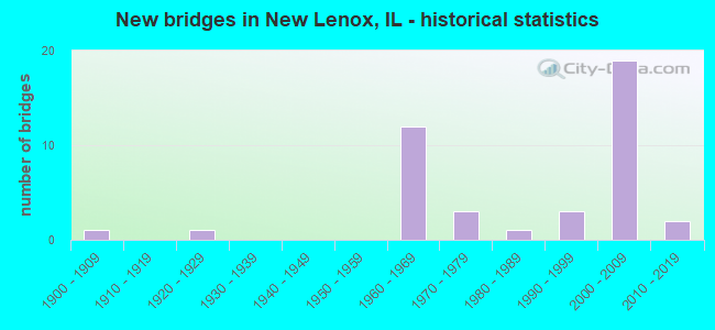
- New bridges - historical statistics
- 11900-1909
- 11920-1929
- 121960-1969
- 31970-1979
- 11980-1989
- 31990-1999
- 192000-2009
- 22010-2019

- Reconstructed bridges - Historical Statistics
- 11980-1989
- 21990-1999
- 12000-2009
- 22010-2019


- Bridge Condition - Deck
- 4.3%Very good
- 52.2%Good
- 21.7%Satisfactory
- 13.0%Fair
- 8.7%Poor

- Bridge Condition - Superstructure
- 21.7%Very good
- 34.8%Good
- 21.7%Satisfactory
- 13.0%Fair
- 4.3%Poor
- 4.3%Critical

- Bridge Condition - Substructure
- 8.7%Very good
- 65.2%Good
- 21.7%Satisfactory
- 4.3%Fair

- Bridge Condition - Channel
- 11.1%Very good
- 33.3%Good
- 33.3%Satisfactory
- 22.2%Fair

- Bridge Condition - Culverts
- 20.0%Very good
- 60.0%Good
- 20.0%Serious
Find on map >> Show street view
Structure Number: 990068, Location: 4.7 M E OF IL-53 (Lat: 41.519972, Lng: -87.991744), Route carried "on" structure: Interstate 80, Year Built: 1964, Year Reconstructed: 2019, Status: Open, Structure Length: 18.80m (61.68ft), Average Daily Traffic: 30,600 (year 2021), Truck Traffic: 33%, Average Future Daily Traffic: 50,757 (year 2032), Design Load: HS 20+Mod, Features Intersected: RR & US-30
Minimum Vertical Clearance: 30+ m (98+ ft), Kilometerpoint: 221.649, Lanes on structure: 2, Lanes under structure: 4, Base Highway Network: Yes, Owner: State Highway Agency, Approaching Roadway Width: 13.4m (44.0ft), Skew: 1 degrees, Material/Design: Steel continuous, Design/Construction: Stringer/Multi-beam, Number Of Spans In Main Unit: 9, Length of Maximum Span: 27.8m (91.2ft), Curb-To-Curb Width: 11.9m (39.0ft), Out-to-Out Width: 12.8m (42.0ft)
Condition: Deck: Satisfactory, Superstructure: Satisfactory, Substructure: Satisfactory, Channel: Satisfactory, Operating Rating: 76.1 metric tons, Method Used To Determine Operating Rating: Load Factor (LF) rating reported by rating factor (RF) method using MS18 loading, Inventory Rating: 45.7 metric tons, Method Used To Determine Inventory Rating: Load Factor (LF) rating reported by rating factor (RF) method using MS18 loading, Structural Evaluation: Equal to present minimum criteria, Deck Geometry: Equal to present minimum criteria, Underclear: Meets minimum limits, Waterway Adequacy: Equal to present desirable criteria, Approach Roadway Alignment: Equal to present desirable criteria, Designated Inspection Frequency: Every 24 months, Inspection Date: March 2020, Deck Structure Type: Concrete Cast-file-Place, Wearing Surface/Protective System: Deck Protection: Epoxy Coated Reinforcing
Find on map >> Show street view
Structure Number: 990069, Location: 4.7 M E OF IL-53 (Lat: 41.519908, Lng: -87.991786), Route carried "on" structure: Interstate 80, Year Built: 1964, Year Reconstructed: 2019, Status: Open, Structure Length: 19.19m (62.96ft), Average Daily Traffic: 30,600 (year 2021), Truck Traffic: 33%, Average Future Daily Traffic: 50,757 (year 2032), Design Load: HS 20+Mod, Features Intersected: RR & US-30
Minimum Vertical Clearance: 30+ m (98+ ft), Kilometerpoint: 221.633, Lanes on structure: 3, Lanes under structure: 4, Base Highway Network: Yes, Owner: State Highway Agency, Approaching Roadway Width: 15.8m (51.8ft), Skew: 1 degrees, Material/Design: Steel continuous, Design/Construction: Stringer/Multi-beam, Number Of Spans In Main Unit: 9, Length of Maximum Span: 27.8m (91.2ft), Curb-To-Curb Width: 14.3m (46.9ft), Out-to-Out Width: 15.3m (50.2ft)
Condition: Deck: Satisfactory, Superstructure: Satisfactory, Substructure: Satisfactory, Channel: Satisfactory, Operating Rating: 66.7 metric tons, Method Used To Determine Operating Rating: Load Factor (LF) rating reported by rating factor (RF) method using MS18 loading, Inventory Rating: 39.9 metric tons, Method Used To Determine Inventory Rating: Load Factor (LF) rating reported by rating factor (RF) method using MS18 loading, Structural Evaluation: Equal to present minimum criteria, Deck Geometry: Meets minimum limits, Underclear: Meets minimum limits, Waterway Adequacy: Equal to present desirable criteria, Approach Roadway Alignment: Equal to present desirable criteria, Designated Inspection Frequency: Every 24 months, Inspection Date: March 2020, Deck Structure Type: Concrete Cast-file-Place, Wearing Surface/Protective System: Deck Protection: Epoxy Coated Reinforcing
Find on map >> Show street view
Structure Number: 990129, Location: 4 M SE OF IL 53 (Lat: 41.468056, Lng: -88.015961), Route carried "on" structure: US 52, Year Built: 1927, Year Reconstructed: 1980, Status: Open, Structure Length: 1.34m (4.40ft), Average Daily Traffic: 8,450 (year 2021), Truck Traffic: 11%, Average Future Daily Traffic: 10,929 (year 2032), Design Load: HS 20, Features Intersected: N BR JACKSON CREEK
Minimum Vertical Clearance: 30+ m (98+ ft), Kilometerpoint: 235.070, Lanes on structure: 2, Base Highway Network: Yes, Owner: State Highway Agency, Approaching Roadway Width: 8.5m (27.9ft), Material/Design: Concrete continuous, Design/Construction: Slab, Number Of Spans In Main Unit: 2, Length of Maximum Span: 6.5m (21.3ft), Curb-To-Curb Width: 13.0m (42.7ft), Out-to-Out Width: 13.6m (44.6ft)
Condition: Deck: Fair, Superstructure: Fair, Substructure: Good, Channel: Fair, Operating Rating: 50.9 metric tons, Method Used To Determine Operating Rating: Load Factor (LF) rating reported by rating factor (RF) method using MS18 loading, Inventory Rating: 30.5 metric tons, Method Used To Determine Inventory Rating: Load Factor (LF) rating reported by rating factor (RF) method using MS18 loading, Structural Evaluation: Somewhat better than minimum adequacy, Deck Geometry: Somewhat better than minimum adequacy, Waterway Adequacy: Equal to present minimum criteria, Approach Roadway Alignment: Equal to present desirable criteria, Length Of Structure Improvement: 1.34m (4.40ft), Designated Inspection Frequency: Every 24 months, Other Special Inspection Frequency: Every 24 months, Inspection Date: May 2021, Other Special Inspection Date: May 2021, Bridge Improvement Cost: $139,000, Roadway Improvement Cost: $14,000, Total Project Cost: $209,000, Deck Structure Type: Concrete Cast-file-Place, Wearing Surface/Protective System: Wearing Surface: Latex Concrete
Find on map >> Show street view
Structure Number: 990197, Location: 3.0 M NE OF US-30 (Lat: 41.542839, Lng: -87.942275), Route carried "on" structure: Other road , Year Built: 1966, Year Reconstructed: 2002, Status: Open, Structure Length: 7.08m (23.23ft), Average Daily Traffic: 9,250 (year 2019), Truck Traffic: 4%, Average Future Daily Traffic: 8,247 (year 2032), Design Load: HS 20+Mod, Features Intersected: I- 80, Facility Carried by Structure: PARKER RD
Minimum Vertical Clearance: 30+ m (98+ ft), Kilometerpoint: 11.619, Lanes on structure: 2, Lanes under structure: 6, Owner: State Highway Agency, Approaching Roadway Width: 7.9m (25.9ft), Skew: 1 degrees, Material/Design: Steel continuous, Design/Construction: Stringer/Multi-beam, Number Of Spans In Main Unit: 4, Length of Maximum Span: 21.1m (69.2ft), Curb-To-Curb Width: 8.5m (27.9ft), Out-to-Out Width: 9.5m (31.2ft)
Condition: Deck: Good, Superstructure: Satisfactory, Substructure: Good, Operating Rating: 87.5 metric tons, Method Used To Determine Operating Rating: Load Factor (LF) rating reported by rating factor (RF) method using MS18 loading, Inventory Rating: 52.5 metric tons, Method Used To Determine Inventory Rating: Load Factor (LF) rating reported by rating factor (RF) method using MS18 loading, Structural Evaluation: Equal to present minimum criteria, Deck Geometry: Meets minimum limits, Underclear: Meets minimum limits, Approach Roadway Alignment: Equal to present desirable criteria, Length Of Structure Improvement: 7.07m (23.20ft), Designated Inspection Frequency: Every 24 months, Inspection Date: Febuary 2020, Bridge Improvement Cost: $139,000, Roadway Improvement Cost: $7,000, Total Project Cost: $167,000, Deck Structure Type: Concrete Cast-file-Place
Find on map >> Show street view
Structure Number: 990203, Location: 4.0 M E OF US-52 (Lat: 41.514256, Lng: -88.004511), Route carried "on" structure: Other road , Year Built: 1965, Status: Open, Structure Length: 6.60m (21.65ft), Average Daily Traffic: 10,900 (year 2019), Truck Traffic: 10%, Average Future Daily Traffic: 12,203 (year 2032), Design Load: HS 15, Features Intersected: I- 80, Facility Carried by Structure: GOUGAR RD
Minimum Vertical Clearance: 30+ m (98+ ft), Kilometerpoint: 9.366, Lanes on structure: 2, Lanes under structure: 4, Base Highway Network: Yes, Owner: State Highway Agency, Approaching Roadway Width: 7.9m (25.9ft), Material/Design: Steel continuous, Design/Construction: Stringer/Multi-beam, Number Of Spans In Main Unit: 4, Length of Maximum Span: 20.4m (66.9ft), Curb-To-Curb Width: 7.9m (25.9ft), Out-to-Out Width: 15.8m (51.8ft)
Condition: Deck: Poor, Superstructure: Poor, Substructure: Fair, Operating Rating: 60.3 metric tons, Method Used To Determine Operating Rating: Load Factor (LF) rating reported by rating factor (RF) method using MS18 loading, Inventory Rating: 32.1 metric tons, Method Used To Determine Inventory Rating: Load Factor (LF) rating reported by rating factor (RF) method using MS18 loading, Structural Evaluation: Meets minimum limits, Deck Geometry: High priority of corrective action, Underclear: Meets minimum limits, Approach Roadway Alignment: Equal to present desirable criteria, Length Of Structure Improvement: 8.11m (26.61ft), Designated Inspection Frequency: Every 12 months, Inspection Date: November 2021, Bridge Improvement Cost: $938,000, Roadway Improvement Cost: $94,000, Total Project Cost: $1,407,000, Deck Structure Type: Concrete Cast-file-Place
Find on map >> Show street view
Structure Number: 990205, Location: 0.5 M N OF US-30 (Lat: 41.531117, Lng: -87.985719), Route carried "on" structure: Other road , Year Built: 1965, Year Reconstructed: 1998, Status: Temporarily open, Structure Length: 9.57m (31.40ft), Average Daily Traffic: 3,950 (year 2019), Truck Traffic: 2%, Average Future Daily Traffic: 3,688 (year 2032), Design Load: HS 15, Features Intersected: I- 80, Facility Carried by Structure: FRANCIS RD
Minimum Vertical Clearance: 30+ m (98+ ft), Kilometerpoint: 1.593, Lanes on structure: 2, Lanes under structure: 6, Owner: State Highway Agency, Approaching Roadway Width: 7.9m (25.9ft), Material/Design: Steel, Design/Construction: Stringer/Multi-beam, Number Of Spans In Main Unit: 4, Length of Maximum Span: 29.1m (95.5ft), Curb-To-Curb Width: 7.9m (25.9ft), Out-to-Out Width: 9.7m (31.8ft)
Condition: Deck: Poor, Superstructure: Critical, Substructure: Satisfactory, Structural Evaluation: High priority of replacement, Deck Geometry: High priority of corrective action, Underclear: Meets minimum limits, Approach Roadway Alignment: Somewhat better than minimum adequacy, Length Of Structure Improvement: 9.57m (31.40ft), Designated Inspection Frequency: Every 12 months, Other Special Inspection Frequency: Every 6 months, Inspection Date: December 2021, Other Special Inspection Date: December 2021, Bridge Improvement Cost: $201,000, Roadway Improvement Cost: $10,000, Total Project Cost: $241,000, Deck Structure Type: Concrete Cast-file-Place, Wearing Surface/Protective System: Wearing Surface: Latex Concrete
Find on map >> Show street view
Structure Number: 990316, Location: 0.20 M.S. OF I-80 (Lat: 41.536069, Lng: -87.960497), Route carried "on" structure: Interstate 355, Year Built: 2007, Status: Open, Structure Length: 5.47m (17.95ft), Average Daily Traffic: 13,850 (year 2020), Truck Traffic: 17%, Average Future Daily Traffic: 20,786 (year 2032), Design Load: HS 20+Mod, Features Intersected: I-80 EB TO I-355 NB
Minimum Vertical Clearance: 30+ m (98+ ft), Kilometerpoint: 1.030, Lanes on structure: 2, Lanes under structure: 1, Base Highway Network: Yes, Toll: On toll road, Owner: State Toll Authority, Approaching Roadway Width: 7.3m (24.0ft), Skew: 2 degrees, Material/Design: Steel continuous, Design/Construction: Stringer/Multi-beam, Number Of Spans In Main Unit: 1, Length of Maximum Span: 52.4m (171.9ft), Curb-To-Curb Width: 7.3m (24.0ft), Out-to-Out Width: 15.0m (49.2ft)
Condition: Deck: Good, Superstructure: Good, Substructure: Good, Operating Rating: 97.2 metric tons, Method Used To Determine Operating Rating: Load Factor (LF) rating reported by rating factor (RF) method using MS18 loading, Inventory Rating: 77.1 metric tons, Method Used To Determine Inventory Rating: Load Factor (LF) rating reported by rating factor (RF) method using MS18 loading, Structural Evaluation: Better than present minimum criteria, Deck Geometry: High priority of replacement, Underclear: High priority of corrective action, Approach Roadway Alignment: Equal to present desirable criteria, Designated Inspection Frequency: Every 24 months, Inspection Date: August 2019, Deck Structure Type: Concrete Cast-file-Place
Find on map >> Show street view
Structure Number: 990317, Location: 0.65 M S OF US-6 (Lat: 41.539133, Lng: -87.956633), Route carried "on" structure: Other road , Year Built: 2007, Status: Open, Structure Length: 6.49m (21.29ft), Average Daily Traffic: 6,000 (year 2021), Average Future Daily Traffic: 7,253 (year 2032), Design Load: HS 20, Features Intersected: I- 80, Facility Carried by Structure: I- 80 EB TO I-355
Minimum Vertical Clearance: 30+ m (98+ ft), Kilometerpoint: 1.368, Lanes on structure: 1, Lanes under structure: 6, Base Highway Network: Yes (Inventory Route: 10080041, Subroute: 50), Owner: State Highway Agency, Approaching Roadway Width: 11.6m (38.1ft), Material/Design: Prestressed concrete continuous, Design/Construction: Stringer/Multi-beam, Number Of Spans In Main Unit: 2, Length of Maximum Span: 32.4m (106.3ft), Curb-To-Curb Width: 11.6m (38.1ft), Out-to-Out Width: 12.5m (41.0ft)
Condition: Deck: Good, Superstructure: Good, Substructure: Good, Operating Rating: 59.6 metric tons, Method Used To Determine Operating Rating: Load Factor (LF) rating reported by rating factor (RF) method using MS18 loading, Inventory Rating: 35.6 metric tons, Method Used To Determine Inventory Rating: Load Factor (LF) rating reported by rating factor (RF) method using MS18 loading, Structural Evaluation: Better than present minimum criteria, Deck Geometry: Somewhat better than minimum adequacy, Underclear: Equal to present minimum criteria, Approach Roadway Alignment: Equal to present desirable criteria, Designated Inspection Frequency: Every 24 months, Inspection Date: August 2019, Deck Structure Type: Concrete Cast-file-Place, Wearing Surface/Protective System: Deck Protection: Epoxy Coated Reinforcing
Find on map >> Show street view
Structure Number: 990318, Location: I-80 & I-355 INTERCH (Lat: 41.538472, Lng: -87.962303), Route carried "on" structure: Interstate 355, Year Built: 2007, Status: Open, Structure Length: 7.50m (24.61ft), Average Daily Traffic: 13,850 (year 2020), Truck Traffic: 17%, Average Future Daily Traffic: 20,786 (year 2032), Design Load: HS 20, Features Intersected: I- 80
Minimum Vertical Clearance: 30+ m (98+ ft), Kilometerpoint: 1.304, Lanes on structure: 2, Lanes under structure: 6, Base Highway Network: Yes, Toll: On toll road, Owner: State Toll Authority, Approaching Roadway Width: 7.3m (24.0ft), Skew: 1 degrees, Material/Design: Prestressed concrete continuous, Design/Construction: Stringer/Multi-beam, Number Of Spans In Main Unit: 2, Length of Maximum Span: 37.5m (123.0ft), Curb-To-Curb Width: 7.3m (24.0ft), Out-to-Out Width: 13.1m (43.0ft)
Condition: Deck: Good, Superstructure: Good, Substructure: Good, Operating Rating: 60.9 metric tons, Method Used To Determine Operating Rating: Load Factor (LF) rating reported by rating factor (RF) method using MS18 loading, Inventory Rating: 36.6 metric tons, Method Used To Determine Inventory Rating: Load Factor (LF) rating reported by rating factor (RF) method using MS18 loading, Structural Evaluation: Better than present minimum criteria, Deck Geometry: High priority of replacement, Underclear: Equal to present minimum criteria, Approach Roadway Alignment: Equal to present desirable criteria, Designated Inspection Frequency: Every 24 months, Inspection Date: August 2019, Deck Structure Type: Concrete Cast-file-Place
Find on map >> Show street view
Structure Number: 990319, Location: 0.5 M S OF I-355 (Lat: 41.537506, Lng: -87.966261), Route carried "on" structure: Other road , Year Built: 2007, Status: Open, Structure Length: 11.09m (36.38ft), Average Daily Traffic: 12,300 (year 2021), Truck Traffic: 3%, Average Future Daily Traffic: 10,996 (year 2032), Design Load: HS 20, Features Intersected: I- 80, Facility Carried by Structure: CEDAR RD
Minimum Vertical Clearance: 30+ m (98+ ft), Kilometerpoint: 9.125, Lanes on structure: 2, Lanes under structure: 6, Base Highway Network: Yes, Owner: State Highway Agency, Approaching Roadway Width: 17.1m (56.1ft), Skew: 2 degrees, Material/Design: Steel continuous, Design/Construction: Stringer/Multi-beam, Number Of Spans In Main Unit: 2, Length of Maximum Span: 48.6m (159.4ft), Curb-To-Curb Width: 17.1m (56.1ft), Out-to-Out Width: 18.0m (59.1ft)
Condition: Deck: Good, Superstructure: Good, Substructure: Good, Operating Rating: 55.1 metric tons, Method Used To Determine Operating Rating: Load Factor (LF) rating reported by rating factor (RF) method using MS18 loading, Inventory Rating: 33.0 metric tons, Method Used To Determine Inventory Rating: Load Factor (LF) rating reported by rating factor (RF) method using MS18 loading, Structural Evaluation: Better than present minimum criteria, Deck Geometry: Superior to present desirable criteria, Underclear: High priority of corrective action, Approach Roadway Alignment: Equal to present desirable criteria, Designated Inspection Frequency: Every 24 months, Inspection Date: September 2020, Deck Structure Type: Concrete Cast-file-Place, Wearing Surface/Protective System: Deck Protection: Epoxy Coated Reinforcing
Find on map >> Show street view
Structure Number: 99032, Location: 0.4 M W OF US 6 (Lat: 41.544139, Lng: -87.966817), Route carried "on" structure: Other road , Year Built: 2007, Status: Open, Structure Length: 12.52m (41.08ft), Average Daily Traffic: 12,300 (year 2021), Truck Traffic: 3%, Average Future Daily Traffic: 10,996 (year 2032), Design Load: HS 20+Mod, Features Intersected: I-355, Facility Carried by Structure: CEDAR RD
Minimum Vertical Clearance: 30+ m (98+ ft), Kilometerpoint: 8.384, Lanes on structure: 2, Lanes under structure: 4, Base Highway Network: Yes, Owner: County Highway Agency, Approaching Roadway Width: 13.4m (44.0ft), Skew: 4 degrees, Material/Design: Steel continuous, Design/Construction: Stringer/Multi-beam, Number Of Spans In Main Unit: 2, Number Of Approach Spans: 2, Length of Maximum Span: 56.2m (184.4ft), Curb-To-Curb Width: 13.4m (44.0ft), Out-to-Out Width: 14.4m (47.2ft)
Condition: Deck: Good, Superstructure: Good, Substructure: Good, Operating Rating: 63.8 metric tons, Method Used To Determine Operating Rating: Load Factor (LF) rating reported by rating factor (RF) method using MS18 loading, Inventory Rating: 38.2 metric tons, Method Used To Determine Inventory Rating: Load Factor (LF) rating reported by rating factor (RF) method using MS18 loading, Structural Evaluation: Better than present minimum criteria, Deck Geometry: Equal to present minimum criteria, Underclear: Somewhat better than minimum adequacy, Approach Roadway Alignment: Equal to present desirable criteria, Designated Inspection Frequency: Every 24 months, Inspection Date: August 2019, Deck Structure Type: Concrete Cast-file-Place, Wearing Surface/Protective System: Deck Protection: Epoxy Coated Reinforcing
Find on map >> Show street view
Structure Number: 990321, Location: 0.9 M N OF I-80 (Lat: 41.548139, Lng: -87.974383), Route carried "on" structure: US 6, Year Built: 2007, Status: Open, Structure Length: 12.84m (42.13ft), Average Daily Traffic: 20,200 (year 2021), Truck Traffic: 3%, Average Future Daily Traffic: 12,672 (year 2032), Design Load: HS 20, Features Intersected: I-355
Minimum Vertical Clearance: 30+ m (98+ ft), Kilometerpoint: 245.837, Lanes on structure: 4, Lanes under structure: 6, Base Highway Network: Yes, Owner: State Highway Agency, Approaching Roadway Width: 21.3m (69.9ft), Skew: 24 degrees, Material/Design: Steel continuous, Design/Construction: Stringer/Multi-beam, Number Of Spans In Main Unit: 2, Number Of Approach Spans: 2, Length of Maximum Span: 55.1m (180.8ft), Curb-To-Curb Width: 21.3m (69.9ft), Out-to-Out Width: 27.2m (89.2ft)
Condition: Deck: Good, Superstructure: Good, Substructure: Good, Operating Rating: 61.6 metric tons, Method Used To Determine Operating Rating: Load Factor (LF) rating reported by rating factor (RF) method using MS18 loading, Inventory Rating: 36.9 metric tons, Method Used To Determine Inventory Rating: Load Factor (LF) rating reported by rating factor (RF) method using MS18 loading, Structural Evaluation: Better than present minimum criteria, Deck Geometry: Superior to present desirable criteria, Underclear: Somewhat better than minimum adequacy, Approach Roadway Alignment: Superior to present desirable criteria, Designated Inspection Frequency: Every 24 months, Inspection Date: August 2019, Deck Structure Type: Concrete Cast-file-Place, Wearing Surface/Protective System: Deck Protection: Epoxy Coated Reinforcing
Find on map >> Show street view
Structure Number: 990322, Location: 1M N OF US6 (Lat: 41.551100, Lng: -87.978669), Route carried "on" structure: Interstate 355, Year Built: 2007, Status: Open, Structure Length: 16.89m (55.41ft), Average Daily Traffic: 19,000 (year 2020), Truck Traffic: 17%, Average Future Daily Traffic: 31,514 (year 2032), Design Load: HS 20, Features Intersected: SPRING CREEK
Minimum Vertical Clearance: 30+ m (98+ ft), Kilometerpoint: 3.090, Lanes on structure: 3, Base Highway Network: Yes, Toll: On toll road, Owner: State Toll Authority, Approaching Roadway Width: 11.0m (36.1ft), Skew: 1 degrees, Material/Design: Prestressed concrete continuous, Design/Construction: Stringer/Multi-beam, Number Of Spans In Main Unit: 5, Length of Maximum Span: 27.3m (89.6ft), Curb-To-Curb Width: 11.0m (36.1ft), Out-to-Out Width: 19.5m (64.0ft)
Condition: Deck: Good, Superstructure: Very good, Substructure: Good, Channel: Very good, Operating Rating: 57.7 metric tons, Method Used To Determine Operating Rating: Load Factor (LF) rating reported by rating factor (RF) method using MS18 loading, Inventory Rating: 34.7 metric tons, Method Used To Determine Inventory Rating: Load Factor (LF) rating reported by rating factor (RF) method using MS18 loading, Structural Evaluation: Better than present minimum criteria, Deck Geometry: High priority of replacement, Waterway Adequacy: Superior to present desirable criteria, Approach Roadway Alignment: Equal to present desirable criteria, Designated Inspection Frequency: Every 24 months, Inspection Date: April 2020, Deck Structure Type: Concrete Cast-file-Place
Find on map >> Show street view
Structure Number: 990323, Location: 1M N OF US6 (Lat: 41.551206, Lng: -87.978833), Route carried "on" structure: Interstate 355, Year Built: 2007, Status: Open, Structure Length: 16.89m (55.41ft), Average Daily Traffic: 19,000 (year 2020), Truck Traffic: 17%, Average Future Daily Traffic: 31,514 (year 2032), Design Load: HS 20, Features Intersected: SPRING CREEK
Minimum Vertical Clearance: 30+ m (98+ ft), Kilometerpoint: 3.106, Lanes on structure: 3, Base Highway Network: Yes, Toll: On toll road, Owner: State Toll Authority, Approaching Roadway Width: 11.0m (36.1ft), Material/Design: Prestressed concrete continuous, Design/Construction: Stringer/Multi-beam, Number Of Spans In Main Unit: 5, Length of Maximum Span: 27.3m (89.6ft), Curb-To-Curb Width: 11.0m (36.1ft), Out-to-Out Width: 15.2m (49.9ft)
Condition: Deck: Good, Superstructure: Very good, Substructure: Good, Channel: Very good, Operating Rating: 64.2 metric tons, Method Used To Determine Operating Rating: Load Factor (LF) rating reported by rating factor (RF) method using MS18 loading, Inventory Rating: 38.6 metric tons, Method Used To Determine Inventory Rating: Load Factor (LF) rating reported by rating factor (RF) method using MS18 loading, Structural Evaluation: Better than present minimum criteria, Deck Geometry: High priority of replacement, Waterway Adequacy: Superior to present desirable criteria, Approach Roadway Alignment: Equal to present desirable criteria, Designated Inspection Frequency: Every 24 months, Inspection Date: April 2020, Deck Structure Type: Concrete Cast-file-Place
Find on map >> Show street view
Structure Number: 993021, Location: .25M E OF CEDAR RD (Lat: 41.540494, Lng: -87.963681), Route carried "on" structure: Interstate 355, Year Built: 2008, Status: Open, Structure Length: 0.87m (2.85ft), Average Daily Traffic: 19,850 (year 2020), Truck Traffic: 12%, Average Future Daily Traffic: 23,870 (year 2032), Design Load: HS 20, Features Intersected: HICKORY CR TRIB SWAL
Minimum Vertical Clearance: 30+ m (98+ ft), Kilometerpoint: 1.529, Lanes on structure: 3, Base Highway Network: Yes, Toll: On toll road, Owner: State Toll Authority, Approaching Roadway Width: 25.9m (85.0ft), Material/Design: Concrete, Design/Construction: Culvert, Number Of Spans In Main Unit: 2, Length of Maximum Span: 2.4m (7.9ft)
Condition: Channel: Fair, Culverts: Good, Operating Rating: 89.1 metric tons, Method Used To Determine Operating Rating: Load Factor (LF) rating reported by rating factor (RF) method using MS18 loading, Inventory Rating: 89.1 metric tons, Method Used To Determine Inventory Rating: Load Factor (LF) rating reported by rating factor (RF) method using MS18 loading, Structural Evaluation: Better than present minimum criteria, Waterway Adequacy: Superior to present desirable criteria, Approach Roadway Alignment: Equal to present desirable criteria, Designated Inspection Frequency: Every 24 months, Inspection Date: April 2020
Find on map >> Show street view
Structure Number: 993241, Location: 0.8 MI NO US30 (Lat: 41.523183, Lng: -87.942928), Route carried "on" structure: Other road , Year Built: 1968, Year Reconstructed: 2006, Status: Open, Structure Length: 3.29m (10.79ft), Average Daily Traffic: 4,750 (year 2019), Truck Traffic: 5%, Average Future Daily Traffic: 3,822 (year 2032), Design Load: HS 20, Features Intersected: HICKORY CREEK, Facility Carried by Structure: MARLEY RD
Minimum Vertical Clearance: 30+ m (98+ ft), Kilometerpoint: 0.869, Lanes on structure: 2, Owner: Town or Township Highway Agency, Approaching Roadway Width: 10.4m (34.1ft), Skew: 2 degrees, Material/Design: Concrete continuous, Design/Construction: Slab, Number Of Spans In Main Unit: 3, Length of Maximum Span: 12.5m (41.0ft), Curb-To-Curb Width: 9.2m (30.2ft), Out-to-Out Width: 9.2m (30.2ft)
Condition: Deck: Fair, Superstructure: Fair, Substructure: Satisfactory, Channel: Fair, Operating Rating: 41.8 metric tons, Method Used To Determine Operating Rating: Load Factor (LF) rating reported by rating factor (RF) method using MS18 loading, Inventory Rating: 24.9 metric tons, Method Used To Determine Inventory Rating: Load Factor (LF) rating reported by rating factor (RF) method using MS18 loading, Structural Evaluation: Somewhat better than minimum adequacy, Deck Geometry: Meets minimum limits, Waterway Adequacy: Equal to present desirable criteria, Approach Roadway Alignment: Equal to present desirable criteria, Designated Inspection Frequency: Every 24 months, Inspection Date: July 2020, Deck Structure Type: Concrete Cast-file-Place, Wearing Surface/Protective System: Wearing Surface: Other
Find on map >> Show street view
Structure Number: 99332, Location: 0.5 MI E GOUGAR ROAD (Lat: 41.482656, Lng: -87.993219), Route carried "on" structure: Other road , Year Built: 1965, Status: Open, Structure Length: 0.76m (2.49ft), Average Daily Traffic: 7,100 (year 2019), Truck Traffic: 15%, Average Future Daily Traffic: 19,000 (year 2037), Design Load: HS 20, Features Intersected: N. BR. JACKSON CREEK, Facility Carried by Structure: LARAWAY ROAD
Minimum Vertical Clearance: 30+ m (98+ ft), Kilometerpoint: 8.996, Lanes on structure: 2, Base Highway Network: Yes, Owner: County Highway Agency, Approaching Roadway Width: 9.8m (32.2ft), Skew: 3 degrees, Material/Design: Concrete, Design/Construction: Culvert, Number Of Spans In Main Unit: 2, Length of Maximum Span: 3.7m (12.1ft), Curb-To-Curb Width: 11.0m (36.1ft), Out-to-Out Width: 15.5m (50.9ft)
Condition: Channel: Good, Culverts: Good, Operating Rating: 74.2 metric tons, Method Used To Determine Operating Rating: Load Factor (LF) rating reported by rating factor (RF) method using MS18 loading, Inventory Rating: 44.4 metric tons, Method Used To Determine Inventory Rating: Load Factor (LF) rating reported by rating factor (RF) method using MS18 loading, Structural Evaluation: Better than present minimum criteria, Deck Geometry: Meets minimum limits, Waterway Adequacy: Somewhat better than minimum adequacy, Approach Roadway Alignment: Equal to present desirable criteria, Designated Inspection Frequency: Every 24 months, Inspection Date: April 2021
Find on map >> Show street view
Structure Number: 99334, Location: 0.6MI N LARAWAY RD (Lat: 41.492075, Lng: -87.965094), Route carried "on" structure: Other road , Year Built: 1992, Status: Open, Structure Length: 1.35m (4.43ft), Average Daily Traffic: 10,600 (year 2019), Truck Traffic: 7%, Average Future Daily Traffic: 11,400 (year 2032), Design Load: HS 20, Features Intersected: N. BR JACKSON CREEK, Facility Carried by Structure: CEDAR ROAD
Minimum Vertical Clearance: 30+ m (98+ ft), Kilometerpoint: 2.269, Lanes on structure: 2, Base Highway Network: Yes, Owner: County Highway Agency, Approaching Roadway Width: 12.2m (40.0ft), Material/Design: Steel, Design/Construction: Stringer/Multi-beam, Number Of Spans In Main Unit: 1, Length of Maximum Span: 12.1m (39.7ft), Curb-To-Curb Width: 12.2m (40.0ft), Out-to-Out Width: 12.2m (40.0ft)
Condition: Deck: Satisfactory, Superstructure: Good, Substructure: Good, Channel: Good, Operating Rating: 44.1 metric tons, Method Used To Determine Operating Rating: Assigned rating based on Load Factor Design (LFD) reported by rating factor (RF) using MS18 loading, Inventory Rating: 32.4 metric tons, Method Used To Determine Inventory Rating: Assigned rating based on Load Factor Design (LFD) reported by rating factor (RF) using MS18 loading, Structural Evaluation: Better than present minimum criteria, Deck Geometry: Somewhat better than minimum adequacy, Waterway Adequacy: Equal to present desirable criteria, Approach Roadway Alignment: Equal to present desirable criteria, Designated Inspection Frequency: Every 48 months, Inspection Date: July 2021, Deck Structure Type: Concrete Cast-file-Place, Wearing Surface/Protective System: Deck Protection: Epoxy Coated Reinforcing
Find on map >> Show street view
Structure Number: 993363, Location: 1.5M E CEDAR RD (Lat: 41.531969, Lng: -87.937536), Route carried "on" structure: Other road , Year Built: 2003, Status: Open, Structure Length: 2.23m (7.32ft), Average Daily Traffic: 11,700 (year 2019), Truck Traffic: 6%, Average Future Daily Traffic: 13,544 (year 2032), Design Load: HS 20, Features Intersected: MARLEY CREEK, Facility Carried by Structure: FRANCIS RD
Minimum Vertical Clearance: 30+ m (98+ ft), Kilometerpoint: 5.713, Lanes on structure: 2, Owner: County Highway Agency, Approaching Roadway Width: 12.2m (40.0ft), Material/Design: Steel continuous, Design/Construction: Stringer/Multi-beam, Number Of Spans In Main Unit: 2, Length of Maximum Span: 10.5m (34.4ft), Curb-To-Curb Width: 12.2m (40.0ft), Out-to-Out Width: 13.2m (43.3ft)
Condition: Deck: Good, Superstructure: Good, Substructure: Good, Channel: Satisfactory, Operating Rating: 53.8 metric tons, Method Used To Determine Operating Rating: Assigned rating based on Load Factor Design (LFD) reported by rating factor (RF) using MS18 loading, Inventory Rating: 32.4 metric tons, Method Used To Determine Inventory Rating: Assigned rating based on Load Factor Design (LFD) reported by rating factor (RF) using MS18 loading, Structural Evaluation: Better than present minimum criteria, Deck Geometry: Somewhat better than minimum adequacy, Waterway Adequacy: Superior to present desirable criteria, Approach Roadway Alignment: Equal to present desirable criteria, Designated Inspection Frequency: Every 48 months, Inspection Date: July 2020, Deck Structure Type: Concrete Cast-file-Place, Wearing Surface/Protective System: Deck Protection: Epoxy Coated Reinforcing
Find on map >> Show street view
Structure Number: 993381, Location: 1.3 MI S LARAWAY RD (Lat: 41.463975, Lng: -87.964108), Route carried "on" structure: Other road , Year Built: 2010, Status: Open, Structure Length: 3.21m (10.53ft), Average Daily Traffic: 7,400 (year 2019), Truck Traffic: 7%, Average Future Daily Traffic: 4,400 (year 2032), Design Load: HS 20, Features Intersected: JACKSON CREEK, Facility Carried by Structure: CEDAR RD
Minimum Vertical Clearance: 30+ m (98+ ft), Kilometerpoint: 5.391, Lanes on structure: 2, Base Highway Network: Yes, Owner: County Highway Agency, Approaching Roadway Width: 12.2m (40.0ft), Skew: 3 degrees, Material/Design: Steel, Design/Construction: Stringer/Multi-beam, Number Of Spans In Main Unit: 1, Length of Maximum Span: 31.2m (102.4ft), Curb-To-Curb Width: 12.2m (40.0ft), Out-to-Out Width: 13.0m (42.7ft)
Condition: Deck: Good, Superstructure: Very good, Substructure: Very good, Channel: Good, Operating Rating: 44.1 metric tons, Method Used To Determine Operating Rating: Assigned rating based on Load Factor Design (LFD) reported by rating factor (RF) using MS18 loading, Inventory Rating: 32.4 metric tons, Method Used To Determine Inventory Rating: Assigned rating based on Load Factor Design (LFD) reported by rating factor (RF) using MS18 loading, Structural Evaluation: Equal to present desirable criteria, Deck Geometry: Somewhat better than minimum adequacy, Waterway Adequacy: Superior to present desirable criteria, Approach Roadway Alignment: Equal to present desirable criteria, Designated Inspection Frequency: Every 24 months, Inspection Date: July 2020, Deck Structure Type: Concrete Cast-file-Place, Wearing Surface/Protective System: Deck Protection: Epoxy Coated Reinforcing
Find on map >> Show street view
Structure Number: 99435, Location: 0.2 MI NORTH US 30 (Lat: 41.519589, Lng: -87.975672), Route carried "on" structure: Other road , Year Built: 1974, Status: Open, Structure Length: 4.48m (14.70ft), Average Daily Traffic: 600 (year 2019), Truck Traffic: 9%, Average Future Daily Traffic: 5,498 (year 2032), Design Load: HS 20, Features Intersected: HICKORY CREEK, Facility Carried by Structure: VINE STREET
Minimum Vertical Clearance: 30+ m (98+ ft), Kilometerpoint: 1.175, Lanes on structure: 2, Owner: Town or Township Highway Agency, Approaching Roadway Width: 9.1m (29.9ft), Skew: 4 degrees, Material/Design: Concrete continuous, Design/Construction: Slab, Number Of Spans In Main Unit: 4, Length of Maximum Span: 12.2m (40.0ft), Curb or Sidewalk Widths: Left: 1.5m (4.9ft), Right: 0.0m, Curb-To-Curb Width: 8.9m (29.2ft), Out-to-Out Width: 11.3m (37.1ft)
Condition: Deck: Satisfactory, Superstructure: Satisfactory, Substructure: Good, Channel: Satisfactory, Operating Rating: 67.1 metric tons, Method Used To Determine Operating Rating: Load Factor (LF) rating reported by rating factor (RF) method using MS18 loading, Inventory Rating: 40.2 metric tons, Method Used To Determine Inventory Rating: Load Factor (LF) rating reported by rating factor (RF) method using MS18 loading, Structural Evaluation: Equal to present minimum criteria, Deck Geometry: Somewhat better than minimum adequacy, Waterway Adequacy: Equal to present desirable criteria, Approach Roadway Alignment: Equal to present desirable criteria, Designated Inspection Frequency: Every 24 months, Inspection Date: July 2020, Deck Structure Type: Concrete Cast-file-Place, Wearing Surface/Protective System: Wearing Surface: Bituminous
Find on map >> Show street view
Structure Number: 994358, Location: 0.3 M NO OF US30 (Lat: 41.517100, Lng: -87.945156), Route carried "on" structure: Other road , Year Built: 1984, Status: Open, Structure Length: 4.36m (14.30ft), Average Daily Traffic: 4,750 (year 2019), Truck Traffic: 5%, Average Future Daily Traffic: 3,822 (year 2032), Design Load: HS 20, Features Intersected: METRA RR, Facility Carried by Structure: MARLEY ROAD
Minimum Vertical Clearance: 30+ m (98+ ft), Kilometerpoint: 1.593, Lanes on structure: 2, Owner: Town or Township Highway Agency, Approaching Roadway Width: 11.6m (38.1ft), Material/Design: Prestressed concrete, Design/Construction: Box Beam or Girders - Multiple, Number Of Spans In Main Unit: 3, Length of Maximum Span: 16.5m (54.1ft), Curb-To-Curb Width: 8.8m (28.9ft), Out-to-Out Width: 9.8m (32.2ft)
Condition: Deck: Fair, Superstructure: Fair, Substructure: Good, Operating Rating: 63.8 metric tons, Method Used To Determine Operating Rating: Load Factor (LF) rating reported by rating factor (RF) method using MS18 loading, Inventory Rating: 38.2 metric tons, Method Used To Determine Inventory Rating: Load Factor (LF) rating reported by rating factor (RF) method using MS18 loading, Structural Evaluation: Somewhat better than minimum adequacy, Deck Geometry: Meets minimum limits, Underclear: Better than present minimum criteria, Approach Roadway Alignment: Equal to present minimum criteria, Designated Inspection Frequency: Every 24 months, Inspection Date: July 2020, Deck Structure Type: Concrete Precast Panels, Wearing Surface/Protective System: Wearing Surface: Bituminous, Membrane: Built-up
Find on map >> Show street view
Structure Number: 994559, Location: 3.5 M S US-30 (Lat: 41.461522, Lng: -87.925453), Route carried "on" structure: Other road , Year Built: 1996, Status: Open, Structure Length: 1.41m (4.63ft), Average Daily Traffic: 2,600 (year 2019), Truck Traffic: 6%, Average Future Daily Traffic: 1,810 (year 2032), Design Load: HS 20, Features Intersected: JACKSON CREEKTRIB, Facility Carried by Structure: SCHOOL HOUSE RD
Minimum Vertical Clearance: 30+ m (98+ ft), Kilometerpoint: 7.966, Lanes on structure: 2, Owner: Town or Township Highway Agency, Approaching Roadway Width: 8.5m (27.9ft), Material/Design: Prestressed concrete, Design/Construction: Box Beam or Girders - Multiple, Number Of Spans In Main Unit: 1, Length of Maximum Span: 12.9m (42.3ft), Curb-To-Curb Width: 8.5m (27.9ft), Out-to-Out Width: 8.5m (27.9ft)
Condition: Deck: Satisfactory, Superstructure: Satisfactory, Substructure: Good, Channel: Satisfactory, Operating Rating: 44.1 metric tons, Method Used To Determine Operating Rating: Assigned rating based on Load Factor Design (LFD) reported by rating factor (RF) using MS18 loading, Inventory Rating: 32.4 metric tons, Method Used To Determine Inventory Rating: Assigned rating based on Load Factor Design (LFD) reported by rating factor (RF) using MS18 loading, Structural Evaluation: Equal to present minimum criteria, Deck Geometry: Meets minimum limits, Waterway Adequacy: Equal to present desirable criteria, Approach Roadway Alignment: Equal to present desirable criteria, Designated Inspection Frequency: Every 24 months, Inspection Date: July 2020, Deck Structure Type: Concrete Precast Panels, Wearing Surface/Protective System: Wearing Surface: Bituminous, Membrane: Built-up
Find on map >> Show street view
Structure Number: 994562, Location: 0.4 MI NO BAKER RD (Lat: 41.459789, Lng: -87.983347), Route carried "on" structure: Other road , Year Built: 2001, Status: Open, Structure Length: 1.64m (5.38ft), Average Daily Traffic: 4,400 (year 2019), Truck Traffic: 4%, Average Future Daily Traffic: 7,241 (year 2032), Design Load: HS 20, Features Intersected: JACKSON CREEK, Facility Carried by Structure: EASTERN AVENUE
Minimum Vertical Clearance: 30+ m (98+ ft), Kilometerpoint: 4.120, Lanes on structure: 2, Owner: Town or Township Highway Agency, Approaching Roadway Width: 8.5m (27.9ft), Material/Design: Prestressed concrete, Design/Construction: Box Beam or Girders - Multiple, Number Of Spans In Main Unit: 1, Length of Maximum Span: 15.6m (51.2ft), Curb-To-Curb Width: 8.5m (27.9ft), Out-to-Out Width: 8.5m (27.9ft)
Condition: Deck: Very good, Superstructure: Very good, Substructure: Very good, Channel: Good, Operating Rating: 53.8 metric tons, Method Used To Determine Operating Rating: Assigned rating based on Load Factor Design (LFD) reported by rating factor (RF) using MS18 loading, Inventory Rating: 32.4 metric tons, Method Used To Determine Inventory Rating: Assigned rating based on Load Factor Design (LFD) reported by rating factor (RF) using MS18 loading, Structural Evaluation: Equal to present desirable criteria, Deck Geometry: Meets minimum limits, Waterway Adequacy: Equal to present desirable criteria, Approach Roadway Alignment: Equal to present desirable criteria, Designated Inspection Frequency: Every 48 months, Inspection Date: May 2020, Deck Structure Type: Concrete Precast Panels, Wearing Surface/Protective System: Wearing Surface: Bituminous, Membrane: Built-up
Find on map >> Show street view
Structure Number: 996498, Location: 0.06 M E of Marley R (Lat: 41.518178, Lng: -87.933775), Route carried "on" structure: City street , Year Built: 2016, Status: Open, Structure Length: 0.82m (2.69ft), Average Daily Traffic: 25 (year 2015), Truck Traffic: 8%, Average Future Daily Traffic: 20 (year 2040), Design Load: HS 25 or greater, Features Intersected: Trib to Hickory Crk, Facility Carried by Structure: Georgia's Way
Minimum Vertical Clearance: 30+ m (98+ ft), Kilometerpoint: 0.933, Lanes on structure: 2, Owner: City or Municipal Highway Agency, Approaching Roadway Width: 9.4m (30.8ft), Skew: 3 degrees, Material/Design: Concrete, Design/Construction: Culvert, Number Of Spans In Main Unit: 2, Length of Maximum Span: 3.8m (12.5ft), Curb or Sidewalk Widths: Left: 3.0m (9.8ft), Right: 1.2m (3.9ft), Curb-To-Curb Width: 9.4m (30.8ft)
Condition: Channel: Satisfactory, Culverts: Very good, Operating Rating: 54.1 metric tons, Method Used To Determine Operating Rating: Field evaluation and documented engineering judgment, Inventory Rating: 32.4 metric tons, Method Used To Determine Inventory Rating: Field evaluation and documented engineering judgment, Structural Evaluation: Equal to present desirable criteria, Deck Geometry: Better than present minimum criteria, Waterway Adequacy: Superior to present desirable criteria, Approach Roadway Alignment: Equal to present desirable criteria, Designated Inspection Frequency: Every 48 months, Inspection Date: June 2019
Find on map >> Show street view
Structure Number: 996701, Location: .4M N OF LARAWAY RD (Lat: 41.488406, Lng: -87.984200), Route carried "on" structure: Other road , Year Built: 1977, Status: Open, Structure Length: 0.94m (3.08ft), Average Daily Traffic: 4,400 (year 2019), Truck Traffic: 4%, Average Future Daily Traffic: 7,241 (year 2032), Features Intersected: JACKSON CREEK, Facility Carried by Structure: NELSON RD
Minimum Vertical Clearance: 30+ m (98+ ft), Kilometerpoint: 0.966, Lanes on structure: 2, Owner: City or Municipal Highway Agency, Approaching Roadway Width: 10.1m (33.1ft), Material/Design: Steel, Design/Construction: Culvert, Number Of Spans In Main Unit: 3, Length of Maximum Span: 2.7m (8.9ft), Out-to-Out Width: 2.4m (7.9ft)
Condition: Channel: Good, Culverts: Serious, Operating Rating: 28.8 metric tons, Method Used To Determine Operating Rating: Load Factor (LF) rating reported by rating factor (RF) method using MS18 loading, Inventory Rating: 17.2 metric tons, Method Used To Determine Inventory Rating: Load Factor (LF) rating reported by rating factor (RF) method using MS18 loading, Structural Evaluation: High priority of corrective action, Waterway Adequacy: Better than present minimum criteria, Approach Roadway Alignment: Better than present minimum criteria, Designated Inspection Frequency: Every 24 months, Inspection Date: June 2021
Find on map >> Show street view
Structure Number: 996702, Location: 0.2M S OF LARAWAY RD (Lat: 41.479064, Lng: -87.995331), Route carried "on" structure: City street , Year Built: 1977, Status: Open, Structure Length: 0.69m (2.26ft), Average Daily Traffic: 1,750 (year 2019), Truck Traffic: 15%, Average Future Daily Traffic: 1,542 (year 2032), Features Intersected: JACKSON CR, Facility Carried by Structure: JACKSON BRANCH DRI
Minimum Vertical Clearance: 30+ m (98+ ft), Kilometerpoint: 0.370, Lanes on structure: 2, Owner: City or Municipal Highway Agency, Approaching Roadway Width: 8.5m (27.9ft), Material/Design: Concrete continuous, Design/Construction: Culvert, Number Of Spans In Main Unit: 2, Length of Maximum Span: 3.0m (9.8ft), Curb or Sidewalk Widths: Left: 1.2m (3.9ft), Right: 1.2m (3.9ft)
Condition: Channel: Fair, Culverts: Good, Operating Rating: 40.5 metric tons, Method Used To Determine Operating Rating: Field evaluation and documented engineering judgment, Inventory Rating: 24.3 metric tons, Method Used To Determine Inventory Rating: Field evaluation and documented engineering judgment, Structural Evaluation: Equal to present minimum criteria, Waterway Adequacy: Better than present minimum criteria, Approach Roadway Alignment: Equal to present desirable criteria, Designated Inspection Frequency: Every 48 months, Inspection Date: June 2021
Find on map >> Show street view
Structure Number: 996703, Location: 0.05 M N. OF US 30 (Lat: 41.515000, Lng: -87.966442), Route carried "on" structure: Other road , Year Built: 2006, Status: Open, Structure Length: 3.45m (11.32ft), Average Daily Traffic: 16,000 (year 2019), Truck Traffic: 4%, Average Future Daily Traffic: 14,349 (year 2032), Design Load: HS 20, Features Intersected: HICKORY CREEK, Facility Carried by Structure: N. CEDAR ROAD
Minimum Vertical Clearance: 30+ m (98+ ft), Kilometerpoint: 11.651, Lanes on structure: 4, Base Highway Network: Yes, Owner: City or Municipal Highway Agency, Approaching Roadway Width: 11.0m (36.1ft), Skew: 31 degrees, Material/Design: Steel continuous, Design/Construction: Stringer/Multi-beam, Number Of Spans In Main Unit: 2, Length of Maximum Span: 16.6m (54.5ft), Curb or Sidewalk Widths: Left: 0.0m, Right: 2.3m (7.5ft), Curb-To-Curb Width: 20.1m (65.9ft), Out-to-Out Width: 25.8m (84.6ft)
Condition: Deck: Good, Superstructure: Very good, Substructure: Satisfactory, Channel: Good, Operating Rating: 53.8 metric tons, Method Used To Determine Operating Rating: Assigned rating based on Load Factor Design (LFD) reported by rating factor (RF) using MS18 loading, Inventory Rating: 32.4 metric tons, Method Used To Determine Inventory Rating: Assigned rating based on Load Factor Design (LFD) reported by rating factor (RF) using MS18 loading, Structural Evaluation: Equal to present minimum criteria, Deck Geometry: Better than present minimum criteria, Waterway Adequacy: Equal to present desirable criteria, Approach Roadway Alignment: Equal to present desirable criteria, Designated Inspection Frequency: Every 24 months, Inspection Date: June 2021, Deck Structure Type: Concrete Cast-file-Place, Wearing Surface/Protective System: Deck Protection: Epoxy Coated Reinforcing
Find on map >> Show street view
Structure Number: 990068, Location: 4.7 M E OF IL-53 (Lat: 41.520097, Lng: -87.992033), Route carried "under" structure: US 30, Year Built: 1964, Structure Length: 0. m, Average Daily Traffic: 14,200 (year 2021), Truck Traffic: 9%, Features Intersected: RR & US-30, Facility Carried by Structure: I- 80 WB
Minimum Vertical Clearance: 7.32m (24.02ft), Kilometerpoint: 205.604, Lanes on structure: 2, Lanes under structure: 4, Material/Design: Steel continuous, Design/Construction: Stringer/Multi-beam, Length of Maximum Span: 27.8m (91.2ft)
Find on map >> Show street view
Structure Number: 990069, Location: 4.7 M E OF IL-53 (Lat: 41.520128, Lng: -87.992222), Route carried "under" structure: US 30, Year Built: 1964, Structure Length: 0. m, Average Daily Traffic: 14,200 (year 2021), Truck Traffic: 9%, Features Intersected: RR & US-30, Facility Carried by Structure: I- 80 EB
Minimum Vertical Clearance: 7.14m (23.43ft), Kilometerpoint: 205.588, Lanes on structure: 3, Lanes under structure: 4, Material/Design: Steel continuous, Design/Construction: Stringer/Multi-beam, Length of Maximum Span: 27.8m (91.2ft)
Find on map >> Show street view
Structure Number: 990197, Location: 3.0 M NE OF US-30 (Lat: 41.542431, Lng: -87.942250), Route carried "under" structure: Interstate 80, Year Built: 1966, Structure Length: 0. m, Average Daily Traffic: 90,800 (year 2021), Truck Traffic: 25%, Features Intersected: I- 80, Facility Carried by Structure: PARKER RD
Minimum Vertical Clearance: 5.26m (17.26ft), Kilometerpoint: 226.847, Lanes on structure: 2, Lanes under structure: 6, Material/Design: Steel continuous, Design/Construction: Stringer/Multi-beam, Length of Maximum Span: 21.1m (69.2ft)
Find on map >> Show street view
Structure Number: 990203, Location: 4.0 M E OF US-52 (Lat: 41.513811, Lng: -88.004497), Route carried "under" structure: Interstate 80, Year Built: 1965, Structure Length: 0. m, Average Daily Traffic: 75,700 (year 2019), Truck Traffic: 26%, Features Intersected: I- 80, Facility Carried by Structure: GOUGAR RD
Minimum Vertical Clearance: 5.03m (16.50ft), Kilometerpoint: 220.329, Lanes on structure: 2, Lanes under structure: 4, Material/Design: Steel continuous, Design/Construction: Stringer/Multi-beam, Length of Maximum Span: 20.4m (66.9ft)
Find on map >> Show street view
Structure Number: 990205, Location: 0.5 M N OF US-30 (Lat: 41.531111, Lng: -87.985400), Route carried "under" structure: Interstate 80, Year Built: 1965, Structure Length: 0. m, Average Daily Traffic: 61,200 (year 2021), Truck Traffic: 33%, Features Intersected: I- 80, Facility Carried by Structure: FRANCIS RD
Minimum Vertical Clearance: 5.18m (16.99ft), Kilometerpoint: 223.001, Lanes on structure: 2, Lanes under structure: 6, Material/Design: Steel, Design/Construction: Stringer/Multi-beam, Length of Maximum Span: 29.1m (95.5ft)
Find on map >> Show street view
Structure Number: 990316, Location: 0.20 M.S. OF I-80 (Lat: 41.535575, Lng: -87.959633), Route carried "under" structure: Other road , Year Built: 2007, Structure Length: 0. m, Average Daily Traffic: 6,000 (year 2021), Features Intersected: I-80 EB TO I-355 NB, Facility Carried by Structure: I-355 SB TO I-80 E
Minimum Vertical Clearance: 3.12m (10.24ft), Kilometerpoint: 0.805, Lanes on structure: 2, Lanes under structure: 1, Toll: On toll road, Material/Design: Steel continuous, Design/Construction: Stringer/Multi-beam, Length of Maximum Span: 52.4m (171.9ft)
Find on map >> Show street view
Structure Number: 990317, Location: 0.65 M S OF US-6 (Lat: 41.538833, Lng: -87.957939), Route carried "under" structure: Interstate 80, Year Built: 2007, Structure Length: 0. m, Average Daily Traffic: 58,900 (year 2021), Truck Traffic: 20%, Features Intersected: I- 80
Minimum Vertical Clearance: 5.03m (16.50ft), Kilometerpoint: 225.608, Lanes on structure: 1, Lanes under structure: 6, Material/Design: Prestressed concrete continuous, Design/Construction: Stringer/Multi-beam, Length of Maximum Span: 32.4m (106.3ft)
Find on map >> Show street view
Structure Number: 990318, Location: I-80 & I-355 INTERCH (Lat: 41.537917, Lng: -87.961933), Route carried "under" structure: Interstate 80, Year Built: 2007, Structure Length: 0. m, Average Daily Traffic: 58,900 (year 2021), Truck Traffic: 20%, Features Intersected: I- 80
Minimum Vertical Clearance: 6.81m (22.34ft), Kilometerpoint: 225.173, Lanes on structure: 2, Lanes under structure: 6, Toll: On toll road, Material/Design: Prestressed concrete continuous, Design/Construction: Stringer/Multi-beam, Length of Maximum Span: 37.5m (123.0ft)
Find on map >> Show street view
Structure Number: 990319, Location: 0.5 M S OF I-355 (Lat: 41.536908, Lng: -87.966322), Route carried "under" structure: Interstate 80, Year Built: 2007, Structure Length: 0. m, Average Daily Traffic: 58,900 (year 2021), Truck Traffic: 20%, Features Intersected: I- 80, Facility Carried by Structure: CEDAR RD
Minimum Vertical Clearance: 4.95m (16.24ft), Kilometerpoint: 224.739, Lanes on structure: 2, Lanes under structure: 6, Material/Design: Steel continuous, Design/Construction: Stringer/Multi-beam, Length of Maximum Span: 48.6m (159.4ft)
Find on map >> Show street view
Structure Number: 99032, Location: 0.4 M W OF US 6 (Lat: 41.543442, Lng: -87.966789), Route carried "under" structure: Interstate 355, Year Built: 2007, Structure Length: 0. m, Average Daily Traffic: 38,000 (year 2020), Truck Traffic: 17%, Features Intersected: I-355, Facility Carried by Structure: CEDAR RD
Minimum Vertical Clearance: 4.95m (16.24ft), Kilometerpoint: 1.899, Lanes on structure: 2, Lanes under structure: 4, Material/Design: Steel continuous, Design/Construction: Stringer/Multi-beam, Length of Maximum Span: 56.2m (184.4ft)
Find on map >> Show street view
Structure Number: 990321, Location: 0.9 M N OF I-80 (Lat: 41.548144, Lng: -87.973981), Route carried "under" structure: Interstate 355, Year Built: 2007, Structure Length: 0. m, Average Daily Traffic: 38,000 (year 2020), Truck Traffic: 17%, Features Intersected: I-355, Facility Carried by Structure: US 6
Minimum Vertical Clearance: 4.95m (16.24ft), Kilometerpoint: 2.639, Lanes on structure: 4, Lanes under structure: 6, Material/Design: Steel continuous, Design/Construction: Stringer/Multi-beam, Length of Maximum Span: 55.1m (180.8ft)
Find on map >> Show street view
Structure Number: 990324, Location: 1.1M S OF DIVISION (Lat: 41.561583, Lng: -87.989772), Route carried "under" structure: Interstate 355, Year Built: 2007, Structure Length: 0. m, Average Daily Traffic: 47,300 (year 2020), Truck Traffic: 17%, Features Intersected: I-355, Facility Carried by Structure: BRUCE RD
Minimum Vertical Clearance: 5.00m (16.40ft), Kilometerpoint: 4.442, Lanes on structure: 2, Lanes under structure: 5, Material/Design: Prestressed concrete continuous, Design/Construction: Stringer/Multi-beam, Length of Maximum Span: 36.6m (120.1ft)
Find on map >> Show street view
Structure Number: 993088, Location: .5 M N OF LINCOLNWAY (Lat: 41.517775, Lng: -87.927892), Route carried "under" structure: Other road , Year Built: 1900, Structure Length: 0. m, Average Daily Traffic: 12,000 (year 2019), Truck Traffic: 6%, Features Intersected: (SCHOOLHOUSE RD), Facility Carried by Structure: RI&P RR
Minimum Vertical Clearance: 0.03m (0.10ft), Kilometerpoint: 1.690, Lanes under structure: 2, Material/Design: Concrete, Length of Maximum Span: 28.0m (91.9ft)
Find on map >> Show street view
Structure Number: 994625, Location: 0.27 M E CEDAR RD (Lat: 41.512258, Lng: -87.960033), Route carried "under" structure: US 30, Year Built: 1997, Structure Length: 0. m, Average Daily Traffic: 22,600 (year 2021), Truck Traffic: 5%, Features Intersected: US-30, Facility Carried by Structure: N&W RR
Minimum Vertical Clearance: 4.50m (14.76ft), Kilometerpoint: 208.453, Lanes under structure: 2, Material/Design: Steel continuous, Length of Maximum Span: 36.2m (118.8ft)