Bridge Statistics for New Llano, Louisiana (LA)
Condition, Traffic, Stress, Structural Evaluation, Project Costs
- National Bridge Inventory (NBI) Statistics
- 16Number of bridges
- 233ft / 71.5mTotal length
- $922,000Total costs
- 87,890Total average daily traffic
- 12,566Total average daily truck traffic
- 66,822Total future (year 2036) average daily traffic
- National Bridge Inventory (NBI) Registered Bridges for New Llano
- No street view available for this location
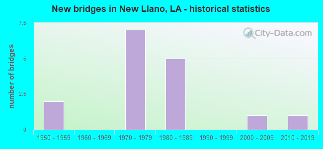
- New bridges - historical statistics
- 21950-1959
- 71970-1979
- 51980-1989
- 12000-2009
- 12010-2019


- Bridge Condition - Deck
- 15.4%Very good
- 61.5%Good
- 23.1%Satisfactory

- Bridge Condition - Superstructure
- 15.4%Very good
- 69.2%Good
- 7.7%Satisfactory
- 7.7%Fair

- Bridge Condition - Substructure
- 7.7%Very good
- 61.5%Good
- 23.1%Satisfactory
- 7.7%Fair

- Bridge Condition - Channel
- 12.5%Good
- 37.5%Satisfactory
- 37.5%Fair
- 12.5%Poor
Find on map >> Show street view
Structure Number: 85800000080592, Location: 1.1 NORTH OF LA 10 (Lat: 31.043619, Lng: -93.275400), Route carried "on" structure: US 171, Year Built: 2012, Status: Open, Structure Length: 6.71m (22.01ft), Average Daily Traffic: 6,350 (year 2016), Truck Traffic: 15%, Average Future Daily Traffic: 4,140 (year 2036), Design Load: HS 20, Features Intersected: BAYOU ZOURIE
Minimum Vertical Clearance: 30+ m (98+ ft), Kilometerpoint: 18.396, Lanes on structure: 2, Base Highway Network: Yes (Inventory Route: 24-06-1, Subroute: 10), Owner: State Highway Agency, Approaching Roadway Width: 12.2m (40.0ft), Skew: 30 degrees, Material/Design: Prestressed concrete continuous, Design/Construction: Stringer/Multi-beam, Number Of Spans In Main Unit: 4, Length of Maximum Span: 16.8m (55.1ft), Curb-To-Curb Width: 12.0m (39.4ft), Out-to-Out Width: 12.6m (41.3ft)
Condition: Deck: Very good, Superstructure: Very good, Substructure: Very good, Channel: Satisfactory, Operating Rating: 63.5 metric tons, Method Used To Determine Operating Rating: Load and Resistance Factor Rating (LRFR) rating reported by rating factor(RF) method using HL-93 loadings, Inventory Rating: 42.1 metric tons, Method Used To Determine Inventory Rating: Load and Resistance Factor Rating (LRFR) rating reported by rating factor(RF) method using HL-93 loadings, Structural Evaluation: Equal to present desirable criteria, Deck Geometry: Better than present minimum criteria, Waterway Adequacy: Better than present minimum criteria, Approach Roadway Alignment: Equal to present desirable criteria, Designated Inspection Frequency: Every 24 months, Inspection Date: Febuary 2020, Deck Structure Type: Concrete Cast-file-Place, Wearing Surface/Protective System: Wearing Surface: Monolithic Concrete
Find on map >> Show street view
Structure Number: 85800240611552, Location: 1.1 MI NORTH OF LA 10 (Lat: 31.043481, Lng: -93.275819), Route carried "on" structure: US 171, Year Built: 1978, Status: Open, Structure Length: 6.92m (22.70ft), Average Daily Traffic: 6,350 (year 2016), Truck Traffic: 15%, Average Future Daily Traffic: 4,140 (year 2036), Design Load: HS 20, Features Intersected: BAYOU ZOURIE
Minimum Vertical Clearance: 30+ m (98+ ft), Kilometerpoint: 11.193, Lanes on structure: 2, Base Highway Network: Yes (Inventory Route: 24-06-2, Subroute: 10), Owner: State Highway Agency, Approaching Roadway Width: 12.2m (40.0ft), Skew: 30 degrees, Material/Design: Prestressed concrete, Design/Construction: Stringer/Multi-beam, Number Of Spans In Main Unit: 5, Length of Maximum Span: 13.7m (44.9ft), Curb-To-Curb Width: 12.0m (39.4ft), Out-to-Out Width: 13.0m (42.7ft)
Condition: Deck: Satisfactory, Superstructure: Very good, Substructure: Good, Channel: Satisfactory, Operating Rating: 69.8 metric tons, Method Used To Determine Operating Rating: Load Factor (LF), Inventory Rating: 41.7 metric tons, Method Used To Determine Inventory Rating: Load Factor (LF), Structural Evaluation: Better than present minimum criteria, Deck Geometry: Better than present minimum criteria, Waterway Adequacy: Better than present minimum criteria, Approach Roadway Alignment: Equal to present desirable criteria, Designated Inspection Frequency: Every 24 months, Inspection Date: Febuary 2020, Deck Structure Type: Concrete Cast-file-Place, Wearing Surface/Protective System: Wearing Surface: Monolithic Concrete
Find on map >> Show street view
Structure Number: 85800240615501, Location: 5.1 MI NORTH OF LA 10 (Lat: 31.103531, Lng: -93.269700), Route carried "on" structure: US 171, Year Built: 1975, Status: Open, Structure Length: 6.13m (20.11ft), Average Daily Traffic: 11,450 (year 2016), Truck Traffic: 15%, Average Future Daily Traffic: 9,108 (year 2036), Design Load: HS 20, Features Intersected: CASTOR CREEK RELIEF
Minimum Vertical Clearance: 30+ m (98+ ft), Kilometerpoint: 25.128, Lanes on structure: 2, Base Highway Network: Yes (Inventory Route: 24-06-1, Subroute: 10), Owner: State Highway Agency, Approaching Roadway Width: 11.6m (38.1ft), Skew: 30 degrees, Material/Design: Concrete, Design/Construction: Slab, Number Of Spans In Main Unit: 10, Length of Maximum Span: 6.1m (20.0ft), Curb-To-Curb Width: 11.7m (38.4ft), Out-to-Out Width: 13.0m (42.7ft)
Condition: Deck: Good, Superstructure: Good, Substructure: Satisfactory, Channel: Good, Operating Rating: 71.7 metric tons, Method Used To Determine Operating Rating: Load Factor (LF), Inventory Rating: 43.5 metric tons, Method Used To Determine Inventory Rating: Load Factor (LF), Structural Evaluation: Equal to present minimum criteria, Deck Geometry: Better than present minimum criteria, Waterway Adequacy: Superior to present desirable criteria, Approach Roadway Alignment: Equal to present desirable criteria, Designated Inspection Frequency: Every 24 months, Underwater Inspection Frequency: Every 60 months, Inspection Date: Febuary 2020, Underwater Inspection Date: April 2018, Deck Structure Type: Concrete Cast-file-Place, Wearing Surface/Protective System: Wearing Surface: Monolithic Concrete
Find on map >> Show street view
Structure Number: 85800240615502, Location: 5.1 MI NORTH OF LA 10 (Lat: 31.103350, Lng: -93.269950), Route carried "on" structure: US 171, Year Built: 1975, Status: Open, Structure Length: 6.13m (20.11ft), Average Daily Traffic: 11,450 (year 2016), Truck Traffic: 15%, Average Future Daily Traffic: 9,108 (year 2036), Design Load: HS 20, Features Intersected: CASTOR CREEK RELIEF
Minimum Vertical Clearance: 30+ m (98+ ft), Kilometerpoint: 4.474, Lanes on structure: 2, Base Highway Network: Yes (Inventory Route: 24-06-2, Subroute: 10), Owner: State Highway Agency, Approaching Roadway Width: 11.6m (38.1ft), Skew: 30 degrees, Material/Design: Concrete, Design/Construction: Slab, Number Of Spans In Main Unit: 10, Length of Maximum Span: 6.1m (20.0ft), Curb-To-Curb Width: 11.7m (38.4ft), Out-to-Out Width: 13.0m (42.7ft)
Condition: Deck: Good, Superstructure: Good, Substructure: Satisfactory, Channel: Good, Operating Rating: 71.7 metric tons, Method Used To Determine Operating Rating: Load Factor (LF), Inventory Rating: 43.5 metric tons, Method Used To Determine Inventory Rating: Load Factor (LF), Structural Evaluation: Equal to present minimum criteria, Deck Geometry: Better than present minimum criteria, Waterway Adequacy: Superior to present desirable criteria, Approach Roadway Alignment: Equal to present desirable criteria, Designated Inspection Frequency: Every 24 months, Underwater Inspection Frequency: Every 60 months, Inspection Date: Febuary 2020, Underwater Inspection Date: April 2018, Deck Structure Type: Other, Wearing Surface/Protective System: Wearing Surface: Monolithic Concrete
Find on map >> Show street view
Structure Number: 85800240615801, Location: 5.4 MI NORTH OF LA 10 (Lat: 31.107419, Lng: -93.270500), Route carried "on" structure: US 171, Year Built: 1975, Status: Open, Structure Length: 7.38m (24.21ft), Average Daily Traffic: 11,450 (year 2016), Truck Traffic: 15%, Average Future Daily Traffic: 9,108 (year 2036), Design Load: HS 20, Features Intersected: CASTOR BAYOU
Minimum Vertical Clearance: 30+ m (98+ ft), Kilometerpoint: 25.568, Lanes on structure: 2, Base Highway Network: Yes (Inventory Route: 24-06-1, Subroute: 10), Owner: State Highway Agency, Approaching Roadway Width: 11.6m (38.1ft), Skew: 30 degrees, Material/Design: Concrete, Design/Construction: Slab, Number Of Spans In Main Unit: 12, Length of Maximum Span: 6.1m (20.0ft), Curb-To-Curb Width: 12.1m (39.7ft), Out-to-Out Width: 13.0m (42.7ft)
Condition: Deck: Good, Superstructure: Good, Substructure: Good, Channel: Fair, Operating Rating: 71.7 metric tons, Method Used To Determine Operating Rating: Load Factor (LF), Inventory Rating: 43.5 metric tons, Method Used To Determine Inventory Rating: Load Factor (LF), Structural Evaluation: Better than present minimum criteria, Deck Geometry: Better than present minimum criteria, Waterway Adequacy: Superior to present desirable criteria, Approach Roadway Alignment: Equal to present desirable criteria, Designated Inspection Frequency: Every 24 months, Inspection Date: Febuary 2020, Deck Structure Type: Concrete Cast-file-Place, Wearing Surface/Protective System: Wearing Surface: Monolithic Concrete
Find on map >> Show street view
Structure Number: 85800240615802, Location: 5.4 MI NORTH OF LA 10 (Lat: 31.107311, Lng: -93.270811), Route carried "on" structure: US 171, Year Built: 1975, Status: Open, Structure Length: 7.38m (24.21ft), Average Daily Traffic: 11,450 (year 2016), Truck Traffic: 15%, Average Future Daily Traffic: 9,108 (year 2036), Design Load: HS 20, Features Intersected: CASTOR BAYOU
Minimum Vertical Clearance: 30+ m (98+ ft), Kilometerpoint: 4.014, Lanes on structure: 2, Base Highway Network: Yes (Inventory Route: 24-06-2, Subroute: 10), Owner: State Highway Agency, Approaching Roadway Width: 11.6m (38.1ft), Skew: 30 degrees, Material/Design: Concrete, Design/Construction: Slab, Number Of Spans In Main Unit: 12, Length of Maximum Span: 6.1m (20.0ft), Curb-To-Curb Width: 12.2m (40.0ft), Out-to-Out Width: 13.0m (42.7ft)
Condition: Deck: Good, Superstructure: Good, Substructure: Good, Channel: Fair, Operating Rating: 71.7 metric tons, Method Used To Determine Operating Rating: Load Factor (LF), Inventory Rating: 43.5 metric tons, Method Used To Determine Inventory Rating: Load Factor (LF), Structural Evaluation: Better than present minimum criteria, Deck Geometry: Better than present minimum criteria, Waterway Adequacy: Superior to present desirable criteria, Approach Roadway Alignment: Equal to present desirable criteria, Designated Inspection Frequency: Every 24 months, Inspection Date: Febuary 2020, Deck Structure Type: Concrete Cast-file-Place, Wearing Surface/Protective System: Wearing Surface: Monolithic Concrete
Find on map >> Show street view
Structure Number: 85800240616401, Location: .25 MI NORTH OF LA 1211 (Lat: 31.116581, Lng: -93.270700), Route carried "on" structure: US 171, Year Built: 1975, Status: Open, Structure Length: 5.52m (18.11ft), Average Daily Traffic: 11,450 (year 2016), Truck Traffic: 14%, Average Future Daily Traffic: 9,108 (year 2036), Design Load: HS 20, Features Intersected: SALES BRANCH
Minimum Vertical Clearance: 30+ m (98+ ft), Kilometerpoint: 26.612, Lanes on structure: 2, Base Highway Network: Yes (Inventory Route: 24-06-1, Subroute: 10), Owner: State Highway Agency, Approaching Roadway Width: 11.6m (38.1ft), Skew: 30 degrees, Material/Design: Concrete, Design/Construction: Slab, Number Of Spans In Main Unit: 9, Length of Maximum Span: 6.1m (20.0ft), Curb-To-Curb Width: 12.1m (39.7ft), Out-to-Out Width: 13.0m (42.7ft)
Condition: Deck: Satisfactory, Superstructure: Good, Substructure: Good, Channel: Fair, Operating Rating: 71.7 metric tons, Method Used To Determine Operating Rating: Load Factor (LF), Inventory Rating: 43.5 metric tons, Method Used To Determine Inventory Rating: Load Factor (LF), Structural Evaluation: Better than present minimum criteria, Deck Geometry: Better than present minimum criteria, Waterway Adequacy: Superior to present desirable criteria, Approach Roadway Alignment: Equal to present desirable criteria, Designated Inspection Frequency: Every 24 months, Inspection Date: Febuary 2020, Deck Structure Type: Concrete Cast-file-Place, Wearing Surface/Protective System: Wearing Surface: Monolithic Concrete
Find on map >> Show street view
Structure Number: 85800240616402, Location: .25 MI NORTH OF LA 1211 (Lat: 31.116650, Lng: -93.270900), Route carried "on" structure: US 171, Year Built: 1975, Status: Open, Structure Length: 5.49m (18.01ft), Average Daily Traffic: 11,450 (year 2016), Truck Traffic: 14%, Average Future Daily Traffic: 9,108 (year 2036), Design Load: HS 20, Features Intersected: SALES BRANCH
Minimum Vertical Clearance: 30+ m (98+ ft), Kilometerpoint: 2.969, Lanes on structure: 2, Base Highway Network: Yes (Inventory Route: 24-06-2, Subroute: 10), Owner: State Highway Agency, Approaching Roadway Width: 11.6m (38.1ft), Skew: 30 degrees, Material/Design: Concrete, Design/Construction: Slab, Number Of Spans In Main Unit: 9, Length of Maximum Span: 6.1m (20.0ft), Curb-To-Curb Width: 11.7m (38.4ft), Out-to-Out Width: 13.0m (42.7ft)
Condition: Deck: Satisfactory, Superstructure: Satisfactory, Substructure: Good, Channel: Satisfactory, Operating Rating: 71.7 metric tons, Method Used To Determine Operating Rating: Load Factor (LF), Inventory Rating: 43.5 metric tons, Method Used To Determine Inventory Rating: Load Factor (LF), Structural Evaluation: Equal to present minimum criteria, Deck Geometry: Better than present minimum criteria, Waterway Adequacy: Better than present minimum criteria, Approach Roadway Alignment: Equal to present desirable criteria, Designated Inspection Frequency: Every 24 months, Inspection Date: Febuary 2020, Deck Structure Type: Concrete Cast-file-Place, Wearing Surface/Protective System: Wearing Surface: Monolithic Concrete
Find on map >> Show street view
Structure Number: 85808580504311, Location: 4.31 MILES WEST OF US 171 (Lat: 31.072431, Lng: -93.317600), Route carried "on" structure: State highway 1211, Year Built: 1958, Status: Open, Structure Length: 3.69m (12.11ft), Average Daily Traffic: 2,100 (year 2016), Truck Traffic: 14%, Average Future Daily Traffic: 1,260 (year 2036), Design Load: H 15, Features Intersected: MILL CREEK
Minimum Vertical Clearance: 30+ m (98+ ft), Kilometerpoint: 6.914, Lanes on structure: 2, Owner: State Highway Agency, Approaching Roadway Width: 7.9m (25.9ft), Skew: 30 degrees, Material/Design: Concrete, Design/Construction: Slab, Number Of Spans In Main Unit: 6, Length of Maximum Span: 6.1m (20.0ft), Curb-To-Curb Width: 7.3m (24.0ft), Out-to-Out Width: 9.0m (29.5ft)
Condition: Deck: Good, Superstructure: Good, Substructure: Satisfactory, Channel: Poor, Operating Rating: 39.0 metric tons, Method Used To Determine Operating Rating: Load Factor (LF), Inventory Rating: 23.6 metric tons, Method Used To Determine Inventory Rating: Load Factor (LF), Structural Evaluation: Equal to present minimum criteria, Deck Geometry: High priority of replacement, Waterway Adequacy: Equal to present desirable criteria, Approach Roadway Alignment: Better than present minimum criteria, Length Of Structure Improvement: 4.60m (15.09ft), Designated Inspection Frequency: Every 24 months, Inspection Date: Febuary 2020, Bridge Improvement Cost: $392,000, Total Project Cost: $588,000 ( Estimate for 2016), Deck Structure Type: Concrete Cast-file-Place, Wearing Surface/Protective System: Wearing Surface: Monolithic Concrete
Find on map >> Show street view
Structure Number: 85808580504731, Location: 4.73 MILES WEST OF US 171 (Lat: 31.070661, Lng: -93.323900), Route carried "on" structure: State highway 1211, Year Built: 1958, Status: Open, Structure Length: 0.67m (2.20ft), Average Daily Traffic: 2,100 (year 2016), Truck Traffic: 14%, Average Future Daily Traffic: 1,260 (year 2036), Design Load: H 15, Features Intersected: CREEK
Minimum Vertical Clearance: 30+ m (98+ ft), Kilometerpoint: 7.588, Lanes on structure: 2, Owner: State Highway Agency, Approaching Roadway Width: 7.9m (25.9ft), Skew: 30 degrees, Material/Design: Concrete, Design/Construction: Culvert, Number Of Spans In Main Unit: 3, Length of Maximum Span: 2.1m (6.9ft)
Condition: Channel: Satisfactory, Culverts: Satisfactory, Operating Rating: 42.1 metric tons, Method Used To Determine Operating Rating: Load and Resistance Factor Rating (LRFR) rating reported by rating factor(RF) method using HL-93 loadings, Inventory Rating: 32.4 metric tons, Method Used To Determine Inventory Rating: Load and Resistance Factor Rating (LRFR) rating reported by rating factor(RF) method using HL-93 loadings, Structural Evaluation: Equal to present minimum criteria, Waterway Adequacy: Equal to present desirable criteria, Approach Roadway Alignment: Equal to present desirable criteria, Designated Inspection Frequency: Every 24 months, Inspection Date: Febuary 2020, Deck Structure Type: Concrete Cast-file-Place
Find on map >> Show street view
Structure Number: 85831022931711, Location: COOPER ROAD (Lat: 31.036531, Lng: -93.285500), Route carried "on" structure: County highway , Year Built: 1983, Status: Open, Structure Length: 4.66m (15.29ft), Average Daily Traffic: 510 (year 1976), Average Future Daily Traffic: 306 (year 2036), Design Load: HS 20, Features Intersected: PARISH RD #4,ZOURIE BAYO, Facility Carried by Structure: COOPER CHURCH RD
Minimum Vertical Clearance: 30+ m (98+ ft), Kilometerpoint: 6.722, Lanes on structure: 2, Owner: County Highway Agency, Approaching Roadway Width: 9.8m (32.2ft), Skew: 30 degrees, Material/Design: Concrete, Design/Construction: Slab, Number Of Spans In Main Unit: 8, Length of Maximum Span: 5.8m (19.0ft), Curb-To-Curb Width: 9.8m (32.2ft), Out-to-Out Width: 10.6m (34.8ft)
Condition: Deck: Good, Superstructure: Good, Substructure: Good, Channel: Fair, Operating Rating: 37.3 metric tons, Method Used To Determine Operating Rating: Load and Resistance Factor Rating (LRFR) rating reported by rating factor(RF) method using HL-93 loadings, Inventory Rating: 28.8 metric tons, Method Used To Determine Inventory Rating: Load and Resistance Factor Rating (LRFR) rating reported by rating factor(RF) method using HL-93 loadings, Structural Evaluation: Better than present minimum criteria, Deck Geometry: Equal to present minimum criteria, Waterway Adequacy: Equal to present desirable criteria, Approach Roadway Alignment: Equal to present desirable criteria, Designated Inspection Frequency: Every 24 months, Inspection Date: March 2021, Deck Structure Type: Concrete Precast Panels, Wearing Surface/Protective System: Wearing Surface: Bituminous
Find on map >> Show street view
Structure Number: 85831022931781, Location: 1.48 M. W. OF US 171 (Lat: 31.036411, Lng: -93.297300), Route carried "on" structure: County highway , Year Built: 2002, Status: Open, Structure Length: 2.99m (9.81ft), Average Daily Traffic: 800 (year 2001), Average Future Daily Traffic: 480 (year 2036), Design Load: HS 20, Features Intersected: ZOURIE CREEK, Facility Carried by Structure: COOPER CHURCH RD
Minimum Vertical Clearance: 30+ m (98+ ft), Kilometerpoint: 5.589, Lanes on structure: 2, Owner: County Highway Agency, Approaching Roadway Width: 9.4m (30.8ft), Skew: 4 degrees, Material/Design: Concrete, Design/Construction: Slab, Number Of Spans In Main Unit: 5, Length of Maximum Span: 5.8m (19.0ft), Curb-To-Curb Width: 8.3m (27.2ft), Out-to-Out Width: 9.3m (30.5ft)
Condition: Deck: Good, Superstructure: Good, Substructure: Good, Channel: Satisfactory, Operating Rating: 42.8 metric tons, Method Used To Determine Operating Rating: Load and Resistance Factor Rating (LRFR) rating reported by rating factor(RF) method using HL-93 loadings, Inventory Rating: 33.0 metric tons, Method Used To Determine Inventory Rating: Load and Resistance Factor Rating (LRFR) rating reported by rating factor(RF) method using HL-93 loadings, Structural Evaluation: Better than present minimum criteria, Deck Geometry: Somewhat better than minimum adequacy, Waterway Adequacy: Superior to present desirable criteria, Approach Roadway Alignment: Better than present minimum criteria, Designated Inspection Frequency: Every 24 months, Inspection Date: March 2021, Deck Structure Type: Concrete Cast-file-Place, Wearing Surface/Protective System: Wearing Surface: Monolithic Concrete
Find on map >> Show street view
Structure Number: 85831034932011, Location: 1.02 M. S. OF END LA 1211 (Lat: 31.057511, Lng: -93.335300), Route carried "on" structure: County highway , Year Built: 1984, Status: Open, Structure Length: 1.25m (4.10ft), Average Daily Traffic: 290 (year 1976), Average Future Daily Traffic: 174 (year 2036), Design Load: HS 20, Features Intersected: BIG BRANCH, Facility Carried by Structure: SAVAGE FORKS RD
Minimum Vertical Clearance: 30+ m (98+ ft), Kilometerpoint: 12.196, Lanes on structure: 2, Owner: County Highway Agency, Approaching Roadway Width: 8.5m (27.9ft), Skew: 37 degrees, Material/Design: Steel, Design/Construction: Culvert, Number Of Spans In Main Unit: 5, Length of Maximum Span: 2.1m (6.9ft)
Condition: Channel: Poor, Culverts: Satisfactory, Operating Rating: 97.2 metric tons, Method Used To Determine Operating Rating: Load and Resistance Factor Rating (LRFR) rating reported by rating factor(RF) method using HL-93 loadings, Inventory Rating: 74.5 metric tons, Method Used To Determine Inventory Rating: Load and Resistance Factor Rating (LRFR) rating reported by rating factor(RF) method using HL-93 loadings, Structural Evaluation: Equal to present minimum criteria, Waterway Adequacy: Equal to present desirable criteria, Approach Roadway Alignment: Equal to present desirable criteria, Designated Inspection Frequency: Every 24 months, Inspection Date: March 2021
Find on map >> Show street view
Structure Number: 85831035932001, Location: 1.0 M. S. OF END LA 1211 (Lat: 31.058289, Lng: -93.334500), Route carried "on" structure: County highway , Year Built: 1984, Status: Open, Structure Length: 2.32m (7.61ft), Average Daily Traffic: 290 (year 1976), Average Future Daily Traffic: 174 (year 2036), Design Load: HS 20, Features Intersected: BIG BRANCH, Facility Carried by Structure: SAVAGE FORKS RD
Minimum Vertical Clearance: 30+ m (98+ ft), Kilometerpoint: 12.307, Lanes on structure: 2, Owner: County Highway Agency, Approaching Roadway Width: 9.1m (29.9ft), Skew: 31 degrees, Material/Design: Concrete, Design/Construction: Slab, Number Of Spans In Main Unit: 4, Length of Maximum Span: 5.8m (19.0ft), Curb-To-Curb Width: 8.5m (27.9ft), Out-to-Out Width: 9.4m (30.8ft)
Condition: Deck: Good, Superstructure: Good, Substructure: Good, Channel: Satisfactory, Operating Rating: 36.0 metric tons, Method Used To Determine Operating Rating: Load and Resistance Factor Rating (LRFR) rating reported by rating factor(RF) method using HL-93 loadings, Inventory Rating: 27.9 metric tons, Method Used To Determine Inventory Rating: Load and Resistance Factor Rating (LRFR) rating reported by rating factor(RF) method using HL-93 loadings, Structural Evaluation: Better than present minimum criteria, Deck Geometry: Equal to present minimum criteria, Waterway Adequacy: Equal to present desirable criteria, Approach Roadway Alignment: Equal to present minimum criteria, Designated Inspection Frequency: Every 24 months, Inspection Date: March 2021, Deck Structure Type: Concrete Cast-file-Place, Wearing Surface/Protective System: Wearing Surface: Monolithic Concrete
Find on map >> Show street view
Structure Number: 85831043931811, Location: .77 M. E. OF LA 1211 (Lat: 31.072011, Lng: -93.302000), Route carried "on" structure: County highway , Year Built: 1986, Status: Posted for load, Structure Length: 2.93m (9.61ft), Average Daily Traffic: 150 (year 1976), Average Future Daily Traffic: 90 (year 2036), Design Load: H 10, Features Intersected: CASTOR BAYOU, Facility Carried by Structure: SECTION LINE RD
Minimum Vertical Clearance: 30+ m (98+ ft), Kilometerpoint: 2.752, Lanes on structure: 2, Owner: County Highway Agency, Approaching Roadway Width: 9.1m (29.9ft), Skew: 30 degrees, Material/Design: Wood or Timber, Design/Construction: Stringer/Multi-beam, Number Of Spans In Main Unit: 6, Length of Maximum Span: 5.5m (18.0ft), Curb-To-Curb Width: 5.7m (18.7ft), Out-to-Out Width: 6.1m (20.0ft)
Condition: Deck: Very good, Superstructure: Fair, Substructure: Fair, Channel: Fair, Operating Rating: 14.5 metric tons, Method Used To Determine Operating Rating: Allowable Stress (AS), Inventory Rating: 10.9 metric tons, Method Used To Determine Inventory Rating: Allowable Stress (AS), Structural Evaluation: Meets minimum limits, Deck Geometry: High priority of corrective action, Waterway Adequacy: Equal to present desirable criteria, Approach Roadway Alignment: Somewhat better than minimum adequacy, Bridge Posting: Required (Relationship of Operating Rating to Maximum Legal Load: 30.0 - 39.9% below), Length Of Structure Improvement: 3.75m (12.30ft), Designated Inspection Frequency: Every 24 months, Other Special Inspection Frequency: Every 12 months, Inspection Date: March 2021, Other Special Inspection Date: March 2020, Bridge Improvement Cost: $223,000, Total Project Cost: $334,000 ( Estimate for 2016), Deck Structure Type: Wood or Timber, Wearing Surface/Protective System: Wearing Surface: Bituminous
Find on map >> Show street view
Structure Number: 85831050931901, Location: 1.38 M. W. OF LA 1211 (Lat: 31.083131, Lng: -93.316300), Route carried "on" structure: County highway , Year Built: 1987, Status: Open, Structure Length: 1.31m (4.30ft), Average Daily Traffic: 250 (year 1976), Average Future Daily Traffic: 150 (year 2036), Design Load: HS 20, Features Intersected: CASTOR BAYOU TRIBUTARY, Facility Carried by Structure: VFW RD
Minimum Vertical Clearance: 30+ m (98+ ft), Kilometerpoint: 0.595, Lanes on structure: 2, Owner: County Highway Agency, Approaching Roadway Width: 7.3m (24.0ft), Skew: 30 degrees, Material/Design: Steel, Design/Construction: Culvert, Number Of Spans In Main Unit: 3, Length of Maximum Span: 3.4m (11.2ft)
Condition: Channel: Fair, Culverts: Satisfactory, Operating Rating: 97.2 metric tons, Method Used To Determine Operating Rating: Load and Resistance Factor Rating (LRFR) rating reported by rating factor(RF) method using HL-93 loadings, Inventory Rating: 74.5 metric tons, Method Used To Determine Inventory Rating: Load and Resistance Factor Rating (LRFR) rating reported by rating factor(RF) method using HL-93 loadings, Structural Evaluation: Equal to present minimum criteria, Waterway Adequacy: Equal to present desirable criteria, Approach Roadway Alignment: Equal to present desirable criteria, Designated Inspection Frequency: Every 24 months, Inspection Date: March 2021