Bridge Statistics for New London, Wisconsin (WI)
Condition, Traffic, Stress, Structural Evaluation, Project Costs
- National Bridge Inventory (NBI) Statistics
- 16Number of bridges
- 269ft / 82.2mTotal length
- $2,200,000Total costs
- 94,646Total average daily traffic
- 1,698Total average daily truck traffic
- National Bridge Inventory (NBI) Registered Bridges for New London
- No street view available for this location
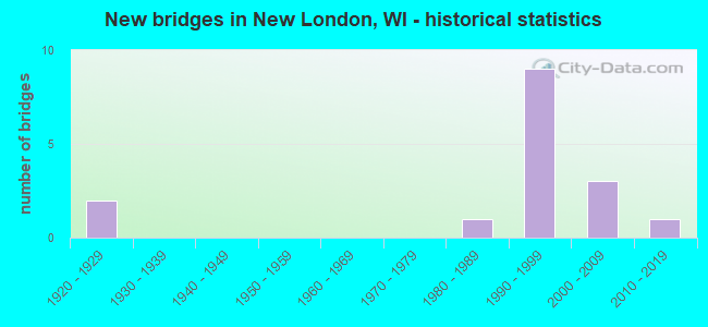
- New bridges - historical statistics
- 21920-1929
- 11980-1989
- 91990-1999
- 32000-2009
- 12010-2019


- Bridge Condition - Deck
- 78.6%Good
- 7.1%Satisfactory
- 14.3%Fair

- Bridge Condition - Superstructure
- 14.3%Very good
- 57.1%Good
- 14.3%Satisfactory
- 7.1%Fair
- 7.1%Poor

- Bridge Condition - Substructure
- 92.9%Good
- 7.1%Fair

- Bridge Condition - Channel
- 77.8%Very good
- 22.2%Good
Find on map >> Show street view
Structure Number: B440118, Location: 0.3M N JCT STH 54 (Lat: 44.417083, Lng: -88.698550), Route carried "on" structure: City street , Year Built: 1987, Status: Open, Structure Length: 2.49m (8.17ft), Average Daily Traffic: 171 (year 2019), Average Future Daily Traffic: 188 (year 2040), Design Load: HS 20, Features Intersected: EMBARASS RIVER, Facility Carried by Structure: LRD SPURR RD
Minimum Vertical Clearance: 30+ m (98+ ft), Kilometerpoint: 0.000, Lanes on structure: 2, Owner: Town or Township Highway Agency, Approaching Roadway Width: 7.9m (25.9ft), Material/Design: Concrete continuous, Design/Construction: Slab, Number Of Spans In Main Unit: 2, Length of Maximum Span: 12.2m (40.0ft), Curb-To-Curb Width: 7.3m (24.0ft), Out-to-Out Width: 7.9m (25.9ft)
Condition: Deck: Satisfactory, Superstructure: Satisfactory, Substructure: Good, Channel: Good, Operating Rating: 58.8 metric tons, Method Used To Determine Operating Rating: Load Factor (LF), Inventory Rating: 34.0 metric tons, Method Used To Determine Inventory Rating: Load Factor (LF), Structural Evaluation: Equal to present minimum criteria, Deck Geometry: Somewhat better than minimum adequacy, Waterway Adequacy: Equal to present desirable criteria, Approach Roadway Alignment: Equal to present desirable criteria, Designated Inspection Frequency: Every 24 months, Underwater Inspection Frequency: Every 72 months, Inspection Date: November 2021, Underwater Inspection Date: July 2017, Deck Structure Type: Concrete Cast-file-Place, Wearing Surface/Protective System: Wearing Surface: Monolithic Concrete, Deck Protection: Epoxy Coated Reinforcing
Find on map >> Show street view
Structure Number: B44014, Location: AT IH 41 (Lat: 44.298889, Lng: -88.445767), Route carried "on" structure: County highway , Year Built: 2005, Status: Open, Structure Length: 6.52m (21.39ft), Average Daily Traffic: 11,000 (year 2021), Average Future Daily Traffic: 23,620 (year 2040), Design Load: HS 20, Features Intersected: IH 41, Facility Carried by Structure: CTH A
Minimum Vertical Clearance: 30+ m (98+ ft), Kilometerpoint: 0.000, Lanes on structure: 4, Lanes under structure: 4, Owner: State Highway Agency, Approaching Roadway Width: 20.7m (67.9ft), Skew: 20 degrees, Material/Design: Prestressed concrete continuous, Design/Construction: Stringer/Multi-beam, Number Of Spans In Main Unit: 2, Length of Maximum Span: 32.9m (107.9ft), Curb or Sidewalk Widths: Left: 2.0m (6.6ft), Right: 3.7m (12.1ft), Curb-To-Curb Width: 18.9m (62.0ft), Out-to-Out Width: 27.4m (89.9ft)
Condition: Deck: Good, Superstructure: Very good, Substructure: Good, Operating Rating: 73.0 metric tons, Method Used To Determine Operating Rating: Load Factor (LF), Inventory Rating: 34.0 metric tons, Method Used To Determine Inventory Rating: Load Factor (LF), Structural Evaluation: Better than present minimum criteria, Deck Geometry: Equal to present minimum criteria, Underclear: Somewhat better than minimum adequacy, Approach Roadway Alignment: Equal to present desirable criteria, Designated Inspection Frequency: Every 48 months, Inspection Date: July 2021, Deck Structure Type: Concrete Cast-file-Place, Wearing Surface/Protective System: Wearing Surface: Monolithic Concrete, Deck Protection: Epoxy Coated Reinforcing
Find on map >> Show street view
Structure Number: B440141, Location: 7.7M N JCT CTH M (Lat: 44.400178, Lng: -88.731433), Route carried "on" structure: US 45, Year Built: 1994, Status: Open, Structure Length: 4.19m (13.75ft), Average Daily Traffic: 8,900 (year 2018), Truck Traffic: 3%, Average Future Daily Traffic: 10,630 (year 2040), Design Load: HS 20, Features Intersected: GREEN BAY & WESTERN RR
Minimum Vertical Clearance: 30+ m (98+ ft), Kilometerpoint: 0.000, Lanes on structure: 2, Base Highway Network: Yes, Owner: State Highway Agency, Approaching Roadway Width: 13.4m (44.0ft), Skew: 1 degrees, Material/Design: Prestressed concrete, Design/Construction: Stringer/Multi-beam, Number Of Spans In Main Unit: 1, Length of Maximum Span: 40.8m (133.9ft), Curb-To-Curb Width: 13.4m (44.0ft), Out-to-Out Width: 14.3m (46.9ft)
Condition: Deck: Good, Superstructure: Good, Substructure: Good, Inventory Rating: 47.0 metric tons, Method Used To Determine Inventory Rating: Load Factor (LF), Structural Evaluation: Better than present minimum criteria, Deck Geometry: Equal to present minimum criteria, Underclear: Better than present minimum criteria, Approach Roadway Alignment: Equal to present desirable criteria, Designated Inspection Frequency: Every 48 months, Inspection Date: April 2021, Deck Structure Type: Concrete Cast-file-Place, Wearing Surface/Protective System: Wearing Surface: Epoxy Overlay, Deck Protection: Epoxy Coated Reinforcing
Find on map >> Show street view
Structure Number: B440142, Location: 7.7M N JCT CTH M (Lat: 44.400469, Lng: -88.730542), Route carried "on" structure: State highway 217, Year Built: 1994, Status: Open, Structure Length: 4.33m (14.21ft), Average Daily Traffic: 2,000 (year 2019), Truck Traffic: 5%, Average Future Daily Traffic: 2,220 (year 2038), Design Load: HS 20, Features Intersected: GREEN BAY & W RR, Facility Carried by Structure: STH 45NB RAMP TO S
Minimum Vertical Clearance: 30+ m (98+ ft), Kilometerpoint: 0.000, Lanes on structure: 1, Owner: State Highway Agency, Approaching Roadway Width: 8.2m (26.9ft), Skew: 2 degrees, Material/Design: Prestressed concrete continuous, Design/Construction: Stringer/Multi-beam, Number Of Spans In Main Unit: 3, Length of Maximum Span: 14.2m (46.6ft), Curb-To-Curb Width: 8.2m (26.9ft), Out-to-Out Width: 9.1m (29.9ft)
Condition: Deck: Good, Superstructure: Good, Substructure: Good, Operating Rating: 50.6 metric tons, Method Used To Determine Operating Rating: Load Factor (LF), Inventory Rating: 30.8 metric tons, Method Used To Determine Inventory Rating: Load Factor (LF), Structural Evaluation: Better than present minimum criteria, Deck Geometry: Meets minimum limits, Underclear: Equal to present minimum criteria, Approach Roadway Alignment: Equal to present desirable criteria, Designated Inspection Frequency: Every 48 months, Inspection Date: April 2019, Deck Structure Type: Concrete Cast-file-Place, Wearing Surface/Protective System: Wearing Surface: Monolithic Concrete, Deck Protection: Epoxy Coated Reinforcing
Find on map >> Show street view
Structure Number: B440144, Location: 8.0M N JCT CTH M (Lat: 44.402781, Lng: -88.733819), Route carried "on" structure: US 45, Year Built: 1994, Status: Open, Structure Length: 16.42m (53.87ft), Average Daily Traffic: 7,200 (year 2019), Truck Traffic: 3%, Average Future Daily Traffic: 9,480 (year 2040), Design Load: HS 20, Features Intersected: STH 54-EMBARRASS RIVER
Minimum Vertical Clearance: 30+ m (98+ ft), Kilometerpoint: 0.000, Lanes on structure: 3, Lanes under structure: 4, Base Highway Network: Yes, Owner: State Highway Agency, Approaching Roadway Width: 21.3m (69.9ft), Skew: 2 degrees, Material/Design: Steel continuous, Design/Construction: Stringer/Multi-beam, Number Of Spans In Main Unit: 5, Length of Maximum Span: 39.6m (129.9ft), Curb-To-Curb Width: 21.9m (71.9ft), Out-to-Out Width: 22.8m (74.8ft)
Condition: Deck: Good, Superstructure: Good, Substructure: Good, Channel: Very good, Operating Rating: 73.0 metric tons, Method Used To Determine Operating Rating: Load Factor (LF), Inventory Rating: 43.7 metric tons, Method Used To Determine Inventory Rating: Load Factor (LF), Structural Evaluation: Better than present minimum criteria, Deck Geometry: Superior to present desirable criteria, Underclear: Equal to present minimum criteria, Waterway Adequacy: Equal to present desirable criteria, Approach Roadway Alignment: Equal to present desirable criteria, Designated Inspection Frequency: Every 48 months, Inspection Date: April 2021, Deck Structure Type: Concrete Cast-file-Place, Wearing Surface/Protective System: Wearing Surface: Epoxy Overlay, Deck Protection: Epoxy Coated Reinforcing
Find on map >> Show street view
Structure Number: B440146, Location: 5.2M W JCT CTH M (Lat: 44.403106, Lng: -88.734961), Route carried "on" structure: State highway 54, Year Built: 1993, Status: Open, Structure Length: 8.05m (26.41ft), Average Daily Traffic: 3,900 (year 2019), Average Future Daily Traffic: 10,250 (year 2040), Design Load: HS 20, Features Intersected: EMBARRASS RIVER
Minimum Vertical Clearance: 30+ m (98+ ft), Kilometerpoint: 0.000, Lanes on structure: 2, Owner: State Highway Agency, Approaching Roadway Width: 11.0m (36.1ft), Skew: 23 degrees, Material/Design: Prestressed concrete continuous, Design/Construction: Stringer/Multi-beam, Number Of Spans In Main Unit: 2, Length of Maximum Span: 39.6m (129.9ft), Curb-To-Curb Width: 11.0m (36.1ft), Out-to-Out Width: 13.9m (45.6ft)
Condition: Deck: Good, Superstructure: Very good, Substructure: Good, Channel: Very good, Operating Rating: 60.4 metric tons, Method Used To Determine Operating Rating: Load Factor (LF), Inventory Rating: 35.6 metric tons, Method Used To Determine Inventory Rating: Load Factor (LF), Structural Evaluation: Better than present minimum criteria, Deck Geometry: Equal to present minimum criteria, Waterway Adequacy: Equal to present desirable criteria, Approach Roadway Alignment: Equal to present desirable criteria, Designated Inspection Frequency: Every 48 months, Underwater Inspection Frequency: Every 60 months, Inspection Date: April 2021, Underwater Inspection Date: July 2020, Deck Structure Type: Concrete Cast-file-Place, Wearing Surface/Protective System: Wearing Surface: Monolithic Concrete, Deck Protection: Epoxy Coated Reinforcing
Find on map >> Show street view
Structure Number: B440147, Location: 0.3M E JCT USH 45 (Lat: 44.402839, Lng: -88.736192), Route carried "on" structure: State highway 54, Year Built: 1993, Status: Open, Structure Length: 8.05m (26.41ft), Average Daily Traffic: 4,000 (year 2019), Average Future Daily Traffic: 10,250 (year 2040), Design Load: HS 20, Features Intersected: EMBARRASS RIVER
Minimum Vertical Clearance: 30+ m (98+ ft), Kilometerpoint: 0.000, Lanes on structure: 2, Owner: State Highway Agency, Approaching Roadway Width: 11.0m (36.1ft), Skew: 23 degrees, Material/Design: Prestressed concrete continuous, Design/Construction: Stringer/Multi-beam, Number Of Spans In Main Unit: 2, Length of Maximum Span: 39.6m (129.9ft), Curb-To-Curb Width: 11.0m (36.1ft), Out-to-Out Width: 13.9m (45.6ft)
Condition: Deck: Good, Superstructure: Good, Substructure: Good, Channel: Very good, Operating Rating: 60.4 metric tons, Method Used To Determine Operating Rating: Load Factor (LF), Inventory Rating: 35.6 metric tons, Method Used To Determine Inventory Rating: Load Factor (LF), Structural Evaluation: Better than present minimum criteria, Deck Geometry: Equal to present minimum criteria, Waterway Adequacy: Equal to present desirable criteria, Approach Roadway Alignment: Equal to present desirable criteria, Designated Inspection Frequency: Every 48 months, Underwater Inspection Frequency: Every 60 months, Inspection Date: April 2021, Underwater Inspection Date: July 2020, Deck Structure Type: Concrete Cast-file-Place, Wearing Surface/Protective System: Wearing Surface: Monolithic Concrete, Deck Protection: Epoxy Coated Reinforcing
Find on map >> Show street view
Structure Number: B440149, Location: 7.1M N JCT CTH M (Lat: 44.396025, Lng: -88.727500), Route carried "on" structure: US 45, Year Built: 1994, Status: Open, Structure Length: 3.29m (10.79ft), Average Daily Traffic: 11,500 (year 2019), Truck Traffic: 3%, Average Future Daily Traffic: 10,630 (year 2040), Design Load: HS 20, Features Intersected: LRD N WATER ST
Minimum Vertical Clearance: 30+ m (98+ ft), Kilometerpoint: 0.000, Lanes on structure: 2, Lanes under structure: 2, Base Highway Network: Yes, Owner: State Highway Agency, Approaching Roadway Width: 13.4m (44.0ft), Material/Design: Prestressed concrete continuous, Design/Construction: Stringer/Multi-beam, Number Of Spans In Main Unit: 3, Length of Maximum Span: 19.2m (63.0ft), Curb-To-Curb Width: 13.4m (44.0ft), Out-to-Out Width: 14.3m (46.9ft)
Condition: Deck: Good, Superstructure: Good, Substructure: Good, Operating Rating: 75.1 metric tons, Method Used To Determine Operating Rating: Load Factor (LF), Inventory Rating: 43.7 metric tons, Method Used To Determine Inventory Rating: Load Factor (LF), Structural Evaluation: Better than present minimum criteria, Deck Geometry: Equal to present minimum criteria, Underclear: Equal to present minimum criteria, Approach Roadway Alignment: Equal to present desirable criteria, Designated Inspection Frequency: Every 48 months, Inspection Date: April 2021, Deck Structure Type: Concrete Cast-file-Place, Wearing Surface/Protective System: Wearing Surface: Epoxy Overlay, Deck Protection: Epoxy Coated Reinforcing
Find on map >> Show street view
Structure Number: B680086, Location: 0.1M S JCT USH 45 (Lat: 44.391781, Lng: -88.745311), Route carried "on" structure: County highway , Year Built: 1998, Status: Open, Structure Length: 7.58m (24.87ft), Average Daily Traffic: 9,400 (year 2018), Average Future Daily Traffic: 11,280 (year 2038), Design Load: HS 20, Features Intersected: WOLF RIVER, Facility Carried by Structure: CTH X SHAWANO ST
Minimum Vertical Clearance: 30+ m (98+ ft), Kilometerpoint: 0.000, Lanes on structure: 2, Owner: County Highway Agency, Approaching Roadway Width: 11.3m (37.1ft), Material/Design: Concrete continuous, Design/Construction: Slab, Number Of Spans In Main Unit: 4, Length of Maximum Span: 21.8m (71.5ft), Curb or Sidewalk Widths: Left: 1.8m (5.9ft), Right: 2.0m (6.6ft), Curb-To-Curb Width: 11.0m (36.1ft), Out-to-Out Width: 15.2m (49.9ft)
Condition: Deck: Good, Superstructure: Good, Substructure: Good, Channel: Very good, Operating Rating: 67.0 metric tons, Method Used To Determine Operating Rating: Load Factor (LF), Inventory Rating: 40.5 metric tons, Method Used To Determine Inventory Rating: Load Factor (LF), Structural Evaluation: Better than present minimum criteria, Deck Geometry: Meets minimum limits, Waterway Adequacy: Equal to present desirable criteria, Approach Roadway Alignment: Equal to present desirable criteria, Designated Inspection Frequency: Every 48 months, Underwater Inspection Frequency: Every 60 months, Inspection Date: July 2021, Underwater Inspection Date: July 2021, Deck Structure Type: Concrete Cast-file-Place, Wearing Surface/Protective System: Wearing Surface: Monolithic Concrete
Find on map >> Show street view
Structure Number: B68011, Location: 1.5M E JCT CTH II (Lat: 44.251056, Lng: -88.820256), Route carried "on" structure: US 10, Year Built: 2003, Status: Open, Structure Length: 3.10m (10.17ft), Average Daily Traffic: 8,800 (year 2019), Average Future Daily Traffic: 16,200 (year 2039), Design Load: HS 20, Features Intersected: LRD MARTIN RD
Minimum Vertical Clearance: 30+ m (98+ ft), Kilometerpoint: 0.000, Lanes on structure: 2, Lanes under structure: 2, Base Highway Network: Yes, Owner: State Highway Agency, Approaching Roadway Width: 12.2m (40.0ft), Material/Design: Prestressed concrete, Design/Construction: Stringer/Multi-beam, Number Of Spans In Main Unit: 1, Length of Maximum Span: 29.9m (98.1ft), Curb-To-Curb Width: 12.3m (40.4ft), Out-to-Out Width: 13.2m (43.3ft)
Condition: Deck: Good, Superstructure: Satisfactory, Substructure: Good, Operating Rating: 71.8 metric tons, Method Used To Determine Operating Rating: Load Factor (LF), Inventory Rating: 38.9 metric tons, Method Used To Determine Inventory Rating: Load Factor (LF), Structural Evaluation: Equal to present minimum criteria, Deck Geometry: Better than present minimum criteria, Underclear: Somewhat better than minimum adequacy, Approach Roadway Alignment: Equal to present desirable criteria, Designated Inspection Frequency: Every 24 months, Inspection Date: July 2020, Deck Structure Type: Concrete Cast-file-Place, Wearing Surface/Protective System: Wearing Surface: Monolithic Concrete, Deck Protection: Epoxy Coated Reinforcing
Find on map >> Show street view
Structure Number: B680118, Location: 0.5M N JCT CTH X (Lat: 44.400000, Lng: -88.745000), Route carried "on" structure: County highway , Year Built: 2004, Status: Open, Structure Length: 7.73m (25.36ft), Average Daily Traffic: 10,400 (year 2018), Truck Traffic: 4%, Average Future Daily Traffic: 12,480 (year 2038), Design Load: HS 20, Features Intersected: TR. EMBARRASS RIVER, Facility Carried by Structure: CTH D
Minimum Vertical Clearance: 30+ m (98+ ft), Kilometerpoint: 0.000, Lanes on structure: 4, Base Highway Network: Yes, Owner: County Highway Agency, Approaching Roadway Width: 14.6m (47.9ft), Material/Design: Concrete continuous, Design/Construction: Slab, Number Of Spans In Main Unit: 5, Length of Maximum Span: 17.4m (57.1ft), Curb-To-Curb Width: 14.6m (47.9ft), Out-to-Out Width: 18.7m (61.4ft)
Condition: Deck: Good, Superstructure: Good, Substructure: Good, Channel: Very good, Operating Rating: 73.0 metric tons, Method Used To Determine Operating Rating: Load Factor (LF), Inventory Rating: 43.7 metric tons, Method Used To Determine Inventory Rating: Load Factor (LF), Structural Evaluation: Better than present minimum criteria, Deck Geometry: High priority of replacement, Waterway Adequacy: Equal to present desirable criteria, Approach Roadway Alignment: Equal to present desirable criteria, Length Of Structure Improvement: 8.17m (26.80ft), Designated Inspection Frequency: Every 24 months, Inspection Date: May 2021, Bridge Improvement Cost: $1,304,000, Roadway Improvement Cost: $130,000, Total Project Cost: $1,957,000 ( Estimate for 2021), Deck Structure Type: Concrete Cast-file-Place, Wearing Surface/Protective System: Wearing Surface: Monolithic Concrete
Find on map >> Show street view
Structure Number: B680129, Location: 0.1M N JCT CTH X (Lat: 44.391667, Lng: -88.739556), Route carried "on" structure: County highway , Year Built: 2010, Status: Open, Structure Length: 6.43m (21.10ft), Average Daily Traffic: 5,900 (year 2018), Truck Traffic: 6%, Average Future Daily Traffic: 6,980 (year 2038), Design Load: HL 93, Features Intersected: WOLF RIVER, Facility Carried by Structure: CTH D - PEARL ST
Minimum Vertical Clearance: 30+ m (98+ ft), Kilometerpoint: 0.000, Lanes on structure: 2, Base Highway Network: Yes, Owner: County Highway Agency, Approaching Roadway Width: 13.7m (44.9ft), Material/Design: Concrete continuous, Design/Construction: Slab, Number Of Spans In Main Unit: 4, Length of Maximum Span: 20.1m (65.9ft), Curb or Sidewalk Widths: Left: 2.0m (6.6ft), Right: 2.0m (6.6ft), Curb-To-Curb Width: 12.2m (40.0ft), Out-to-Out Width: 16.5m (54.1ft)
Condition: Deck: Good, Superstructure: Good, Substructure: Good, Channel: Very good, Operating Rating: 55.7 metric tons, Method Used To Determine Operating Rating: Load and Resistance Factor Rating (LRFR) rating reported by rating factor(RF) method using HL-93 loadings, Inventory Rating: 42.8 metric tons, Method Used To Determine Inventory Rating: Load and Resistance Factor Rating (LRFR) rating reported by rating factor(RF) method using HL-93 loadings, Structural Evaluation: Better than present minimum criteria, Deck Geometry: Somewhat better than minimum adequacy, Waterway Adequacy: Equal to present desirable criteria, Approach Roadway Alignment: Equal to present desirable criteria, Designated Inspection Frequency: Every 48 months, Underwater Inspection Frequency: Every 60 months, Inspection Date: July 2021, Underwater Inspection Date: July 2021, Deck Structure Type: Concrete Cast-file-Place, Wearing Surface/Protective System: Wearing Surface: Epoxy Overlay
Find on map >> Show street view
Structure Number: P440705, Location: 0.1M S JCT USH 96 (Lat: 44.334317, Lng: -88.641033), Route carried "on" structure: City street , Year Built: 1920, Status: Open, Structure Length: 1.07m (3.51ft), Average Daily Traffic: 940 (year 2019), Average Future Daily Traffic: 1,034 (year 2040), Design Load: HS 20, Features Intersected: BLACK OTTER CREEK, Facility Carried by Structure: LRD MILL ST
Minimum Vertical Clearance: 30+ m (98+ ft), Kilometerpoint: 0.000, Lanes on structure: 2, Owner: City or Municipal Highway Agency, Approaching Roadway Width: 11.3m (37.1ft), Skew: 2 degrees, Material/Design: Concrete, Design/Construction: Stringer/Multi-beam, Number Of Spans In Main Unit: 1, Length of Maximum Span: 9.6m (31.5ft), Curb or Sidewalk Widths: Left: 2.0m (6.6ft), Right: 2.0m (6.6ft), Curb-To-Curb Width: 12.2m (40.0ft), Out-to-Out Width: 16.2m (53.1ft)
Condition: Deck: Fair, Superstructure: Poor, Substructure: Fair, Channel: Very good, Operating Rating: 35.9 metric tons, Method Used To Determine Operating Rating: Load Factor (LF), Inventory Rating: 17.8 metric tons, Method Used To Determine Inventory Rating: Load Factor (LF), Structural Evaluation: Meets minimum limits, Deck Geometry: Equal to present desirable criteria, Waterway Adequacy: Equal to present desirable criteria, Approach Roadway Alignment: Equal to present minimum criteria, Length Of Structure Improvement: 1.52m (4.99ft), Designated Inspection Frequency: Every 12 months, Inspection Date: October 2021, Bridge Improvement Cost: $162,000, Roadway Improvement Cost: $16,000, Total Project Cost: $243,000 ( Estimate for 2021), Deck Structure Type: Concrete Cast-file-Place, Wearing Surface/Protective System: Wearing Surface: Bituminous
Find on map >> Show street view
Structure Number: P440708, Location: 0.2M E JCT S PEARL ST (Lat: 44.393433, Lng: -88.733900), Route carried "on" structure: City street , Year Built: 1920, Year Reconstructed: 1960, Status: Open, Structure Length: 2.99m (9.81ft), Average Daily Traffic: 1,435 (year 2019), Average Future Daily Traffic: 1,578 (year 2040), Design Load: H 15, Features Intersected: EMBARRASS RIVER, Facility Carried by Structure: LRD E. NORTH WATER
Minimum Vertical Clearance: 30+ m (98+ ft), Kilometerpoint: 0.000, Lanes on structure: 2, Owner: City or Municipal Highway Agency, Approaching Roadway Width: 12.2m (40.0ft), Material/Design: Prestressed concrete, Design/Construction: Slab, Number Of Spans In Main Unit: 2, Length of Maximum Span: 13.9m (45.6ft), Curb-To-Curb Width: 9.0m (29.5ft), Out-to-Out Width: 9.1m (29.9ft)
Condition: Deck: Fair, Superstructure: Fair, Substructure: Good, Channel: Good, Operating Rating: 29.4 metric tons, Method Used To Determine Operating Rating: Field evaluation and documented engineering judgment, Inventory Rating: 17.8 metric tons, Method Used To Determine Inventory Rating: Field evaluation and documented engineering judgment, Structural Evaluation: Meets minimum limits, Deck Geometry: Somewhat better than minimum adequacy, Waterway Adequacy: Equal to present desirable criteria, Approach Roadway Alignment: Equal to present desirable criteria, Designated Inspection Frequency: Every 24 months, Inspection Date: November 2021, Deck Structure Type: Concrete Cast-file-Place, Wearing Surface/Protective System: Wearing Surface: Bituminous
Find on map >> Show street view
Structure Number: B440144, Location: 0.4M E JCT USH 45 (Lat: 44.402781, Lng: -88.733819), Route carried "under" structure: State highway 54, Year Built: 1994, Structure Length: 0. m, Average Daily Traffic: 7,300 (year 2019), Features Intersected: STH 54-EMBARRASS RIVER, Facility Carried by Structure: USH 45
Minimum Vertical Clearance: 5.10m (16.73ft), Kilometerpoint: 0.000, Lanes on structure: 3, Lanes under structure: 4, Material/Design: Steel continuous, Design/Construction: Stringer/Multi-beam, Length of Maximum Span: 39.6m (129.9ft)
Find on map >> Show street view
Structure Number: B440149, Location: 0.2M W JCT CTH S (Lat: 44.396025, Lng: -88.727500), Route carried "under" structure: City street , Year Built: 1994, Structure Length: 0. m, Average Daily Traffic: 1,800 (year 2019), Features Intersected: LRD N WATER ST, Facility Carried by Structure: USH 45
Minimum Vertical Clearance: 4.65m (15.26ft), Kilometerpoint: 0.000, Lanes on structure: 2, Lanes under structure: 2, Material/Design: Prestressed concrete continuous, Design/Construction: Stringer/Multi-beam, Length of Maximum Span: 19.2m (63.0ft)