Bridge Statistics for New Madrid, Missouri (MO)
Condition, Traffic, Stress, Structural Evaluation, Project Costs
- National Bridge Inventory (NBI) Statistics
- 14Number of bridges
- 148ft / 44.8mTotal length
- $628,000Total costs
- 107,684Total average daily traffic
- 58,198Total average daily truck traffic
- National Bridge Inventory (NBI) Registered Bridges for New Madrid
- No street view available for this location
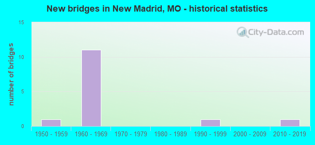
- New bridges - historical statistics
- 11950-1959
- 111960-1969
- 11990-1999
- 12010-2019


- Bridge Condition - Deck
- 25.0%Good
- 25.0%Satisfactory
- 50.0%Fair

- Bridge Condition - Superstructure
- 12.5%Excellent
- 12.5%Very good
- 25.0%Good
- 50.0%Satisfactory

- Bridge Condition - Substructure
- 12.5%Excellent
- 25.0%Good
- 50.0%Satisfactory
- 12.5%Poor

- Bridge Condition - Channel
- 33.3%Very good
- 33.3%Good
- 33.3%Satisfactory
Find on map >> Show street view
Structure Number: 1009, Location: S 9 T 23 N R 14 E (Lat: 36.656608, Lng: -89.538603), Route carried "on" structure: Interstate 55, Year Built: 1964, Status: Open, Structure Length: 6.80m (22.31ft), Average Daily Traffic: 13,678 (year 2021), Truck Traffic: 58%, Average Future Daily Traffic: 25,304 (year 2041), Design Load: HS 20+Mod, Features Intersected: BNSF RR
Minimum Vertical Clearance: 30+ m (98+ ft), Kilometerpoint: 255.387, Lanes on structure: 2, Base Highway Network: Yes, Owner: State Highway Agency, Approaching Roadway Width: 11.0m (36.1ft), Skew: 4 degrees, Material/Design: Steel continuous, Design/Construction: Stringer/Multi-beam, Number Of Spans In Main Unit: 3, Length of Maximum Span: 25.9m (85.0ft), Curb-To-Curb Width: 9.1m (29.9ft), Out-to-Out Width: 10.2m (33.5ft)
Condition: Deck: Fair, Superstructure: Satisfactory, Substructure: Satisfactory, Operating Rating: 47.7 metric tons, Method Used To Determine Operating Rating: Load Factor (LF), Inventory Rating: 28.8 metric tons, Method Used To Determine Inventory Rating: Load Factor (LF), Structural Evaluation: Equal to present minimum criteria, Deck Geometry: Meets minimum limits, Underclear: Better than present minimum criteria, Approach Roadway Alignment: Equal to present desirable criteria, Designated Inspection Frequency: Every 24 months, Inspection Date: December 2020, Deck Structure Type: Concrete Cast-file-Place, Wearing Surface/Protective System: Wearing Surface: Monolithic Concrete, Deck Protection: Internally Sealed
Find on map >> Show street view
Structure Number: 101, Location: S 9 T 23 N R 14 E (Lat: 36.656422, Lng: -89.538306), Route carried "on" structure: Interstate 55, Year Built: 1964, Status: Open, Structure Length: 6.80m (22.31ft), Average Daily Traffic: 14,727 (year 2021), Truck Traffic: 59%, Average Future Daily Traffic: 27,245 (year 2041), Design Load: HS 20+Mod, Features Intersected: BNSF RR
Minimum Vertical Clearance: 30+ m (98+ ft), Kilometerpoint: 82.242, Lanes on structure: 2, Base Highway Network: Yes, Owner: State Highway Agency, Approaching Roadway Width: 11.0m (36.1ft), Skew: 4 degrees, Material/Design: Steel continuous, Design/Construction: Stringer/Multi-beam, Number Of Spans In Main Unit: 3, Length of Maximum Span: 25.9m (85.0ft), Curb-To-Curb Width: 9.1m (29.9ft), Out-to-Out Width: 10.2m (33.5ft)
Condition: Deck: Fair, Superstructure: Satisfactory, Substructure: Satisfactory, Operating Rating: 47.7 metric tons, Method Used To Determine Operating Rating: Load Factor (LF), Inventory Rating: 28.8 metric tons, Method Used To Determine Inventory Rating: Load Factor (LF), Structural Evaluation: Equal to present minimum criteria, Deck Geometry: Meets minimum limits, Underclear: Better than present minimum criteria, Approach Roadway Alignment: Equal to present desirable criteria, Designated Inspection Frequency: Every 24 months, Inspection Date: December 2020, Deck Structure Type: Concrete Cast-file-Place, Wearing Surface/Protective System: Wearing Surface: Monolithic Concrete, Deck Protection: Internally Sealed
Find on map >> Show street view
Structure Number: 15991, Location: S 11 T 23 N R 14 E (Lat: 36.642214, Lng: -89.515531), Route carried "on" structure: County highway 106, Year Built: 1997, Status: Open, Structure Length: 1.13m (3.71ft), Average Daily Traffic: 15 (year 2021), Truck Traffic: 10%, Average Future Daily Traffic: 20 (year 2041), Design Load: HS 20, Features Intersected: DRAIN DTCH, Facility Carried by Structure: COUNTY RD 726
Minimum Vertical Clearance: 30+ m (98+ ft), Kilometerpoint: 0.322, Lanes on structure: 2, Owner: County Highway Agency, Approaching Roadway Width: 7.3m (24.0ft), Material/Design: Concrete, Design/Construction: Channel Beam, Number Of Spans In Main Unit: 1, Length of Maximum Span: 11.0m (36.1ft), Curb-To-Curb Width: 7.3m (24.0ft), Out-to-Out Width: 7.5m (24.6ft)
Condition: Deck: Good, Superstructure: Good, Substructure: Good, Channel: Very good, Operating Rating: 89.1 metric tons, Method Used To Determine Operating Rating: Load Factor (LF), Inventory Rating: 66.6 metric tons, Method Used To Determine Inventory Rating: Load Factor (LF), Structural Evaluation: Better than present minimum criteria, Deck Geometry: Equal to present minimum criteria, Waterway Adequacy: Superior to present desirable criteria, Approach Roadway Alignment: Equal to present desirable criteria, Designated Inspection Frequency: Every 24 months, Inspection Date: December 2020, Deck Structure Type: Concrete Precast Panels
Find on map >> Show street view
Structure Number: 35428, Location: S 14 T 23 N R 14 E (Lat: 36.627675, Lng: -89.515611), Route carried "on" structure: State highway U, Year Built: 2017, Status: Open, Structure Length: 2.24m (7.35ft), Average Daily Traffic: 1,028 (year 2021), Truck Traffic: 11%, Average Future Daily Traffic: 1,593 (year 2041), Features Intersected: DRY RUN DITCH
Minimum Vertical Clearance: 30+ m (98+ ft), Kilometerpoint: 12.815, Lanes on structure: 2, Owner: State Highway Agency, Approaching Roadway Width: 8.0m (26.2ft), Material/Design: Concrete, Design/Construction: Slab, Number Of Spans In Main Unit: 3, Length of Maximum Span: 7.9m (25.9ft), Curb-To-Curb Width: 8.0m (26.2ft), Out-to-Out Width: 8.6m (28.2ft)
Condition: Deck: Good, Superstructure: Excellent, Substructure: Excellent, Channel: Good, Operating Rating: 80.1 metric tons, Method Used To Determine Operating Rating: Load Factor (LF), Inventory Rating: 47.7 metric tons, Method Used To Determine Inventory Rating: Load Factor (LF), Structural Evaluation: Superior to present desirable criteria, Deck Geometry: Meets minimum limits, Waterway Adequacy: Superior to present desirable criteria, Approach Roadway Alignment: Equal to present desirable criteria, Designated Inspection Frequency: Every 24 months, Inspection Date: December 2020, Deck Structure Type: Concrete Cast-file-Place, Wearing Surface/Protective System: Wearing Surface: Monolithic Concrete, Deck Protection: Epoxy Coated Reinforcing
Find on map >> Show street view
Structure Number: 83, Location: S 2704 T 23 N R 14 E (Lat: 36.598353, Lng: -89.564317), Route carried "on" structure: State highway U, Year Built: 1964, Status: Open, Structure Length: 6.86m (22.51ft), Average Daily Traffic: 1,352 (year 2021), Truck Traffic: 4%, Average Future Daily Traffic: 2,096 (year 2041), Design Load: H 15, Features Intersected: IS 55
Minimum Vertical Clearance: 30+ m (98+ ft), Kilometerpoint: 4.786, Lanes on structure: 2, Lanes under structure: 4, Owner: State Highway Agency, Approaching Roadway Width: 6.7m (22.0ft), Skew: 2 degrees, Material/Design: Concrete continuous, Design/Construction: Slab, Number Of Spans In Main Unit: 4, Length of Maximum Span: 21.3m (69.9ft), Curb-To-Curb Width: 7.3m (24.0ft), Out-to-Out Width: 8.4m (27.6ft)
Condition: Deck: Satisfactory, Superstructure: Satisfactory, Substructure: Good, Operating Rating: 29.7 metric tons, Method Used To Determine Operating Rating: Load Factor (LF), Inventory Rating: 18.0 metric tons, Method Used To Determine Inventory Rating: Load Factor (LF), Structural Evaluation: Somewhat better than minimum adequacy, Deck Geometry: Meets minimum limits, Underclear: Meets minimum limits, Approach Roadway Alignment: Equal to present minimum criteria, Designated Inspection Frequency: Every 24 months, Inspection Date: December 2020, Deck Structure Type: Concrete Cast-file-Place, Wearing Surface/Protective System: Wearing Surface: Bituminous
Find on map >> Show street view
Structure Number: 939, Location: S 16 T 23 N R 14 E (Lat: 36.635853, Lng: -89.545067), Route carried "on" structure: US 61, Year Built: 1964, Status: Open, Structure Length: 8.44m (27.69ft), Average Daily Traffic: 4,911 (year 2021), Truck Traffic: 21%, Average Future Daily Traffic: 7,612 (year 2041), Design Load: H 20, Features Intersected: IS 55
Minimum Vertical Clearance: 30+ m (98+ ft), Kilometerpoint: 546.650, Lanes on structure: 2, Lanes under structure: 4, Owner: State Highway Agency, Approaching Roadway Width: 12.2m (40.0ft), Skew: 4 degrees, Material/Design: Steel continuous, Design/Construction: Stringer/Multi-beam, Number Of Spans In Main Unit: 4, Length of Maximum Span: 26.2m (86.0ft), Curb-To-Curb Width: 8.5m (27.9ft), Out-to-Out Width: 9.9m (32.5ft)
Condition: Deck: Satisfactory, Superstructure: Very good, Substructure: Satisfactory, Operating Rating: 40.5 metric tons, Method Used To Determine Operating Rating: Load Factor (LF), Inventory Rating: 24.3 metric tons, Method Used To Determine Inventory Rating: Load Factor (LF), Structural Evaluation: Equal to present minimum criteria, Deck Geometry: Meets minimum limits, Underclear: Meets minimum limits, Approach Roadway Alignment: Equal to present minimum criteria, Designated Inspection Frequency: Every 24 months, Inspection Date: December 2020, Deck Structure Type: Concrete Cast-file-Place, Wearing Surface/Protective System: Wearing Surface: Monolithic Concrete, Deck Protection: Internally Sealed
Find on map >> Show street view
Structure Number: 94, Location: S 31 T 66 N R 15 W (Lat: 40.488250, Lng: -92.622372), Route carried "on" structure: US 136, Year Built: 1958, Status: Open, Structure Length: 4.42m (14.50ft), Average Daily Traffic: 1,325 (year 2021), Truck Traffic: 25%, Average Future Daily Traffic: 1,723 (year 2041), Design Load: H 20, Features Intersected: ELM CR
Minimum Vertical Clearance: 30+ m (98+ ft), Kilometerpoint: 300.995, Lanes on structure: 2, Base Highway Network: Yes, Owner: State Highway Agency, Approaching Roadway Width: 11.0m (36.1ft), Skew: 4 degrees, Material/Design: Steel, Design/Construction: Stringer/Multi-beam, Number Of Spans In Main Unit: 3, Length of Maximum Span: 14.9m (48.9ft), Curb-To-Curb Width: 9.4m (30.8ft), Out-to-Out Width: 10.1m (33.1ft)
Condition: Deck: Fair, Superstructure: Satisfactory, Substructure: Poor, Channel: Satisfactory, Operating Rating: 42.3 metric tons, Method Used To Determine Operating Rating: Allowable Stress (AS), Inventory Rating: 26.1 metric tons, Method Used To Determine Inventory Rating: Allowable Stress (AS), Structural Evaluation: Meets minimum limits, Deck Geometry: Somewhat better than minimum adequacy, Waterway Adequacy: Equal to present minimum criteria, Approach Roadway Alignment: Equal to present desirable criteria, Length Of Structure Improvement: 0.54m (1.77ft), Designated Inspection Frequency: Every 24 months, Inspection Date: November 2021, Bridge Improvement Cost: $419,000, Roadway Improvement Cost: $42,000, Total Project Cost: $628,000 ( Estimate for 2022), Deck Structure Type: Concrete Cast-file-Place, Wearing Surface/Protective System: Wearing Surface: Bituminous, Membrane: Built-up
Find on map >> Show street view
Structure Number: 94, Location: S 710 T 22 N R 14 E (Lat: 36.572467, Lng: -89.577347), Route carried "on" structure: US 61, Year Built: 1964, Status: Open, Structure Length: 8.08m (26.51ft), Average Daily Traffic: 3,338 (year 2021), Truck Traffic: 21%, Average Future Daily Traffic: 5,508 (year 2041), Design Load: H 20, Features Intersected: IS 55
Minimum Vertical Clearance: 30+ m (98+ ft), Kilometerpoint: 555.693, Lanes on structure: 2, Lanes under structure: 4, Base Highway Network: Yes, Owner: State Highway Agency, Approaching Roadway Width: 12.2m (40.0ft), Skew: 3 degrees, Material/Design: Steel continuous, Design/Construction: Stringer/Multi-beam, Number Of Spans In Main Unit: 4, Length of Maximum Span: 25.0m (82.0ft), Curb-To-Curb Width: 8.5m (27.9ft), Out-to-Out Width: 9.9m (32.5ft)
Condition: Deck: Fair, Superstructure: Good, Substructure: Satisfactory, Operating Rating: 36.9 metric tons, Method Used To Determine Operating Rating: Load Factor (LF), Inventory Rating: 22.5 metric tons, Method Used To Determine Inventory Rating: Load Factor (LF), Structural Evaluation: Equal to present minimum criteria, Deck Geometry: Meets minimum limits, Underclear: Meets minimum limits, Approach Roadway Alignment: Equal to present minimum criteria, Designated Inspection Frequency: Every 24 months, Inspection Date: December 2020, Deck Structure Type: Concrete Cast-file-Place, Wearing Surface/Protective System: Wearing Surface: Bituminous, Deck Protection: Internally Sealed
Find on map >> Show street view
Structure Number: 83, Location: S 2704 T 23 N R 14 E (Lat: 36.598353, Lng: -89.564317), Route carried "under" structure: Interstate 55, Year Built: 1964, Structure Length: 0. m, Average Daily Traffic: 11,347 (year 2021), Truck Traffic: 58%, Features Intersected: IS 55, Facility Carried by Structure: RT U E
Minimum Vertical Clearance: 4.95m (16.24ft), Kilometerpoint: 262.333, Lanes on structure: 2, Lanes under structure: 2, Material/Design: Concrete continuous, Design/Construction: Slab, Length of Maximum Span: 21.3m (69.9ft)
Find on map >> Show street view
Structure Number: 83, Location: S 2704 T 23 N R 14 E (Lat: 36.598353, Lng: -89.564317), Route carried "under" structure: Interstate 55, Year Built: 1964, Structure Length: 0. m, Average Daily Traffic: 10,291 (year 2021), Truck Traffic: 59%, Features Intersected: IS 55, Facility Carried by Structure: RT U E
Minimum Vertical Clearance: 4.93m (16.17ft), Kilometerpoint: 75.380, Lanes on structure: 2, Lanes under structure: 2, Material/Design: Concrete continuous, Design/Construction: Slab, Length of Maximum Span: 21.3m (69.9ft)
Find on map >> Show street view
Structure Number: 939, Location: S 16 T 23 N R 14 E (Lat: 36.635853, Lng: -89.545067), Route carried "under" structure: Interstate 55, Year Built: 1964, Structure Length: 0. m, Average Daily Traffic: 13,678 (year 2021), Truck Traffic: 58%, Features Intersected: IS 55, Facility Carried by Structure: US 61 S
Minimum Vertical Clearance: 5.00m (16.40ft), Kilometerpoint: 257.806, Lanes on structure: 2, Lanes under structure: 2, Material/Design: Steel continuous, Design/Construction: Stringer/Multi-beam, Length of Maximum Span: 26.2m (86.0ft)
Find on map >> Show street view
Structure Number: 939, Location: S 16 T 23 N R 14 E (Lat: 36.635853, Lng: -89.545067), Route carried "under" structure: Interstate 55, Year Built: 1964, Structure Length: 0. m, Average Daily Traffic: 10,291 (year 2021), Truck Traffic: 59%, Features Intersected: IS 55, Facility Carried by Structure: US 61 S
Minimum Vertical Clearance: 5.13m (16.83ft), Kilometerpoint: 79.883, Lanes on structure: 2, Lanes under structure: 2, Material/Design: Steel continuous, Design/Construction: Stringer/Multi-beam, Length of Maximum Span: 26.2m (86.0ft)
Find on map >> Show street view
Structure Number: 94, Location: S 710 T 22 N R 14 E (Lat: 36.572467, Lng: -89.577347), Route carried "under" structure: Interstate 55, Year Built: 1964, Structure Length: 0. m, Average Daily Traffic: 11,347 (year 2021), Truck Traffic: 58%, Features Intersected: IS 55, Facility Carried by Structure: US 61 S
Minimum Vertical Clearance: 5.00m (16.40ft), Kilometerpoint: 265.446, Lanes on structure: 2, Lanes under structure: 2, Material/Design: Steel continuous, Design/Construction: Stringer/Multi-beam, Length of Maximum Span: 25.0m (82.0ft)
Find on map >> Show street view
Structure Number: 94, Location: S 710 T 22 N R 14 E (Lat: 36.572467, Lng: -89.577347), Route carried "under" structure: Interstate 55, Year Built: 1964, Structure Length: 0. m, Average Daily Traffic: 10,356 (year 2021), Truck Traffic: 59%, Features Intersected: IS 55, Facility Carried by Structure: US 61 S
Minimum Vertical Clearance: 5.13m (16.83ft), Kilometerpoint: 72.281, Lanes on structure: 2, Lanes under structure: 2, Material/Design: Steel continuous, Design/Construction: Stringer/Multi-beam, Length of Maximum Span: 25.0m (82.0ft)