Bridge Statistics for New Middletown, Ohio (OH)
Condition, Traffic, Stress, Structural Evaluation, Project Costs
- National Bridge Inventory (NBI) Statistics
- 10Number of bridges
- 72ft / 22.3mTotal length
- $100,000Total costs
- 85,068Total average daily traffic
- 20,964Total average daily truck traffic
- National Bridge Inventory (NBI) Registered Bridges for New Middletown
- No street view available for this location
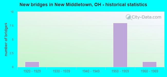
- New bridges - historical statistics
- 11920-1929
- 81950-1959
- 11960-1969

- Reconstructed bridges - Historical Statistics
- 21970-1979
- 21980-1989


- Bridge Condition - Deck
- 20.0%Excellent
- 20.0%Very good
- 20.0%Good
- 40.0%Satisfactory

- Bridge Condition - Superstructure
- 60.0%Good
- 40.0%Satisfactory

- Bridge Condition - Substructure
- 60.0%Very good
- 20.0%Good
- 20.0%Satisfactory
Find on map >> Show street view
Structure Number: 5003997, Location: 1.10 MI N OF SR 630 (Lat: 40.986050, Lng: -80.579281), Route carried "on" structure: State highway 170, Year Built: 1967, Status: Open, Structure Length: 0.73m (2.40ft), Average Daily Traffic: 5,369 (year 2015), Truck Traffic: 6%, Average Future Daily Traffic: 7,452 (year 2035), Design Load: H 15, Features Intersected: BURGESS RUN
Minimum Vertical Clearance: 30+ m (98+ ft), Kilometerpoint: 10.879, Lanes on structure: 2, Owner: State Highway Agency, Approaching Roadway Width: 6.1m (20.0ft), Material/Design: Steel, Design/Construction: Culvert, Number Of Spans In Main Unit: 2, Length of Maximum Span: 3.0m (9.8ft)
Condition: Channel: Satisfactory, Culverts: Satisfactory, Operating Rating: 32.4 metric tons, Method Used To Determine Operating Rating: Load Factor (LF) rating reported by rating factor (RF) method using MS18 loading, Inventory Rating: 25.9 metric tons, Method Used To Determine Inventory Rating: Load Factor (LF) rating reported by rating factor (RF) method using MS18 loading, Structural Evaluation: Equal to present minimum criteria, Waterway Adequacy: Better than present minimum criteria, Approach Roadway Alignment: Better than present minimum criteria, Designated Inspection Frequency: Every 12 months, Inspection Date: November 2021
Find on map >> Show street view
Structure Number: 5029848, Location: 2.7MI EAST OF EXIT 16 (Lat: 40.944131, Lng: -80.614900), Route carried "on" structure: County highway C0161, Year Built: 1954, Year Reconstructed: 1989, Status: Open, Structure Length: 6.16m (20.21ft), Average Daily Traffic: 557 (year 2015), Truck Traffic: 8%, Average Future Daily Traffic: 34,772 (year 2035), Features Intersected: I76 OHIO TPK, Facility Carried by Structure: NEWSPRINGFLD RD
Minimum Vertical Clearance: 30+ m (98+ ft), Kilometerpoint: 5.456, Lanes on structure: 2, Lanes under structure: 4, Owner: State Toll Authority, Approaching Roadway Width: 8.2m (26.9ft), Skew: 1 degrees, Material/Design: Steel continuous, Design/Construction: Stringer/Multi-beam, Number Of Spans In Main Unit: 2, Number Of Approach Spans: 2, Length of Maximum Span: 20.7m (67.9ft), Curb-To-Curb Width: 8.2m (26.9ft), Out-to-Out Width: 9.1m (29.9ft)
Condition: Deck: Good, Superstructure: Good, Substructure: Good, Operating Rating: 55.1 metric tons, Method Used To Determine Operating Rating: Load Factor (LF) rating reported by rating factor (RF) method using MS18 loading, Inventory Rating: 32.4 metric tons, Method Used To Determine Inventory Rating: Load Factor (LF) rating reported by rating factor (RF) method using MS18 loading, Structural Evaluation: Better than present minimum criteria, Deck Geometry: Somewhat better than minimum adequacy, Underclear: High priority of corrective action, Approach Roadway Alignment: Equal to present desirable criteria, Designated Inspection Frequency: Every 24 months, Inspection Date: April 2021, Deck Structure Type: Concrete Cast-file-Place, Wearing Surface/Protective System: Wearing Surface: Monolithic Concrete, Deck Protection: Epoxy Coated Reinforcing
Find on map >> Show street view
Structure Number: 5029864, Location: 2MI WEST OF EXIT 17 (Lat: 40.940839, Lng: -80.595681), Route carried "on" structure: County highway C0167, Year Built: 1954, Year Reconstructed: 1989, Status: Open, Structure Length: 6.13m (20.11ft), Average Daily Traffic: 1,110 (year 2015), Truck Traffic: 7%, Average Future Daily Traffic: 34,772 (year 2035), Design Load: H 10, Features Intersected: I76 OHIO TPK, Facility Carried by Structure: BEARD RD
Minimum Vertical Clearance: 30+ m (98+ ft), Kilometerpoint: 3.267, Lanes on structure: 2, Lanes under structure: 4, Owner: State Toll Authority, Approaching Roadway Width: 8.2m (26.9ft), Skew: 1 degrees, Material/Design: Steel continuous, Design/Construction: Stringer/Multi-beam, Number Of Spans In Main Unit: 2, Number Of Approach Spans: 2, Length of Maximum Span: 20.7m (67.9ft), Curb-To-Curb Width: 8.2m (26.9ft), Out-to-Out Width: 9.1m (29.9ft)
Condition: Deck: Satisfactory, Superstructure: Satisfactory, Substructure: Very good, Operating Rating: 42.1 metric tons, Method Used To Determine Operating Rating: Allowable Stress (AS) rating reported by rating factor (RF) method using MS18 loading, Inventory Rating: 32.4 metric tons, Method Used To Determine Inventory Rating: Allowable Stress (AS) rating reported by rating factor (RF) method using MS18 loading, Structural Evaluation: Equal to present minimum criteria, Deck Geometry: Meets minimum limits, Underclear: High priority of corrective action, Approach Roadway Alignment: Equal to present desirable criteria, Designated Inspection Frequency: Every 12 months, Inspection Date: March 2021, Deck Structure Type: Concrete Cast-file-Place, Wearing Surface/Protective System: Wearing Surface: Bituminous, Deck Protection: Epoxy Coated Reinforcing
Find on map >> Show street view
Structure Number: 502988, Location: 0.9MI WEST OF EXIT 17 (Lat: 40.936050, Lng: -80.576750), Route carried "on" structure: Interstate 76K, Year Built: 1954, Year Reconstructed: 1984, Status: Open, Structure Length: 4.70m (15.42ft), Average Daily Traffic: 12,526 (year 2015), Truck Traffic: 27%, Average Future Daily Traffic: 17,386 (year 2035), Design Load: HS 20, Features Intersected: POLAND-UNITY RD, Facility Carried by Structure: I76 OH TPK
Minimum Vertical Clearance: 12.19m (39.99ft), Kilometerpoint: 30.159, Lanes on structure: 4, Lanes under structure: 2, Base Highway Network: Yes, Toll: On toll road, Owner: State Toll Authority, Approaching Roadway Width: 36.8m (120.7ft), Skew: 34 degrees, Material/Design: Steel continuous, Design/Construction: Stringer/Multi-beam, Number Of Spans In Main Unit: 3, Length of Maximum Span: 15.6m (51.2ft), Curb-To-Curb Width: 36.8m (120.7ft), Out-to-Out Width: 38.7m (127.0ft)
Condition: Deck: Excellent, Superstructure: Good, Substructure: Very good, Operating Rating: 71.3 metric tons, Method Used To Determine Operating Rating: Load Factor (LF) rating reported by rating factor (RF) method using MS18 loading, Inventory Rating: 42.1 metric tons, Method Used To Determine Inventory Rating: Load Factor (LF) rating reported by rating factor (RF) method using MS18 loading, Structural Evaluation: Better than present minimum criteria, Deck Geometry: Superior to present desirable criteria, Underclear: Meets minimum limits, Approach Roadway Alignment: Equal to present desirable criteria, Designated Inspection Frequency: Every 24 months, Inspection Date: March 2021, Deck Structure Type: Concrete Cast-file-Place, Wearing Surface/Protective System: Wearing Surface: Monolithic Concrete, Deck Protection: Epoxy Coated Reinforcing
Find on map >> Show street view
Structure Number: 502991, Location: 0.6MI WEST OF EXIT 17 (Lat: 40.933089, Lng: -80.571989), Route carried "on" structure: Interstate 76K, Year Built: 1954, Year Reconstructed: 1984, Status: Open, Structure Length: 3.84m (12.60ft), Average Daily Traffic: 12,526 (year 2015), Truck Traffic: 27%, Average Future Daily Traffic: 17,386 (year 2035), Design Load: HS 20, Features Intersected: COLUMBIANA RD, Facility Carried by Structure: I76 OH TPK
Minimum Vertical Clearance: 30+ m (98+ ft), Kilometerpoint: 30.658, Lanes on structure: 4, Lanes under structure: 2, Base Highway Network: Yes, Toll: On toll road, Owner: State Toll Authority, Approaching Roadway Width: 36.8m (120.7ft), Skew: 32 degrees, Material/Design: Steel continuous, Design/Construction: Stringer/Multi-beam, Number Of Spans In Main Unit: 3, Length of Maximum Span: 12.5m (41.0ft), Curb-To-Curb Width: 36.8m (120.7ft), Out-to-Out Width: 38.7m (127.0ft)
Condition: Deck: Very good, Superstructure: Good, Substructure: Very good, Operating Rating: 71.3 metric tons, Method Used To Determine Operating Rating: Load Factor (LF) rating reported by rating factor (RF) method using MS18 loading, Inventory Rating: 42.1 metric tons, Method Used To Determine Inventory Rating: Load Factor (LF) rating reported by rating factor (RF) method using MS18 loading, Structural Evaluation: Better than present minimum criteria, Deck Geometry: Superior to present desirable criteria, Underclear: Meets minimum limits, Approach Roadway Alignment: Equal to present desirable criteria, Designated Inspection Frequency: Every 24 months, Inspection Date: Febuary 2020, Deck Structure Type: Concrete Cast-file-Place, Wearing Surface/Protective System: Wearing Surface: Monolithic Concrete, Deck Protection: Epoxy Coated Reinforcing
Find on map >> Show street view
Structure Number: 505633, Location: 0.7MI.W OF UNITY RD. (Lat: 40.935081, Lng: -80.565950), Route carried "on" structure: County highway 62, Year Built: 1925, Status: Open, Structure Length: 0.73m (2.40ft), Average Daily Traffic: 1,276 (year 2015), Truck Traffic: 8%, Average Future Daily Traffic: 1,771 (year 2035), Features Intersected: HONEY CREEK, Facility Carried by Structure: COLUMBIANNA RD.
Minimum Vertical Clearance: 30+ m (98+ ft), Kilometerpoint: 0.626, Lanes on structure: 2, Owner: County Highway Agency, Approaching Roadway Width: 8.8m (28.9ft), Skew: 2 degrees, Material/Design: Concrete, Design/Construction: Slab, Number Of Spans In Main Unit: 1, Length of Maximum Span: 6.4m (21.0ft), Curb-To-Curb Width: 7.4m (24.3ft), Out-to-Out Width: 8.0m (26.2ft)
Condition: Deck: Satisfactory, Superstructure: Satisfactory, Substructure: Satisfactory, Channel: Satisfactory, Operating Rating: 45.4 metric tons, Method Used To Determine Operating Rating: Load Factor (LF) rating reported by rating factor (RF) method using MS18 loading, Inventory Rating: 29.2 metric tons, Method Used To Determine Inventory Rating: Load Factor (LF) rating reported by rating factor (RF) method using MS18 loading, Structural Evaluation: Equal to present minimum criteria, Deck Geometry: Meets minimum limits, Waterway Adequacy: Equal to present desirable criteria, Approach Roadway Alignment: Equal to present desirable criteria, Length Of Structure Improvement: 15.24m (50.00ft), Designated Inspection Frequency: Every 12 months, Inspection Date: September 2021, Bridge Improvement Cost: $45,000, Roadway Improvement Cost: $5,000, Total Project Cost: $100,000, Deck Structure Type: Concrete Cast-file-Place, Wearing Surface/Protective System: Wearing Surface: Bituminous
Find on map >> Show street view
Structure Number: 5029848, Location: 2.7MI EAST OF EXIT 16 (Lat: 40.944131, Lng: -80.614900), Route carried "under" structure: Interstate 76K, Year Built: 1954, Structure Length: 0. m, Average Daily Traffic: 25,052 (year 2015), Truck Traffic: 27%, Features Intersected: NEW SRINGFLD-POLND RD, Facility Carried by Structure: I76 OHIO TPK
Minimum Vertical Clearance: 4.57m (14.99ft), Kilometerpoint: 5.456, Lanes on structure: 2, Lanes under structure: 4, Toll: On toll road, Material/Design: Steel continuous, Design/Construction: Stringer/Multi-beam, Length of Maximum Span: 20.7m (67.9ft)
Find on map >> Show street view
Structure Number: 5029864, Location: 2MI WEST OF EXIT 17 (Lat: 40.940839, Lng: -80.595681), Route carried "under" structure: Interstate 76K, Year Built: 1954, Structure Length: 0. m, Average Daily Traffic: 25,052 (year 2015), Truck Traffic: 27%, Features Intersected: BEARD RD, Facility Carried by Structure: I76 OHIO TPK
Minimum Vertical Clearance: 4.47m (14.67ft), Kilometerpoint: 28.373, Lanes on structure: 2, Lanes under structure: 4, Toll: On toll road, Material/Design: Steel continuous, Design/Construction: Stringer/Multi-beam, Length of Maximum Span: 20.7m (67.9ft)
Find on map >> Show street view
Structure Number: 502988, Location: 0.9MI WEST OF EXIT 17 (Lat: 40.936050, Lng: -80.576750), Route carried "under" structure: County highway 175, Year Built: 1954, Structure Length: 0. m, Average Daily Traffic: 247 (year 2015), Truck Traffic: 8%, Features Intersected: I76 OHIO TPK, Facility Carried by Structure: POLAND-UNITY RD
Minimum Vertical Clearance: 4.29m (14.07ft), Kilometerpoint: 5.359, Lanes on structure: 4, Lanes under structure: 2, Material/Design: Steel continuous, Design/Construction: Stringer/Multi-beam, Length of Maximum Span: 15.6m (51.2ft)
Find on map >> Show street view
Structure Number: 502991, Location: 0.6MI WEST OF EXIT 17 (Lat: 40.933089, Lng: -80.571989), Route carried "under" structure: County highway 62, Year Built: 1954, Structure Length: 0. m, Average Daily Traffic: 1,353 (year 2015), Truck Traffic: 8%, Features Intersected: I76 OHIO TPK, Facility Carried by Structure: COLUMBIANA RD
Minimum Vertical Clearance: 4.29m (14.07ft), Kilometerpoint: 6.502, Lanes on structure: 4, Lanes under structure: 2, Material/Design: Steel continuous, Design/Construction: Stringer/Multi-beam, Length of Maximum Span: 12.5m (41.0ft)