Bridge Statistics for New Sharon, Iowa (IA)
Condition, Traffic, Stress, Structural Evaluation, Project Costs
- National Bridge Inventory (NBI) Statistics
- 24Number of bridges
- 259ft / 79.5mTotal length
- 10,830Total average daily traffic
- 1,872Total average daily truck traffic
- 10,830Total future (year 2040) average daily traffic
- National Bridge Inventory (NBI) Registered Bridges for New Sharon
- No street view available for this location
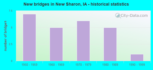
- New bridges - historical statistics
- 71950-1959
- 51960-1969
- 61970-1979
- 51980-1989
- 11990-1999


- Bridge Condition - Deck
- 28.6%Good
- 28.6%Satisfactory
- 28.6%Fair
- 14.3%Poor

- Bridge Condition - Superstructure
- 4.8%Very good
- 28.6%Good
- 42.9%Satisfactory
- 14.3%Fair
- 9.5%Poor

- Bridge Condition - Substructure
- 47.6%Good
- 19.0%Satisfactory
- 9.5%Fair
- 4.8%Poor
- 19.0%Serious

- Bridge Condition - Channel
- 30.4%Good
- 65.2%Satisfactory
- 4.3%Fair

- Bridge Condition - Culverts
- 33.3%Good
- 33.3%Fair
- 33.3%Poor
Find on map >> Show street view
Structure Number: 3491, Location: 3.3 mi. S of jct. IA 146 (Lat: 41.421194, Lng: -92.651231), Route carried "on" structure: US 63, Year Built: 1961, Status: Open, Structure Length: 3.87m (12.70ft), Average Daily Traffic: 3,700 (year 2020), Truck Traffic: 14%, Average Future Daily Traffic: 3,700 (year 2040), Design Load: HS 20, Features Intersected: MIDDLE CREEK
Minimum Vertical Clearance: 30+ m (98+ ft), Kilometerpoint: 119.854, Lanes on structure: 2, Base Highway Network: Yes, Owner: State Highway Agency, Approaching Roadway Width: 10.4m (34.1ft), Skew: 2 degrees, Material/Design: Concrete continuous, Design/Construction: Slab, Number Of Spans In Main Unit: 3, Length of Maximum Span: 14.6m (47.9ft), Curb-To-Curb Width: 9.1m (29.9ft), Out-to-Out Width: 11.0m (36.1ft)
Condition: Deck: Good, Superstructure: Good, Substructure: Good, Channel: Satisfactory, Operating Rating: 62.3 metric tons, Method Used To Determine Operating Rating: Load Factor (LF), Inventory Rating: 37.4 metric tons, Method Used To Determine Inventory Rating: Load Factor (LF), Structural Evaluation: Better than present minimum criteria, Deck Geometry: Meets minimum limits, Waterway Adequacy: Better than present minimum criteria, Approach Roadway Alignment: Equal to present desirable criteria, Designated Inspection Frequency: Every 24 months, Inspection Date: March 2020, Deck Structure Type: Concrete Cast-file-Place, Wearing Surface/Protective System: Wearing Surface: Low Slump Concrete
Find on map >> Show street view
Structure Number: 34921, Location: 0.1 MILES N OF JCT IA 146 (Lat: 41.469700, Lng: -92.647967), Route carried "on" structure: US 63, Year Built: 1985, Status: Open, Structure Length: 4.66m (15.29ft), Average Daily Traffic: 2,070 (year 2020), Truck Traffic: 19%, Average Future Daily Traffic: 2,070 (year 2042), Design Load: HS 20, Features Intersected: UP RR
Minimum Vertical Clearance: 30+ m (98+ ft), Kilometerpoint: 125.532, Lanes on structure: 2, Base Highway Network: Yes, Owner: State Highway Agency, Approaching Roadway Width: 9.1m (29.9ft), Material/Design: Concrete continuous, Design/Construction: Slab, Number Of Spans In Main Unit: 3, Length of Maximum Span: 18.0m (59.1ft), Curb or Sidewalk Widths: Left: 1.5m (4.9ft), Right: 1.5m (4.9ft), Curb-To-Curb Width: 9.8m (32.2ft), Out-to-Out Width: 14.3m (46.9ft)
Condition: Deck: Satisfactory, Superstructure: Satisfactory, Substructure: Good, Operating Rating: 81.6 metric tons, Method Used To Determine Operating Rating: Load Factor (LF), Inventory Rating: 49.0 metric tons, Method Used To Determine Inventory Rating: Load Factor (LF), Structural Evaluation: Equal to present minimum criteria, Deck Geometry: Meets minimum limits, Underclear: Meets minimum limits, Approach Roadway Alignment: Equal to present minimum criteria, Designated Inspection Frequency: Every 24 months, Inspection Date: March 2022, Deck Structure Type: Concrete Cast-file-Place, Wearing Surface/Protective System: Wearing Surface: Monolithic Concrete, Deck Protection: Epoxy Coated Reinforcing
Find on map >> Show street view
Structure Number: 34931, Location: 2.8 mi. E of Jct. IA #146 (Lat: 41.469622, Lng: -92.594161), Route carried "on" structure: US 63, Year Built: 1985, Status: Open, Structure Length: 8.72m (28.61ft), Average Daily Traffic: 1,390 (year 2020), Truck Traffic: 28%, Average Future Daily Traffic: 1,390 (year 2040), Design Load: HS 20, Features Intersected: NORTH SKUNK RIVER
Minimum Vertical Clearance: 30+ m (98+ ft), Kilometerpoint: 130.027, Lanes on structure: 2, Base Highway Network: Yes, Owner: State Highway Agency, Approaching Roadway Width: 13.4m (44.0ft), Skew: 1 degrees, Material/Design: Prestressed concrete, Design/Construction: Stringer/Multi-beam, Number Of Spans In Main Unit: 4, Length of Maximum Span: 25.0m (82.0ft), Curb-To-Curb Width: 12.2m (40.0ft), Out-to-Out Width: 13.2m (43.3ft)
Condition: Deck: Good, Superstructure: Good, Substructure: Good, Channel: Satisfactory, Operating Rating: 64.9 metric tons, Method Used To Determine Operating Rating: Load Factor (LF), Inventory Rating: 39.0 metric tons, Method Used To Determine Inventory Rating: Load Factor (LF), Structural Evaluation: Better than present minimum criteria, Deck Geometry: Better than present minimum criteria, Waterway Adequacy: Better than present minimum criteria, Approach Roadway Alignment: Equal to present desirable criteria, Designated Inspection Frequency: Every 24 months, Inspection Date: March 2020, Deck Structure Type: Concrete Cast-file-Place, Wearing Surface/Protective System: Wearing Surface: Monolithic Concrete, Deck Protection: Epoxy Coated Reinforcing
Find on map >> Show street view
Structure Number: 34941, Location: 3.2 mi. N of Jct. IA 146 (Lat: 41.469700, Lng: -92.590403), Route carried "on" structure: US 63, Year Built: 1985, Status: Open, Structure Length: 5.21m (17.09ft), Average Daily Traffic: 1,390 (year 2020), Truck Traffic: 28%, Average Future Daily Traffic: 1,390 (year 2040), Design Load: HS 20, Features Intersected: BUCK CREEK
Minimum Vertical Clearance: 30+ m (98+ ft), Kilometerpoint: 130.341, Lanes on structure: 2, Base Highway Network: Yes, Owner: State Highway Agency, Approaching Roadway Width: 13.4m (44.0ft), Material/Design: Prestressed concrete, Design/Construction: Stringer/Multi-beam, Number Of Spans In Main Unit: 3, Length of Maximum Span: 25.0m (82.0ft), Curb-To-Curb Width: 12.2m (40.0ft), Out-to-Out Width: 13.2m (43.3ft)
Condition: Deck: Good, Superstructure: Very good, Substructure: Good, Channel: Satisfactory, Operating Rating: 83.7 metric tons, Method Used To Determine Operating Rating: Load Factor (LF), Inventory Rating: 50.1 metric tons, Method Used To Determine Inventory Rating: Load Factor (LF), Structural Evaluation: Better than present minimum criteria, Deck Geometry: Better than present minimum criteria, Waterway Adequacy: Equal to present desirable criteria, Approach Roadway Alignment: Equal to present desirable criteria, Designated Inspection Frequency: Every 24 months, Inspection Date: March 2020, Deck Structure Type: Concrete Cast-file-Place, Wearing Surface/Protective System: Wearing Surface: Monolithic Concrete, Deck Protection: Epoxy Coated Reinforcing
Find on map >> Show street view
Structure Number: 4597, Location: 2.7 MILES N OF JCT US 63 (Lat: 41.508675, Lng: -92.651647), Route carried "on" structure: State highway 146, Year Built: 1958, Status: Open, Structure Length: 9.88m (32.41ft), Average Daily Traffic: 1,310 (year 2020), Truck Traffic: 14%, Average Future Daily Traffic: 1,310 (year 2040), Design Load: H 20, Features Intersected: NORTH SKUNK RIVER
Minimum Vertical Clearance: 30+ m (98+ ft), Kilometerpoint: 4.329, Lanes on structure: 2, Base Highway Network: Yes, Owner: State Highway Agency, Approaching Roadway Width: 12.2m (40.0ft), Skew: 3 degrees, Material/Design: Steel continuous, Design/Construction: Stringer/Multi-beam, Number Of Spans In Main Unit: 3, Length of Maximum Span: 38.1m (125.0ft), Curb-To-Curb Width: 8.6m (28.2ft), Out-to-Out Width: 10.3m (33.8ft)
Condition: Deck: Satisfactory, Superstructure: Satisfactory, Substructure: Satisfactory, Channel: Satisfactory, Operating Rating: 43.9 metric tons, Method Used To Determine Operating Rating: Load Factor (LF), Inventory Rating: 26.3 metric tons, Method Used To Determine Inventory Rating: Load Factor (LF), Structural Evaluation: Equal to present minimum criteria, Deck Geometry: Somewhat better than minimum adequacy, Waterway Adequacy: Better than present minimum criteria, Approach Roadway Alignment: Equal to present minimum criteria, Designated Inspection Frequency: Every 24 months, Inspection Date: May 2020, Deck Structure Type: Concrete Cast-file-Place, Wearing Surface/Protective System: Wearing Surface: Low Slump Concrete
Find on map >> Show street view
Structure Number: 23719, Location: 076150501 (Lat: 41.422683, Lng: -92.615642), Route carried "on" structure: County highway , Year Built: 1950, Status: Posted for load, Structure Length: 1.07m (3.51ft), Average Daily Traffic: 80 (year 2018), Average Future Daily Traffic: 80 (year 2041), Design Load: H 15, Features Intersected: DRAINAGE, Facility Carried by Structure: LOCAL
Minimum Vertical Clearance: 30+ m (98+ ft), Kilometerpoint: 14.962, Lanes on structure: 2, Owner: County Highway Agency, Approaching Roadway Width: 7.9m (25.9ft), Material/Design: Steel, Design/Construction: Stringer/Multi-beam, Number Of Spans In Main Unit: 1, Length of Maximum Span: 10.1m (33.1ft), Curb-To-Curb Width: 5.5m (18.0ft), Out-to-Out Width: 5.9m (19.4ft)
Condition: Deck: Poor, Superstructure: Poor, Substructure: Serious, Channel: Satisfactory, Operating Rating: 7.3 metric tons, Method Used To Determine Operating Rating: Allowable Stress (AS), Inventory Rating: 3.8 metric tons, Method Used To Determine Inventory Rating: Allowable Stress (AS), Structural Evaluation: High priority of replacement, Deck Geometry: Meets minimum limits, Waterway Adequacy: Equal to present minimum criteria, Approach Roadway Alignment: Equal to present minimum criteria, Bridge Posting: Required (Relationship of Operating Rating to Maximum Legal Load: > 39.9% below), Length Of Structure Improvement: 5.60m (18.37ft), Designated Inspection Frequency: Every 12 months, Inspection Date: December 2021, Bridge Improvement Cost: $58,000, Roadway Improvement Cost: $4,000, Deck Structure Type: Concrete Cast-file-Place, Wearing Surface/Protective System: Wearing Surface: Monolithic Concrete
Find on map >> Show street view
Structure Number: 237201, Location: 076150502 (Lat: 41.415456, Lng: -92.622856), Route carried "on" structure: County highway , Year Built: 1983, Status: Open, Structure Length: 0.76m (2.49ft), Average Daily Traffic: 50 (year 2018), Average Future Daily Traffic: 50 (year 2041), Design Load: HS 20, Features Intersected: STREAM, Facility Carried by Structure: LOCAL
Minimum Vertical Clearance: 30+ m (98+ ft), Kilometerpoint: 22.211, Lanes on structure: 2, Owner: County Highway Agency, Approaching Roadway Width: 8.5m (27.9ft), Skew: 3 degrees, Material/Design: Concrete continuous, Design/Construction: Culvert, Number Of Spans In Main Unit: 2, Length of Maximum Span: 3.7m (12.1ft)
Condition: Channel: Satisfactory, Culverts: Good, Operating Rating: 44.1 metric tons, Method Used To Determine Operating Rating: Assigned rating based on Load Factor Design (LFD) reported in metric tons, Inventory Rating: 32.7 metric tons, Method Used To Determine Inventory Rating: Assigned rating based on Load Factor Design (LFD) reported in metric tons, Structural Evaluation: Better than present minimum criteria, Waterway Adequacy: Better than present minimum criteria, Approach Roadway Alignment: Better than present minimum criteria, Length Of Structure Improvement: 2.50m (8.20ft), Designated Inspection Frequency: Every 48 months, Inspection Date: December 2021, Bridge Improvement Cost: $15,000, Roadway Improvement Cost: $2,000
Find on map >> Show street view
Structure Number: 23722, Location: 076150601 (Lat: 41.422636, Lng: -92.632072), Route carried "on" structure: County highway , Year Built: 1950, Status: Posted for load, Structure Length: 0.70m (2.30ft), Average Daily Traffic: 140 (year 2018), Average Future Daily Traffic: 140 (year 2041), Design Load: H 15, Features Intersected: STREAM, Facility Carried by Structure: LOCAL
Minimum Vertical Clearance: 30+ m (98+ ft), Kilometerpoint: 13.589, Lanes on structure: 2, Owner: County Highway Agency, Approaching Roadway Width: 7.6m (24.9ft), Material/Design: Steel, Design/Construction: Stringer/Multi-beam, Number Of Spans In Main Unit: 1, Length of Maximum Span: 6.4m (21.0ft), Curb-To-Curb Width: 5.5m (18.0ft), Out-to-Out Width: 5.9m (19.4ft)
Condition: Deck: Poor, Superstructure: Satisfactory, Substructure: Serious, Channel: Satisfactory, Operating Rating: 14.6 metric tons, Method Used To Determine Operating Rating: Allowable Stress (AS), Inventory Rating: 10.5 metric tons, Method Used To Determine Inventory Rating: Allowable Stress (AS), Structural Evaluation: High priority of replacement, Deck Geometry: High priority of corrective action, Waterway Adequacy: Better than present minimum criteria, Approach Roadway Alignment: Better than present minimum criteria, Bridge Posting: Required (Relationship of Operating Rating to Maximum Legal Load: > 39.9% below), Length Of Structure Improvement: 4.30m (14.11ft), Designated Inspection Frequency: Every 12 months, Inspection Date: December 2021, Bridge Improvement Cost: $50,000, Roadway Improvement Cost: $5,000, Deck Structure Type: Concrete Cast-file-Place, Wearing Surface/Protective System: Wearing Surface: Monolithic Concrete
Find on map >> Show street view
Structure Number: 23727, Location: 076150802 (Lat: 41.406256, Lng: -92.622750), Route carried "on" structure: County highway , Year Built: 1963, Status: Posted for load, Structure Length: 2.35m (7.71ft), Average Daily Traffic: 40 (year 2018), Average Future Daily Traffic: 40 (year 2041), Design Load: H 15, Features Intersected: MIDDLE CREEK, Facility Carried by Structure: LOCAL
Minimum Vertical Clearance: 30+ m (98+ ft), Kilometerpoint: 21.189, Lanes on structure: 2, Owner: County Highway Agency, Approaching Roadway Width: 8.5m (27.9ft), Material/Design: Concrete continuous, Design/Construction: Slab, Number Of Spans In Main Unit: 3, Length of Maximum Span: 8.8m (28.9ft), Curb-To-Curb Width: 6.1m (20.0ft), Out-to-Out Width: 6.8m (22.3ft)
Condition: Deck: Fair, Superstructure: Fair, Substructure: Poor, Channel: Satisfactory, Operating Rating: 33.7 metric tons, Method Used To Determine Operating Rating: Load Factor (LF), Inventory Rating: 20.1 metric tons, Method Used To Determine Inventory Rating: Load Factor (LF), Structural Evaluation: Meets minimum limits, Deck Geometry: Somewhat better than minimum adequacy, Waterway Adequacy: Better than present minimum criteria, Approach Roadway Alignment: Better than present minimum criteria, Bridge Posting: Required (Relationship of Operating Rating to Maximum Legal Load: 10.0 - 19.9% below), Length Of Structure Improvement: 10.10m (33.14ft), Designated Inspection Frequency: Every 24 months, Inspection Date: December 2021, Bridge Improvement Cost: $160,000, Roadway Improvement Cost: $8,000, Deck Structure Type: Concrete Cast-file-Place, Wearing Surface/Protective System: Wearing Surface: Monolithic Concrete
Find on map >> Show street view
Structure Number: 238001, Location: 077150501 (Lat: 41.509147, Lng: -92.622128), Route carried "on" structure: County highway , Year Built: 1996, Status: Open, Structure Length: 3.17m (10.40ft), Average Daily Traffic: 35 (year 2018), Average Future Daily Traffic: 35 (year 2041), Design Load: HS 20, Features Intersected: BUCK CREEK, Facility Carried by Structure: LOCAL
Minimum Vertical Clearance: 30+ m (98+ ft), Kilometerpoint: 10.726, Lanes on structure: 2, Owner: County Highway Agency, Approaching Roadway Width: 12.2m (40.0ft), Skew: 3 degrees, Material/Design: Concrete continuous, Design/Construction: Slab, Number Of Spans In Main Unit: 3, Length of Maximum Span: 11.9m (39.0ft), Curb-To-Curb Width: 9.3m (30.5ft), Out-to-Out Width: 10.1m (33.1ft)
Condition: Deck: Good, Superstructure: Good, Substructure: Good, Channel: Good, Operating Rating: 63.9 metric tons, Method Used To Determine Operating Rating: Allowable Stress (AS), Inventory Rating: 37.7 metric tons, Method Used To Determine Inventory Rating: Allowable Stress (AS), Structural Evaluation: Better than present minimum criteria, Deck Geometry: Better than present minimum criteria, Waterway Adequacy: Equal to present desirable criteria, Approach Roadway Alignment: Equal to present minimum criteria, Length Of Structure Improvement: 10.40m (34.12ft), Designated Inspection Frequency: Every 48 months, Inspection Date: December 2021, Bridge Improvement Cost: $15,000, Roadway Improvement Cost: $2,000, Deck Structure Type: Concrete Cast-file-Place
Find on map >> Show street view
Structure Number: 23803, Location: 077150703 (Lat: 41.494369, Lng: -92.633972), Route carried "on" structure: County highway , Year Built: 1960, Status: Posted for load, Structure Length: 6.16m (20.21ft), Average Daily Traffic: 35 (year 2018), Average Future Daily Traffic: 35 (year 2040), Features Intersected: N SKUNK RIVER, Facility Carried by Structure: G13 110TH ST
Minimum Vertical Clearance: 3.05m (10.01ft), Kilometerpoint: 15.015, Lanes on structure: 2, Owner: County Highway Agency, Approaching Roadway Width: 6.7m (22.0ft), Material/Design: Steel, Design/Construction: Truss - Thru, Number Of Spans In Main Unit: 1, Length of Maximum Span: 61.0m (200.1ft), Curb-To-Curb Width: 5.2m (17.1ft), Out-to-Out Width: 5.6m (18.4ft)
Condition: Deck: Poor, Superstructure: Poor, Substructure: Satisfactory, Channel: Good, Operating Rating: 9.1 metric tons, Method Used To Determine Operating Rating: Allowable Stress (AS), Inventory Rating: 4.5 metric tons, Method Used To Determine Inventory Rating: Allowable Stress (AS), Structural Evaluation: High priority of replacement, Deck Geometry: High priority of replacement, Waterway Adequacy: Better than present minimum criteria, Approach Roadway Alignment: Somewhat better than minimum adequacy, Bridge Posting: Required (Relationship of Operating Rating to Maximum Legal Load: > 39.9% below), Length Of Structure Improvement: 25.00m (82.02ft), Designated Inspection Frequency: Every 24 months, Critical Feature Inspection Frequency: Every 24 months, Inspection Date: December 2020, Critical Feature Inspection Date: August 2021, Bridge Improvement Cost: $450,000, Roadway Improvement Cost: $45,000, Deck Structure Type: Concrete Cast-file-Place, Wearing Surface/Protective System: Wearing Surface: Monolithic Concrete
Find on map >> Show street view
Structure Number: 23804, Location: 077150805 (Lat: 41.495078, Lng: -92.606572), Route carried "on" structure: County highway , Year Built: 1957, Status: Open, Structure Length: 1.28m (4.20ft), Average Daily Traffic: 30 (year 2018), Average Future Daily Traffic: 30 (year 2041), Design Load: H 15, Features Intersected: BUCK CREEK, Facility Carried by Structure: FM
Minimum Vertical Clearance: 30+ m (98+ ft), Kilometerpoint: 17.318, Lanes on structure: 2, Owner: County Highway Agency, Approaching Roadway Width: 6.4m (21.0ft), Material/Design: Steel, Design/Construction: Stringer/Multi-beam, Number Of Spans In Main Unit: 1, Length of Maximum Span: 12.5m (41.0ft), Curb-To-Curb Width: 5.5m (18.0ft), Out-to-Out Width: 5.9m (19.4ft)
Condition: Deck: Fair, Superstructure: Satisfactory, Substructure: Fair, Channel: Satisfactory, Operating Rating: 41.5 metric tons, Method Used To Determine Operating Rating: Allowable Stress (AS), Inventory Rating: 26.8 metric tons, Method Used To Determine Inventory Rating: Allowable Stress (AS), Structural Evaluation: Somewhat better than minimum adequacy, Deck Geometry: Meets minimum limits, Waterway Adequacy: Equal to present minimum criteria, Approach Roadway Alignment: Better than present minimum criteria, Length Of Structure Improvement: 6.40m (21.00ft), Designated Inspection Frequency: Every 24 months, Inspection Date: December 2021, Bridge Improvement Cost: $126,000, Roadway Improvement Cost: $13,000, Deck Structure Type: Concrete Cast-file-Place, Wearing Surface/Protective System: Wearing Surface: Monolithic Concrete
Find on map >> Show street view
Structure Number: 238051, Location: 077150910 (Lat: 41.489519, Lng: -92.589753), Route carried "on" structure: County highway , Year Built: 1988, Status: Open, Structure Length: 3.90m (12.80ft), Average Daily Traffic: 20 (year 2018), Average Future Daily Traffic: 20 (year 2041), Design Load: HS 20, Features Intersected: BUCK CREEK, Facility Carried by Structure: LOCAL
Minimum Vertical Clearance: 30+ m (98+ ft), Kilometerpoint: 13.961, Lanes on structure: 2, Owner: County Highway Agency, Approaching Roadway Width: 8.5m (27.9ft), Material/Design: Concrete continuous, Design/Construction: Slab, Number Of Spans In Main Unit: 3, Length of Maximum Span: 14.9m (48.9ft), Curb-To-Curb Width: 7.3m (24.0ft), Out-to-Out Width: 8.3m (27.2ft)
Condition: Deck: Good, Superstructure: Good, Substructure: Satisfactory, Channel: Good, Operating Rating: 65.9 metric tons, Method Used To Determine Operating Rating: Allowable Stress (AS), Inventory Rating: 38.7 metric tons, Method Used To Determine Inventory Rating: Allowable Stress (AS), Structural Evaluation: Equal to present minimum criteria, Deck Geometry: Equal to present minimum criteria, Waterway Adequacy: Better than present minimum criteria, Approach Roadway Alignment: Equal to present desirable criteria, Length Of Structure Improvement: 12.80m (41.99ft), Designated Inspection Frequency: Every 48 months, Inspection Date: December 2021, Bridge Improvement Cost: $15,000, Roadway Improvement Cost: $2,000, Deck Structure Type: Concrete Cast-file-Place, Wearing Surface/Protective System: Wearing Surface: Monolithic Concrete
Find on map >> Show street view
Structure Number: 238071, Location: 077151607 (Lat: 41.480122, Lng: -92.590383), Route carried "on" structure: County highway , Year Built: 1975, Status: Open, Structure Length: 3.90m (12.80ft), Average Daily Traffic: 30 (year 2018), Average Future Daily Traffic: 30 (year 2041), Design Load: H 15, Features Intersected: BUCK CR, Facility Carried by Structure: LOCAL
Minimum Vertical Clearance: 30+ m (98+ ft), Kilometerpoint: 13.602, Lanes on structure: 2, Owner: County Highway Agency, Approaching Roadway Width: 8.5m (27.9ft), Material/Design: Concrete continuous, Design/Construction: Slab, Number Of Spans In Main Unit: 3, Length of Maximum Span: 14.9m (48.9ft), Curb-To-Curb Width: 7.4m (24.3ft), Out-to-Out Width: 8.0m (26.2ft)
Condition: Deck: Good, Superstructure: Good, Substructure: Good, Channel: Good, Operating Rating: 37.2 metric tons, Method Used To Determine Operating Rating: Load Factor (LF), Inventory Rating: 22.3 metric tons, Method Used To Determine Inventory Rating: Load Factor (LF), Structural Evaluation: Equal to present minimum criteria, Deck Geometry: Equal to present minimum criteria, Waterway Adequacy: Better than present minimum criteria, Approach Roadway Alignment: Better than present minimum criteria, Length Of Structure Improvement: 12.80m (41.99ft), Designated Inspection Frequency: Every 24 months, Inspection Date: December 2021, Bridge Improvement Cost: $15,000, Roadway Improvement Cost: $2,000, Deck Structure Type: Concrete Cast-file-Place, Wearing Surface/Protective System: Wearing Surface: Monolithic Concrete
Find on map >> Show street view
Structure Number: 23809, Location: 077151703 (Lat: 41.471514, Lng: -92.619128), Route carried "on" structure: County highway , Year Built: 1977, Status: Open, Structure Length: 7.74m (25.39ft), Average Daily Traffic: 70 (year 2018), Average Future Daily Traffic: 70 (year 2041), Design Load: H 15, Features Intersected: N SKUNK RIVER, Facility Carried by Structure: LOCAL
Minimum Vertical Clearance: 30+ m (98+ ft), Kilometerpoint: 8.806, Lanes on structure: 2, Owner: County Highway Agency, Approaching Roadway Width: 7.9m (25.9ft), Skew: 1 degrees, Material/Design: Steel continuous, Design/Construction: Stringer/Multi-beam, Number Of Spans In Main Unit: 3, Length of Maximum Span: 29.9m (98.1ft), Curb-To-Curb Width: 7.3m (24.0ft), Out-to-Out Width: 8.0m (26.2ft)
Condition: Deck: Fair, Superstructure: Good, Substructure: Good, Channel: Good, Operating Rating: 36.1 metric tons, Method Used To Determine Operating Rating: Load Factor (LF), Inventory Rating: 21.6 metric tons, Method Used To Determine Inventory Rating: Load Factor (LF), Structural Evaluation: Equal to present minimum criteria, Deck Geometry: Equal to present minimum criteria, Waterway Adequacy: Equal to present desirable criteria, Approach Roadway Alignment: Equal to present minimum criteria, Length Of Structure Improvement: 25.40m (83.33ft), Designated Inspection Frequency: Every 24 months, Inspection Date: December 2021, Bridge Improvement Cost: $15,000, Roadway Improvement Cost: $2,000, Deck Structure Type: Concrete Cast-file-Place, Wearing Surface/Protective System: Wearing Surface: Monolithic Concrete
Find on map >> Show street view
Structure Number: 2381, Location: 077152204 (Lat: 41.452492, Lng: -92.584689), Route carried "on" structure: County highway , Year Built: 1965, Status: Open, Structure Length: 0.76m (2.49ft), Average Daily Traffic: 50 (year 2018), Average Future Daily Traffic: 50 (year 2041), Features Intersected: STREAM, Facility Carried by Structure: LOCAL
Minimum Vertical Clearance: 30+ m (98+ ft), Kilometerpoint: 11.010, Lanes on structure: 2, Owner: County Highway Agency, Approaching Roadway Width: 6.1m (20.0ft), Material/Design: Concrete continuous, Design/Construction: Culvert, Number Of Spans In Main Unit: 2, Length of Maximum Span: 3.7m (12.1ft)
Condition: Channel: Good, Culverts: Fair, Operating Rating: 51.8 metric tons, Method Used To Determine Operating Rating: Load Factor (LF), Inventory Rating: 31.0 metric tons, Method Used To Determine Inventory Rating: Load Factor (LF), Structural Evaluation: Somewhat better than minimum adequacy, Waterway Adequacy: Better than present minimum criteria, Approach Roadway Alignment: Meets minimum limits, Length Of Structure Improvement: 2.50m (8.20ft), Designated Inspection Frequency: Every 24 months, Inspection Date: December 2021, Bridge Improvement Cost: $30,000, Roadway Improvement Cost: $5,000
Find on map >> Show street view
Structure Number: 23818, Location: 077153203 (Lat: 41.437144, Lng: -92.613361), Route carried "on" structure: County highway , Year Built: 1954, Status: Posted for load, Structure Length: 0.76m (2.49ft), Average Daily Traffic: 45 (year 2018), Average Future Daily Traffic: 45 (year 2041), Design Load: H 15, Features Intersected: DRAINAGE, Facility Carried by Structure: FM
Minimum Vertical Clearance: 30+ m (98+ ft), Kilometerpoint: 8.121, Lanes on structure: 2, Owner: County Highway Agency, Approaching Roadway Width: 7.0m (23.0ft), Material/Design: Concrete, Design/Construction: Channel Beam, Number Of Spans In Main Unit: 1, Length of Maximum Span: 7.0m (23.0ft), Curb-To-Curb Width: 6.4m (21.0ft), Out-to-Out Width: 6.9m (22.6ft)
Condition: Deck: Fair, Superstructure: Fair, Substructure: Serious, Channel: Satisfactory, Operating Rating: 6.0 metric tons, Method Used To Determine Operating Rating: Allowable Stress (AS), Inventory Rating: 2.9 metric tons, Method Used To Determine Inventory Rating: Allowable Stress (AS), Structural Evaluation: High priority of replacement, Deck Geometry: Somewhat better than minimum adequacy, Waterway Adequacy: Equal to present minimum criteria, Approach Roadway Alignment: Better than present minimum criteria, Bridge Posting: Required (Relationship of Operating Rating to Maximum Legal Load: > 39.9% below), Length Of Structure Improvement: 4.50m (14.76ft), Designated Inspection Frequency: Every 12 months, Inspection Date: December 2021, Bridge Improvement Cost: $90,000, Roadway Improvement Cost: $9,000, Deck Structure Type: Concrete Cast-file-Place, Wearing Surface/Protective System: Wearing Surface: Monolithic Concrete
Find on map >> Show street view
Structure Number: 23823, Location: 077162102 (Lat: 41.459103, Lng: -92.718825), Route carried "on" structure: County highway , Year Built: 1953, Status: Open, Structure Length: 1.10m (3.61ft), Average Daily Traffic: 30 (year 2018), Average Future Daily Traffic: 30 (year 2041), Design Load: H 15, Features Intersected: MIDDLE CREEK, Facility Carried by Structure: LOCAL
Minimum Vertical Clearance: 30+ m (98+ ft), Kilometerpoint: 19.887, Lanes on structure: 2, Owner: County Highway Agency, Approaching Roadway Width: 6.7m (22.0ft), Material/Design: Steel, Design/Construction: Stringer/Multi-beam, Number Of Spans In Main Unit: 1, Length of Maximum Span: 10.1m (33.1ft), Curb-To-Curb Width: 6.0m (19.7ft), Out-to-Out Width: 6.5m (21.3ft)
Condition: Deck: Fair, Superstructure: Fair, Substructure: Satisfactory, Channel: Satisfactory, Operating Rating: 50.7 metric tons, Method Used To Determine Operating Rating: Load Factor (LF), Inventory Rating: 30.4 metric tons, Method Used To Determine Inventory Rating: Load Factor (LF), Structural Evaluation: Somewhat better than minimum adequacy, Deck Geometry: Meets minimum limits, Waterway Adequacy: Equal to present minimum criteria, Approach Roadway Alignment: Better than present minimum criteria, Length Of Structure Improvement: 5.70m (18.70ft), Designated Inspection Frequency: Every 24 months, Inspection Date: December 2021, Bridge Improvement Cost: $75,000, Roadway Improvement Cost: $5,000, Deck Structure Type: Concrete Cast-file-Place, Wearing Surface/Protective System: Wearing Surface: Monolithic Concrete
Find on map >> Show street view
Structure Number: 23824, Location: 077162202 (Lat: 41.453981, Lng: -92.699550), Route carried "on" structure: County highway , Year Built: 1963, Status: Posted for load, Structure Length: 1.77m (5.81ft), Average Daily Traffic: 25 (year 2018), Average Future Daily Traffic: 25 (year 2041), Design Load: H 15, Features Intersected: MIDDLE CREEK, Facility Carried by Structure: FM
Minimum Vertical Clearance: 30+ m (98+ ft), Kilometerpoint: 7.646, Lanes on structure: 2, Owner: County Highway Agency, Approaching Roadway Width: 7.3m (24.0ft), Material/Design: Steel, Design/Construction: Stringer/Multi-beam, Number Of Spans In Main Unit: 1, Length of Maximum Span: 16.8m (55.1ft), Curb-To-Curb Width: 6.1m (20.0ft), Out-to-Out Width: 6.7m (22.0ft)
Condition: Deck: Fair, Superstructure: Satisfactory, Substructure: Serious, Channel: Satisfactory, Operating Rating: 10.5 metric tons, Method Used To Determine Operating Rating: Allowable Stress (AS), Structural Evaluation: High priority of replacement, Deck Geometry: Somewhat better than minimum adequacy, Waterway Adequacy: Equal to present minimum criteria, Approach Roadway Alignment: Better than present minimum criteria, Bridge Posting: Required (Relationship of Operating Rating to Maximum Legal Load: > 39.9% below), Length Of Structure Improvement: 8.10m (26.57ft), Designated Inspection Frequency: Every 12 months, Inspection Date: December 2021, Bridge Improvement Cost: $105,000, Roadway Improvement Cost: $5,000, Deck Structure Type: Concrete Cast-file-Place, Wearing Surface/Protective System: Wearing Surface: Monolithic Concrete
Find on map >> Show street view
Structure Number: 238245, Location: 077162303 (Lat: 41.458744, Lng: -92.675281), Route carried "on" structure: County highway , Year Built: 1953, Status: Open, Structure Length: 0.67m (2.20ft), Average Daily Traffic: 60 (year 2018), Average Future Daily Traffic: 60 (year 2041), Features Intersected: STREAM, Facility Carried by Structure: LOCAL
Minimum Vertical Clearance: 30+ m (98+ ft), Kilometerpoint: 3.195, Lanes on structure: 2, Owner: County Highway Agency, Approaching Roadway Width: 7.6m (24.9ft), Skew: 1 degrees, Material/Design: Concrete continuous, Design/Construction: Culvert, Number Of Spans In Main Unit: 2, Length of Maximum Span: 3.0m (9.8ft)
Condition: Channel: Fair, Culverts: Poor, Operating Rating: 25.4 metric tons, Method Used To Determine Operating Rating: Field evaluation and documented engineering judgment, Inventory Rating: 13.6 metric tons, Method Used To Determine Inventory Rating: Field evaluation and documented engineering judgment, Structural Evaluation: Meets minimum limits, Waterway Adequacy: Somewhat better than minimum adequacy, Approach Roadway Alignment: Equal to present minimum criteria, Length Of Structure Improvement: 2.00m (6.56ft), Designated Inspection Frequency: Every 24 months, Inspection Date: December 2021, Bridge Improvement Cost: $70,000, Roadway Improvement Cost: $3,000
Find on map >> Show street view
Structure Number: 238261, Location: 077162602 (Lat: 41.444744, Lng: -92.680356), Route carried "on" structure: County highway , Year Built: 1971, Status: Open, Structure Length: 2.38m (7.81ft), Average Daily Traffic: 60 (year 2018), Average Future Daily Traffic: 60 (year 2041), Design Load: H 15, Features Intersected: MIDDLE CREEK, Facility Carried by Structure: LOCAL
Minimum Vertical Clearance: 30+ m (98+ ft), Kilometerpoint: 16.393, Lanes on structure: 2, Owner: County Highway Agency, Approaching Roadway Width: 7.3m (24.0ft), Skew: 3 degrees, Material/Design: Concrete continuous, Design/Construction: Slab, Number Of Spans In Main Unit: 3, Length of Maximum Span: 8.8m (28.9ft), Curb-To-Curb Width: 7.3m (24.0ft), Out-to-Out Width: 8.0m (26.2ft)
Condition: Deck: Satisfactory, Superstructure: Satisfactory, Substructure: Good, Channel: Satisfactory, Operating Rating: 37.0 metric tons, Method Used To Determine Operating Rating: Load Factor (LF), Inventory Rating: 22.1 metric tons, Method Used To Determine Inventory Rating: Load Factor (LF), Structural Evaluation: Equal to present minimum criteria, Deck Geometry: Equal to present minimum criteria, Waterway Adequacy: Equal to present minimum criteria, Approach Roadway Alignment: Better than present minimum criteria, Length Of Structure Improvement: 7.00m (22.97ft), Designated Inspection Frequency: Every 24 months, Inspection Date: December 2021, Bridge Improvement Cost: $15,000, Roadway Improvement Cost: $2,000, Deck Structure Type: Concrete Cast-file-Place, Wearing Surface/Protective System: Wearing Surface: Monolithic Concrete
Find on map >> Show street view
Structure Number: 238311, Location: 077162608 (Lat: 41.439161, Lng: -92.670658), Route carried "on" structure: County highway , Year Built: 1971, Status: Open, Structure Length: 2.38m (7.81ft), Average Daily Traffic: 50 (year 2018), Average Future Daily Traffic: 50 (year 2041), Design Load: H 15, Features Intersected: MIDDLE CREEK, Facility Carried by Structure: LOCAL
Minimum Vertical Clearance: 30+ m (98+ ft), Kilometerpoint: 17.754, Lanes on structure: 2, Owner: County Highway Agency, Approaching Roadway Width: 7.9m (25.9ft), Skew: 2 degrees, Material/Design: Concrete continuous, Design/Construction: Slab, Number Of Spans In Main Unit: 3, Length of Maximum Span: 8.8m (28.9ft), Curb-To-Curb Width: 7.3m (24.0ft), Out-to-Out Width: 8.0m (26.2ft)
Condition: Deck: Satisfactory, Superstructure: Satisfactory, Substructure: Good, Channel: Good, Operating Rating: 37.0 metric tons, Method Used To Determine Operating Rating: Load Factor (LF), Inventory Rating: 22.1 metric tons, Method Used To Determine Inventory Rating: Load Factor (LF), Structural Evaluation: Equal to present minimum criteria, Deck Geometry: Equal to present minimum criteria, Waterway Adequacy: Better than present minimum criteria, Approach Roadway Alignment: Equal to present desirable criteria, Length Of Structure Improvement: 10.20m (33.46ft), Designated Inspection Frequency: Every 24 months, Inspection Date: December 2021, Bridge Improvement Cost: $140,000, Roadway Improvement Cost: $10,000, Deck Structure Type: Concrete Cast-file-Place, Wearing Surface/Protective System: Wearing Surface: Monolithic Concrete
Find on map >> Show street view
Structure Number: 238361, Location: 077163503 (Lat: 41.437025, Lng: -92.665261), Route carried "on" structure: County highway , Year Built: 1971, Status: Open, Structure Length: 3.14m (10.30ft), Average Daily Traffic: 60 (year 2018), Average Future Daily Traffic: 60 (year 2041), Design Load: H 20, Features Intersected: MIDDLE CREEK, Facility Carried by Structure: FM
Minimum Vertical Clearance: 30+ m (98+ ft), Kilometerpoint: 3.785, Lanes on structure: 2, Owner: County Highway Agency, Approaching Roadway Width: 8.5m (27.9ft), Skew: 1 degrees, Material/Design: Concrete continuous, Design/Construction: Slab, Number Of Spans In Main Unit: 3, Length of Maximum Span: 11.9m (39.0ft), Curb-To-Curb Width: 8.6m (28.2ft), Out-to-Out Width: 9.2m (30.2ft)
Condition: Deck: Satisfactory, Superstructure: Satisfactory, Substructure: Good, Channel: Satisfactory, Operating Rating: 50.2 metric tons, Method Used To Determine Operating Rating: Allowable Stress (AS), Inventory Rating: 30.6 metric tons, Method Used To Determine Inventory Rating: Allowable Stress (AS), Structural Evaluation: Equal to present minimum criteria, Deck Geometry: Better than present minimum criteria, Waterway Adequacy: Equal to present minimum criteria, Approach Roadway Alignment: Better than present minimum criteria, Length Of Structure Improvement: 13.20m (43.31ft), Designated Inspection Frequency: Every 24 months, Inspection Date: December 2021, Bridge Improvement Cost: $336,000, Roadway Improvement Cost: $34,000, Deck Structure Type: Concrete Cast-file-Place, Wearing Surface/Protective System: Wearing Surface: Monolithic Concrete
Find on map >> Show street view
Structure Number: 291781, Location: 078153005 (Lat: 41.530872, Lng: -92.635206), Route carried "on" structure: County highway , Year Built: 1977, Status: Open, Structure Length: 3.14m (10.30ft), Average Daily Traffic: 60 (year 2018), Average Future Daily Traffic: 60 (year 2041), Design Load: HS 20, Features Intersected: BUCK CREEK, Facility Carried by Structure: FM
Minimum Vertical Clearance: 30+ m (98+ ft), Kilometerpoint: 1.617, Lanes on structure: 2, Owner: County Highway Agency, Approaching Roadway Width: 8.8m (28.9ft), Skew: 1 degrees, Material/Design: Prestressed concrete, Design/Construction: Tee Beam, Number Of Spans In Main Unit: 3, Length of Maximum Span: 12.5m (41.0ft), Curb or Sidewalk Widths: Left: 0.3m (1.0ft), Right: 0.3m (1.0ft), Curb-To-Curb Width: 9.1m (29.9ft), Out-to-Out Width: 9.8m (32.2ft)
Condition: Deck: Satisfactory, Superstructure: Satisfactory, Substructure: Fair, Channel: Satisfactory, Operating Rating: 80.8 metric tons, Method Used To Determine Operating Rating: Load Factor (LF), Inventory Rating: 43.7 metric tons, Method Used To Determine Inventory Rating: Load Factor (LF), Structural Evaluation: Somewhat better than minimum adequacy, Deck Geometry: Better than present minimum criteria, Waterway Adequacy: Equal to present desirable criteria, Approach Roadway Alignment: Equal to present desirable criteria, Length Of Structure Improvement: 10.30m (33.79ft), Designated Inspection Frequency: Every 24 months, Inspection Date: December 2021, Bridge Improvement Cost: $15,000, Roadway Improvement Cost: $2,000, Deck Structure Type: Concrete Precast Panels, Wearing Surface/Protective System: Wearing Surface: Monolithic Concrete