Bridge Statistics for New Tripoli, Pennsylvania (PA)
Condition, Traffic, Stress, Structural Evaluation, Project Costs
- National Bridge Inventory (NBI) Statistics
- 18Number of bridges
- 92ft / 28.1mTotal length
- $798,000Total costs
- 27,070Total average daily traffic
- 2,099Total average daily truck traffic
- 37,986Total future (year 2000) average daily traffic
- National Bridge Inventory (NBI) Registered Bridges for New Tripoli
- No street view available for this location
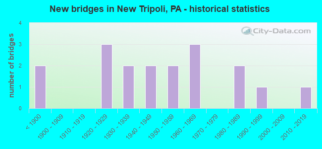
- New bridges - historical statistics
- 2Before 1900
- 31920-1929
- 21930-1939
- 21940-1949
- 21950-1959
- 31960-1969
- 21980-1989
- 11990-1999
- 12010-2019
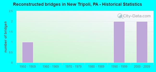
- Reconstructed bridges - Historical Statistics
- 11950-1959
- 01960-1969
- 01970-1979
- 01980-1989
- 21990-1999
- 22000-2009
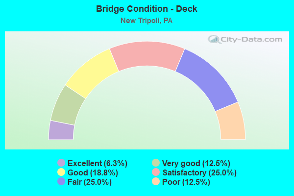
- Bridge Condition - Deck
- 6.3%Excellent
- 12.5%Very good
- 18.8%Good
- 25.0%Satisfactory
- 25.0%Fair
- 12.5%Poor
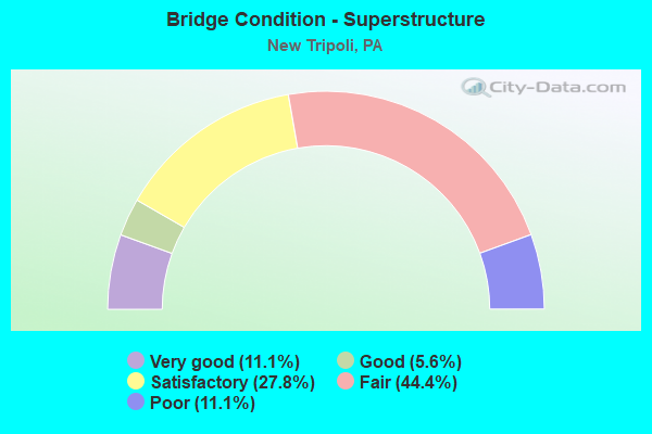
- Bridge Condition - Superstructure
- 11.1%Very good
- 5.6%Good
- 27.8%Satisfactory
- 44.4%Fair
- 11.1%Poor
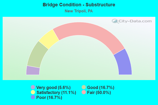
- Bridge Condition - Substructure
- 5.6%Very good
- 16.7%Good
- 11.1%Satisfactory
- 50.0%Fair
- 16.7%Poor
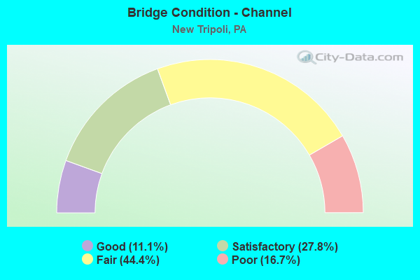
- Bridge Condition - Channel
- 11.1%Good
- 27.8%Satisfactory
- 44.4%Fair
- 16.7%Poor
Find on map >> Show street view
Structure Number: 23094, Location: PA 100 @ SADDLE ROAD (Lat: 40.672292, Lng: -75.689492), Route carried "on" structure: State highway 100, Year Built: 1964, Year Reconstructed: 1990, Status: Open, Structure Length: 2.13m (6.99ft), Average Daily Traffic: 9,688 (year 2021), Truck Traffic: 10%, Average Future Daily Traffic: 12,956 (year 2032), Design Load: HS 20, Features Intersected: JORDAN CREEK
Minimum Vertical Clearance: 30+ m (98+ ft), Kilometerpoint: 25.394, Lanes on structure: 2, Base Highway Network: Yes, Owner: State Highway Agency, Approaching Roadway Width: 12.2m (40.0ft), Skew: 4 degrees, Material/Design: Prestressed concrete, Design/Construction: Box Beam or Girders - Single/Spread, Number Of Spans In Main Unit: 2, Length of Maximum Span: 10.4m (34.1ft), Curb or Sidewalk Widths: Left: 0.2m (0.7ft), Right: 0.2m (0.7ft), Curb-To-Curb Width: 13.1m (43.0ft), Out-to-Out Width: 13.9m (45.6ft)
Condition: Deck: Good, Superstructure: Satisfactory, Substructure: Fair, Channel: Fair, Operating Rating: 47.2 metric tons, Method Used To Determine Operating Rating: Load Factor (LF), Inventory Rating: 28.1 metric tons, Method Used To Determine Inventory Rating: Load Factor (LF), Structural Evaluation: Somewhat better than minimum adequacy, Deck Geometry: Somewhat better than minimum adequacy, Waterway Adequacy: Equal to present minimum criteria, Approach Roadway Alignment: Equal to present desirable criteria, Length Of Structure Improvement: 2.70m (8.86ft), Designated Inspection Frequency: Every 24 months, Inspection Date: January 2020, Bridge Improvement Cost: $9,000, Roadway Improvement Cost: $26,000, Total Project Cost: $119,000, Deck Structure Type: Concrete Cast-file-Place, Wearing Surface/Protective System: Wearing Surface: Latex Concrete
Find on map >> Show street view
Structure Number: 23099, Location: KINGS HIGHWAY,LYNNPORT (Lat: 40.677031, Lng: -75.801331), Route carried "on" structure: State highway 143, Year Built: 1926, Status: Open, Structure Length: 0.70m (2.30ft), Average Daily Traffic: 2,245 (year 2022), Truck Traffic: 10%, Average Future Daily Traffic: 2,801 (year 2032), Design Load: HS 20, Features Intersected: TRIB. ONTELAUNEE CREEK
Minimum Vertical Clearance: 30+ m (98+ ft), Kilometerpoint: 5.530, Lanes on structure: 2, Owner: State Highway Agency, Approaching Roadway Width: 7.3m (24.0ft), Material/Design: Concrete, Design/Construction: Tee Beam, Number Of Spans In Main Unit: 1, Length of Maximum Span: 6.4m (21.0ft), Curb-To-Curb Width: 7.1m (23.3ft), Out-to-Out Width: 7.9m (25.9ft)
Condition: Deck: Satisfactory, Superstructure: Fair, Substructure: Fair, Channel: Fair, Operating Rating: 52.6 metric tons, Method Used To Determine Operating Rating: Load Factor (LF), Inventory Rating: 31.8 metric tons, Method Used To Determine Inventory Rating: Load Factor (LF), Structural Evaluation: Somewhat better than minimum adequacy, Deck Geometry: High priority of replacement, Waterway Adequacy: Equal to present minimum criteria, Approach Roadway Alignment: Equal to present desirable criteria, Length Of Structure Improvement: 1.30m (4.27ft), Designated Inspection Frequency: Every 24 months, Inspection Date: August 2020, Bridge Improvement Cost: $3,000, Roadway Improvement Cost: $7,000, Total Project Cost: $35,000, Deck Structure Type: Concrete Cast-file-Place, Wearing Surface/Protective System: Wearing Surface: Bituminous
Find on map >> Show street view
Structure Number: 23101, Location: NEW TRIPOLI (Lat: 40.683772, Lng: -75.762972), Route carried "on" structure: State highway 143, Year Built: 1926, Status: Open, Structure Length: 1.25m (4.10ft), Average Daily Traffic: 2,287 (year 2021), Truck Traffic: 6%, Average Future Daily Traffic: 3,086 (year 2032), Design Load: HS 20, Features Intersected: BR. ONTELAUNEE CREEK
Minimum Vertical Clearance: 30+ m (98+ ft), Kilometerpoint: 9.228, Lanes on structure: 2, Owner: State Highway Agency, Approaching Roadway Width: 7.3m (24.0ft), Skew: 3 degrees, Material/Design: Concrete, Design/Construction: Tee Beam, Number Of Spans In Main Unit: 1, Length of Maximum Span: 11.9m (39.0ft), Curb-To-Curb Width: 7.1m (23.3ft), Out-to-Out Width: 7.8m (25.6ft)
Condition: Deck: Satisfactory, Superstructure: Fair, Substructure: Fair, Channel: Fair, Operating Rating: 53.5 metric tons, Method Used To Determine Operating Rating: Load Factor (LF), Inventory Rating: 31.8 metric tons, Method Used To Determine Inventory Rating: Load Factor (LF), Structural Evaluation: Somewhat better than minimum adequacy, Deck Geometry: High priority of replacement, Waterway Adequacy: Equal to present desirable criteria, Approach Roadway Alignment: Better than present minimum criteria, Length Of Structure Improvement: 1.90m (6.23ft), Designated Inspection Frequency: Every 24 months, Inspection Date: November 2020, Bridge Improvement Cost: $4,000, Roadway Improvement Cost: $10,000, Total Project Cost: $48,000, Deck Structure Type: Concrete Cast-file-Place, Wearing Surface/Protective System: Wearing Surface: Bituminous
Find on map >> Show street view
Structure Number: 23102, Location: ONTELAUNEE PARK (Lat: 40.681400, Lng: -75.761017), Route carried "on" structure: State highway 143, Year Built: 1921, Status: Open, Structure Length: 0.91m (2.99ft), Average Daily Traffic: 2,287 (year 2021), Truck Traffic: 6%, Average Future Daily Traffic: 3,086 (year 2032), Design Load: HS 20, Features Intersected: ONTELAUNEE CREEK
Minimum Vertical Clearance: 30+ m (98+ ft), Kilometerpoint: 9.228, Lanes on structure: 2, Owner: State Highway Agency, Approaching Roadway Width: 7.0m (23.0ft), Skew: 1 degrees, Material/Design: Concrete, Design/Construction: Tee Beam, Number Of Spans In Main Unit: 1, Length of Maximum Span: 8.2m (26.9ft), Curb-To-Curb Width: 6.9m (22.6ft), Out-to-Out Width: 7.7m (25.3ft)
Condition: Deck: Fair, Superstructure: Fair, Substructure: Satisfactory, Channel: Fair, Operating Rating: 74.4 metric tons, Method Used To Determine Operating Rating: Field evaluation and documented engineering judgment, Inventory Rating: 44.5 metric tons, Method Used To Determine Inventory Rating: Field evaluation and documented engineering judgment, Structural Evaluation: Somewhat better than minimum adequacy, Deck Geometry: High priority of replacement, Waterway Adequacy: Equal to present minimum criteria, Approach Roadway Alignment: Equal to present desirable criteria, Length Of Structure Improvement: 1.60m (5.25ft), Designated Inspection Frequency: Every 24 months, Inspection Date: November 2020, Bridge Improvement Cost: $3,000, Roadway Improvement Cost: $9,000, Total Project Cost: $41,000, Deck Structure Type: Concrete Cast-file-Place, Wearing Surface/Protective System: Wearing Surface: Bituminous
Find on map >> Show street view
Structure Number: 23172, Location: PLEASANT CORNERS (Lat: 40.681967, Lng: -75.693233), Route carried "on" structure: State highway 309, Year Built: 1962, Year Reconstructed: 2011, Status: Open, Structure Length: 1.37m (4.49ft), Average Daily Traffic: 6,523 (year 2020), Truck Traffic: 7%, Average Future Daily Traffic: 9,857 (year 2032), Design Load: HL 93, Features Intersected: JORDAN CREEK
Minimum Vertical Clearance: 30+ m (98+ ft), Kilometerpoint: 28.920, Lanes on structure: 2, Base Highway Network: Yes, Owner: State Highway Agency, Approaching Roadway Width: 11.6m (38.1ft), Skew: 3 degrees, Material/Design: Prestressed concrete, Design/Construction: Box Beam or Girders - Single/Spread, Number Of Spans In Main Unit: 1, Length of Maximum Span: 13.4m (44.0ft), Curb-To-Curb Width: 12.2m (40.0ft), Out-to-Out Width: 13.1m (43.0ft)
Condition: Deck: Very good, Superstructure: Very good, Substructure: Good, Channel: Satisfactory, Operating Rating: 63.8 metric tons, Method Used To Determine Operating Rating: Assigned ratings based on Load and Resistance Factor Design (LRFD) reported by rating factor (RF) using HL93 loadings, Inventory Rating: 39.9 metric tons, Method Used To Determine Inventory Rating: Assigned ratings based on Load and Resistance Factor Design (LRFD) reported by rating factor (RF) using HL93 loadings, Structural Evaluation: Better than present minimum criteria, Deck Geometry: Somewhat better than minimum adequacy, Waterway Adequacy: Equal to present desirable criteria, Approach Roadway Alignment: Equal to present desirable criteria, Length Of Structure Improvement: 2.10m (6.89ft), Designated Inspection Frequency: Every 48 months, Inspection Date: October 2019, Deck Structure Type: Concrete Cast-file-Place, Wearing Surface/Protective System: Wearing Surface: Monolithic Concrete, Deck Protection: Epoxy Coated Reinforcing
Find on map >> Show street view
Structure Number: 23385, Location: WERLEYS CORNER ROAD (Lat: 40.659056, Lng: -75.704864), Route carried "on" structure: State highway , Year Built: 1937, Status: Open, Structure Length: 1.55m (5.09ft), Average Daily Traffic: 733 (year 2022), Truck Traffic: 6%, Average Future Daily Traffic: 1,013 (year 2032), Design Load: HS 20, Features Intersected: SWEITZER CREEK, Facility Carried by Structure: SR 4019 (LR 39063)
Minimum Vertical Clearance: 30+ m (98+ ft), Kilometerpoint: 5.604, Lanes on structure: 2, Owner: State Highway Agency, Approaching Roadway Width: 5.8m (19.0ft), Skew: 4 degrees, Material/Design: Steel, Design/Construction: Stringer/Multi-beam, Number Of Spans In Main Unit: 1, Length of Maximum Span: 14.3m (46.9ft), Curb-To-Curb Width: 7.9m (25.9ft), Out-to-Out Width: 8.7m (28.5ft)
Condition: Deck: Fair, Superstructure: Fair, Substructure: Poor, Channel: Fair, Operating Rating: 46.3 metric tons, Method Used To Determine Operating Rating: Load Factor (LF), Inventory Rating: 27.2 metric tons, Method Used To Determine Inventory Rating: Load Factor (LF), Structural Evaluation: Meets minimum limits, Deck Geometry: Somewhat better than minimum adequacy, Waterway Adequacy: Superior to present desirable criteria, Approach Roadway Alignment: Somewhat better than minimum adequacy, Length Of Structure Improvement: 2.20m (7.22ft), Designated Inspection Frequency: Every 24 months, Inspection Date: May 2021, Bridge Improvement Cost: $5,000, Roadway Improvement Cost: $13,000, Total Project Cost: $62,000, Deck Structure Type: Closed Grating, Wearing Surface/Protective System: Wearing Surface: Bituminous
Find on map >> Show street view
Structure Number: 23392, Location: MOSSERVILLE ROAD (Lat: 40.686833, Lng: -75.761789), Route carried "on" structure: State highway , Year Built: 1933, Status: Open, Structure Length: 1.31m (4.30ft), Average Daily Traffic: 796 (year 2020), Truck Traffic: 3%, Average Future Daily Traffic: 1,066 (year 2032), Design Load: HS 20, Features Intersected: ONTELAUNEE CREEK, Facility Carried by Structure: SR 4024 (LR 39056)
Minimum Vertical Clearance: 30+ m (98+ ft), Kilometerpoint: 0.000, Lanes on structure: 2, Owner: State Highway Agency, Approaching Roadway Width: 6.7m (22.0ft), Skew: 4 degrees, Material/Design: Concrete, Design/Construction: Tee Beam, Number Of Spans In Main Unit: 1, Length of Maximum Span: 11.9m (39.0ft), Curb-To-Curb Width: 7.1m (23.3ft), Out-to-Out Width: 7.9m (25.9ft)
Condition: Deck: Poor, Superstructure: Poor, Substructure: Poor, Channel: Poor, Operating Rating: 51.7 metric tons, Method Used To Determine Operating Rating: Load Factor (LF), Inventory Rating: 30.8 metric tons, Method Used To Determine Inventory Rating: Load Factor (LF), Structural Evaluation: Meets minimum limits, Deck Geometry: Meets minimum limits, Waterway Adequacy: Equal to present desirable criteria, Approach Roadway Alignment: Equal to present minimum criteria, Length Of Structure Improvement: 2.00m (6.56ft), Designated Inspection Frequency: Every 24 months, Inspection Date: April 2021, Bridge Improvement Cost: $4,000, Roadway Improvement Cost: $11,000, Total Project Cost: $51,000, Deck Structure Type: Concrete Cast-file-Place, Wearing Surface/Protective System: Wearing Surface: Bituminous
Find on map >> Show street view
Structure Number: 23407, Location: MEMORIAL ROAD (Lat: 40.701483, Lng: -75.709378), Route carried "on" structure: State highway , Year Built: 1887, Status: Open, Structure Length: 0.98m (3.22ft), Average Daily Traffic: 466 (year 2022), Truck Traffic: 8%, Average Future Daily Traffic: 587 (year 2032), Design Load: HS 20, Features Intersected: BRANCH OF JORDAN CREEK, Facility Carried by Structure: SR 4028 (LR 39110)
Minimum Vertical Clearance: 30+ m (98+ ft), Kilometerpoint: 2.963, Lanes on structure: 2, Owner: State Highway Agency, Approaching Roadway Width: 6.1m (20.0ft), Material/Design: Masonry, Design/Construction: Arch - Deck, Number Of Spans In Main Unit: 1, Length of Maximum Span: 9.8m (32.2ft), Curb-To-Curb Width: 6.1m (20.0ft), Out-to-Out Width: 7.3m (24.0ft)
Condition: Superstructure: Satisfactory, Substructure: Fair, Channel: Fair, Operating Rating: 49.0 metric tons, Method Used To Determine Operating Rating: Field evaluation and documented engineering judgment, Inventory Rating: 32.7 metric tons, Method Used To Determine Inventory Rating: Field evaluation and documented engineering judgment, Structural Evaluation: Somewhat better than minimum adequacy, Deck Geometry: High priority of corrective action, Waterway Adequacy: Equal to present desirable criteria, Approach Roadway Alignment: Equal to present desirable criteria, Length Of Structure Improvement: 1.60m (5.25ft), Designated Inspection Frequency: Every 24 months, Inspection Date: March 2021, Bridge Improvement Cost: $3,000, Roadway Improvement Cost: $8,000, Total Project Cost: $38,000
Find on map >> Show street view
Structure Number: 23438, Location: JORDAN VALLEY (Lat: 40.712086, Lng: -75.715906), Route carried "on" structure: City street , Year Built: 1940, Year Reconstructed: 2013, Status: Posted for load, Structure Length: 1.04m (3.41ft), Average Daily Traffic: 50 (year 2013), Average Future Daily Traffic: 70 (year 2023), Design Load: HS 15, Features Intersected: JORDAN CREEK, Facility Carried by Structure: REX ROAD
Minimum Vertical Clearance: 30+ m (98+ ft), Kilometerpoint: 0.000, Lanes on structure: 2, Owner: Town or Township Highway Agency, Approaching Roadway Width: 6.1m (20.0ft), Material/Design: Steel, Design/Construction: Stringer/Multi-beam, Number Of Spans In Main Unit: 1, Length of Maximum Span: 9.8m (32.2ft), Curb-To-Curb Width: 6.1m (20.0ft), Out-to-Out Width: 6.7m (22.0ft)
Condition: Deck: Very good, Superstructure: Satisfactory, Substructure: Fair, Channel: Satisfactory, Operating Rating: 32.7 metric tons, Method Used To Determine Operating Rating: Load Factor (LF), Inventory Rating: 19.1 metric tons, Method Used To Determine Inventory Rating: Load Factor (LF), Structural Evaluation: Somewhat better than minimum adequacy, Deck Geometry: Somewhat better than minimum adequacy, Waterway Adequacy: Better than present minimum criteria, Approach Roadway Alignment: Better than present minimum criteria, Bridge Posting: Required (Relationship of Operating Rating to Maximum Legal Load: 20.0 - 29.9% below), Length Of Structure Improvement: 1.70m (5.58ft), Designated Inspection Frequency: Every 24 months, Other Special Inspection Frequency: Every 12 months, Inspection Date: September 2020, Other Special Inspection Date: September 2021, Deck Structure Type: Open Grating
Find on map >> Show street view
Structure Number: 23441, Location: I MI. NW OF JORDAN VALLEY (Lat: 40.720239, Lng: -75.726164), Route carried "on" structure: City street , Year Built: 1981, Status: Open, Structure Length: 0.70m (2.30ft), Average Daily Traffic: 100 (year 1979), Truck Traffic: 1%, Average Future Daily Traffic: 140 (year 2009), Design Load: HS 20, Features Intersected: JORDAN CREEK, Facility Carried by Structure: CHESTER ROAD
Minimum Vertical Clearance: 30+ m (98+ ft), Kilometerpoint: 0.000, Lanes on structure: 2, Owner: Town or Township Highway Agency, Approaching Roadway Width: 6.1m (20.0ft), Material/Design: Prestressed concrete, Design/Construction: Slab, Number Of Spans In Main Unit: 1, Length of Maximum Span: 6.7m (22.0ft), Curb-To-Curb Width: 6.3m (20.7ft), Out-to-Out Width: 7.4m (24.3ft)
Condition: Deck: Satisfactory, Superstructure: Satisfactory, Substructure: Good, Channel: Satisfactory, Operating Rating: 54.4 metric tons, Method Used To Determine Operating Rating: Load Factor (LF), Inventory Rating: 26.3 metric tons, Method Used To Determine Inventory Rating: Load Factor (LF), Structural Evaluation: Equal to present minimum criteria, Deck Geometry: Somewhat better than minimum adequacy, Waterway Adequacy: Better than present minimum criteria, Approach Roadway Alignment: Equal to present desirable criteria, Length Of Structure Improvement: 1.30m (4.27ft), Designated Inspection Frequency: Every 24 months, Inspection Date: September 2021, Wearing Surface/Protective System: Wearing Surface: Bituminous
Find on map >> Show street view
Structure Number: 23455, Location: WEST OF PA 100 (Lat: 40.661797, Lng: -75.699897), Route carried "on" structure: City street , Year Built: 1965, Status: Posted for load, Structure Length: 0.70m (2.30ft), Average Daily Traffic: 100 (year 2010), Truck Traffic: 1%, Average Future Daily Traffic: 140 (year 2030), Design Load: HS 15, Features Intersected: SWITZER CREEK, Facility Carried by Structure: NARRIS ROAD
Minimum Vertical Clearance: 30+ m (98+ ft), Kilometerpoint: 0.000, Lanes on structure: 1, Owner: Town or Township Highway Agency, Approaching Roadway Width: 4.3m (14.1ft), Material/Design: Steel, Design/Construction: Stringer/Multi-beam, Number Of Spans In Main Unit: 1, Length of Maximum Span: 6.7m (22.0ft), Curb-To-Curb Width: 4.0m (13.1ft), Out-to-Out Width: 4.1m (13.5ft)
Condition: Deck: Fair, Superstructure: Fair, Substructure: Fair, Channel: Poor, Operating Rating: 13.6 metric tons, Method Used To Determine Operating Rating: Load Factor (LF), Inventory Rating: 8.2 metric tons, Method Used To Determine Inventory Rating: Load Factor (LF), Structural Evaluation: High priority of corrective action, Deck Geometry: Somewhat better than minimum adequacy, Waterway Adequacy: Equal to present desirable criteria, Approach Roadway Alignment: Equal to present minimum criteria, Bridge Posting: Required (Relationship of Operating Rating to Maximum Legal Load: > 39.9% below), Length Of Structure Improvement: 0.70m (2.30ft), Designated Inspection Frequency: Every 24 months, Underwater Inspection Frequency: Every 24 months, Other Special Inspection Frequency: Every 12 months, Inspection Date: December 2020, Underwater Inspection Date: August 2020, Other Special Inspection Date: December 2020, Bridge Improvement Cost: $5,000, Roadway Improvement Cost: $16,000, Total Project Cost: $72,000, Deck Structure Type: Open Grating
Find on map >> Show street view
Structure Number: 23456, Location: WEST OF PA 100 (Lat: 40.659556, Lng: -75.692242), Route carried "on" structure: City street , Year Built: 1980, Year Reconstructed: 1997, Status: Open, Structure Length: 0.88m (2.89ft), Average Daily Traffic: 100 (year 2012), Truck Traffic: 1%, Average Future Daily Traffic: 140 (year 2022), Design Load: HS 20, Features Intersected: SWITZER CREEK, Facility Carried by Structure: NARRIS ROAD
Minimum Vertical Clearance: 30+ m (98+ ft), Kilometerpoint: 0.000, Lanes on structure: 2, Owner: Town or Township Highway Agency, Approaching Roadway Width: 3.4m (11.2ft), Material/Design: Steel, Design/Construction: Stringer/Multi-beam, Number Of Spans In Main Unit: 1, Length of Maximum Span: 8.5m (27.9ft), Curb-To-Curb Width: 4.7m (15.4ft), Out-to-Out Width: 4.9m (16.1ft)
Condition: Deck: Poor, Superstructure: Satisfactory, Substructure: Fair, Channel: Fair, Operating Rating: 59.9 metric tons, Method Used To Determine Operating Rating: Load Factor (LF), Inventory Rating: 35.4 metric tons, Method Used To Determine Inventory Rating: Load Factor (LF), Structural Evaluation: Somewhat better than minimum adequacy, Deck Geometry: High priority of replacement, Waterway Adequacy: Equal to present minimum criteria, Approach Roadway Alignment: Equal to present minimum criteria, Length Of Structure Improvement: 0.90m (2.95ft), Designated Inspection Frequency: Every 24 months, Other Special Inspection Frequency: Every 12 months, Inspection Date: December 2019, Other Special Inspection Date: December 2020, Bridge Improvement Cost: $1,000, Roadway Improvement Cost: $4,000, Total Project Cost: $18,000, Deck Structure Type: Open Grating
Find on map >> Show street view
Structure Number: 23457, Location: NORTH OF LOWHILL (Lat: 40.665394, Lng: -75.688128), Route carried "on" structure: City street , Year Built: 1944, Year Reconstructed: 1961, Status: Open, Structure Length: 2.16m (7.09ft), Average Daily Traffic: 200 (year 2010), Truck Traffic: 1%, Average Future Daily Traffic: 240 (year 2020), Design Load: HS 20, Features Intersected: JORDAN CREEK, Facility Carried by Structure: HOLLENBACH ROAD
Minimum Vertical Clearance: 30+ m (98+ ft), Kilometerpoint: 0.000, Lanes on structure: 2, Owner: County Highway Agency, Approaching Roadway Width: 5.5m (18.0ft), Material/Design: Steel, Design/Construction: Stringer/Multi-beam, Number Of Spans In Main Unit: 2, Length of Maximum Span: 17.4m (57.1ft), Curb-To-Curb Width: 4.2m (13.8ft), Out-to-Out Width: 4.7m (15.4ft)
Condition: Deck: Fair, Superstructure: Fair, Substructure: Fair, Channel: Satisfactory, Operating Rating: 82.6 metric tons, Method Used To Determine Operating Rating: Load Factor (LF), Inventory Rating: 49.0 metric tons, Method Used To Determine Inventory Rating: Load Factor (LF), Structural Evaluation: Somewhat better than minimum adequacy, Deck Geometry: High priority of replacement, Waterway Adequacy: Better than present minimum criteria, Approach Roadway Alignment: Better than present minimum criteria, Length Of Structure Improvement: 2.80m (9.19ft), Designated Inspection Frequency: Every 24 months, Inspection Date: December 2019, Bridge Improvement Cost: $12,000, Roadway Improvement Cost: $35,000, Total Project Cost: $160,000, Deck Structure Type: Concrete Cast-file-Place, Wearing Surface/Protective System: Wearing Surface: Bituminous
Find on map >> Show street view
Structure Number: 23461, Location: WEST OF SWEITZER (Lat: 40.652428, Lng: -75.729094), Route carried "on" structure: City street , Year Built: 1950, Status: Posted for load, Structure Length: 1.01m (3.31ft), Average Daily Traffic: 100 (year 1980), Truck Traffic: 1%, Average Future Daily Traffic: 140 (year 2000), Design Load: HS 15, Features Intersected: SWITZER CREEK, Facility Carried by Structure: ROSS VALLEY RD
Minimum Vertical Clearance: 30+ m (98+ ft), Kilometerpoint: 0.000, Lanes on structure: 1, Owner: Town or Township Highway Agency, Approaching Roadway Width: 5.2m (17.1ft), Material/Design: Steel, Design/Construction: Stringer/Multi-beam, Number Of Spans In Main Unit: 1, Length of Maximum Span: 9.8m (32.2ft), Curb-To-Curb Width: 4.8m (15.7ft), Out-to-Out Width: 6.1m (20.0ft)
Condition: Deck: Excellent, Superstructure: Fair, Substructure: Satisfactory, Channel: Satisfactory, Operating Rating: 29.9 metric tons, Method Used To Determine Operating Rating: Load Factor (LF), Inventory Rating: 17.2 metric tons, Method Used To Determine Inventory Rating: Load Factor (LF), Structural Evaluation: Somewhat better than minimum adequacy, Deck Geometry: Equal to present desirable criteria, Waterway Adequacy: Better than present minimum criteria, Approach Roadway Alignment: Equal to present desirable criteria, Bridge Posting: Required (Relationship of Operating Rating to Maximum Legal Load: 20.0 - 29.9% below), Length Of Structure Improvement: 1.00m (3.28ft), Designated Inspection Frequency: Every 24 months, Other Special Inspection Frequency: Every 12 months, Inspection Date: May 2020, Other Special Inspection Date: May 2021, Bridge Improvement Cost: $1,000, Roadway Improvement Cost: $4,000, Total Project Cost: $17,000, Deck Structure Type: Corrugated Steel, Wearing Surface/Protective System: Wearing Surface: Bituminous, Membrane: Epoxy
Find on map >> Show street view
Structure Number: 23464, Location: ULRICHS BRIDGE,S OF 143 (Lat: 40.675556, Lng: -75.781514), Route carried "on" structure: City street , Year Built: 1954, Status: Posted for load, Structure Length: 2.53m (8.30ft), Average Daily Traffic: 200 (year 1980), Truck Traffic: 1%, Average Future Daily Traffic: 1,100 (year 2030), Design Load: HS 20+Mod, Features Intersected: ONTELAUNEE CREEK, Facility Carried by Structure: ULRICH MILL RD
Minimum Vertical Clearance: 30+ m (98+ ft), Kilometerpoint: 0.000, Lanes on structure: 2, Owner: County Highway Agency, Approaching Roadway Width: 6.1m (20.0ft), Skew: 1 degrees, Material/Design: Concrete, Design/Construction: Tee Beam, Number Of Spans In Main Unit: 2, Length of Maximum Span: 12.2m (40.0ft), Curb-To-Curb Width: 6.7m (22.0ft), Out-to-Out Width: 7.8m (25.6ft)
Condition: Deck: Satisfactory, Superstructure: Fair, Substructure: Fair, Channel: Fair, Operating Rating: 45.4 metric tons, Method Used To Determine Operating Rating: Load Factor (LF), Inventory Rating: 27.2 metric tons, Method Used To Determine Inventory Rating: Load Factor (LF), Structural Evaluation: Somewhat better than minimum adequacy, Deck Geometry: Meets minimum limits, Waterway Adequacy: Equal to present desirable criteria, Approach Roadway Alignment: Equal to present desirable criteria, Length Of Structure Improvement: 3.10m (10.17ft), Designated Inspection Frequency: Every 24 months, Other Special Inspection Frequency: Every 12 months, Inspection Date: November 2020, Other Special Inspection Date: November 2021, Deck Structure Type: Concrete Cast-file-Place, Wearing Surface/Protective System: Wearing Surface: Monolithic Concrete
Find on map >> Show street view
Structure Number: 23465, Location: WEST OF NEW TRIPOLI (Lat: 40.681522, Lng: -75.769808), Route carried "on" structure: City street , Year Built: 1885, Status: Posted for load, Structure Length: 4.24m (13.91ft), Average Daily Traffic: 50 (year 1980), Average Future Daily Traffic: 127 (year 2030), Design Load: HS 15, Features Intersected: ONTELAUNEE CREEK, Facility Carried by Structure: GUN CLUB ROAD
Minimum Vertical Clearance: 30+ m (98+ ft), Kilometerpoint: 0.000, Lanes on structure: 2, Owner: County Highway Agency, Approaching Roadway Width: 4.3m (14.1ft), Material/Design: Masonry, Design/Construction: Arch - Deck, Number Of Spans In Main Unit: 5, Length of Maximum Span: 5.2m (17.1ft), Curb-To-Curb Width: 5.8m (19.0ft), Out-to-Out Width: 7.0m (23.0ft)
Condition: Superstructure: Poor, Substructure: Poor, Channel: Poor, Operating Rating: 32.7 metric tons, Method Used To Determine Operating Rating: Field evaluation and documented engineering judgment, Inventory Rating: 21.8 metric tons, Method Used To Determine Inventory Rating: Field evaluation and documented engineering judgment, Structural Evaluation: Meets minimum limits, Deck Geometry: Meets minimum limits, Waterway Adequacy: Equal to present desirable criteria, Approach Roadway Alignment: Equal to present desirable criteria, Length Of Structure Improvement: 3.00m (9.84ft), Designated Inspection Frequency: Every 24 months, Other Special Inspection Frequency: Every 12 months, Inspection Date: April 2020, Other Special Inspection Date: April 2021, Bridge Improvement Cost: $10,000, Roadway Improvement Cost: $30,000, Total Project Cost: $137,000
Find on map >> Show street view
Structure Number: 39983, Location: LYNNPORT BRIDGE (Lat: 40.673533, Lng: -75.804900), Route carried "on" structure: State highway 863, Year Built: 1998, Status: Open, Structure Length: 3.11m (10.20ft), Average Daily Traffic: 319 (year 2021), Truck Traffic: 8%, Average Future Daily Traffic: 429 (year 2032), Design Load: HS 25 or greater, Features Intersected: ONTELAUNEE CREEK
Minimum Vertical Clearance: 30+ m (98+ ft), Kilometerpoint: 21.638, Lanes on structure: 2, Owner: State Highway Agency, Approaching Roadway Width: 9.1m (29.9ft), Skew: 2 degrees, Material/Design: Prestressed concrete, Design/Construction: Box Beam or Girders - Multiple, Number Of Spans In Main Unit: 1, Length of Maximum Span: 30.5m (100.1ft), Curb or Sidewalk Widths: Left: 0.2m (0.7ft), Right: 0.2m (0.7ft), Curb-To-Curb Width: 9.1m (29.9ft), Out-to-Out Width: 10.2m (33.5ft)
Condition: Deck: Good, Superstructure: Good, Substructure: Good, Channel: Good, Operating Rating: 89.8 metric tons, Method Used To Determine Operating Rating: Load Factor (LF), Inventory Rating: 41.7 metric tons, Method Used To Determine Inventory Rating: Load Factor (LF), Structural Evaluation: Better than present minimum criteria, Deck Geometry: Equal to present minimum criteria, Waterway Adequacy: Superior to present desirable criteria, Approach Roadway Alignment: Equal to present desirable criteria, Length Of Structure Improvement: 3.90m (12.80ft), Designated Inspection Frequency: Every 48 months, Inspection Date: Febuary 2020, Deck Structure Type: Concrete Cast-file-Place, Wearing Surface/Protective System: Wearing Surface: Monolithic Concrete, Deck Protection: Epoxy Coated Reinforcing
Find on map >> Show street view
Structure Number: 46581, Location: NEAR GERMANSVILLE (Lat: 40.697933, Lng: -75.708614), Route carried "on" structure: City street , Year Built: 2011, Status: Open, Structure Length: 1.58m (5.18ft), Average Daily Traffic: 826 (year 2018), Truck Traffic: 5%, Average Future Daily Traffic: 1,008 (year 2038), Design Load: HL 93, Features Intersected: JORDAN CREEK, Facility Carried by Structure: HUNTERS HILL ROAD
Minimum Vertical Clearance: 30+ m (98+ ft), Kilometerpoint: 0.000, Lanes on structure: 2, Owner: Town or Township Highway Agency, Approaching Roadway Width: 7.9m (25.9ft), Material/Design: Prestressed concrete, Design/Construction: Box Beam or Girders - Single/Spread, Number Of Spans In Main Unit: 1, Length of Maximum Span: 14.9m (48.9ft), Curb or Sidewalk Widths: Left: 0.2m (0.7ft), Right: 0.2m (0.7ft), Curb-To-Curb Width: 7.9m (25.9ft), Out-to-Out Width: 9.0m (29.5ft)
Condition: Deck: Good, Superstructure: Very good, Substructure: Very good, Channel: Good, Operating Rating: 65.1 metric tons, Method Used To Determine Operating Rating: Assigned ratings based on Load and Resistance Factor Design (LRFD) reported by rating factor (RF) using HL93 loadings, Inventory Rating: 36.9 metric tons, Method Used To Determine Inventory Rating: Assigned ratings based on Load and Resistance Factor Design (LRFD) reported by rating factor (RF) using HL93 loadings, Structural Evaluation: Equal to present desirable criteria, Deck Geometry: Somewhat better than minimum adequacy, Waterway Adequacy: Better than present minimum criteria, Approach Roadway Alignment: Equal to present desirable criteria, Designated Inspection Frequency: Every 24 months, Inspection Date: July 2021, Deck Structure Type: Concrete Cast-file-Place, Wearing Surface/Protective System: Wearing Surface: Monolithic Concrete, Deck Protection: Epoxy Coated Reinforcing