Bridge Statistics for Newburg, Pennsylvania (PA)
Condition, Traffic, Stress, Structural Evaluation, Project Costs
- National Bridge Inventory (NBI) Statistics
- 28Number of bridges
- 200ft / 60.9mTotal length
- $3,686,000Total costs
- 88,961Total average daily traffic
- 27,457Total average daily truck traffic
- National Bridge Inventory (NBI) Registered Bridges for Newburg
- No street view available for this location
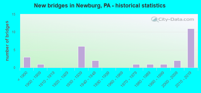
- New bridges - historical statistics
- 3Before 1900
- 11900-1909
- 61930-1939
- 21940-1949
- 11970-1979
- 11980-1989
- 11990-1999
- 22000-2009
- 112010-2019
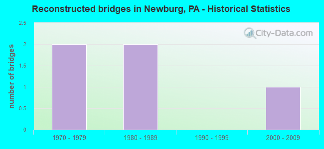
- Reconstructed bridges - Historical Statistics
- 21970-1979
- 21980-1989
- 01990-1999
- 12000-2009
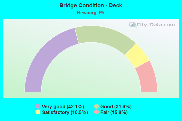
- Bridge Condition - Deck
- 42.1%Very good
- 31.6%Good
- 10.5%Satisfactory
- 15.8%Fair
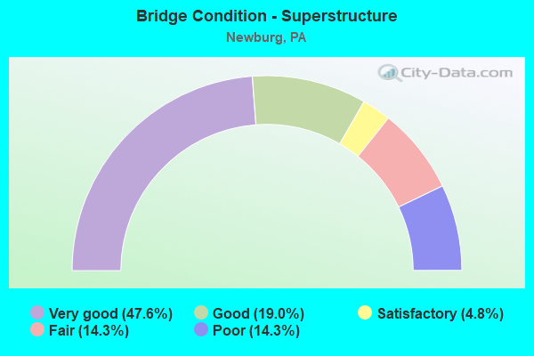
- Bridge Condition - Superstructure
- 47.6%Very good
- 19.0%Good
- 4.8%Satisfactory
- 14.3%Fair
- 14.3%Poor
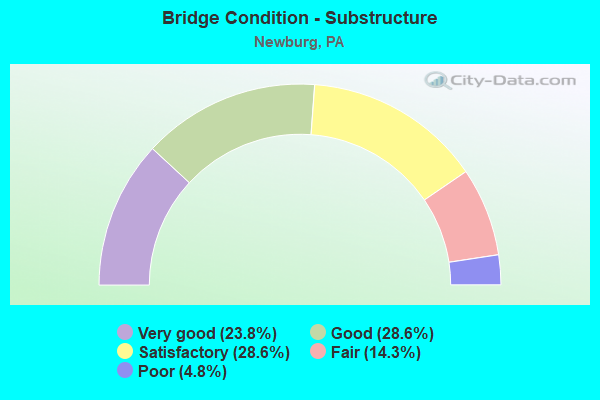
- Bridge Condition - Substructure
- 23.8%Very good
- 28.6%Good
- 28.6%Satisfactory
- 14.3%Fair
- 4.8%Poor
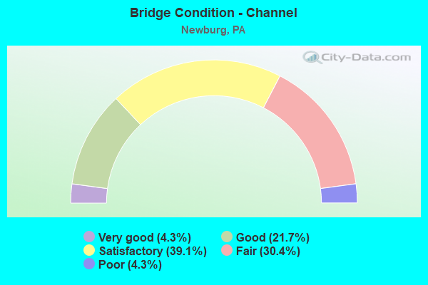
- Bridge Condition - Channel
- 4.3%Very good
- 21.7%Good
- 39.1%Satisfactory
- 30.4%Fair
- 4.3%Poor
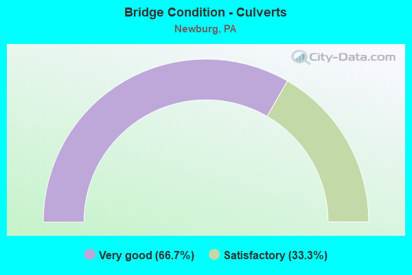
- Bridge Condition - Culverts
- 66.7%Very good
- 33.3%Satisfactory
Find on map >> Show street view
Structure Number: 13769, Location: 1.5 MI.EAST OF NEWBURG (Lat: 40.144433, Lng: -77.518508), Route carried "on" structure: State highway 641, Year Built: 1948, Status: Open, Structure Length: 1.01m (3.31ft), Average Daily Traffic: 2,582 (year 2020), Truck Traffic: 14%, Average Future Daily Traffic: 3,128 (year 2032), Design Load: H 20, Features Intersected: PEEBLES RUN
Minimum Vertical Clearance: 30+ m (98+ ft), Kilometerpoint: 5.095, Lanes on structure: 2, Owner: State Highway Agency, Approaching Roadway Width: 7.3m (24.0ft), Skew: 1 degrees, Material/Design: Steel, Design/Construction: Stringer/Multi-beam, Number Of Spans In Main Unit: 1, Length of Maximum Span: 9.1m (29.9ft), Curb or Sidewalk Widths: Left: 0.2m (0.7ft), Right: 0.2m (0.7ft), Curb-To-Curb Width: 9.1m (29.9ft), Out-to-Out Width: 9.8m (32.2ft)
Condition: Deck: Fair, Superstructure: Fair, Substructure: Satisfactory, Channel: Fair, Operating Rating: 47.2 metric tons, Method Used To Determine Operating Rating: Load Factor (LF), Inventory Rating: 28.1 metric tons, Method Used To Determine Inventory Rating: Load Factor (LF), Structural Evaluation: Somewhat better than minimum adequacy, Deck Geometry: Meets minimum limits, Waterway Adequacy: Better than present minimum criteria, Approach Roadway Alignment: Better than present minimum criteria, Length Of Structure Improvement: 1.60m (5.25ft), Designated Inspection Frequency: Every 24 months, Inspection Date: January 2020, Bridge Improvement Cost: $4,000, Roadway Improvement Cost: $11,000, Total Project Cost: $52,000, Deck Structure Type: Closed Grating, Wearing Surface/Protective System: Wearing Surface: Bituminous, Membrane: Preformed Fabric
Find on map >> Show street view
Structure Number: 13788, Location: HOPEWELL TOWNSHIP (Lat: 40.120664, Lng: -77.544731), Route carried "on" structure: State highway 696, Year Built: 1933, Year Reconstructed: 1977, Status: Open, Structure Length: 2.96m (9.71ft), Average Daily Traffic: 2,770 (year 2020), Truck Traffic: 13%, Average Future Daily Traffic: 4,409 (year 2032), Design Load: HS 20, Features Intersected: CONODOGUINET CREEK
Minimum Vertical Clearance: 30+ m (98+ ft), Kilometerpoint: 9.156, Lanes on structure: 2, Owner: State Highway Agency, Approaching Roadway Width: 7.3m (24.0ft), Material/Design: Steel, Design/Construction: Stringer/Multi-beam, Number Of Spans In Main Unit: 2, Length of Maximum Span: 14.3m (46.9ft), Curb-To-Curb Width: 7.3m (24.0ft), Out-to-Out Width: 8.2m (26.9ft)
Condition: Deck: Satisfactory, Superstructure: Good, Substructure: Poor, Channel: Poor, Operating Rating: 53.5 metric tons, Method Used To Determine Operating Rating: Load Factor (LF), Inventory Rating: 31.8 metric tons, Method Used To Determine Inventory Rating: Load Factor (LF), Structural Evaluation: Meets minimum limits, Deck Geometry: High priority of replacement, Waterway Adequacy: Equal to present desirable criteria, Approach Roadway Alignment: Equal to present desirable criteria, Length Of Structure Improvement: 3.80m (12.47ft), Designated Inspection Frequency: Every 24 months, Underwater Inspection Frequency: Every 24 months, Inspection Date: January 2020, Underwater Inspection Date: August 2021, Bridge Improvement Cost: $86,000, Roadway Improvement Cost: $252,000, Total Project Cost: $1,158,000, Deck Structure Type: Open Grating
Find on map >> Show street view
Structure Number: 13957, Location: 3 MI E OF NEWBURG (Lat: 40.151775, Lng: -77.500342), Route carried "on" structure: State highway , Year Built: 1909, Status: Open, Structure Length: 4.15m (13.62ft), Average Daily Traffic: 303 (year 2021), Truck Traffic: 13%, Average Future Daily Traffic: 313 (year 2032), Features Intersected: CONODOGUINET CREEK, Facility Carried by Structure: SR 4007 MOUNTAIN R
Minimum Vertical Clearance: 30+ m (98+ ft), Kilometerpoint: 0.000, Lanes on structure: 1, Owner: State Highway Agency, Approaching Roadway Width: 4.6m (15.1ft), Material/Design: Concrete, Design/Construction: Arch - Deck, Number Of Spans In Main Unit: 2, Length of Maximum Span: 18.9m (62.0ft), Curb or Sidewalk Widths: Left: 0.1m (0.3ft), Right: 0.1m (0.3ft), Curb-To-Curb Width: 4.1m (13.5ft), Out-to-Out Width: 4.7m (15.4ft)
Condition: Superstructure: Fair, Substructure: Satisfactory, Channel: Good, Operating Rating: 39.0 metric tons, Method Used To Determine Operating Rating: Field evaluation and documented engineering judgment, Inventory Rating: 26.3 metric tons, Method Used To Determine Inventory Rating: Field evaluation and documented engineering judgment, Structural Evaluation: Somewhat better than minimum adequacy, Deck Geometry: High priority of replacement, Waterway Adequacy: Better than present minimum criteria, Approach Roadway Alignment: Equal to present desirable criteria, Length Of Structure Improvement: 5.00m (16.40ft), Designated Inspection Frequency: Every 24 months, Inspection Date: January 2020, Bridge Improvement Cost: $65,000, Roadway Improvement Cost: $190,000, Total Project Cost: $873,000, Wearing Surface/Protective System: Wearing Surface: Bituminous
Find on map >> Show street view
Structure Number: 13959, Location: 2 MI N OF HEBERLIG (Lat: 40.178878, Lng: -77.528731), Route carried "on" structure: State highway , Year Built: 1937, Year Reconstructed: 1987, Status: Open, Structure Length: 1.16m (3.81ft), Average Daily Traffic: 303 (year 2021), Truck Traffic: 13%, Average Future Daily Traffic: 313 (year 2032), Design Load: HS 25 or greater, Features Intersected: THREE SQUARE HOLLOW CK, Facility Carried by Structure: 4007-Mountain Rd
Minimum Vertical Clearance: 30+ m (98+ ft), Kilometerpoint: 4.577, Lanes on structure: 2, Owner: State Highway Agency, Approaching Roadway Width: 4.9m (16.1ft), Skew: 1 degrees, Material/Design: Prestressed concrete, Design/Construction: Box Beam or Girders - Single/Spread, Number Of Spans In Main Unit: 1, Length of Maximum Span: 11.0m (36.1ft), Curb or Sidewalk Widths: Left: 0.2m (0.7ft), Right: 0.2m (0.7ft), Curb-To-Curb Width: 6.7m (22.0ft), Out-to-Out Width: 7.5m (24.6ft)
Condition: Deck: Good, Superstructure: Very good, Substructure: Satisfactory, Channel: Satisfactory, Operating Rating: 88.9 metric tons, Method Used To Determine Operating Rating: Load Factor (LF), Inventory Rating: 42.6 metric tons, Method Used To Determine Inventory Rating: Load Factor (LF), Structural Evaluation: Equal to present minimum criteria, Deck Geometry: Meets minimum limits, Waterway Adequacy: Better than present minimum criteria, Approach Roadway Alignment: Equal to present desirable criteria, Length Of Structure Improvement: 1.80m (5.91ft), Designated Inspection Frequency: Every 24 months, Inspection Date: January 2020, Deck Structure Type: Concrete Cast-file-Place, Wearing Surface/Protective System: Wearing Surface: Monolithic Concrete, Deck Protection: Epoxy Coated Reinforcing
Find on map >> Show street view
Structure Number: 13977, Location: UPPER MIFFLIN TWP (Lat: 40.176831, Lng: -77.528481), Route carried "on" structure: Interstate 76, Year Built: 1938, Status: Open, Structure Length: 0.73m (2.40ft), Average Daily Traffic: 21,102 (year 2001), Truck Traffic: 38%, Average Future Daily Traffic: 23,285 (year 2030), Design Load: HS 20, Features Intersected: THREE SQUARE HOLLOW RUN
Minimum Vertical Clearance: 30+ m (98+ ft), Kilometerpoint: 0.000, Lanes on structure: 4, Base Highway Network: Yes, Toll: On toll road, Owner: State Toll Authority, Approaching Roadway Width: 23.8m (78.1ft), Skew: 30 degrees, Material/Design: Concrete, Design/Construction: Culvert, Number Of Spans In Main Unit: 1, Length of Maximum Span: 7.3m (24.0ft)
Condition: Channel: Fair, Culverts: Satisfactory, Operating Rating: 89.8 metric tons, Method Used To Determine Operating Rating: Load Factor (LF), Inventory Rating: 89.8 metric tons, Method Used To Determine Inventory Rating: Load Factor (LF), Structural Evaluation: Equal to present minimum criteria, Waterway Adequacy: Superior to present desirable criteria, Approach Roadway Alignment: Equal to present desirable criteria, Length Of Structure Improvement: 1.60m (5.25ft), Designated Inspection Frequency: Every 48 months, Inspection Date: January 2019, Bridge Improvement Cost: $27,000, Roadway Improvement Cost: $78,000, Total Project Cost: $359,000
Find on map >> Show street view
Structure Number: 14062, Location: 1.5 S NEWBURG/PAXTON RUN (Lat: 40.116358, Lng: -77.559319), Route carried "on" structure: City street , Year Built: 1940, Year Reconstructed: 1986, Status: Open, Structure Length: 0.85m (2.79ft), Average Daily Traffic: 50 (year 2021), Truck Traffic: 5%, Average Future Daily Traffic: 100 (year 2041), Features Intersected: PAXTON RUN, Facility Carried by Structure: SHADY ROAD, T-362
Minimum Vertical Clearance: 30+ m (98+ ft), Kilometerpoint: 0.000, Lanes on structure: 2, Owner: Town or Township Highway Agency, Approaching Roadway Width: 8.2m (26.9ft), Material/Design: Concrete continuous, Design/Construction: Slab, Number Of Spans In Main Unit: 2, Length of Maximum Span: 4.0m (13.1ft), Curb-To-Curb Width: 7.8m (25.6ft), Out-to-Out Width: 8.3m (27.2ft)
Condition: Deck: Good, Superstructure: Good, Substructure: Fair, Channel: Fair, Operating Rating: 61.7 metric tons, Method Used To Determine Operating Rating: Field evaluation and documented engineering judgment, Inventory Rating: 37.2 metric tons, Method Used To Determine Inventory Rating: Field evaluation and documented engineering judgment, Structural Evaluation: Somewhat better than minimum adequacy, Deck Geometry: Equal to present minimum criteria, Waterway Adequacy: Equal to present minimum criteria, Approach Roadway Alignment: Better than present minimum criteria, Length Of Structure Improvement: 1.60m (5.25ft), Designated Inspection Frequency: Every 24 months, Inspection Date: June 2021, Deck Structure Type: Concrete Cast-file-Place, Wearing Surface/Protective System: Wearing Surface: Bituminous
Find on map >> Show street view
Structure Number: 14063, Location: 2E NEWBURG/HOPEWELL TWP. (Lat: 40.136336, Lng: -77.523517), Route carried "on" structure: City street , Year Built: 1870, Status: Closed, Structure Length: 3.51m (11.52ft), Average Daily Traffic: 248 (year 2019), Truck Traffic: 5%, Average Future Daily Traffic: 284 (year 2039), Design Load: HS 20, Features Intersected: CONODOGUINET CREEK, Facility Carried by Structure: T-374, RAMP BRIDGE
Minimum Vertical Clearance: 3.40m (11.15ft), Kilometerpoint: 0.000, Lanes on structure: 1, Owner: County Highway Agency, Approaching Roadway Width: 4.6m (15.1ft), Material/Design: Wood or Timber, Design/Construction: Truss - Thru, Number Of Spans In Main Unit: 1, Length of Maximum Span: 33.5m (109.9ft), Curb-To-Curb Width: 4.6m (15.1ft), Out-to-Out Width: 4.6m (15.1ft)
Condition: Deck: Very good, Superstructure: Poor, Substructure: Satisfactory, Channel: Fair, Operating Rating: 4.5 metric tons, Method Used To Determine Operating Rating: Allowable Stress (AS), Inventory Rating: 3.6 metric tons, Method Used To Determine Inventory Rating: Allowable Stress (AS), Waterway Adequacy: Better than present minimum criteria, Approach Roadway Alignment: Meets minimum limits, Bridge Posting: Required (Relationship of Operating Rating to Maximum Legal Load: > 39.9% below), Length Of Structure Improvement: 4.40m (14.44ft), Designated Inspection Frequency: Every 24 months, Other Special Inspection Frequency: Every 12 months, Inspection Date: June 2021, Other Special Inspection Date: June 2021, Bridge Improvement Cost: $16,000, Roadway Improvement Cost: $48,000, Total Project Cost: $218,000, Deck Structure Type: Wood or Timber, Wearing Surface/Protective System: Wearing Surface: Wood or Timber
Find on map >> Show street view
Structure Number: 17441, Location: 3.5 MI E OF ROXBURY (Lat: 40.123469, Lng: -77.598600), Route carried "on" structure: State highway 641, Year Built: 1933, Year Reconstructed: 2009, Status: Open, Structure Length: 0.79m (2.59ft), Average Daily Traffic: 1,254 (year 2022), Truck Traffic: 15%, Average Future Daily Traffic: 1,823 (year 2032), Design Load: H 20, Features Intersected: CLIPPINGER RUN
Minimum Vertical Clearance: 30+ m (98+ ft), Kilometerpoint: 24.583, Lanes on structure: 2, Owner: State Highway Agency, Approaching Roadway Width: 7.3m (24.0ft), Material/Design: Steel, Design/Construction: Stringer/Multi-beam, Number Of Spans In Main Unit: 1, Length of Maximum Span: 7.3m (24.0ft), Curb-To-Curb Width: 7.4m (24.3ft), Out-to-Out Width: 8.2m (26.9ft)
Condition: Deck: Good, Superstructure: Very good, Substructure: Good, Channel: Satisfactory, Operating Rating: 69.9 metric tons, Method Used To Determine Operating Rating: Load Factor (LF), Inventory Rating: 41.7 metric tons, Method Used To Determine Inventory Rating: Load Factor (LF), Structural Evaluation: Better than present minimum criteria, Deck Geometry: Meets minimum limits, Waterway Adequacy: Better than present minimum criteria, Approach Roadway Alignment: Equal to present minimum criteria, Length Of Structure Improvement: 1.40m (4.59ft), Designated Inspection Frequency: Every 24 months, Inspection Date: July 2020, Bridge Improvement Cost: $30,000, Roadway Improvement Cost: $87,000, Total Project Cost: $400,000, Deck Structure Type: Concrete Cast-file-Place, Wearing Surface/Protective System: Wearing Surface: Monolithic Concrete, Deck Protection: Epoxy Coated Reinforcing
Find on map >> Show street view
Structure Number: 17442, Location: 4 MI.E. OF ROXBURY (Lat: 40.131233, Lng: -77.579161), Route carried "on" structure: State highway 641, Year Built: 1932, Year Reconstructed: 1983, Status: Open, Structure Length: 1.04m (3.41ft), Average Daily Traffic: 1,254 (year 2022), Truck Traffic: 15%, Average Future Daily Traffic: 1,823 (year 2032), Design Load: HS 20+Mod, Features Intersected: LAUGHLIN RUN
Minimum Vertical Clearance: 30+ m (98+ ft), Kilometerpoint: 25.991, Lanes on structure: 2, Owner: State Highway Agency, Approaching Roadway Width: 7.3m (24.0ft), Skew: 3 degrees, Material/Design: Steel, Design/Construction: Stringer/Multi-beam, Number Of Spans In Main Unit: 1, Length of Maximum Span: 9.1m (29.9ft), Curb or Sidewalk Widths: Left: 0.2m (0.7ft), Right: 0.2m (0.7ft), Curb-To-Curb Width: 8.5m (27.9ft), Out-to-Out Width: 9.6m (31.5ft)
Condition: Deck: Satisfactory, Superstructure: Satisfactory, Substructure: Satisfactory, Channel: Satisfactory, Operating Rating: 55.3 metric tons, Method Used To Determine Operating Rating: Load Factor (LF), Inventory Rating: 32.7 metric tons, Method Used To Determine Inventory Rating: Load Factor (LF), Structural Evaluation: Equal to present minimum criteria, Deck Geometry: Somewhat better than minimum adequacy, Waterway Adequacy: Better than present minimum criteria, Approach Roadway Alignment: Equal to present desirable criteria, Length Of Structure Improvement: 1.70m (5.58ft), Designated Inspection Frequency: Every 24 months, Inspection Date: April 2020, Deck Structure Type: Concrete Cast-file-Place, Wearing Surface/Protective System: Wearing Surface: Monolithic Concrete, Deck Protection: Epoxy Coated Reinforcing
Find on map >> Show street view
Structure Number: 17608, Location: 1 MI S.E. OF MOWERSVILLE (Lat: 40.103917, Lng: -77.576250), Route carried "on" structure: State highway , Year Built: 1937, Status: Open, Structure Length: 0.91m (2.99ft), Average Daily Traffic: 357 (year 2020), Truck Traffic: 12%, Average Future Daily Traffic: 423 (year 2032), Design Load: H 20, Features Intersected: TR CONODOGUINET CREEK, Facility Carried by Structure: SR 4018;Paxton Run
Minimum Vertical Clearance: 30+ m (98+ ft), Kilometerpoint: 0.035, Lanes on structure: 2, Owner: State Highway Agency, Approaching Roadway Width: 6.1m (20.0ft), Skew: 3 degrees, Material/Design: Concrete, Design/Construction: Tee Beam, Number Of Spans In Main Unit: 1, Length of Maximum Span: 7.9m (25.9ft), Curb or Sidewalk Widths: Left: 0.2m (0.7ft), Right: 0.2m (0.7ft), Curb-To-Curb Width: 7.1m (23.3ft), Out-to-Out Width: 7.9m (25.9ft)
Condition: Deck: Fair, Superstructure: Fair, Substructure: Fair, Channel: Satisfactory, Operating Rating: 52.6 metric tons, Method Used To Determine Operating Rating: Load Factor (LF), Inventory Rating: 31.8 metric tons, Method Used To Determine Inventory Rating: Load Factor (LF), Structural Evaluation: Somewhat better than minimum adequacy, Deck Geometry: Meets minimum limits, Waterway Adequacy: Better than present minimum criteria, Approach Roadway Alignment: Equal to present desirable criteria, Length Of Structure Improvement: 1.60m (5.25ft), Designated Inspection Frequency: Every 24 months, Inspection Date: May 2020, Deck Structure Type: Concrete Cast-file-Place, Wearing Surface/Protective System: Wearing Surface: Bituminous
Find on map >> Show street view
Structure Number: 17609, Location: 1.5 MI SE OF MOWERSVILLE (Lat: 40.096903, Lng: -77.570825), Route carried "on" structure: State highway , Year Built: 1827, Status: Open, Structure Length: 1.37m (4.49ft), Average Daily Traffic: 359 (year 2021), Truck Traffic: 4%, Average Future Daily Traffic: 689 (year 2032), Features Intersected: TRIB CONODOGUINET CR, Facility Carried by Structure: SR 4018 McClays Ml
Minimum Vertical Clearance: 30+ m (98+ ft), Kilometerpoint: 0.045, Lanes on structure: 2, Owner: State Highway Agency, Approaching Roadway Width: 6.1m (20.0ft), Material/Design: Masonry, Design/Construction: Arch - Deck, Number Of Spans In Main Unit: 2, Length of Maximum Span: 6.1m (20.0ft), Curb-To-Curb Width: 5.1m (16.7ft), Out-to-Out Width: 6.2m (20.3ft)
Condition: Superstructure: Poor, Substructure: Fair, Channel: Satisfactory, Operating Rating: 39.0 metric tons, Method Used To Determine Operating Rating: Field evaluation and documented engineering judgment, Inventory Rating: 26.3 metric tons, Method Used To Determine Inventory Rating: Field evaluation and documented engineering judgment, Structural Evaluation: Meets minimum limits, Deck Geometry: High priority of replacement, Waterway Adequacy: Better than present minimum criteria, Approach Roadway Alignment: Equal to present desirable criteria, Length Of Structure Improvement: 2.10m (6.89ft), Designated Inspection Frequency: Every 24 months, Other Special Inspection Frequency: Every 12 months, Inspection Date: April 2020, Other Special Inspection Date: April 2021, Bridge Improvement Cost: $35,000, Roadway Improvement Cost: $103,000, Total Project Cost: $473,000
Find on map >> Show street view
Structure Number: 17679, Location: 2.3 MI SE OF SR 641 (Lat: 40.104472, Lng: -77.560653), Route carried "on" structure: City street , Year Built: 1885, Status: Posted for load, Structure Length: 3.32m (10.89ft), Average Daily Traffic: 250 (year 2009), Average Future Daily Traffic: 270 (year 2029), Design Load: H 10, Features Intersected: CONODOGUINET CREEK, Facility Carried by Structure: BURNT MILL ROAD
Minimum Vertical Clearance: 4.11m (13.48ft), Kilometerpoint: 0.000, Lanes on structure: 1, Owner: County Highway Agency, Approaching Roadway Width: 5.5m (18.0ft), Skew: 2 degrees, Material/Design: Aluminum, Iron, Design/Construction: Truss - Thru, Number Of Spans In Main Unit: 1, Length of Maximum Span: 32.0m (105.0ft), Curb-To-Curb Width: 4.4m (14.4ft), Out-to-Out Width: 4.7m (15.4ft)
Condition: Deck: Fair, Superstructure: Poor, Substructure: Satisfactory, Channel: Good, Operating Rating: 6.4 metric tons, Method Used To Determine Operating Rating: Allowable Stress (AS), Inventory Rating: 4.5 metric tons, Method Used To Determine Inventory Rating: Allowable Stress (AS), Structural Evaluation: High priority of corrective action, Deck Geometry: High priority of replacement, Waterway Adequacy: Equal to present desirable criteria, Approach Roadway Alignment: Meets minimum limits, Bridge Posting: Required (Relationship of Operating Rating to Maximum Legal Load: > 39.9% below), Length Of Structure Improvement: 3.30m (10.83ft), Designated Inspection Frequency: Every 24 months, Critical Feature Inspection Frequency: Every 12 months, Other Special Inspection Frequency: Every 12 months, Inspection Date: December 2019, Critical Feature Inspection Date: December 2020, Other Special Inspection Date: December 2020, Bridge Improvement Cost: $11,000, Roadway Improvement Cost: $34,000, Total Project Cost: $153,000, Deck Structure Type: Wood or Timber, Wearing Surface/Protective System: Wearing Surface: Wood or Timber
Find on map >> Show street view
Structure Number: 17682, Location: 1.22 MI. SW OF SR 696 (Lat: 40.116444, Lng: -77.564528), Route carried "on" structure: City street , Year Built: 1978, Status: Open, Structure Length: 1.31m (4.30ft), Average Daily Traffic: 200 (year 2009), Truck Traffic: 10%, Average Future Daily Traffic: 280 (year 2029), Design Load: HS 20, Features Intersected: PAXTON RUN, Facility Carried by Structure: T-646 W. CREEK RD
Minimum Vertical Clearance: 30+ m (98+ ft), Kilometerpoint: 0.000, Lanes on structure: 2, Owner: County Highway Agency, Approaching Roadway Width: 6.1m (20.0ft), Skew: 1 degrees, Material/Design: Prestressed concrete, Design/Construction: Box Beam or Girders - Single/Spread, Number Of Spans In Main Unit: 1, Length of Maximum Span: 12.8m (42.0ft), Curb-To-Curb Width: 8.5m (27.9ft), Out-to-Out Width: 9.6m (31.5ft)
Condition: Deck: Good, Superstructure: Good, Substructure: Good, Channel: Good, Operating Rating: 48.1 metric tons, Method Used To Determine Operating Rating: Load Factor (LF), Inventory Rating: 29.0 metric tons, Method Used To Determine Inventory Rating: Load Factor (LF), Structural Evaluation: Better than present minimum criteria, Deck Geometry: Equal to present minimum criteria, Waterway Adequacy: Equal to present desirable criteria, Approach Roadway Alignment: Equal to present desirable criteria, Length Of Structure Improvement: 2.00m (6.56ft), Designated Inspection Frequency: Every 24 months, Inspection Date: October 2019, Deck Structure Type: Concrete Cast-file-Place, Wearing Surface/Protective System: Wearing Surface: Monolithic Concrete
Find on map >> Show street view
Structure Number: 40623, Location: Newville Rd (Lat: 40.131217, Lng: -77.579167), Route carried "on" structure: State highway 641, Year Built: 1999, Status: Open, Structure Length: 0.64m (2.10ft), Average Daily Traffic: 5,361 (year 2022), Truck Traffic: 7%, Average Future Daily Traffic: 8,175 (year 2032), Design Load: HS 25 or greater, Features Intersected: ALEXANDER SPRING CREEK
Minimum Vertical Clearance: 30+ m (98+ ft), Kilometerpoint: 29.828, Lanes on structure: 2, Base Highway Network: Yes, Owner: State Highway Agency, Approaching Roadway Width: 9.1m (29.9ft), Skew: 1 degrees, Material/Design: Concrete, Design/Construction: Culvert, Number Of Spans In Main Unit: 1, Length of Maximum Span: 6.4m (21.0ft), Curb-To-Curb Width: 9.8m (32.2ft), Out-to-Out Width: 10.9m (35.8ft)
Condition: Channel: Satisfactory, Culverts: Very good, Operating Rating: 85.3 metric tons, Method Used To Determine Operating Rating: Load Factor (LF), Inventory Rating: 50.8 metric tons, Method Used To Determine Inventory Rating: Load Factor (LF), Structural Evaluation: Equal to present desirable criteria, Deck Geometry: Meets minimum limits, Waterway Adequacy: Superior to present desirable criteria, Approach Roadway Alignment: Equal to present desirable criteria, Length Of Structure Improvement: 1.30m (4.27ft), Designated Inspection Frequency: Every 24 months, Inspection Date: Febuary 2020, Wearing Surface/Protective System: Wearing Surface: Bituminous, Membrane: Preformed Fabric
Find on map >> Show street view
Structure Number: 43481, Location: 3.5 MI EAST OF NEWBURG (Lat: 40.161806, Lng: -77.507694), Route carried "on" structure: State highway , Year Built: 2006, Status: Open, Structure Length: 1.62m (5.31ft), Average Daily Traffic: 303 (year 2021), Truck Traffic: 13%, Average Future Daily Traffic: 313 (year 2032), Design Load: HL 93, Features Intersected: THREE SQUARE HOLLOW CK, Facility Carried by Structure: SR 4007 MOUNTAIN R
Minimum Vertical Clearance: 30+ m (98+ ft), Kilometerpoint: 1.690, Lanes on structure: 2, Owner: State Highway Agency, Approaching Roadway Width: 8.5m (27.9ft), Material/Design: Prestressed concrete, Design/Construction: Box Beam or Girders - Single/Spread, Number Of Spans In Main Unit: 1, Length of Maximum Span: 15.8m (51.8ft), Curb or Sidewalk Widths: Left: 0.2m (0.7ft), Right: 0.2m (0.7ft), Curb-To-Curb Width: 8.5m (27.9ft), Out-to-Out Width: 9.6m (31.5ft)
Condition: Deck: Good, Superstructure: Very good, Substructure: Good, Channel: Satisfactory, Operating Rating: 61.7 metric tons, Method Used To Determine Operating Rating: Load and Resistance Factor (LRFR), Inventory Rating: 36.3 metric tons, Method Used To Determine Inventory Rating: Load and Resistance Factor (LRFR), Structural Evaluation: Better than present minimum criteria, Deck Geometry: Equal to present minimum criteria, Waterway Adequacy: Better than present minimum criteria, Approach Roadway Alignment: Equal to present desirable criteria, Designated Inspection Frequency: Every 24 months, Inspection Date: January 2020, Deck Structure Type: Concrete Cast-file-Place, Wearing Surface/Protective System: Wearing Surface: Monolithic Concrete, Deck Protection: Epoxy Coated Reinforcing
Find on map >> Show street view
Structure Number: 46334, Location: HOPEWELL TWP (Lat: 40.170850, Lng: -77.563981), Route carried "on" structure: City street T379, Year Built: 2009, Status: Open, Structure Length: 4.85m (15.91ft), Average Daily Traffic: 542 (year 2011), Truck Traffic: 9%, Average Future Daily Traffic: 680 (year 2030), Design Load: HL 93, Features Intersected: PA TPK (I-76), Facility Carried by Structure: T-379
Minimum Vertical Clearance: 30+ m (98+ ft), Kilometerpoint: 0.000, Lanes on structure: 2, Lanes under structure: 6, Owner: State Toll Authority, Approaching Roadway Width: 9.1m (29.9ft), Material/Design: Steel continuous, Design/Construction: Stringer/Multi-beam, Number Of Spans In Main Unit: 2, Length of Maximum Span: 23.8m (78.1ft), Curb or Sidewalk Widths: Left: 0.1m (0.3ft), Right: 0.1m (0.3ft), Curb-To-Curb Width: 9.1m (29.9ft), Out-to-Out Width: 10.2m (33.5ft)
Condition: Deck: Very good, Superstructure: Good, Substructure: Good, Operating Rating: 84.4 metric tons, Method Used To Determine Operating Rating: Load and Resistance Factor (LRFR), Inventory Rating: 64.4 metric tons, Method Used To Determine Inventory Rating: Load and Resistance Factor (LRFR), Structural Evaluation: Better than present minimum criteria, Deck Geometry: Equal to present minimum criteria, Underclear: Better than present minimum criteria, Approach Roadway Alignment: Equal to present desirable criteria, Designated Inspection Frequency: Every 48 months, Inspection Date: January 2019, Deck Structure Type: Concrete Cast-file-Place, Wearing Surface/Protective System: Wearing Surface: Monolithic Concrete, Deck Protection: Epoxy Coated Reinforcing
Find on map >> Show street view
Structure Number: 47728, Location: Lurgan Twp (Lat: 40.158489, Lng: -77.614300), Route carried "on" structure: Ramp Other road 76, Year Built: 2012, Status: Open, Structure Length: 4.88m (16.01ft), Average Daily Traffic: 833 (year 2010), Truck Traffic: 24%, Average Future Daily Traffic: 1,000 (year 2030), Design Load: HS 20, Features Intersected: PA TPK (I-76), Facility Carried by Structure: Turnpike Ramp
Minimum Vertical Clearance: 30+ m (98+ ft), Kilometerpoint: 0.000, Lanes on structure: 2, Lanes under structure: 7, Base Highway Network: Yes, Toll: On toll road, Owner: State Toll Authority, Approaching Roadway Width: 16.5m (54.1ft), Skew: 31 degrees, Material/Design: Concrete continuous, Design/Construction: Box Beam or Girders - Single/Spread, Number Of Spans In Main Unit: 2, Length of Maximum Span: 24.4m (80.1ft), Curb or Sidewalk Widths: Left: 0.2m (0.7ft), Right: 0.2m (0.7ft), Curb-To-Curb Width: 15.8m (51.8ft), Out-to-Out Width: 19.8m (65.0ft)
Condition: Deck: Good, Superstructure: Very good, Substructure: Good, Inventory Rating: 35.4 metric tons, Method Used To Determine Inventory Rating: Assigned ratings based on Load and Resistance Factor Design (LRFD) reported in metric tons, Structural Evaluation: Better than present minimum criteria, Deck Geometry: Superior to present desirable criteria, Underclear: Equal to present desirable criteria, Approach Roadway Alignment: Equal to present desirable criteria, Designated Inspection Frequency: Every 24 months, Inspection Date: January 2021, Deck Structure Type: Concrete Cast-file-Place, Wearing Surface/Protective System: Wearing Surface: Monolithic Concrete, Membrane: Other, Deck Protection: Epoxy Coated Reinforcing
Find on map >> Show street view
Structure Number: 52656, Location: 0.3 MI WEST OF LR 21062 (Lat: 40.144083, Lng: -77.516889), Route carried "on" structure: State highway 641, Year Built: 2015, Status: Open, Structure Length: 9.20m (30.18ft), Average Daily Traffic: 2,582 (year 2020), Truck Traffic: 14%, Average Future Daily Traffic: 3,128 (year 2032), Design Load: HL 93, Features Intersected: Conodoguinet Creek
Minimum Vertical Clearance: 30+ m (98+ ft), Kilometerpoint: 5.095, Lanes on structure: 2, Owner: State Highway Agency, Approaching Roadway Width: 7.9m (25.9ft), Skew: 4 degrees, Material/Design: Prestressed concrete continuous, Design/Construction: Box Beam or Girders - Single/Spread, Number Of Spans In Main Unit: 4, Length of Maximum Span: 21.9m (71.9ft), Curb or Sidewalk Widths: Left: 0.2m (0.7ft), Right: 0.2m (0.7ft), Curb-To-Curb Width: 11.0m (36.1ft), Out-to-Out Width: 12.0m (39.4ft)
Condition: Deck: Very good, Superstructure: Very good, Substructure: Very good, Channel: Fair, Operating Rating: 52.8 metric tons, Method Used To Determine Operating Rating: Assigned ratings based on Load and Resistance Factor Design (LRFD) reported by rating factor (RF) using HL93 loadings, Inventory Rating: 33.4 metric tons, Method Used To Determine Inventory Rating: Assigned ratings based on Load and Resistance Factor Design (LRFD) reported by rating factor (RF) using HL93 loadings, Structural Evaluation: Equal to present desirable criteria, Deck Geometry: Somewhat better than minimum adequacy, Waterway Adequacy: Better than present minimum criteria, Approach Roadway Alignment: Equal to present desirable criteria, Designated Inspection Frequency: Every 24 months, Inspection Date: September 2021, Deck Structure Type: Concrete Cast-file-Place, Wearing Surface/Protective System: Wearing Surface: Monolithic Concrete, Membrane: Epoxy, Deck Protection: Epoxy Coated Reinforcing
Find on map >> Show street view
Structure Number: 54649, Location: Hopewell Twp. (Lat: 40.174106, Lng: -77.545156), Route carried "on" structure: State highway 997, Year Built: 2017, Status: Open, Structure Length: 6.89m (22.60ft), Average Daily Traffic: 716 (year 2021), Truck Traffic: 14%, Average Future Daily Traffic: 732 (year 2038), Design Load: HL 93, Features Intersected: PA TPK (I-76)
Minimum Vertical Clearance: 30+ m (98+ ft), Kilometerpoint: 6.159, Lanes on structure: 2, Lanes under structure: 6, Owner: State Highway Agency, Approaching Roadway Width: 9.8m (32.2ft), Skew: 4 degrees, Material/Design: Prestressed concrete continuous, Design/Construction: Box Beam or Girders - Single/Spread, Number Of Spans In Main Unit: 2, Length of Maximum Span: 33.8m (110.9ft), Curb or Sidewalk Widths: Left: 0.2m (0.7ft), Right: 0.2m (0.7ft), Curb-To-Curb Width: 9.8m (32.2ft), Out-to-Out Width: 10.8m (35.4ft)
Condition: Deck: Very good, Superstructure: Very good, Substructure: Very good, Operating Rating: 44.4 metric tons, Method Used To Determine Operating Rating: Assigned ratings based on Load and Resistance Factor Design (LRFD) reported by rating factor (RF) using HL93 loadings, Inventory Rating: 34.0 metric tons, Method Used To Determine Inventory Rating: Assigned ratings based on Load and Resistance Factor Design (LRFD) reported by rating factor (RF) using HL93 loadings, Structural Evaluation: Equal to present desirable criteria, Deck Geometry: Equal to present minimum criteria, Underclear: Equal to present desirable criteria, Approach Roadway Alignment: Equal to present desirable criteria, Designated Inspection Frequency: Every 48 months, Inspection Date: October 2019, Deck Structure Type: Concrete Cast-file-Place, Wearing Surface/Protective System: Wearing Surface: Monolithic Concrete, Deck Protection: Epoxy Coated Reinforcing
Find on map >> Show street view
Structure Number: 5465, Location: Hopewell Twp. (Lat: 40.175061, Lng: -77.542722), Route carried "on" structure: State highway 997, Year Built: 2017, Status: Open, Structure Length: 3.11m (10.20ft), Average Daily Traffic: 716 (year 2021), Truck Traffic: 14%, Average Future Daily Traffic: 732 (year 2038), Design Load: HL 93, Features Intersected: Bore Mill Run
Minimum Vertical Clearance: 30+ m (98+ ft), Kilometerpoint: 6.159, Lanes on structure: 2, Owner: State Highway Agency, Approaching Roadway Width: 9.8m (32.2ft), Material/Design: Prestressed concrete, Design/Construction: Stringer/Multi-beam, Number Of Spans In Main Unit: 1, Length of Maximum Span: 30.5m (100.1ft), Curb or Sidewalk Widths: Left: 0.2m (0.7ft), Right: 0.2m (0.7ft), Curb-To-Curb Width: 11.0m (36.1ft), Out-to-Out Width: 12.0m (39.4ft)
Condition: Deck: Very good, Superstructure: Very good, Substructure: Very good, Channel: Very good, Operating Rating: 55.4 metric tons, Method Used To Determine Operating Rating: Assigned ratings based on Load and Resistance Factor Design (LRFD) reported by rating factor (RF) using HL93 loadings, Inventory Rating: 41.1 metric tons, Method Used To Determine Inventory Rating: Assigned ratings based on Load and Resistance Factor Design (LRFD) reported by rating factor (RF) using HL93 loadings, Structural Evaluation: Equal to present desirable criteria, Deck Geometry: Better than present minimum criteria, Waterway Adequacy: Superior to present desirable criteria, Approach Roadway Alignment: Equal to present desirable criteria, Designated Inspection Frequency: Every 48 months, Inspection Date: October 2019, Deck Structure Type: Concrete Cast-file-Place, Wearing Surface/Protective System: Wearing Surface: Monolithic Concrete, Deck Protection: Epoxy Coated Reinforcing
Find on map >> Show street view
Structure Number: 54747, Location: 1.2 MI NW OF NEWBURG (Lat: 40.148528, Lng: -77.572889), Route carried "on" structure: State highway 696, Year Built: 2018, Status: Open, Structure Length: 0.64m (2.10ft), Average Daily Traffic: 1,402 (year 2022), Truck Traffic: 34%, Average Future Daily Traffic: 2,598 (year 2032), Design Load: HL 93, Features Intersected: TRIB NEWBURG RUN
Minimum Vertical Clearance: 30+ m (98+ ft), Kilometerpoint: 13.057, Lanes on structure: 2, Owner: State Highway Agency, Maintenance Responsibility: Private, Approaching Roadway Width: 7.3m (24.0ft), Skew: 4 degrees, Material/Design: Concrete, Design/Construction: Culvert, Number Of Spans In Main Unit: 1, Length of Maximum Span: 6.4m (21.0ft), Curb-To-Curb Width: 12.2m (40.0ft), Out-to-Out Width: 13.6m (44.6ft)
Condition: Channel: Satisfactory, Culverts: Very good, Operating Rating: 76.8 metric tons, Method Used To Determine Operating Rating: Assigned ratings based on Load and Resistance Factor Design (LRFD) reported by rating factor (RF) using HL93 loadings, Inventory Rating: 48.3 metric tons, Method Used To Determine Inventory Rating: Assigned ratings based on Load and Resistance Factor Design (LRFD) reported by rating factor (RF) using HL93 loadings, Structural Evaluation: Equal to present desirable criteria, Deck Geometry: Better than present minimum criteria, Waterway Adequacy: Superior to present desirable criteria, Approach Roadway Alignment: Equal to present desirable criteria, Designated Inspection Frequency: Every 24 months, Inspection Date: November 2021
Find on map >> Show street view
Structure Number: 54749, Location: NEWBURG (Lat: 40.136611, Lng: -77.557667), Route carried "on" structure: State highway 641, Year Built: 2018, Status: Open, Structure Length: 0.94m (3.08ft), Average Daily Traffic: 1,254 (year 2022), Truck Traffic: 15%, Average Future Daily Traffic: 1,825 (year 2032), Design Load: HL 93, Features Intersected: NEWBURG RUN, Facility Carried by Structure: West Main Street
Minimum Vertical Clearance: 30+ m (98+ ft), Kilometerpoint: 0.951, Lanes on structure: 2, Owner: State Highway Agency, Maintenance Responsibility: Private, Approaching Roadway Width: 9.1m (29.9ft), Skew: 1 degrees, Material/Design: Concrete, Design/Construction: Culvert, Number Of Spans In Main Unit: 1, Length of Maximum Span: 9.4m (30.8ft), Curb-To-Curb Width: 12.2m (40.0ft), Out-to-Out Width: 13.3m (43.6ft)
Condition: Channel: Satisfactory, Culverts: Very good, Operating Rating: 47.3 metric tons, Method Used To Determine Operating Rating: Assigned ratings based on Load and Resistance Factor Design (LRFD) reported by rating factor (RF) using HL93 loadings, Inventory Rating: 36.0 metric tons, Method Used To Determine Inventory Rating: Assigned ratings based on Load and Resistance Factor Design (LRFD) reported by rating factor (RF) using HL93 loadings, Structural Evaluation: Equal to present desirable criteria, Deck Geometry: Better than present minimum criteria, Waterway Adequacy: Superior to present desirable criteria, Approach Roadway Alignment: Equal to present desirable criteria, Designated Inspection Frequency: Every 24 months, Inspection Date: November 2020, Wearing Surface/Protective System: Wearing Surface: Bituminous, Membrane: Preformed Fabric
Find on map >> Show street view
Structure Number: 56047, Location: HOPEWELL TWP (Lat: 40.175389, Lng: -77.537444), Route carried "on" structure: Interstate 76, Year Built: 2018, Status: Open, Structure Length: 1.04m (3.41ft), Average Daily Traffic: 21,102 (year 2001), Truck Traffic: 38%, Average Future Daily Traffic: 23,285 (year 2030), Design Load: HL 93, Features Intersected: Bore Mill Run
Minimum Vertical Clearance: 30+ m (98+ ft), Kilometerpoint: 331.026, Lanes on structure: 6, Base Highway Network: Yes, Toll: On toll road, Owner: State Toll Authority, Approaching Roadway Width: 35.1m (115.2ft), Skew: 33 degrees, Material/Design: Prestressed concrete, Design/Construction: Box Beam or Girders - Single/Spread, Number Of Spans In Main Unit: 1, Length of Maximum Span: 9.8m (32.2ft), Curb or Sidewalk Widths: Left: 0.2m (0.7ft), Right: 0.2m (0.7ft), Curb-To-Curb Width: 17.5m (57.4ft), Out-to-Out Width: 37.0m (121.4ft)
Condition: Deck: Very good, Superstructure: Very good, Substructure: Very good, Channel: Good, Operating Rating: 53.1 metric tons, Method Used To Determine Operating Rating: Assigned ratings based on Load and Resistance Factor Design (LRFD) reported by rating factor (RF) using HL93 loadings, Inventory Rating: 40.8 metric tons, Method Used To Determine Inventory Rating: Assigned ratings based on Load and Resistance Factor Design (LRFD) reported by rating factor (RF) using HL93 loadings, Structural Evaluation: Equal to present desirable criteria, Deck Geometry: High priority of replacement, Waterway Adequacy: Superior to present desirable criteria, Approach Roadway Alignment: Equal to present desirable criteria, Designated Inspection Frequency: Every 24 months, Inspection Date: December 2020, Deck Structure Type: Concrete Cast-file-Place, Wearing Surface/Protective System: Wearing Surface: Monolithic Concrete, Deck Protection: Epoxy Coated Reinforcing
Find on map >> Show street view
Structure Number: 56168, Location: UPPER MIFFLIN TWP (Lat: 40.177083, Lng: -77.527083), Route carried "on" structure: Interstate 76, Year Built: 2018, Status: Open, Structure Length: 1.25m (4.10ft), Average Daily Traffic: 21,102 (year 2001), Truck Traffic: 38%, Average Future Daily Traffic: 23,285 (year 2030), Design Load: HL 93, Features Intersected: SR4007 MOUNTAIN RD
Minimum Vertical Clearance: 30+ m (98+ ft), Kilometerpoint: 0.000, Lanes on structure: 6, Lanes under structure: 2, Base Highway Network: Yes, Toll: On toll road, Owner: State Toll Authority, Approaching Roadway Width: 35.1m (115.2ft), Skew: 31 degrees, Material/Design: Prestressed concrete, Design/Construction: Box Beam or Girders - Single/Spread, Number Of Spans In Main Unit: 1, Length of Maximum Span: 11.9m (39.0ft), Curb or Sidewalk Widths: Left: 0.2m (0.7ft), Right: 0.2m (0.7ft), Curb-To-Curb Width: 17.5m (57.4ft), Out-to-Out Width: 37.0m (121.4ft)
Condition: Deck: Very good, Superstructure: Very good, Substructure: Good, Operating Rating: 53.1 metric tons, Method Used To Determine Operating Rating: Assigned ratings based on Load and Resistance Factor Design (LRFD) reported by rating factor (RF) using HL93 loadings, Inventory Rating: 40.8 metric tons, Method Used To Determine Inventory Rating: Assigned ratings based on Load and Resistance Factor Design (LRFD) reported by rating factor (RF) using HL93 loadings, Structural Evaluation: Better than present minimum criteria, Deck Geometry: High priority of replacement, Underclear: Somewhat better than minimum adequacy, Approach Roadway Alignment: Equal to present desirable criteria, Designated Inspection Frequency: Every 24 months, Inspection Date: January 2021, Deck Structure Type: Concrete Cast-file-Place, Wearing Surface/Protective System: Wearing Surface: Monolithic Concrete, Deck Protection: Epoxy Coated Reinforcing
Find on map >> Show street view
Structure Number: 57108, Location: NEWBURG BORO (Lat: 40.835217, Lng: -78.677611), Route carried "on" structure: State highway 36, Year Built: 2019, Status: Open, Structure Length: 1.43m (4.69ft), Average Daily Traffic: 1,373 (year 2021), Truck Traffic: 14%, Average Future Daily Traffic: 3,000 (year 2040), Design Load: HL 93, Features Intersected: WILSON RUN
Minimum Vertical Clearance: 30+ m (98+ ft), Kilometerpoint: 14.714, Lanes on structure: 2, Base Highway Network: Yes, Owner: State Highway Agency, Approaching Roadway Width: 11.6m (38.1ft), Material/Design: Prestressed concrete, Design/Construction: Box Beam or Girders - Single/Spread, Number Of Spans In Main Unit: 1, Length of Maximum Span: 13.4m (44.0ft), Curb or Sidewalk Widths: Left: 0.2m (0.7ft), Right: 0.2m (0.7ft), Curb-To-Curb Width: 11.6m (38.1ft), Out-to-Out Width: 12.6m (41.3ft)
Condition: Deck: Very good, Superstructure: Very good, Substructure: Very good, Channel: Good, Operating Rating: 46.7 metric tons, Method Used To Determine Operating Rating: Assigned ratings based on Load and Resistance Factor Design (LRFD) reported by rating factor (RF) using HL93 loadings, Inventory Rating: 36.0 metric tons, Method Used To Determine Inventory Rating: Assigned ratings based on Load and Resistance Factor Design (LRFD) reported by rating factor (RF) using HL93 loadings, Structural Evaluation: Equal to present desirable criteria, Deck Geometry: Equal to present minimum criteria, Waterway Adequacy: Equal to present desirable criteria, Approach Roadway Alignment: Somewhat better than minimum adequacy, Designated Inspection Frequency: Every 24 months, Inspection Date: August 2020, Deck Structure Type: Concrete Cast-file-Place, Wearing Surface/Protective System: Wearing Surface: Epoxy Overlay, Deck Protection: Epoxy Coated Reinforcing
Find on map >> Show street view
Structure Number: 57203, Location: 1.1 MI NW Newburg (Lat: 40.147000, Lng: -77.572583), Route carried "on" structure: City street , Year Built: 2019, Status: Open, Structure Length: 0.61m (2.00ft), Average Daily Traffic: 50 (year 2021), Average Future Daily Traffic: 70 (year 2041), Design Load: HS 20, Features Intersected: Newburg Run, Facility Carried by Structure: T-361 Hilltop Rd
Minimum Vertical Clearance: 30+ m (98+ ft), Kilometerpoint: 0.000, Lanes on structure: 2, Owner: Town or Township Highway Agency, Maintenance Responsibility: County Highway Agency, Approaching Roadway Width: 6.4m (21.0ft), Material/Design: Concrete, Design/Construction: Culvert, Number Of Spans In Main Unit: 1, Length of Maximum Span: 6.1m (20.0ft), Curb-To-Curb Width: 6.9m (22.6ft), Out-to-Out Width: 7.2m (23.6ft)
Condition: Channel: Fair, Culverts: Very good, Operating Rating: 49.0 metric tons, Method Used To Determine Operating Rating: Load Factor (LF), Inventory Rating: 32.7 metric tons, Method Used To Determine Inventory Rating: Load Factor (LF), Structural Evaluation: Equal to present desirable criteria, Deck Geometry: Somewhat better than minimum adequacy, Waterway Adequacy: Better than present minimum criteria, Approach Roadway Alignment: Equal to present desirable criteria, Designated Inspection Frequency: Every 24 months, Inspection Date: October 2019, Deck Structure Type: Concrete Cast-file-Place, Wearing Surface/Protective System: Deck Protection: Epoxy Coated Reinforcing
Find on map >> Show street view
Structure Number: 57546, Location: 1 MI SOUTH OF 641 (Lat: 40.118614, Lng: -77.574147), Route carried "on" structure: City street , Year Built: 1987, Status: Open, Structure Length: 0.64m (2.10ft), Average Daily Traffic: 200 (year 2020), Truck Traffic: 1%, Average Future Daily Traffic: 230 (year 2040), Features Intersected: PAXTON RUN, Facility Carried by Structure: BURNT MILL ROAD
Minimum Vertical Clearance: 30+ m (98+ ft), Kilometerpoint: 0.000, Lanes on structure: 2, Owner: Town or Township Highway Agency, Approaching Roadway Width: 6.1m (20.0ft), Material/Design: Steel, Design/Construction: Culvert, Number Of Spans In Main Unit: 1, Length of Maximum Span: 6.4m (21.0ft), Curb-To-Curb Width: 8.5m (27.9ft), Out-to-Out Width: 9.3m (30.5ft)
Condition: Channel: Fair, Culverts: Satisfactory, Operating Rating: 44.5 metric tons, Method Used To Determine Operating Rating: Load and Resistance Factor (LRFR), Inventory Rating: 32.7 metric tons, Method Used To Determine Inventory Rating: Load and Resistance Factor (LRFR), Structural Evaluation: Equal to present minimum criteria, Deck Geometry: Equal to present minimum criteria, Waterway Adequacy: Equal to present desirable criteria, Approach Roadway Alignment: Equal to present desirable criteria, Designated Inspection Frequency: Every 24 months, Inspection Date: August 2020
Find on map >> Show street view
Structure Number: 56168, Location: UPPER MIFFLIN TWP (Lat: 40.177083, Lng: -77.527083), Route carried "under" structure: State highway , Year Built: 2018, Structure Length: 0. m, Average Daily Traffic: 393 (year 2020), Truck Traffic: 15%, Features Intersected: SR4007 MOUNTAIN RD, Facility Carried by Structure: PA TPK (I-76)
Minimum Vertical Clearance: 4.44m (14.57ft), Kilometerpoint: 3.782, Lanes on structure: 6, Lanes under structure: 2, Material/Design: Prestressed concrete, Design/Construction: Box Beam or Girders - Single/Spread, Length of Maximum Span: 11.9m (39.0ft)