Bridge Statistics for Niagara, New York (NY)
Condition, Traffic, Stress, Structural Evaluation, Project Costs
- National Bridge Inventory (NBI) Statistics
- 20Number of bridges
- 144ft / 44.2mTotal length
- $39,401,000Total costs
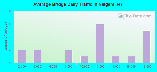
- 210,953Total average daily traffic
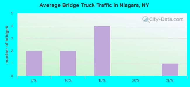
- 10,925Total average daily truck traffic
- National Bridge Inventory (NBI) Registered Bridges for Niagara
- No street view available for this location
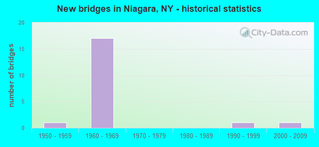
- New bridges - historical statistics
- 11950-1959
- 171960-1969
- 11990-1999
- 12000-2009
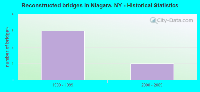
- Reconstructed bridges - Historical Statistics
- 31990-1999
- 12000-2009
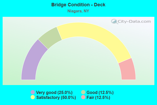
- Bridge Condition - Deck
- 25.0%Very good
- 12.5%Good
- 50.0%Satisfactory
- 12.5%Fair
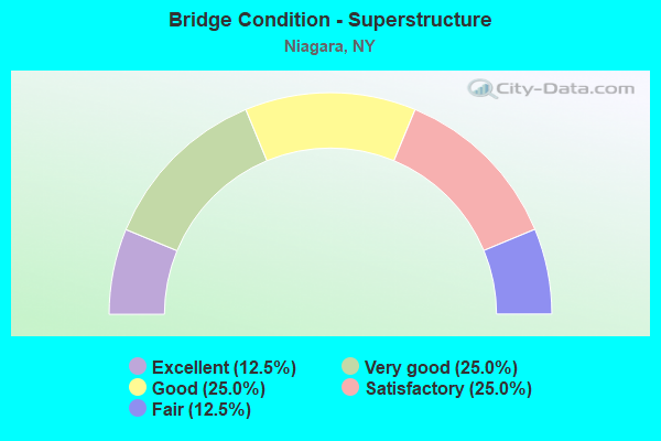
- Bridge Condition - Superstructure
- 12.5%Excellent
- 25.0%Very good
- 25.0%Good
- 25.0%Satisfactory
- 12.5%Fair
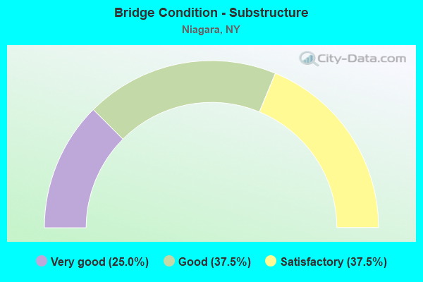
- Bridge Condition - Substructure
- 25.0%Very good
- 37.5%Good
- 37.5%Satisfactory
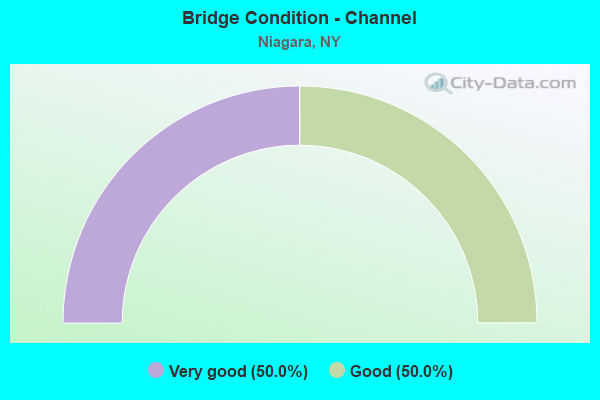
- Bridge Condition - Channel
- 50.0%Very good
- 50.0%Good
Find on map >> Show street view
Structure Number: 1021469, Location: JCT RT 31 + I-190 (Lat: 43.130156, Lng: -79.018678), Route carried "on" structure: Interstate 190, Year Built: 1961, Status: Open, Structure Length: 2.92m (9.58ft), Average Daily Traffic: 14,193 (year 2020), Truck Traffic: 24%, Average Future Daily Traffic: 15,906 (year 2040), Features Intersected: RTE 31, 31 31 54012011
Minimum Vertical Clearance: 30+ m (98+ ft), Kilometerpoint: 8.399, Lanes on structure: 4, Lanes under structure: 4, Base Highway Network: Yes, Owner: State Highway Agency, Approaching Roadway Width: 24.4m (80.1ft), Skew: 21 degrees, Material/Design: Concrete continuous, Design/Construction: Frame, Number Of Spans In Main Unit: 2, Length of Maximum Span: 13.4m (44.0ft), Curb or Sidewalk Widths: Left: 0.9m (3.0ft), Right: 0.9m (3.0ft), Curb-To-Curb Width: 24.4m (80.1ft), Out-to-Out Width: 32.3m (106.0ft)
Condition: Deck: Very good, Superstructure: Very good, Substructure: Very good, Operating Rating: 82.1 metric tons, Method Used To Determine Operating Rating: Field evaluation and documented engineering judgment, Inventory Rating: 32.7 metric tons, Method Used To Determine Inventory Rating: Field evaluation and documented engineering judgment, Structural Evaluation: Equal to present desirable criteria, Deck Geometry: Superior to present desirable criteria, Underclear: Meets minimum limits, Approach Roadway Alignment: Better than present minimum criteria, Length Of Structure Improvement: 2.92m (9.58ft), Designated Inspection Frequency: Every 24 months, Inspection Date: March 2020, Bridge Improvement Cost: $6,354,000, Roadway Improvement Cost: $3,721,000, Total Project Cost: $10,075,000 ( Estimate for 2021), Wearing Surface/Protective System: Wearing Surface: Monolithic Concrete
Find on map >> Show street view
Structure Number: 102147, Location: 0.1 MI W JCT RTS 31 & 265 (Lat: 43.129975, Lng: -79.009753), Route carried "on" structure: State highway 31, Year Built: 2003, Status: Open, Structure Length: 0.85m (2.79ft), Average Daily Traffic: 7,305 (year 2018), Truck Traffic: 5%, Average Future Daily Traffic: 7,339 (year 2040), Design Load: HS 25 or greater, Features Intersected: GILL CREEK
Minimum Vertical Clearance: 30+ m (98+ ft), Kilometerpoint: 4.151, Lanes on structure: 2, Base Highway Network: Yes, Owner: State Highway Agency, Approaching Roadway Width: 11.9m (39.0ft), Skew: 1 degrees, Material/Design: Concrete, Design/Construction: Culvert, Number Of Spans In Main Unit: 1, Length of Maximum Span: 7.9m (25.9ft), Curb-To-Curb Width: 12.0m (39.4ft), Out-to-Out Width: 13.0m (42.7ft)
Condition: Channel: Very good, Culverts: Good, Operating Rating: 67.1 metric tons, Method Used To Determine Operating Rating: Load Factor (LF), Inventory Rating: 40.8 metric tons, Method Used To Determine Inventory Rating: Load Factor (LF), Structural Evaluation: Better than present minimum criteria, Deck Geometry: Somewhat better than minimum adequacy, Waterway Adequacy: Equal to present minimum criteria, Approach Roadway Alignment: Equal to present desirable criteria, Length Of Structure Improvement: 0.85m (2.79ft), Designated Inspection Frequency: Every 24 months, Inspection Date: July 2021, Bridge Improvement Cost: $307,000, Roadway Improvement Cost: $180,000, Total Project Cost: $486,000 ( Estimate for 2021), Wearing Surface/Protective System: Wearing Surface: Bituminous, Membrane: Other
Find on map >> Show street view
Structure Number: 1039571, Location: JCT RTS 190I & 182 (Lat: 43.107961, Lng: -78.992219), Route carried "on" structure: Interstate 190, Year Built: 1964, Status: Open, Structure Length: 6.46m (21.19ft), Average Daily Traffic: 17,624 (year 2014), Truck Traffic: 11%, Features Intersected: RTE 182
Minimum Vertical Clearance: 30+ m (98+ ft), Kilometerpoint: 4.956, Lanes on structure: 2, Lanes under structure: 4, Base Highway Network: Yes, Owner: State Highway Agency, Approaching Roadway Width: 12.2m (40.0ft), Skew: 4 degrees, Material/Design: Steel, Design/Construction: Stringer/Multi-beam, Number Of Spans In Main Unit: 3, Length of Maximum Span: 31.0m (101.7ft), Curb or Sidewalk Widths: Left: 0.5m (1.6ft), Right: 0.5m (1.6ft), Curb-To-Curb Width: 8.6m (28.2ft), Out-to-Out Width: 10.1m (33.1ft)
Condition: Deck: Satisfactory, Superstructure: Satisfactory, Substructure: Satisfactory, Operating Rating: 67.1 metric tons, Method Used To Determine Operating Rating: Load and Resistance Factor Rating (LRFR) rating reported by rating factor(RF) method using HL-93 loadings, Inventory Rating: 51.5 metric tons, Method Used To Determine Inventory Rating: Load and Resistance Factor Rating (LRFR) rating reported by rating factor(RF) method using HL-93 loadings, Structural Evaluation: Equal to present minimum criteria, Deck Geometry: High priority of corrective action, Underclear: High priority of corrective action, Approach Roadway Alignment: Somewhat better than minimum adequacy, Length Of Structure Improvement: 6.46m (21.19ft), Designated Inspection Frequency: Every 24 months, Inspection Date: August 2020, Bridge Improvement Cost: $2,588,000, Roadway Improvement Cost: $1,515,000, Total Project Cost: $4,103,000 ( Estimate for 2021), Deck Structure Type: Concrete Cast-file-Place, Wearing Surface/Protective System: Wearing Surface: Monolithic Concrete
Find on map >> Show street view
Structure Number: 1039572, Location: JCT RTS 190I & 182 (Lat: 43.108019, Lng: -78.991756), Route carried "on" structure: Interstate 190, Year Built: 1964, Status: Open, Structure Length: 6.43m (21.10ft), Average Daily Traffic: 11,674 (year 2019), Truck Traffic: 12%, Average Future Daily Traffic: 13,082 (year 2040), Features Intersected: RTE 182
Minimum Vertical Clearance: 30+ m (98+ ft), Kilometerpoint: 4.956, Lanes on structure: 2, Lanes under structure: 4, Base Highway Network: Yes, Owner: State Highway Agency, Approaching Roadway Width: 12.2m (40.0ft), Skew: 5 degrees, Material/Design: Steel, Design/Construction: Stringer/Multi-beam, Number Of Spans In Main Unit: 3, Length of Maximum Span: 32.6m (107.0ft), Curb or Sidewalk Widths: Left: 0.5m (1.6ft), Right: 0.5m (1.6ft), Curb-To-Curb Width: 8.6m (28.2ft), Out-to-Out Width: 10.1m (33.1ft)
Condition: Deck: Fair, Superstructure: Fair, Substructure: Satisfactory, Operating Rating: 80.7 metric tons, Method Used To Determine Operating Rating: Load and Resistance Factor Rating (LRFR) rating reported by rating factor(RF) method using HL-93 loadings, Inventory Rating: 62.2 metric tons, Method Used To Determine Inventory Rating: Load and Resistance Factor Rating (LRFR) rating reported by rating factor(RF) method using HL-93 loadings, Structural Evaluation: Somewhat better than minimum adequacy, Deck Geometry: High priority of corrective action, Underclear: High priority of corrective action, Approach Roadway Alignment: Somewhat better than minimum adequacy, Length Of Structure Improvement: 6.43m (21.10ft), Designated Inspection Frequency: Every 24 months, Inspection Date: August 2020, Bridge Improvement Cost: $2,567,000, Roadway Improvement Cost: $1,503,000, Total Project Cost: $4,070,000 ( Estimate for 2021), Deck Structure Type: Concrete Cast-file-Place, Wearing Surface/Protective System: Wearing Surface: Monolithic Concrete
Find on map >> Show street view
Structure Number: 103958, Location: 0.8 MI W JCT RTS 182 & 62 (Lat: 43.100858, Lng: -78.957486), Route carried "on" structure: State highway 182, Year Built: 1995, Status: Open, Structure Length: 1.98m (6.50ft), Average Daily Traffic: 6,539 (year 2018), Truck Traffic: 3%, Average Future Daily Traffic: 6,569 (year 2040), Design Load: HS 25 or greater, Features Intersected: CAYUGA CREEK
Minimum Vertical Clearance: 30+ m (98+ ft), Kilometerpoint: 8.769, Lanes on structure: 2, Base Highway Network: Yes, Owner: State Highway Agency, Approaching Roadway Width: 12.2m (40.0ft), Skew: 1 degrees, Material/Design: Prestressed concrete, Design/Construction: Box Beam or Girders - Multiple, Number Of Spans In Main Unit: 1, Length of Maximum Span: 18.8m (61.7ft), Curb-To-Curb Width: 12.2m (40.0ft), Out-to-Out Width: 12.8m (42.0ft)
Condition: Deck: Good, Superstructure: Very good, Substructure: Very good, Channel: Good, Operating Rating: 84.4 metric tons, Method Used To Determine Operating Rating: Load Factor (LF), Inventory Rating: 50.8 metric tons, Method Used To Determine Inventory Rating: Load Factor (LF), Structural Evaluation: Equal to present desirable criteria, Deck Geometry: Somewhat better than minimum adequacy, Waterway Adequacy: Equal to present minimum criteria, Approach Roadway Alignment: Equal to present desirable criteria, Length Of Structure Improvement: 1.98m (6.50ft), Designated Inspection Frequency: Every 24 months, Inspection Date: May 2021, Bridge Improvement Cost: $694,000, Roadway Improvement Cost: $406,000, Total Project Cost: $1,100,000 ( Estimate for 2021), Wearing Surface/Protective System: Wearing Surface: Monolithic Concrete
Find on map >> Show street view
Structure Number: 1039681, Location: 0.2 MI S JCT RT 190I& 182 (Lat: 43.106911, Lng: -78.989414), Route carried "on" structure: Interstate 190, Year Built: 1964, Year Reconstructed: 2003, Status: Open, Structure Length: 4.79m (15.72ft), Average Daily Traffic: 17,624 (year 2014), Truck Traffic: 11%, Design Load: HS 20, Features Intersected: PACKARD RD CR82
Minimum Vertical Clearance: 30+ m (98+ ft), Kilometerpoint: 4.730, Lanes on structure: 2, Lanes under structure: 4, Base Highway Network: Yes, Owner: State Highway Agency, Approaching Roadway Width: 12.2m (40.0ft), Skew: 2 degrees, Material/Design: Steel, Design/Construction: Stringer/Multi-beam, Number Of Spans In Main Unit: 3, Length of Maximum Span: 23.1m (75.8ft), Curb or Sidewalk Widths: Left: 0.5m (1.6ft), Right: 0.5m (1.6ft), Curb-To-Curb Width: 8.5m (27.9ft), Out-to-Out Width: 10.1m (33.1ft)
Condition: Deck: Satisfactory, Superstructure: Satisfactory, Substructure: Good, Operating Rating: 52.2 metric tons, Method Used To Determine Operating Rating: Load and Resistance Factor Rating (LRFR) rating reported by rating factor(RF) method using HL-93 loadings, Inventory Rating: 40.2 metric tons, Method Used To Determine Inventory Rating: Load and Resistance Factor Rating (LRFR) rating reported by rating factor(RF) method using HL-93 loadings, Structural Evaluation: Equal to present minimum criteria, Deck Geometry: High priority of replacement, Underclear: High priority of corrective action, Approach Roadway Alignment: Equal to present desirable criteria, Length Of Structure Improvement: 4.78m (15.68ft), Designated Inspection Frequency: Every 24 months, Inspection Date: December 2021, Bridge Improvement Cost: $1,783,000, Roadway Improvement Cost: $1,044,000, Total Project Cost: $2,826,000 ( Estimate for 2021), Deck Structure Type: Concrete Cast-file-Place, Wearing Surface/Protective System: Wearing Surface: Monolithic Concrete
Find on map >> Show street view
Structure Number: 1039682, Location: 0.2 MI S JCT RT 190I& 182 (Lat: 43.107061, Lng: -78.989128), Route carried "on" structure: Interstate 190, Year Built: 1964, Year Reconstructed: 2003, Status: Open, Structure Length: 4.75m (15.58ft), Average Daily Traffic: 11,674 (year 2019), Truck Traffic: 12%, Average Future Daily Traffic: 13,082 (year 2040), Design Load: HS 20, Features Intersected: PACKARD RD CR82
Minimum Vertical Clearance: 30+ m (98+ ft), Kilometerpoint: 4.730, Lanes on structure: 2, Lanes under structure: 4, Base Highway Network: Yes, Owner: State Highway Agency, Approaching Roadway Width: 12.2m (40.0ft), Skew: 3 degrees, Material/Design: Steel, Design/Construction: Stringer/Multi-beam, Number Of Spans In Main Unit: 3, Length of Maximum Span: 23.4m (76.8ft), Curb or Sidewalk Widths: Left: 0.5m (1.6ft), Right: 0.5m (1.6ft), Curb-To-Curb Width: 8.5m (27.9ft), Out-to-Out Width: 10.1m (33.1ft)
Condition: Deck: Satisfactory, Superstructure: Good, Substructure: Good, Operating Rating: 48.9 metric tons, Method Used To Determine Operating Rating: Load and Resistance Factor Rating (LRFR) rating reported by rating factor(RF) method using HL-93 loadings, Inventory Rating: 37.9 metric tons, Method Used To Determine Inventory Rating: Load and Resistance Factor Rating (LRFR) rating reported by rating factor(RF) method using HL-93 loadings, Structural Evaluation: Better than present minimum criteria, Deck Geometry: High priority of replacement, Underclear: High priority of corrective action, Approach Roadway Alignment: Equal to present minimum criteria, Length Of Structure Improvement: 4.75m (15.58ft), Designated Inspection Frequency: Every 24 months, Inspection Date: August 2020, Bridge Improvement Cost: $1,777,000, Roadway Improvement Cost: $1,041,000, Total Project Cost: $2,818,000 ( Estimate for 2021), Deck Structure Type: Concrete Cast-file-Place, Wearing Surface/Protective System: Wearing Surface: Monolithic Concrete
Find on map >> Show street view
Structure Number: 221355, Location: 1.8 MI NE OFNIAGARA FALLS (Lat: 43.126047, Lng: -78.950922), Route carried "on" structure: Other road , Year Built: 1963, Year Reconstructed: 2007, Status: Open, Structure Length: 5.97m (19.59ft), Average Daily Traffic: 2,488 (year 2017), Truck Traffic: 3%, Average Future Daily Traffic: 3,483 (year 2037), Design Load: HS 25 or greater, Features Intersected: CSXT/AMTRAK, Facility Carried by Structure: TUSCARORA ROAD
Minimum Vertical Clearance: 30+ m (98+ ft), Kilometerpoint: 0.499, Lanes on structure: 2, Owner: Town or Township Highway Agency, Approaching Roadway Width: 10.4m (34.1ft), Skew: 1 degrees, Material/Design: Steel continuous, Design/Construction: Stringer/Multi-beam, Number Of Spans In Main Unit: 3, Length of Maximum Span: 23.7m (77.8ft), Curb-To-Curb Width: 10.8m (35.4ft), Out-to-Out Width: 11.7m (38.4ft)
Condition: Deck: Very good, Superstructure: Excellent, Substructure: Good, Operating Rating: 38.2 metric tons, Method Used To Determine Operating Rating: Load and Resistance Factor Rating (LRFR) rating reported by rating factor(RF) method using HL-93 loadings, Inventory Rating: 29.5 metric tons, Method Used To Determine Inventory Rating: Load and Resistance Factor Rating (LRFR) rating reported by rating factor(RF) method using HL-93 loadings, Structural Evaluation: Better than present minimum criteria, Deck Geometry: Somewhat better than minimum adequacy, Underclear: Better than present minimum criteria, Approach Roadway Alignment: Meets minimum limits, Length Of Structure Improvement: 5.97m (19.59ft), Designated Inspection Frequency: Every 24 months, Inspection Date: September 2021, Bridge Improvement Cost: $2,485,000, Roadway Improvement Cost: $1,455,000, Total Project Cost: $3,940,000 ( Estimate for 2021), Deck Structure Type: Concrete Cast-file-Place, Wearing Surface/Protective System: Wearing Surface: Integral Concrete, Deck Protection: Epoxy Coated Reinforcing
Find on map >> Show street view
Structure Number: 332927, Location: 2.5 MI NE OF NIAGARA FLLS (Lat: 43.122453, Lng: -78.972958), Route carried "on" structure: County highway , Year Built: 1959, Year Reconstructed: 1995, Status: Open, Structure Length: 10.06m (33.01ft), Average Daily Traffic: 3,478 (year 2020), Truck Traffic: 6%, Average Future Daily Traffic: 3,672 (year 2040), Design Load: HS 25 or greater, Features Intersected: CSX TRANS/ AMTRAK, Facility Carried by Structure: LOCKPORT ROAD
Minimum Vertical Clearance: 30+ m (98+ ft), Kilometerpoint: 2.204, Lanes on structure: 2, Owner: County Highway Agency, Approaching Roadway Width: 17.7m (58.1ft), Skew: 4 degrees, Material/Design: Steel continuous, Design/Construction: Stringer/Multi-beam, Number Of Spans In Main Unit: 4, Length of Maximum Span: 26.8m (87.9ft), Curb-To-Curb Width: 16.5m (54.1ft), Out-to-Out Width: 17.4m (57.1ft)
Condition: Deck: Satisfactory, Superstructure: Good, Substructure: Satisfactory, Operating Rating: 73.5 metric tons, Method Used To Determine Operating Rating: Load Factor (LF), Inventory Rating: 40.8 metric tons, Method Used To Determine Inventory Rating: Load Factor (LF), Structural Evaluation: Equal to present minimum criteria, Deck Geometry: Superior to present desirable criteria, Underclear: Somewhat better than minimum adequacy, Approach Roadway Alignment: Equal to present desirable criteria, Length Of Structure Improvement: 10.05m (32.97ft), Designated Inspection Frequency: Every 24 months, Inspection Date: November 2020, Bridge Improvement Cost: $6,296,000, Roadway Improvement Cost: $3,687,000, Total Project Cost: $9,983,000 ( Estimate for 2021), Deck Structure Type: Concrete Cast-file-Place, Wearing Surface/Protective System: Wearing Surface: Integral Concrete, Deck Protection: Epoxy Coated Reinforcing
Find on map >> Show street view
Structure Number: 1021469, Location: JCT RT 31 + I-190 (Lat: 43.130156, Lng: -79.018678), Route carried "under" structure: State highway 31, Year Built: 1961, Structure Length: 0. m, Average Daily Traffic: 12,159 (year 2000), Features Intersected: RTE 31, 31 31 54012011, Facility Carried by Structure: RTE I190
Minimum Vertical Clearance: 5.33m (17.49ft), Kilometerpoint: 1.818, Lanes on structure: 4, Lanes under structure: 2, Material/Design: Concrete continuous, Design/Construction: Frame, Length of Maximum Span: 13.4m (44.0ft)
Find on map >> Show street view
Structure Number: 1021469, Location: JCT RT 31 + I-190 (Lat: 43.130156, Lng: -79.018678), Route carried "under" structure: State highway , Year Built: 1961, Structure Length: 0. m, Average Daily Traffic: 9,355 (year 1992), Features Intersected: RTE 31, 31 31 54012011, Facility Carried by Structure: RTE I190
Minimum Vertical Clearance: 5.54m (18.18ft), Kilometerpoint: 1.818, Lanes on structure: 4, Lanes under structure: 2, Material/Design: Concrete continuous, Design/Construction: Frame, Length of Maximum Span: 13.4m (44.0ft)
Find on map >> Show street view
Structure Number: 1039571, Location: JCT RTS 190I & 182 (Lat: 43.107961, Lng: -78.992219), Route carried "under" structure: State highway 182, Year Built: 1964, Structure Length: 0. m, Average Daily Traffic: 11,670 (year 2002), Features Intersected: RTE 182, Facility Carried by Structure: RTE I190
Minimum Vertical Clearance: 4.87m (15.98ft), Kilometerpoint: 0.547, Lanes on structure: 2, Lanes under structure: 4, Material/Design: Steel, Design/Construction: Stringer/Multi-beam, Length of Maximum Span: 31.0m (101.7ft)
Find on map >> Show street view
Structure Number: 1039572, Location: JCT RTS 190I & 182 (Lat: 43.108019, Lng: -78.991756), Route carried "under" structure: State highway 182, Year Built: 1964, Structure Length: 0. m, Average Daily Traffic: 11,670 (year 2002), Features Intersected: RTE 182, Facility Carried by Structure: RTE I190
Minimum Vertical Clearance: 4.52m (14.83ft), Kilometerpoint: 0.547, Lanes on structure: 2, Lanes under structure: 4, Material/Design: Steel, Design/Construction: Stringer/Multi-beam, Length of Maximum Span: 32.6m (107.0ft)
Find on map >> Show street view
Structure Number: 1039681, Location: 0.2 MI S JCT RT 190I& 182 (Lat: 43.106911, Lng: -78.989414), Route carried "under" structure: County highway , Year Built: 1964, Structure Length: 0. m, Average Daily Traffic: 11,930 (year 1977), Features Intersected: PACKARD RD CR82, Facility Carried by Structure: RTE I190
Minimum Vertical Clearance: 5.08m (16.67ft), Kilometerpoint: 0.000, Lanes on structure: 2, Lanes under structure: 4, Material/Design: Steel, Design/Construction: Stringer/Multi-beam, Length of Maximum Span: 23.1m (75.8ft)
Find on map >> Show street view
Structure Number: 1039682, Location: 0.2 MI S JCT RT 190I& 182 (Lat: 43.107061, Lng: -78.989128), Route carried "under" structure: County highway , Year Built: 1964, Structure Length: 0. m, Average Daily Traffic: 11,930 (year 1977), Features Intersected: PACKARD RD CR82, Facility Carried by Structure: RTE I190
Minimum Vertical Clearance: 4.60m (15.09ft), Kilometerpoint: 0.000, Lanes on structure: 2, Lanes under structure: 4, Material/Design: Steel, Design/Construction: Stringer/Multi-beam, Length of Maximum Span: 23.4m (76.8ft)
Find on map >> Show street view
Structure Number: 7043881, Location: 2.5 MI N JCT RTS 265 + 62 (Lat: 43.118797, Lng: -78.996044), Route carried "under" structure: State highway 265, Year Built: 1963, Structure Length: 0. m, Average Daily Traffic: 16,480 (year 2002), Features Intersected: RTE 265, MILITARY RD, Facility Carried by Structure: CSX TRANS/AMTRAK
Minimum Vertical Clearance: 4.42m (14.50ft), Kilometerpoint: 3.105, Lanes under structure: 4, Material/Design: Steel, Design/Construction: Girder and Floorbeam System, Length of Maximum Span: 20.1m (65.9ft)
Find on map >> Show street view
Structure Number: 7043881, Location: 2.5 MI N JCT RTS 265 + 62 (Lat: 43.118797, Lng: -78.996044), Route carried "under" structure: State highway , Year Built: 1963, Structure Length: 0. m, Average Daily Traffic: 100 (year 2021), Features Intersected: RTE 265, MILITARY RD, Facility Carried by Structure: CSX TRANS/AMTRAK
Minimum Vertical Clearance: 4.39m (14.40ft), Kilometerpoint: 0.000, Lanes under structure: 4, Material/Design: Steel, Design/Construction: Girder and Floorbeam System, Length of Maximum Span: 20.1m (65.9ft)
Find on map >> Show street view
Structure Number: 7043882, Location: 2.5 MI N JCT RTS 265 + 62 (Lat: 43.118706, Lng: -78.995956), Route carried "under" structure: State highway 265, Year Built: 1963, Structure Length: 0. m, Average Daily Traffic: 16,480 (year 2002), Features Intersected: RTE 265, Facility Carried by Structure: CSX TRANS/AMTRAK
Minimum Vertical Clearance: 4.39m (14.40ft), Kilometerpoint: 3.105, Lanes under structure: 4, Material/Design: Steel, Design/Construction: Girder and Floorbeam System, Length of Maximum Span: 20.1m (65.9ft)
Find on map >> Show street view
Structure Number: 7043883, Location: 2.5 MI N JCT RTS 265 & 62 (Lat: 43.118628, Lng: -78.995881), Route carried "under" structure: State highway 265, Year Built: 1963, Structure Length: 0. m, Average Daily Traffic: 16,480 (year 2002), Features Intersected: RTE 265, MILITARY RD, Facility Carried by Structure: CSX TRANS/AMTRAK
Minimum Vertical Clearance: 4.54m (14.90ft), Kilometerpoint: 3.105, Lanes under structure: 4, Material/Design: Steel, Design/Construction: Girder and Floorbeam System, Length of Maximum Span: 20.1m (65.9ft)
Find on map >> Show street view
Structure Number: 7043883, Location: 2.5 MI N JCT RTS 265 & 62 (Lat: 43.118628, Lng: -78.995881), Route carried "under" structure: State highway , Year Built: 1963, Structure Length: 0. m, Average Daily Traffic: 100 (year 2021), Features Intersected: RTE 265, MILITARY RD, Facility Carried by Structure: CSX TRANS/AMTRAK
Minimum Vertical Clearance: 4.54m (14.90ft), Kilometerpoint: 0.000, Lanes under structure: 4, Material/Design: Steel, Design/Construction: Girder and Floorbeam System, Length of Maximum Span: 20.1m (65.9ft)