Bridge Statistics for Nichols, New York (NY)
Condition, Traffic, Stress, Structural Evaluation, Project Costs
- National Bridge Inventory (NBI) Statistics
- 29Number of bridges
- 322ft / 97.8mTotal length
- $49,892,000Total costs
- 128,526Total average daily traffic
- 28,247Total average daily truck traffic
- National Bridge Inventory (NBI) Registered Bridges for Nichols
- No street view available for this location
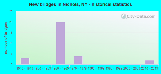
- New bridges - historical statistics
- 31940-1949
- 201960-1969
- 41970-1979
- 22010-2019


- Bridge Condition - Deck
- 5.6%Very good
- 44.4%Good
- 38.9%Satisfactory
- 5.6%Fair
- 5.6%Poor

- Bridge Condition - Superstructure
- 11.1%Very good
- 27.8%Good
- 50.0%Satisfactory
- 11.1%Fair

- Bridge Condition - Substructure
- 5.6%Excellent
- 5.6%Very good
- 27.8%Good
- 61.1%Satisfactory

- Bridge Condition - Channel
- 7.7%Very good
- 15.4%Good
- 38.5%Satisfactory
- 30.8%Fair
- 7.7%Poor

- Bridge Condition - Culverts
- 33.3%Good
- 66.7%Satisfactory
Find on map >> Show street view
Structure Number: 105463, Location: JCT RTE 282 + SUSQUEHANNA (Lat: 42.028908, Lng: -76.384400), Route carried "on" structure: State highway 282, Year Built: 1966, Status: Open, Structure Length: 21.98m (72.11ft), Average Daily Traffic: 3,520 (year 2020), Truck Traffic: 12%, Average Future Daily Traffic: 3,672 (year 2040), Design Load: HS 20+Mod, Features Intersected: NORFOLK SOUTHERN RR, SU
Minimum Vertical Clearance: 30+ m (98+ ft), Kilometerpoint: 4.907, Lanes on structure: 2, Base Highway Network: Yes, Owner: State Highway Agency, Approaching Roadway Width: 11.3m (37.1ft), Material/Design: Steel continuous, Design/Construction: Stringer/Multi-beam, Number Of Spans In Main Unit: 5, Length of Maximum Span: 50.5m (165.7ft), Curb-To-Curb Width: 9.1m (29.9ft), Out-to-Out Width: 10.7m (35.1ft)
Condition: Deck: Satisfactory, Superstructure: Good, Substructure: Good, Channel: Satisfactory, Operating Rating: 47.2 metric tons, Method Used To Determine Operating Rating: Load Factor (LF), Inventory Rating: 28.1 metric tons, Method Used To Determine Inventory Rating: Load Factor (LF), Structural Evaluation: Better than present minimum criteria, Deck Geometry: Meets minimum limits, Underclear: Equal to present minimum criteria, Waterway Adequacy: Somewhat better than minimum adequacy, Approach Roadway Alignment: Equal to present desirable criteria, Length Of Structure Improvement: 21.97m (72.08ft), Designated Inspection Frequency: Every 24 months, Underwater Inspection Frequency: Every 60 months, Inspection Date: September 2020, Underwater Inspection Date: October 2017, Bridge Improvement Cost: $4,804,000, Roadway Improvement Cost: $2,813,000, Total Project Cost: $7,618,000 ( Estimate for 2021), Deck Structure Type: Concrete Cast-file-Place, Wearing Surface/Protective System: Wearing Surface: Integral Concrete
Find on map >> Show street view
Structure Number: 1054641, Location: JCT RTS 17 + 282 (Lat: 42.026767, Lng: -76.385242), Route carried "on" structure: State highway 17, Year Built: 1968, Status: Open, Structure Length: 3.51m (11.52ft), Average Daily Traffic: 7,235 (year 2020), Truck Traffic: 28%, Average Future Daily Traffic: 11,290 (year 2040), Design Load: HS 20+Mod, Features Intersected: RTE 282
Minimum Vertical Clearance: 30+ m (98+ ft), Kilometerpoint: 15.800, Lanes on structure: 2, Lanes under structure: 2, Base Highway Network: Yes, Owner: State Highway Agency, Approaching Roadway Width: 12.2m (40.0ft), Skew: 2 degrees, Material/Design: Steel, Design/Construction: Stringer/Multi-beam, Number Of Spans In Main Unit: 1, Length of Maximum Span: 33.5m (109.9ft), Curb-To-Curb Width: 12.2m (40.0ft), Out-to-Out Width: 13.2m (43.3ft)
Condition: Deck: Satisfactory, Superstructure: Satisfactory, Substructure: Satisfactory, Operating Rating: 73.5 metric tons, Method Used To Determine Operating Rating: Load Factor (LF), Inventory Rating: 43.5 metric tons, Method Used To Determine Inventory Rating: Load Factor (LF), Structural Evaluation: Equal to present minimum criteria, Deck Geometry: Better than present minimum criteria, Underclear: Somewhat better than minimum adequacy, Approach Roadway Alignment: Equal to present desirable criteria, Length Of Structure Improvement: 3.50m (11.48ft), Designated Inspection Frequency: Every 24 months, Inspection Date: April 2020, Bridge Improvement Cost: $1,274,000, Roadway Improvement Cost: $746,000, Total Project Cost: $2,020,000 ( Estimate for 2021), Deck Structure Type: Concrete Cast-file-Place, Wearing Surface/Protective System: Wearing Surface: Bituminous
Find on map >> Show street view
Structure Number: 1054642, Location: JCT RTS 17 + 282 (Lat: 42.026489, Lng: -76.385347), Route carried "on" structure: State highway 17, Year Built: 1968, Status: Open, Structure Length: 3.51m (11.52ft), Average Daily Traffic: 7,235 (year 2020), Truck Traffic: 28%, Average Future Daily Traffic: 11,290 (year 2040), Design Load: HS 20+Mod, Features Intersected: RTE 282
Minimum Vertical Clearance: 30+ m (98+ ft), Kilometerpoint: 15.800, Lanes on structure: 2, Lanes under structure: 2, Base Highway Network: Yes, Owner: State Highway Agency, Approaching Roadway Width: 11.9m (39.0ft), Skew: 2 degrees, Material/Design: Steel, Design/Construction: Stringer/Multi-beam, Number Of Spans In Main Unit: 1, Length of Maximum Span: 33.5m (109.9ft), Curb-To-Curb Width: 12.2m (40.0ft), Out-to-Out Width: 13.3m (43.6ft)
Condition: Deck: Good, Superstructure: Good, Substructure: Good, Operating Rating: 77.1 metric tons, Method Used To Determine Operating Rating: Load Factor (LF), Inventory Rating: 46.3 metric tons, Method Used To Determine Inventory Rating: Load Factor (LF), Structural Evaluation: Better than present minimum criteria, Deck Geometry: Better than present minimum criteria, Underclear: Equal to present minimum criteria, Approach Roadway Alignment: Equal to present desirable criteria, Length Of Structure Improvement: 3.50m (11.48ft), Designated Inspection Frequency: Every 24 months, Inspection Date: April 2020, Bridge Improvement Cost: $1,294,000, Roadway Improvement Cost: $757,000, Total Project Cost: $2,051,000 ( Estimate for 2021), Deck Structure Type: Concrete Cast-file-Place, Wearing Surface/Protective System: Wearing Surface: Monolithic Concrete
Find on map >> Show street view
Structure Number: 1054651, Location: 0.1 MI E RTS 17 + 282 (Lat: 42.026678, Lng: -76.382975), Route carried "on" structure: State highway 17, Year Built: 1967, Status: Open, Structure Length: 3.51m (11.52ft), Average Daily Traffic: 6,997 (year 2009), Truck Traffic: 25%, Average Future Daily Traffic: 10,918 (year 2040), Design Load: HS 20+Mod, Features Intersected: SACKETTS CREEK
Minimum Vertical Clearance: 30+ m (98+ ft), Kilometerpoint: 15.993, Lanes on structure: 3, Base Highway Network: Yes, Owner: State Highway Agency, Approaching Roadway Width: 11.9m (39.0ft), Skew: 1 degrees, Material/Design: Steel, Design/Construction: Stringer/Multi-beam, Number Of Spans In Main Unit: 1, Length of Maximum Span: 33.5m (109.9ft), Curb-To-Curb Width: 12.8m (42.0ft), Out-to-Out Width: 14.4m (47.2ft)
Condition: Deck: Satisfactory, Superstructure: Satisfactory, Substructure: Satisfactory, Channel: Fair, Operating Rating: 54.4 metric tons, Method Used To Determine Operating Rating: Load Factor (LF), Inventory Rating: 32.7 metric tons, Method Used To Determine Inventory Rating: Load Factor (LF), Structural Evaluation: Equal to present minimum criteria, Deck Geometry: Meets minimum limits, Waterway Adequacy: Equal to present minimum criteria, Approach Roadway Alignment: Equal to present desirable criteria, Length Of Structure Improvement: 3.50m (11.48ft), Designated Inspection Frequency: Every 24 months, Inspection Date: September 2020, Bridge Improvement Cost: $1,389,000, Roadway Improvement Cost: $813,000, Total Project Cost: $2,203,000 ( Estimate for 2021), Deck Structure Type: Concrete Cast-file-Place, Wearing Surface/Protective System: Wearing Surface: Monolithic Concrete
Find on map >> Show street view
Structure Number: 1054652, Location: 0.1 MI E RTS 17 + 282 (Lat: 42.026433, Lng: -76.383139), Route carried "on" structure: State highway 17, Year Built: 1967, Status: Open, Structure Length: 3.51m (11.52ft), Average Daily Traffic: 6,997 (year 2009), Truck Traffic: 25%, Average Future Daily Traffic: 10,918 (year 2040), Design Load: HS 20+Mod, Features Intersected: SACKETTS CREEK
Minimum Vertical Clearance: 30+ m (98+ ft), Kilometerpoint: 15.993, Lanes on structure: 3, Base Highway Network: Yes, Owner: State Highway Agency, Approaching Roadway Width: 14.6m (47.9ft), Skew: 1 degrees, Material/Design: Steel, Design/Construction: Stringer/Multi-beam, Number Of Spans In Main Unit: 1, Length of Maximum Span: 33.5m (109.9ft), Curb-To-Curb Width: 14.6m (47.9ft), Out-to-Out Width: 15.6m (51.2ft)
Condition: Deck: Satisfactory, Superstructure: Satisfactory, Substructure: Satisfactory, Channel: Satisfactory, Operating Rating: 63.5 metric tons, Method Used To Determine Operating Rating: Load Factor (LF), Inventory Rating: 38.1 metric tons, Method Used To Determine Inventory Rating: Load Factor (LF), Structural Evaluation: Equal to present minimum criteria, Deck Geometry: Somewhat better than minimum adequacy, Waterway Adequacy: Equal to present minimum criteria, Approach Roadway Alignment: Equal to present desirable criteria, Length Of Structure Improvement: 3.50m (11.48ft), Designated Inspection Frequency: Every 24 months, Inspection Date: September 2020, Bridge Improvement Cost: $1,484,000, Roadway Improvement Cost: $869,000, Total Project Cost: $2,353,000 ( Estimate for 2021), Deck Structure Type: Concrete Cast-file-Place, Wearing Surface/Protective System: Wearing Surface: Monolithic Concrete
Find on map >> Show street view
Structure Number: 1054661, Location: 1.3 MI E RTS 17 + 282 (Lat: 42.024092, Lng: -76.361700), Route carried "on" structure: State highway 17, Year Built: 1968, Status: Open, Structure Length: 4.69m (15.39ft), Average Daily Traffic: 6,997 (year 2009), Truck Traffic: 25%, Average Future Daily Traffic: 10,918 (year 2040), Design Load: HS 20+Mod, Features Intersected: WAPPASENING CREEK
Minimum Vertical Clearance: 30+ m (98+ ft), Kilometerpoint: 17.796, Lanes on structure: 2, Base Highway Network: Yes, Owner: State Highway Agency, Approaching Roadway Width: 11.6m (38.1ft), Material/Design: Steel, Design/Construction: Stringer/Multi-beam, Number Of Spans In Main Unit: 1, Length of Maximum Span: 45.7m (149.9ft), Curb-To-Curb Width: 11.9m (39.0ft), Out-to-Out Width: 13.0m (42.7ft)
Condition: Deck: Satisfactory, Superstructure: Satisfactory, Substructure: Satisfactory, Channel: Very good, Operating Rating: 79.8 metric tons, Method Used To Determine Operating Rating: Load Factor (LF), Inventory Rating: 48.1 metric tons, Method Used To Determine Inventory Rating: Load Factor (LF), Structural Evaluation: Equal to present minimum criteria, Deck Geometry: Better than present minimum criteria, Waterway Adequacy: Somewhat better than minimum adequacy, Approach Roadway Alignment: Equal to present desirable criteria, Length Of Structure Improvement: 4.69m (15.39ft), Designated Inspection Frequency: Every 24 months, Inspection Date: July 2020, Bridge Improvement Cost: $1,681,000, Roadway Improvement Cost: $984,000, Total Project Cost: $2,665,000 ( Estimate for 2021), Deck Structure Type: Concrete Cast-file-Place, Wearing Surface/Protective System: Wearing Surface: Monolithic Concrete
Find on map >> Show street view
Structure Number: 1054662, Location: 1.3 MI E RTS 17 + 282 (Lat: 42.023864, Lng: -76.361647), Route carried "on" structure: State highway 17, Year Built: 1968, Status: Open, Structure Length: 4.69m (15.39ft), Average Daily Traffic: 6,997 (year 2009), Truck Traffic: 25%, Average Future Daily Traffic: 10,918 (year 2040), Design Load: HS 20+Mod, Features Intersected: WAPPASENING CREEK
Minimum Vertical Clearance: 30+ m (98+ ft), Kilometerpoint: 17.796, Lanes on structure: 2, Base Highway Network: Yes, Owner: State Highway Agency, Approaching Roadway Width: 11.9m (39.0ft), Material/Design: Steel, Design/Construction: Stringer/Multi-beam, Number Of Spans In Main Unit: 1, Length of Maximum Span: 45.7m (149.9ft), Curb-To-Curb Width: 11.9m (39.0ft), Out-to-Out Width: 13.0m (42.7ft)
Condition: Deck: Good, Superstructure: Satisfactory, Substructure: Satisfactory, Channel: Good, Operating Rating: 79.8 metric tons, Method Used To Determine Operating Rating: Load Factor (LF), Inventory Rating: 48.1 metric tons, Method Used To Determine Inventory Rating: Load Factor (LF), Structural Evaluation: Equal to present minimum criteria, Deck Geometry: Better than present minimum criteria, Waterway Adequacy: Somewhat better than minimum adequacy, Approach Roadway Alignment: Equal to present desirable criteria, Length Of Structure Improvement: 4.69m (15.39ft), Designated Inspection Frequency: Every 24 months, Inspection Date: July 2020, Bridge Improvement Cost: $1,681,000, Roadway Improvement Cost: $984,000, Total Project Cost: $2,665,000 ( Estimate for 2021), Deck Structure Type: Concrete Cast-file-Place, Wearing Surface/Protective System: Wearing Surface: Monolithic Concrete
Find on map >> Show street view
Structure Number: 1054671, Location: 1.6 MI E RTS 17 + 282 (Lat: 42.024325, Lng: -76.356994), Route carried "on" structure: State highway 17, Year Built: 1968, Status: Open, Structure Length: 6.58m (21.59ft), Average Daily Traffic: 6,997 (year 2009), Truck Traffic: 25%, Average Future Daily Traffic: 10,918 (year 2040), Design Load: HS 20+Mod, Features Intersected: COUNTY ROAD 6
Minimum Vertical Clearance: 30+ m (98+ ft), Kilometerpoint: 18.150, Lanes on structure: 2, Lanes under structure: 2, Base Highway Network: Yes, Owner: State Highway Agency, Approaching Roadway Width: 10.7m (35.1ft), Skew: 5 degrees, Material/Design: Steel, Design/Construction: Stringer/Multi-beam, Number Of Spans In Main Unit: 3, Length of Maximum Span: 27.1m (88.9ft), Curb-To-Curb Width: 9.3m (30.5ft), Out-to-Out Width: 10.7m (35.1ft)
Condition: Deck: Good, Superstructure: Fair, Substructure: Satisfactory, Operating Rating: 75.3 metric tons, Method Used To Determine Operating Rating: Load Factor (LF), Inventory Rating: 45.4 metric tons, Method Used To Determine Inventory Rating: Load Factor (LF), Structural Evaluation: Somewhat better than minimum adequacy, Deck Geometry: Meets minimum limits, Underclear: Meets minimum limits, Approach Roadway Alignment: Equal to present desirable criteria, Length Of Structure Improvement: 6.58m (21.59ft), Designated Inspection Frequency: Every 24 months, Inspection Date: July 2020, Bridge Improvement Cost: $1,647,000, Roadway Improvement Cost: $964,000, Total Project Cost: $2,611,000 ( Estimate for 2021), Deck Structure Type: Concrete Cast-file-Place, Wearing Surface/Protective System: Wearing Surface: Monolithic Concrete
Find on map >> Show street view
Structure Number: 1054672, Location: 1.6 MI E RTS 17 + 282 (Lat: 42.024022, Lng: -76.357403), Route carried "on" structure: State highway 17, Year Built: 1968, Status: Open, Structure Length: 6.25m (20.51ft), Average Daily Traffic: 6,997 (year 2009), Truck Traffic: 25%, Average Future Daily Traffic: 10,918 (year 2040), Design Load: HS 20+Mod, Features Intersected: COUNTY ROAD 6
Minimum Vertical Clearance: 30+ m (98+ ft), Kilometerpoint: 18.150, Lanes on structure: 2, Lanes under structure: 2, Base Highway Network: Yes, Owner: State Highway Agency, Approaching Roadway Width: 12.2m (40.0ft), Skew: 5 degrees, Material/Design: Steel, Design/Construction: Stringer/Multi-beam, Number Of Spans In Main Unit: 3, Length of Maximum Span: 25.2m (82.7ft), Curb-To-Curb Width: 9.1m (29.9ft), Out-to-Out Width: 10.7m (35.1ft)
Condition: Deck: Good, Superstructure: Fair, Substructure: Good, Operating Rating: 76.2 metric tons, Method Used To Determine Operating Rating: Load Factor (LF), Inventory Rating: 45.4 metric tons, Method Used To Determine Inventory Rating: Load Factor (LF), Structural Evaluation: Somewhat better than minimum adequacy, Deck Geometry: Meets minimum limits, Underclear: Meets minimum limits, Approach Roadway Alignment: Equal to present desirable criteria, Length Of Structure Improvement: 6.24m (20.47ft), Designated Inspection Frequency: Every 24 months, Inspection Date: July 2020, Bridge Improvement Cost: $1,593,000, Roadway Improvement Cost: $933,000, Total Project Cost: $2,526,000 ( Estimate for 2021), Deck Structure Type: Concrete Cast-file-Place, Wearing Surface/Protective System: Wearing Surface: Monolithic Concrete
Find on map >> Show street view
Structure Number: 1054681, Location: 3.8 MI NE JCT SH417&SH275 (Lat: 42.060353, Lng: -76.329886), Route carried "on" structure: State highway 17, Year Built: 1968, Status: Open, Structure Length: 1.49m (4.89ft), Average Daily Traffic: 6,997 (year 2009), Truck Traffic: 25%, Average Future Daily Traffic: 10,918 (year 2040), Design Load: HS 20+Mod, Features Intersected: HUNTS CREEK
Minimum Vertical Clearance: 30+ m (98+ ft), Kilometerpoint: 22.880, Lanes on structure: 3, Base Highway Network: Yes, Owner: State Highway Agency, Approaching Roadway Width: 15.5m (50.9ft), Skew: 2 degrees, Material/Design: Concrete, Design/Construction: Culvert, Number Of Spans In Main Unit: 2, Length of Maximum Span: 7.3m (24.0ft)
Condition: Channel: Fair, Culverts: Satisfactory, Structural Evaluation: Equal to present minimum criteria, Waterway Adequacy: Equal to present desirable criteria, Approach Roadway Alignment: Equal to present desirable criteria, Length Of Structure Improvement: 1.49m (4.89ft), Designated Inspection Frequency: Every 24 months, Inspection Date: April 2020, Bridge Improvement Cost: $787,000, Roadway Improvement Cost: $461,000, Total Project Cost: $1,249,000 ( Estimate for 2021)
Find on map >> Show street view
Structure Number: 1054682, Location: 3.8 MI NE JCT SH417&SH275 (Lat: 42.059992, Lng: -76.329503), Route carried "on" structure: State highway 17, Year Built: 1968, Status: Open, Structure Length: 1.46m (4.79ft), Average Daily Traffic: 6,997 (year 2009), Truck Traffic: 25%, Average Future Daily Traffic: 10,918 (year 2040), Design Load: HS 20+Mod, Features Intersected: HUNTS CREEK
Minimum Vertical Clearance: 30+ m (98+ ft), Kilometerpoint: 22.880, Lanes on structure: 2, Base Highway Network: Yes, Owner: State Highway Agency, Approaching Roadway Width: 11.3m (37.1ft), Skew: 1 degrees, Material/Design: Concrete, Design/Construction: Culvert, Number Of Spans In Main Unit: 2, Length of Maximum Span: 6.7m (22.0ft)
Condition: Channel: Satisfactory, Culverts: Satisfactory, Structural Evaluation: Equal to present minimum criteria, Waterway Adequacy: Equal to present desirable criteria, Approach Roadway Alignment: Equal to present desirable criteria, Length Of Structure Improvement: 1.46m (4.79ft), Designated Inspection Frequency: Every 24 months, Inspection Date: April 2020, Bridge Improvement Cost: $498,000, Roadway Improvement Cost: $292,000, Total Project Cost: $790,000 ( Estimate for 2021)
Find on map >> Show street view
Structure Number: 1054691, Location: 4.8 MI NE RTS 17 + 282 (Lat: 42.063483, Lng: -76.326908), Route carried "on" structure: State highway 17, Year Built: 1968, Status: Open, Structure Length: 3.51m (11.52ft), Average Daily Traffic: 7,181 (year 2009), Truck Traffic: 25%, Average Future Daily Traffic: 8,321 (year 2040), Design Load: HS 20+Mod, Features Intersected: STANTON HILL RD
Minimum Vertical Clearance: 30+ m (98+ ft), Kilometerpoint: 23.363, Lanes on structure: 2, Lanes under structure: 2, Base Highway Network: Yes, Owner: State Highway Agency, Approaching Roadway Width: 11.6m (38.1ft), Skew: 2 degrees, Material/Design: Steel, Design/Construction: Stringer/Multi-beam, Number Of Spans In Main Unit: 1, Length of Maximum Span: 33.5m (109.9ft), Curb-To-Curb Width: 12.1m (39.7ft), Out-to-Out Width: 13.2m (43.3ft)
Condition: Deck: Good, Superstructure: Good, Substructure: Good, Operating Rating: 73.5 metric tons, Method Used To Determine Operating Rating: Load Factor (LF), Inventory Rating: 43.5 metric tons, Method Used To Determine Inventory Rating: Load Factor (LF), Structural Evaluation: Better than present minimum criteria, Deck Geometry: Equal to present minimum criteria, Underclear: Meets minimum limits, Approach Roadway Alignment: Equal to present desirable criteria, Length Of Structure Improvement: 3.50m (11.48ft), Designated Inspection Frequency: Every 24 months, Inspection Date: August 2020, Bridge Improvement Cost: $1,337,000, Roadway Improvement Cost: $783,000, Total Project Cost: $2,120,000 ( Estimate for 2021), Deck Structure Type: Concrete Cast-file-Place, Wearing Surface/Protective System: Wearing Surface: Monolithic Concrete
Find on map >> Show street view
Structure Number: 1054692, Location: 4.8 MI NE RTS 17 + 282 (Lat: 42.063408, Lng: -76.326575), Route carried "on" structure: State highway 17, Year Built: 1968, Status: Open, Structure Length: 3.51m (11.52ft), Average Daily Traffic: 7,181 (year 2009), Truck Traffic: 25%, Average Future Daily Traffic: 8,321 (year 2040), Design Load: HS 20+Mod, Features Intersected: STANTON HILL RD
Minimum Vertical Clearance: 30+ m (98+ ft), Kilometerpoint: 23.363, Lanes on structure: 2, Lanes under structure: 2, Base Highway Network: Yes, Owner: State Highway Agency, Approaching Roadway Width: 11.6m (38.1ft), Skew: 2 degrees, Material/Design: Steel, Design/Construction: Stringer/Multi-beam, Number Of Spans In Main Unit: 1, Length of Maximum Span: 33.5m (109.9ft), Curb-To-Curb Width: 12.1m (39.7ft), Out-to-Out Width: 13.2m (43.3ft)
Condition: Deck: Good, Superstructure: Good, Substructure: Good, Operating Rating: 72.6 metric tons, Method Used To Determine Operating Rating: Load Factor (LF), Inventory Rating: 43.5 metric tons, Method Used To Determine Inventory Rating: Load Factor (LF), Structural Evaluation: Better than present minimum criteria, Deck Geometry: Equal to present minimum criteria, Underclear: Meets minimum limits, Approach Roadway Alignment: Equal to present desirable criteria, Length Of Structure Improvement: 3.50m (11.48ft), Designated Inspection Frequency: Every 24 months, Inspection Date: August 2020, Bridge Improvement Cost: $1,295,000, Roadway Improvement Cost: $759,000, Total Project Cost: $2,054,000 ( Estimate for 2021), Deck Structure Type: Concrete Cast-file-Place, Wearing Surface/Protective System: Wearing Surface: Monolithic Concrete
Find on map >> Show street view
Structure Number: 1061551, Location: 0.2 MI SW JCT RTS 17 +282 (Lat: 42.026042, Lng: -76.389147), Route carried "on" structure: State highway 17, Year Built: 1973, Status: Open, Structure Length: 4.88m (16.01ft), Average Daily Traffic: 7,235 (year 2020), Truck Traffic: 28%, Average Future Daily Traffic: 11,290 (year 2040), Design Load: HS 20+Mod, Features Intersected: COUNTY ROAD 4
Minimum Vertical Clearance: 30+ m (98+ ft), Kilometerpoint: 15.527, Lanes on structure: 3, Lanes under structure: 2, Base Highway Network: Yes, Owner: State Highway Agency, Approaching Roadway Width: 15.5m (50.9ft), Skew: 5 degrees, Material/Design: Steel, Design/Construction: Stringer/Multi-beam, Number Of Spans In Main Unit: 1, Length of Maximum Span: 46.0m (150.9ft), Curb-To-Curb Width: 15.6m (51.2ft), Out-to-Out Width: 16.5m (54.1ft)
Condition: Deck: Fair, Superstructure: Satisfactory, Substructure: Satisfactory, Operating Rating: 77.1 metric tons, Method Used To Determine Operating Rating: Load Factor (LF), Inventory Rating: 46.3 metric tons, Method Used To Determine Inventory Rating: Load Factor (LF), Structural Evaluation: Equal to present minimum criteria, Deck Geometry: Equal to present minimum criteria, Underclear: Equal to present minimum criteria, Approach Roadway Alignment: Equal to present desirable criteria, Length Of Structure Improvement: 4.87m (15.98ft), Designated Inspection Frequency: Every 24 months, Inspection Date: June 2020, Bridge Improvement Cost: $2,944,000, Roadway Improvement Cost: $1,724,000, Total Project Cost: $4,667,000 ( Estimate for 2021), Deck Structure Type: Concrete Cast-file-Place, Wearing Surface/Protective System: Wearing Surface: Bituminous
Find on map >> Show street view
Structure Number: 1061552, Location: 0.2 MI SW JCT RTS 17 +282 (Lat: 42.025953, Lng: -76.388567), Route carried "on" structure: State highway 17, Year Built: 1973, Status: Open, Structure Length: 5.36m (17.59ft), Average Daily Traffic: 7,235 (year 2020), Truck Traffic: 28%, Average Future Daily Traffic: 11,290 (year 2040), Design Load: HS 20+Mod, Features Intersected: COUNTY ROAD 4
Minimum Vertical Clearance: 30+ m (98+ ft), Kilometerpoint: 15.527, Lanes on structure: 2, Lanes under structure: 2, Base Highway Network: Yes, Owner: State Highway Agency, Approaching Roadway Width: 11.9m (39.0ft), Skew: 5 degrees, Material/Design: Steel, Design/Construction: Stringer/Multi-beam, Number Of Spans In Main Unit: 1, Length of Maximum Span: 49.9m (163.7ft), Curb-To-Curb Width: 11.9m (39.0ft), Out-to-Out Width: 12.8m (42.0ft)
Condition: Deck: Satisfactory, Superstructure: Satisfactory, Substructure: Satisfactory, Operating Rating: 86.2 metric tons, Method Used To Determine Operating Rating: Load Testing, Inventory Rating: 51.7 metric tons, Method Used To Determine Inventory Rating: Load Testing, Structural Evaluation: Equal to present minimum criteria, Deck Geometry: Better than present minimum criteria, Underclear: Somewhat better than minimum adequacy, Approach Roadway Alignment: Equal to present desirable criteria, Length Of Structure Improvement: 5.36m (17.59ft), Designated Inspection Frequency: Every 24 months, Inspection Date: June 2020, Bridge Improvement Cost: $2,498,000, Roadway Improvement Cost: $1,463,000, Total Project Cost: $3,961,000 ( Estimate for 2021), Deck Structure Type: Concrete Cast-file-Place, Wearing Surface/Protective System: Wearing Surface: Monolithic Concrete
Find on map >> Show street view
Structure Number: 109089, Location: 6.5 MI SE JCT RTS 17 +282 (Lat: 42.002497, Lng: -76.352978), Route carried "on" structure: State highway 282, Year Built: 1964, Status: Open, Structure Length: 8.66m (28.41ft), Average Daily Traffic: 2,844 (year 2020), Truck Traffic: 15%, Average Future Daily Traffic: 2,861 (year 2040), Design Load: HS 20, Features Intersected: WAPPASENING CREEK
Minimum Vertical Clearance: 30+ m (98+ ft), Kilometerpoint: 0.515, Lanes on structure: 2, Base Highway Network: Yes, Owner: State Highway Agency, Approaching Roadway Width: 10.7m (35.1ft), Skew: 6 degrees, Material/Design: Steel, Design/Construction: Stringer/Multi-beam, Number Of Spans In Main Unit: 3, Length of Maximum Span: 27.1m (88.9ft), Curb-To-Curb Width: 8.9m (29.2ft), Out-to-Out Width: 9.5m (31.2ft)
Condition: Deck: Satisfactory, Superstructure: Satisfactory, Substructure: Satisfactory, Channel: Fair, Operating Rating: 66.2 metric tons, Method Used To Determine Operating Rating: Load Factor (LF), Inventory Rating: 39.0 metric tons, Method Used To Determine Inventory Rating: Load Factor (LF), Structural Evaluation: Equal to present minimum criteria, Deck Geometry: Meets minimum limits, Waterway Adequacy: Meets minimum limits, Approach Roadway Alignment: Equal to present desirable criteria, Length Of Structure Improvement: 8.65m (28.38ft), Designated Inspection Frequency: Every 24 months, Inspection Date: June 2020, Bridge Improvement Cost: $2,088,000, Roadway Improvement Cost: $1,223,000, Total Project Cost: $3,310,000 ( Estimate for 2021), Deck Structure Type: Concrete Cast-file-Place, Wearing Surface/Protective System: Wearing Surface: Integral Concrete
Find on map >> Show street view
Structure Number: 10909, Location: .2 MI SE JCT SH17 & SH282 (Lat: 42.025239, Lng: -76.383797), Route carried "on" structure: State highway 282, Year Built: 1946, Status: Open, Structure Length: 1.80m (5.91ft), Average Daily Traffic: 5,353 (year 2020), Truck Traffic: 13%, Average Future Daily Traffic: 5,386 (year 2040), Design Load: H 20, Features Intersected: SACKETTS CREEK
Minimum Vertical Clearance: 30+ m (98+ ft), Kilometerpoint: 4.505, Lanes on structure: 2, Base Highway Network: Yes, Owner: State Highway Agency, Approaching Roadway Width: 9.8m (32.2ft), Material/Design: Steel, Design/Construction: Stringer/Multi-beam, Number Of Spans In Main Unit: 1, Length of Maximum Span: 16.7m (54.8ft), Curb-To-Curb Width: 9.8m (32.2ft), Out-to-Out Width: 10.4m (34.1ft)
Condition: Deck: Poor, Superstructure: Satisfactory, Substructure: Satisfactory, Channel: Poor, Operating Rating: 47.2 metric tons, Method Used To Determine Operating Rating: Load Factor (LF), Inventory Rating: 28.1 metric tons, Method Used To Determine Inventory Rating: Load Factor (LF), Structural Evaluation: Equal to present minimum criteria, Deck Geometry: Meets minimum limits, Waterway Adequacy: Equal to present desirable criteria, Approach Roadway Alignment: Equal to present desirable criteria, Length Of Structure Improvement: 1.79m (5.87ft), Designated Inspection Frequency: Every 24 months, Inspection Date: March 2020, Bridge Improvement Cost: $635,000, Roadway Improvement Cost: $372,000, Total Project Cost: $1,006,000 ( Estimate for 2021), Deck Structure Type: Concrete Cast-file-Place, Wearing Surface/Protective System: Wearing Surface: Bituminous, Membrane: Preformed Fabric
Find on map >> Show street view
Structure Number: 225504, Location: 2.8 MI NE OF NICHOLS (Lat: 42.036761, Lng: -76.319042), Route carried "on" structure: Other road , Year Built: 2012, Status: Open, Structure Length: 0.88m (2.89ft), Average Daily Traffic: 158 (year 2019), Truck Traffic: 5%, Average Future Daily Traffic: 221 (year 2039), Features Intersected: HUNTS CREEK, Facility Carried by Structure: MOORE HILL ROAD
Minimum Vertical Clearance: 30+ m (98+ ft), Kilometerpoint: 4.393, Lanes on structure: 2, Owner: Town or Township Highway Agency, Approaching Roadway Width: 10.1m (33.1ft), Skew: 2 degrees, Material/Design: Aluminum, Iron, Design/Construction: Culvert, Number Of Spans In Main Unit: 1, Length of Maximum Span: 8.5m (27.9ft)
Condition: Channel: Good, Culverts: Good, Operating Rating: 78.7 metric tons, Method Used To Determine Operating Rating: Field evaluation and documented engineering judgment, Inventory Rating: 40.8 metric tons, Method Used To Determine Inventory Rating: Field evaluation and documented engineering judgment, Structural Evaluation: Better than present minimum criteria, Waterway Adequacy: Equal to present minimum criteria, Approach Roadway Alignment: Equal to present desirable criteria, Length Of Structure Improvement: 0.88m (2.89ft), Designated Inspection Frequency: Every 24 months, Inspection Date: October 2020, Bridge Improvement Cost: $157,000, Roadway Improvement Cost: $92,000, Total Project Cost: $249,000 ( Estimate for 2021)
Find on map >> Show street view
Structure Number: 333541, Location: IN VILLAGE OF NICHOLS (Lat: 42.021397, Lng: -76.362347), Route carried "on" structure: County highway , Year Built: 2015, Status: Open, Structure Length: 4.24m (13.91ft), Average Daily Traffic: 1,459 (year 2019), Truck Traffic: 7%, Average Future Daily Traffic: 2,043 (year 2039), Features Intersected: WAPPASENING CREEK, Facility Carried by Structure: EAST RIVER ROAD
Minimum Vertical Clearance: 30+ m (98+ ft), Kilometerpoint: 0.386, Lanes on structure: 2, Owner: County Highway Agency, Approaching Roadway Width: 6.7m (22.0ft), Material/Design: Prestressed concrete continuous, Design/Construction: Box Beam or Girders - Multiple, Number Of Spans In Main Unit: 2, Length of Maximum Span: 20.4m (66.9ft), Curb-To-Curb Width: 9.8m (32.2ft), Out-to-Out Width: 10.8m (35.4ft)
Condition: Deck: Good, Superstructure: Very good, Substructure: Excellent, Channel: Satisfactory, Operating Rating: 49.9 metric tons, Method Used To Determine Operating Rating: Load Factor (LF), Inventory Rating: 24.5 metric tons, Method Used To Determine Inventory Rating: Load Factor (LF), Structural Evaluation: Equal to present minimum criteria, Deck Geometry: Somewhat better than minimum adequacy, Waterway Adequacy: Somewhat better than minimum adequacy, Approach Roadway Alignment: Equal to present desirable criteria, Length Of Structure Improvement: 4.26m (13.98ft), Designated Inspection Frequency: Every 24 months, Inspection Date: November 2021, Bridge Improvement Cost: $1,003,000, Roadway Improvement Cost: $587,000, Total Project Cost: $1,590,000 ( Estimate for 2021), Deck Structure Type: Concrete Cast-file-Place, Wearing Surface/Protective System: Wearing Surface: Integral Concrete, Deck Protection: Epoxy Coated Reinforcing
Find on map >> Show street view
Structure Number: 333542, Location: 1.1 MI NE OF TIOGA CENTER (Lat: 42.063589, Lng: -76.331031), Route carried "on" structure: County highway , Year Built: 1940, Year Reconstructed: 2009, Status: Open, Structure Length: 1.58m (5.18ft), Average Daily Traffic: 1,424 (year 2020), Truck Traffic: 8%, Average Future Daily Traffic: 1,994 (year 2040), Features Intersected: HUNTS CREEK, Facility Carried by Structure: EAST RIVER ROAD
Minimum Vertical Clearance: 30+ m (98+ ft), Kilometerpoint: 6.050, Lanes on structure: 2, Owner: County Highway Agency, Approaching Roadway Width: 9.4m (30.8ft), Skew: 1 degrees, Material/Design: Steel, Design/Construction: Stringer/Multi-beam, Number Of Spans In Main Unit: 1, Length of Maximum Span: 14.3m (46.9ft), Curb-To-Curb Width: 8.2m (26.9ft), Out-to-Out Width: 9.2m (30.2ft)
Condition: Deck: Very good, Superstructure: Good, Substructure: Very good, Channel: Fair, Operating Rating: 75.3 metric tons, Method Used To Determine Operating Rating: Load Factor (LF), Inventory Rating: 45.4 metric tons, Method Used To Determine Inventory Rating: Load Factor (LF), Structural Evaluation: Better than present minimum criteria, Deck Geometry: Meets minimum limits, Waterway Adequacy: Meets minimum limits, Approach Roadway Alignment: Equal to present minimum criteria, Length Of Structure Improvement: 1.58m (5.18ft), Designated Inspection Frequency: Every 24 months, Inspection Date: May 2021, Bridge Improvement Cost: $541,000, Roadway Improvement Cost: $317,000, Total Project Cost: $858,000 ( Estimate for 2021), Deck Structure Type: Concrete Cast-file-Place, Wearing Surface/Protective System: Wearing Surface: Integral Concrete, Deck Protection: Epoxy Coated Reinforcing
Find on map >> Show street view
Structure Number: 333543, Location: 1.4 MI NE OF TIOGA CENTER (Lat: 42.065822, Lng: -76.327828), Route carried "on" structure: County highway , Year Built: 1940, Year Reconstructed: 2009, Status: Open, Structure Length: 2.16m (7.09ft), Average Daily Traffic: 182 (year 2019), Truck Traffic: 17%, Average Future Daily Traffic: 255 (year 2039), Design Load: HS 20, Features Intersected: SMITH CREEK, Facility Carried by Structure: EAST RIVER ROAD
Minimum Vertical Clearance: 30+ m (98+ ft), Kilometerpoint: 6.259, Lanes on structure: 2, Owner: County Highway Agency, Approaching Roadway Width: 8.2m (26.9ft), Skew: 4 degrees, Material/Design: Steel, Design/Construction: Stringer/Multi-beam, Number Of Spans In Main Unit: 1, Length of Maximum Span: 20.1m (65.9ft), Curb-To-Curb Width: 8.2m (26.9ft), Out-to-Out Width: 9.2m (30.2ft)
Condition: Deck: Good, Superstructure: Very good, Substructure: Satisfactory, Channel: Satisfactory, Operating Rating: 71.7 metric tons, Method Used To Determine Operating Rating: Allowable Stress (AS), Inventory Rating: 42.6 metric tons, Method Used To Determine Inventory Rating: Allowable Stress (AS), Structural Evaluation: Equal to present minimum criteria, Deck Geometry: Somewhat better than minimum adequacy, Waterway Adequacy: Meets minimum limits, Approach Roadway Alignment: Equal to present minimum criteria, Length Of Structure Improvement: 2.16m (7.09ft), Designated Inspection Frequency: Every 24 months, Inspection Date: April 2021, Bridge Improvement Cost: $836,000, Roadway Improvement Cost: $490,000, Total Project Cost: $1,326,000 ( Estimate for 2021), Deck Structure Type: Concrete Cast-file-Place, Wearing Surface/Protective System: Wearing Surface: Integral Concrete, Deck Protection: Epoxy Coated Reinforcing
Find on map >> Show street view
Structure Number: 1054641, Location: JCT RTS 17 + 282 (Lat: 42.026767, Lng: -76.385242), Route carried "under" structure: State highway 282, Year Built: 1968, Structure Length: 0. m, Average Daily Traffic: 3,238 (year 2002), Features Intersected: RTE 282, Facility Carried by Structure: RTE 17
Minimum Vertical Clearance: 4.41m (14.47ft), Kilometerpoint: 4.988, Lanes on structure: 2, Lanes under structure: 2, Material/Design: Steel, Design/Construction: Stringer/Multi-beam, Length of Maximum Span: 33.5m (109.9ft)
Find on map >> Show street view
Structure Number: 1054642, Location: JCT RTS 17 + 282 (Lat: 42.026489, Lng: -76.385347), Route carried "under" structure: State highway 282, Year Built: 1968, Structure Length: 0. m, Average Daily Traffic: 3,238 (year 2002), Features Intersected: RTE 282, Facility Carried by Structure: RTE 17
Minimum Vertical Clearance: 4.67m (15.32ft), Kilometerpoint: 4.988, Lanes on structure: 2, Lanes under structure: 2, Material/Design: Steel, Design/Construction: Stringer/Multi-beam, Length of Maximum Span: 33.5m (109.9ft)
Find on map >> Show street view
Structure Number: 1054671, Location: 1.6 MI E RTS 17 + 282 (Lat: 42.024325, Lng: -76.356994), Route carried "under" structure: County highway , Year Built: 1968, Structure Length: 0. m, Average Daily Traffic: 730 (year 2019), Truck Traffic: 7%, Features Intersected: COUNTY ROAD 6, Facility Carried by Structure: RTE 17
Minimum Vertical Clearance: 4.42m (14.50ft), Kilometerpoint: 0.917, Lanes on structure: 2, Lanes under structure: 2, Material/Design: Steel, Design/Construction: Stringer/Multi-beam, Length of Maximum Span: 27.1m (88.9ft)
Find on map >> Show street view
Structure Number: 1054672, Location: 1.6 MI E RTS 17 + 282 (Lat: 42.024022, Lng: -76.357403), Route carried "under" structure: ServiceCounty highway , Year Built: 1968, Structure Length: 0. m, Average Daily Traffic: 730 (year 2019), Truck Traffic: 7%, Features Intersected: COUNTY ROAD 6, Facility Carried by Structure: RTE 17
Minimum Vertical Clearance: 4.85m (15.91ft), Kilometerpoint: 0.418, Lanes on structure: 2, Lanes under structure: 2, Material/Design: Steel, Design/Construction: Stringer/Multi-beam, Length of Maximum Span: 25.2m (82.7ft)
Find on map >> Show street view
Structure Number: 1054691, Location: 4.8 MI NE RTS 17 + 282 (Lat: 42.063483, Lng: -76.326908), Route carried "under" structure: County highway , Year Built: 1968, Structure Length: 0. m, Average Daily Traffic: 1,487 (year 2020), Truck Traffic: 18%, Features Intersected: STANTON HILL RD, Facility Carried by Structure: RTE 17
Minimum Vertical Clearance: 5.05m (16.57ft), Kilometerpoint: 0.000, Lanes on structure: 2, Lanes under structure: 2, Material/Design: Steel, Design/Construction: Stringer/Multi-beam, Length of Maximum Span: 33.5m (109.9ft)
Find on map >> Show street view
Structure Number: 1054692, Location: 4.8 MI NE RTS 17 + 282 (Lat: 42.063408, Lng: -76.326575), Route carried "under" structure: County highway , Year Built: 1968, Structure Length: 0. m, Average Daily Traffic: 1,487 (year 2020), Truck Traffic: 18%, Features Intersected: STANTON HILL RD, Facility Carried by Structure: RTE 17
Minimum Vertical Clearance: 4.70m (15.42ft), Kilometerpoint: 0.241, Lanes on structure: 2, Lanes under structure: 2, Material/Design: Steel, Design/Construction: Stringer/Multi-beam, Length of Maximum Span: 33.5m (109.9ft)
Find on map >> Show street view
Structure Number: 1061551, Location: 0.2 MI SW JCT RTS 17 +282 (Lat: 42.026042, Lng: -76.389147), Route carried "under" structure: Alternate County highway , Year Built: 1973, Structure Length: 0. m, Average Daily Traffic: 1,699 (year 2014), Truck Traffic: 4%, Features Intersected: COUNTY ROAD 4, Facility Carried by Structure: RTE 17
Minimum Vertical Clearance: 4.72m (15.49ft), Kilometerpoint: 8.319, Lanes on structure: 3, Lanes under structure: 2, Material/Design: Steel, Design/Construction: Stringer/Multi-beam, Length of Maximum Span: 46.0m (150.9ft)
Find on map >> Show street view
Structure Number: 1061552, Location: 0.2 MI SW JCT RTS 17 +282 (Lat: 42.025953, Lng: -76.388567), Route carried "under" structure: Alternate County highway , Year Built: 1973, Structure Length: 0. m, Average Daily Traffic: 1,699 (year 2014), Truck Traffic: 4%, Features Intersected: COUNTY ROAD 4, Facility Carried by Structure: RTE 17
Minimum Vertical Clearance: 4.44m (14.57ft), Kilometerpoint: 9.268, Lanes on structure: 2, Lanes under structure: 2, Material/Design: Steel, Design/Construction: Stringer/Multi-beam, Length of Maximum Span: 49.9m (163.7ft)