Bridge Statistics for Nicholson, Mississippi (MS)
Condition, Traffic, Stress, Structural Evaluation, Project Costs
- National Bridge Inventory (NBI) Statistics
- 16Number of bridges
- 217ft / 65.8mTotal length
- $2,436,224,000Total costs
- 71,960Total average daily traffic
- 10,796Total average daily truck traffic
- National Bridge Inventory (NBI) Registered Bridges for Nicholson
- No street view available for this location
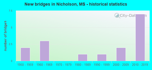
- New bridges - historical statistics
- 21950-1959
- 31960-1969
- 11980-1989
- 11990-1999
- 22000-2009
- 72010-2019


- Bridge Condition - Deck
- 58.3%Very good
- 16.7%Good
- 25.0%Satisfactory

- Bridge Condition - Superstructure
- 50.0%Very good
- 25.0%Good
- 25.0%Satisfactory

- Bridge Condition - Substructure
- 50.0%Very good
- 33.3%Good
- 8.3%Satisfactory
- 8.3%Critical

- Bridge Condition - Channel
- 15.4%Excellent
- 46.2%Very good
- 30.8%Good
- 7.7%Fair

- Bridge Condition - Culverts
- 50.0%Very good
- 50.0%Good
Find on map >> Show street view
Structure Number: 11000590550000A, Location: MISS/LA STATE LINE (Lat: 30.463067, Lng: -89.694744), Route carried "on" structure: Interstate 59, Year Built: 1958, Status: Open, Structure Length: 12.19m (39.99ft), Average Daily Traffic: 14,500 (year 2020), Truck Traffic: 22%, Average Future Daily Traffic: 16,500 (year 2040), Design Load: HS 20, Features Intersected: E. PEARL RIV,FRONTAGE RD
Minimum Vertical Clearance: 30+ m (98+ ft), Kilometerpoint: 66.749, Lanes on structure: 2, Lanes under structure: 2, Base Highway Network: Yes (Inventory Route: 5, Subroute: 2), Owner: State Highway Agency, Approaching Roadway Width: 11.6m (38.1ft), Skew: 10 degrees, Material/Design: Concrete continuous, Design/Construction: Box Beam or Girders - Multiple, Number Of Spans In Main Unit: 3, Number Of Approach Spans: 8, Length of Maximum Span: 27.4m (89.9ft), Curb-To-Curb Width: 8.5m (27.9ft), Out-to-Out Width: 10.1m (33.1ft)
Condition: Deck: Satisfactory, Superstructure: Satisfactory, Substructure: Satisfactory, Channel: Good, Operating Rating: 54.4 metric tons, Method Used To Determine Operating Rating: Load Factor (LF), Inventory Rating: 32.7 metric tons, Method Used To Determine Inventory Rating: Load Factor (LF), Structural Evaluation: Equal to present minimum criteria, Deck Geometry: High priority of corrective action, Underclear: Better than present minimum criteria, Waterway Adequacy: Equal to present desirable criteria, Approach Roadway Alignment: Equal to present desirable criteria, Length Of Structure Improvement: 15.37m (50.43ft), Designated Inspection Frequency: Every 24 months, Underwater Inspection Frequency: Every 60 months, Inspection Date: August 2021, Underwater Inspection Date: September 2019, Bridge Improvement Cost: $999,999,000, Roadway Improvement Cost: $145,000,000, Total Project Cost: $999,999,000, Deck Structure Type: Concrete Cast-file-Place
Find on map >> Show street view
Structure Number: 11000590550000B, Location: MISS/LA STATE LINE (Lat: 30.462089, Lng: -89.695367), Route carried "on" structure: Interstate 59, Year Built: 1958, Status: Open, Structure Length: 12.19m (39.99ft), Average Daily Traffic: 14,500 (year 2020), Truck Traffic: 22%, Average Future Daily Traffic: 16,500 (year 2040), Design Load: HS 20, Features Intersected: E. PEARL RIV,FRONTAGE RD
Minimum Vertical Clearance: 30+ m (98+ ft), Kilometerpoint: 0.002, Lanes on structure: 2, Lanes under structure: 2, Base Highway Network: Yes (Inventory Route: 5, Subroute: 1), Owner: State Highway Agency, Approaching Roadway Width: 11.6m (38.1ft), Skew: 10 degrees, Material/Design: Concrete continuous, Design/Construction: Box Beam or Girders - Multiple, Number Of Spans In Main Unit: 3, Number Of Approach Spans: 8, Length of Maximum Span: 27.4m (89.9ft), Curb-To-Curb Width: 8.5m (27.9ft), Out-to-Out Width: 10.1m (33.1ft)
Condition: Deck: Satisfactory, Superstructure: Satisfactory, Substructure: Good, Channel: Good, Operating Rating: 54.4 metric tons, Method Used To Determine Operating Rating: Load Factor (LF), Inventory Rating: 32.7 metric tons, Method Used To Determine Inventory Rating: Load Factor (LF), Structural Evaluation: Equal to present minimum criteria, Deck Geometry: High priority of corrective action, Underclear: Equal to present minimum criteria, Waterway Adequacy: Equal to present desirable criteria, Approach Roadway Alignment: Equal to present desirable criteria, Length Of Structure Improvement: 15.37m (50.43ft), Designated Inspection Frequency: Every 24 months, Underwater Inspection Frequency: Every 60 months, Inspection Date: August 2021, Underwater Inspection Date: September 2019, Bridge Improvement Cost: $999,999,000, Roadway Improvement Cost: $145,000,000, Total Project Cost: $999,999,000, Deck Structure Type: Concrete Cast-file-Place
Find on map >> Show street view
Structure Number: 31006070230175A, Location: 1.0 MI S PEARL RIVER CL (Lat: 30.447808, Lng: -89.668175), Route carried "on" structure: State highway 607, Year Built: 2015, Status: Open, Structure Length: 3.71m (12.17ft), Average Daily Traffic: 1,450 (year 2020), Truck Traffic: 11%, Average Future Daily Traffic: 1,800 (year 2040), Design Load: HL 93, Features Intersected: INDIAN CAMP BRANCH
Minimum Vertical Clearance: 30+ m (98+ ft), Kilometerpoint: 1.553, Lanes on structure: 2, Owner: State Highway Agency, Approaching Roadway Width: 12.2m (40.0ft), Material/Design: Prestressed concrete continuous, Design/Construction: Stringer/Multi-beam, Number Of Spans In Main Unit: 3, Length of Maximum Span: 12.2m (40.0ft), Curb-To-Curb Width: 12.2m (40.0ft), Out-to-Out Width: 13.0m (42.7ft)
Condition: Deck: Very good, Superstructure: Very good, Substructure: Very good, Channel: Very good, Operating Rating: 54.6 metric tons, Method Used To Determine Operating Rating: Load and Resistance Factor (LRFR), Inventory Rating: 42.1 metric tons, Method Used To Determine Inventory Rating: Load and Resistance Factor (LRFR), Structural Evaluation: Equal to present desirable criteria, Deck Geometry: Better than present minimum criteria, Waterway Adequacy: Superior to present desirable criteria, Approach Roadway Alignment: Equal to present desirable criteria, Designated Inspection Frequency: Every 24 months, Inspection Date: Febuary 2021, Deck Structure Type: Concrete Cast-file-Place
Find on map >> Show street view
Structure Number: 31006070230175B, Location: 1.0 MI S PEARL RIVER CL (Lat: 30.447800, Lng: -89.667753), Route carried "on" structure: State highway 607, Year Built: 2016, Status: Open, Structure Length: 3.71m (12.17ft), Average Daily Traffic: 1,450 (year 2020), Truck Traffic: 11%, Average Future Daily Traffic: 1,800 (year 2040), Design Load: HL 93, Features Intersected: INDIAN CAMP BRANCH
Minimum Vertical Clearance: 30+ m (98+ ft), Kilometerpoint: 12.563, Lanes on structure: 2, Owner: State Highway Agency, Approaching Roadway Width: 12.2m (40.0ft), Material/Design: Prestressed concrete, Design/Construction: Stringer/Multi-beam, Number Of Spans In Main Unit: 3, Length of Maximum Span: 12.2m (40.0ft), Curb-To-Curb Width: 12.2m (40.0ft), Out-to-Out Width: 13.0m (42.7ft)
Condition: Deck: Very good, Superstructure: Very good, Substructure: Very good, Channel: Very good, Operating Rating: 54.6 metric tons, Method Used To Determine Operating Rating: Load and Resistance Factor (LRFR), Inventory Rating: 42.1 metric tons, Method Used To Determine Inventory Rating: Load and Resistance Factor (LRFR), Structural Evaluation: Equal to present desirable criteria, Deck Geometry: Better than present minimum criteria, Waterway Adequacy: Superior to present desirable criteria, Approach Roadway Alignment: Equal to present desirable criteria, Designated Inspection Frequency: Every 24 months, Inspection Date: Febuary 2021, Deck Structure Type: Concrete Cast-file-Place
Find on map >> Show street view
Structure Number: 31006070230184A, Location: 0.1 MI S PEARL RIVER CL (Lat: 30.458119, Lng: -89.676467), Route carried "on" structure: State highway 607, Year Built: 2015, Status: Open, Structure Length: 5.55m (18.21ft), Average Daily Traffic: 1,450 (year 2020), Truck Traffic: 11%, Average Future Daily Traffic: 1,800 (year 2040), Design Load: HL 93, Features Intersected: SECOND ALLIGATOR BRANCH
Minimum Vertical Clearance: 30+ m (98+ ft), Kilometerpoint: 0.153, Lanes on structure: 2, Owner: State Highway Agency, Approaching Roadway Width: 12.2m (40.0ft), Skew: 4 degrees, Material/Design: Prestressed concrete, Design/Construction: Stringer/Multi-beam, Number Of Spans In Main Unit: 1, Number Of Approach Spans: 2, Length of Maximum Span: 30.3m (99.4ft), Curb-To-Curb Width: 12.2m (40.0ft), Out-to-Out Width: 13.0m (42.7ft)
Condition: Deck: Very good, Superstructure: Very good, Substructure: Very good, Channel: Very good, Operating Rating: 63.7 metric tons, Method Used To Determine Operating Rating: Load and Resistance Factor (LRFR), Inventory Rating: 49.2 metric tons, Method Used To Determine Inventory Rating: Load and Resistance Factor (LRFR), Structural Evaluation: Equal to present desirable criteria, Deck Geometry: Better than present minimum criteria, Waterway Adequacy: Superior to present desirable criteria, Approach Roadway Alignment: Equal to present desirable criteria, Designated Inspection Frequency: Every 24 months, Inspection Date: Febuary 2021, Deck Structure Type: Concrete Cast-file-Place
Find on map >> Show street view
Structure Number: 31006070230184B, Location: 0.1 MI S PEARL RIVER CL (Lat: 30.458094, Lng: -89.675997), Route carried "on" structure: State highway 607, Year Built: 2016, Status: Open, Structure Length: 5.54m (18.18ft), Average Daily Traffic: 1,450 (year 2020), Truck Traffic: 11%, Average Future Daily Traffic: 1,800 (year 2040), Design Load: HL 93, Features Intersected: SECOND ALLIGATOR BRANCH
Minimum Vertical Clearance: 30+ m (98+ ft), Kilometerpoint: 13.959, Lanes on structure: 2, Owner: State Highway Agency, Approaching Roadway Width: 12.2m (40.0ft), Skew: 3 degrees, Material/Design: Prestressed concrete, Design/Construction: Stringer/Multi-beam, Number Of Spans In Main Unit: 1, Number Of Approach Spans: 2, Length of Maximum Span: 30.5m (100.1ft), Curb-To-Curb Width: 12.2m (40.0ft), Out-to-Out Width: 13.0m (42.7ft)
Condition: Deck: Very good, Superstructure: Very good, Substructure: Very good, Channel: Very good, Operating Rating: 59.5 metric tons, Method Used To Determine Operating Rating: Load and Resistance Factor (LRFR), Inventory Rating: 45.9 metric tons, Method Used To Determine Inventory Rating: Load and Resistance Factor (LRFR), Structural Evaluation: Equal to present desirable criteria, Deck Geometry: Better than present minimum criteria, Waterway Adequacy: Superior to present desirable criteria, Approach Roadway Alignment: Equal to present desirable criteria, Designated Inspection Frequency: Every 24 months, Inspection Date: Febuary 2021, Deck Structure Type: Concrete Cast-file-Place
Find on map >> Show street view
Structure Number: 3100607055019, Location: 0.4 MI N HANCOCK CL (Lat: 30.462869, Lng: -89.681739), Route carried "on" structure: State highway 607, Year Built: 2015, Status: Open, Structure Length: 4.89m (16.04ft), Average Daily Traffic: 5,100 (year 2020), Truck Traffic: 11%, Average Future Daily Traffic: 5,100 (year 2040), Design Load: HL 93, Features Intersected: FIRST ALLIGATOR BRANCH
Minimum Vertical Clearance: 30+ m (98+ ft), Kilometerpoint: 0.605, Lanes on structure: 4, Owner: State Highway Agency, Approaching Roadway Width: 28.3m (92.8ft), Skew: 21 degrees, Material/Design: Prestressed concrete, Design/Construction: Stringer/Multi-beam, Number Of Spans In Main Unit: 2, Number Of Approach Spans: 1, Length of Maximum Span: 18.3m (60.0ft), Curb-To-Curb Width: 28.3m (92.8ft), Out-to-Out Width: 29.2m (95.8ft)
Condition: Deck: Very good, Superstructure: Very good, Substructure: Very good, Channel: Good, Operating Rating: 54.1 metric tons, Method Used To Determine Operating Rating: Load and Resistance Factor (LRFR), Inventory Rating: 41.7 metric tons, Method Used To Determine Inventory Rating: Load and Resistance Factor (LRFR), Structural Evaluation: Equal to present desirable criteria, Deck Geometry: Superior to present desirable criteria, Waterway Adequacy: Superior to present desirable criteria, Approach Roadway Alignment: Equal to present desirable criteria, Designated Inspection Frequency: Every 24 months, Inspection Date: November 2020, Deck Structure Type: Concrete Cast-file-Place
Find on map >> Show street view
Structure Number: 31006070550194, Location: SR 607 OVER I 59 (Lat: 30.469494, Lng: -89.687639), Route carried "on" structure: State highway 607, Year Built: 1963, Status: Open, Structure Length: 8.05m (26.41ft), Average Daily Traffic: 5,100 (year 2020), Truck Traffic: 11%, Average Future Daily Traffic: 5,100 (year 2040), Design Load: HS 20+Mod, Features Intersected: I 59
Minimum Vertical Clearance: 30+ m (98+ ft), Kilometerpoint: 1.537, Lanes on structure: 2, Lanes under structure: 4, Owner: State Highway Agency, Approaching Roadway Width: 12.2m (40.0ft), Material/Design: Prestressed concrete, Design/Construction: Stringer/Multi-beam, Number Of Spans In Main Unit: 2, Number Of Approach Spans: 2, Length of Maximum Span: 21.3m (69.9ft), Curb-To-Curb Width: 8.5m (27.9ft), Out-to-Out Width: 10.0m (32.8ft)
Condition: Deck: Good, Superstructure: Good, Substructure: Good, Operating Rating: 64.4 metric tons, Method Used To Determine Operating Rating: Load Factor (LF), Inventory Rating: 38.5 metric tons, Method Used To Determine Inventory Rating: Load Factor (LF), Structural Evaluation: Better than present minimum criteria, Deck Geometry: Meets minimum limits, Underclear: Meets minimum limits, Approach Roadway Alignment: Equal to present desirable criteria, Length Of Structure Improvement: 8.05m (26.41ft), Designated Inspection Frequency: Every 24 months, Inspection Date: November 2020, Bridge Improvement Cost: $246,000,000, Roadway Improvement Cost: $130,000,000, Total Project Cost: $436,000,000, Deck Structure Type: Concrete Cast-file-Place
Find on map >> Show street view
Structure Number: SA550000000015, Location: SEC 27 T 6S R17W (Lat: 30.492806, Lng: -89.690000), Route carried "on" structure: County highway 429, Year Built: 1992, Status: Open, Structure Length: 0.85m (2.79ft), Average Daily Traffic: 200 (year 2013), Truck Traffic: 8%, Average Future Daily Traffic: 300 (year 2034), Design Load: HS 20, Features Intersected: ALIGATOR BRANCH, Facility Carried by Structure: SECTION LINE ROAD
Minimum Vertical Clearance: 30+ m (98+ ft), Kilometerpoint: 0.643, Lanes on structure: 2, Owner: County Highway Agency, Approaching Roadway Width: 9.1m (29.9ft), Skew: 1 degrees, Material/Design: Concrete, Design/Construction: Culvert, Number Of Spans In Main Unit: 2, Length of Maximum Span: 3.7m (12.1ft)
Condition: Channel: Very good, Culverts: Very good, Operating Rating: 49.7 metric tons, Method Used To Determine Operating Rating: Load Factor (LF), Inventory Rating: 29.8 metric tons, Method Used To Determine Inventory Rating: Load Factor (LF), Structural Evaluation: Better than present minimum criteria, Waterway Adequacy: Equal to present desirable criteria, Approach Roadway Alignment: Equal to present desirable criteria, Designated Inspection Frequency: Every 24 months, Inspection Date: June 2020
Find on map >> Show street view
Structure Number: SA5500000000152, Location: SEC 34 T 6S R17W (Lat: 30.485247, Lng: -89.690497), Route carried "on" structure: County highway 810, Year Built: 2003, Status: Open, Structure Length: 1.09m (3.58ft), Average Daily Traffic: 100 (year 2013), Average Future Daily Traffic: 150 (year 2034), Design Load: HS 20, Features Intersected: CREEK, Facility Carried by Structure: WILLOW BEND MHP
Minimum Vertical Clearance: 30+ m (98+ ft), Kilometerpoint: 0.160, Lanes on structure: 2, Owner: Private, Approaching Roadway Width: 6.1m (20.0ft), Material/Design: Steel, Design/Construction: Culvert, Number Of Spans In Main Unit: 3, Length of Maximum Span: 2.7m (8.9ft)
Condition: Channel: Good, Culverts: Good, Operating Rating: 54.6 metric tons, Method Used To Determine Operating Rating: Load Factor (LF), Inventory Rating: 32.7 metric tons, Method Used To Determine Inventory Rating: Load Factor (LF), Structural Evaluation: Better than present minimum criteria, Waterway Adequacy: Better than present minimum criteria, Approach Roadway Alignment: Better than present minimum criteria, Length Of Structure Improvement: 1.74m (5.71ft), Designated Inspection Frequency: Every 24 months, Inspection Date: June 2020, Bridge Improvement Cost: $62,000, Roadway Improvement Cost: $20,000, Total Project Cost: $91,000
Find on map >> Show street view
Structure Number: SA5500000000153, Location: SEC 34 T 6S R17W (Lat: 30.479269, Lng: -89.689933), Route carried "on" structure: County highway 240, Year Built: 1981, Status: Closed, Structure Length: 1.74m (5.71ft), Average Daily Traffic: 200 (year 2021), Truck Traffic: 8%, Average Future Daily Traffic: 300 (year 2041), Design Load: H 15, Features Intersected: ALLIGATOR BRANCH, Facility Carried by Structure: SHORTY BURGESS RD
Minimum Vertical Clearance: 30+ m (98+ ft), Kilometerpoint: 0.321, Lanes on structure: 2, Owner: County Highway Agency, Approaching Roadway Width: 6.1m (20.0ft), Material/Design: Concrete, Design/Construction: Channel Beam, Number Of Spans In Main Unit: 3, Length of Maximum Span: 5.8m (19.0ft), Curb or Sidewalk Widths: Left: 0.2m (0.7ft), Right: 0.2m (0.7ft), Curb-To-Curb Width: 6.0m (19.7ft), Out-to-Out Width: 6.5m (21.3ft)
Condition: Deck: Satisfactory, Superstructure: Satisfactory, Substructure: Critical, Channel: Fair, Deck Geometry: High priority of corrective action, Waterway Adequacy: Better than present minimum criteria, Approach Roadway Alignment: Better than present minimum criteria, Bridge Posting: Required (Relationship of Operating Rating to Maximum Legal Load: > 39.9% below), Length Of Structure Improvement: 2.83m (9.28ft), Designated Inspection Frequency: Every 12 months, Inspection Date: January 2021, Bridge Improvement Cost: $101,000, Roadway Improvement Cost: $20,000, Total Project Cost: $135,000, Deck Structure Type: Concrete Precast Panels, Wearing Surface/Protective System: Wearing Surface: Monolithic Concrete
Find on map >> Show street view
Structure Number: SA5500000000155, Location: SEC 2 T 7S R17W (Lat: 30.464583, Lng: -89.675944), Route carried "on" structure: County highway 243, Year Built: 2008, Status: Open, Structure Length: 2.10m (6.89ft), Average Daily Traffic: 100 (year 2013), Average Future Daily Traffic: 150 (year 2034), Design Load: HS 20, Features Intersected: SECOND ALLIGATOR BR, Facility Carried by Structure: ASA MCQUEEN ROAD
Minimum Vertical Clearance: 30+ m (98+ ft), Kilometerpoint: 1.770, Lanes on structure: 2, Owner: County Highway Agency, Approaching Roadway Width: 6.1m (20.0ft), Material/Design: Concrete, Design/Construction: Channel Beam, Number Of Spans In Main Unit: 3, Length of Maximum Span: 9.4m (30.8ft), Curb or Sidewalk Widths: Left: 0.2m (0.7ft), Right: 0.2m (0.7ft), Curb-To-Curb Width: 8.1m (26.6ft), Out-to-Out Width: 8.5m (27.9ft)
Condition: Deck: Very good, Superstructure: Very good, Substructure: Very good, Channel: Excellent, Operating Rating: 75.8 metric tons, Method Used To Determine Operating Rating: Load Factor (LF), Inventory Rating: 45.4 metric tons, Method Used To Determine Inventory Rating: Load Factor (LF), Structural Evaluation: Equal to present desirable criteria, Deck Geometry: Equal to present minimum criteria, Waterway Adequacy: Equal to present desirable criteria, Approach Roadway Alignment: Equal to present desirable criteria, Designated Inspection Frequency: Every 24 months, Inspection Date: June 2020, Deck Structure Type: Concrete Precast Panels
Find on map >> Show street view
Structure Number: SA5500000000169, Location: SEC 33 T 6S R17W (Lat: 30.493500, Lng: -89.711383), Route carried "on" structure: County highway 256, Year Built: 2012, Status: Open, Structure Length: 2.10m (6.89ft), Average Daily Traffic: 330 (year 2011), Truck Traffic: 8%, Average Future Daily Traffic: 450 (year 2030), Design Load: HS 20, Features Intersected: MILL CREEK, Facility Carried by Structure: JACKSON LANDING
Minimum Vertical Clearance: 30+ m (98+ ft), Kilometerpoint: 128.700, Lanes on structure: 2, Owner: County Highway Agency, Approaching Roadway Width: 8.5m (27.9ft), Material/Design: Concrete, Design/Construction: Channel Beam, Number Of Spans In Main Unit: 3, Length of Maximum Span: 9.4m (30.8ft), Curb or Sidewalk Widths: Left: 0.2m (0.7ft), Right: 0.2m (0.7ft), Curb-To-Curb Width: 8.1m (26.6ft), Out-to-Out Width: 8.5m (27.9ft)
Condition: Deck: Good, Superstructure: Good, Substructure: Good, Channel: Excellent, Operating Rating: 78.1 metric tons, Method Used To Determine Operating Rating: Load Factor (LF), Inventory Rating: 46.7 metric tons, Method Used To Determine Inventory Rating: Load Factor (LF), Structural Evaluation: Better than present minimum criteria, Deck Geometry: Somewhat better than minimum adequacy, Waterway Adequacy: Better than present minimum criteria, Approach Roadway Alignment: Equal to present desirable criteria, Designated Inspection Frequency: Every 24 months, Inspection Date: April 2021, Deck Structure Type: Concrete Precast Panels
Find on map >> Show street view
Structure Number: SA550000000A159, Location: SEC 39 T 6S R17W (Lat: 30.486408, Lng: -89.691344), Route carried "on" structure: County highway 276, Year Built: 2014, Status: Open, Structure Length: 2.10m (6.89ft), Average Daily Traffic: 30 (year 2019), Average Future Daily Traffic: 40 (year 2041), Design Load: HL 93, Features Intersected: ALLIGATOR BRANCH, Facility Carried by Structure: J.J. HOLCOMB ROAD
Minimum Vertical Clearance: 30+ m (98+ ft), Kilometerpoint: 1200.000, Lanes on structure: 2, Owner: County Highway Agency, Approaching Roadway Width: 61.0m (200.1ft), Skew: 3 degrees, Material/Design: Concrete, Design/Construction: Channel Beam, Number Of Spans In Main Unit: 3, Length of Maximum Span: 9.5m (31.2ft), Curb or Sidewalk Widths: Left: 2.0m (6.6ft), Right: 2.0m (6.6ft), Curb-To-Curb Width: 73.0m (239.5ft), Out-to-Out Width: 78.0m (255.9ft)
Condition: Deck: Very good, Superstructure: Good, Substructure: Good, Channel: Very good, Operating Rating: 43.7 metric tons, Method Used To Determine Operating Rating: Load and Resistance Factor Rating (LRFR) rating reported by rating factor(RF) method using HL-93 loadings, Inventory Rating: 33.7 metric tons, Method Used To Determine Inventory Rating: Load and Resistance Factor Rating (LRFR) rating reported by rating factor(RF) method using HL-93 loadings, Structural Evaluation: Better than present minimum criteria, Deck Geometry: Superior to present desirable criteria, Waterway Adequacy: Equal to present desirable criteria, Approach Roadway Alignment: Equal to present desirable criteria, Designated Inspection Frequency: Every 24 months, Inspection Date: May 2021, Deck Structure Type: Concrete Precast Panels
Find on map >> Show street view
Structure Number: 31006070550194, Location: SR 607 OVER I 59 (Lat: 30.469494, Lng: -89.687639), Route carried "under" structure: US 59, Year Built: 1963, Structure Length: 0. m, Average Daily Traffic: 13,000 (year 2017), Truck Traffic: 10%, Features Intersected: I 59, Facility Carried by Structure: SR 607
Minimum Vertical Clearance: 4.95m (16.24ft), Kilometerpoint: 1.534, Lanes on structure: 2, Lanes under structure: 4, Material/Design: Prestressed concrete, Design/Construction: Stringer/Multi-beam, Length of Maximum Span: 21.3m (69.9ft)
Find on map >> Show street view
Structure Number: 31006070550194, Location: SR 607 OVER I 59 (Lat: 30.469494, Lng: -89.687639), Route carried "under" structure: US 59, Year Built: 1963, Structure Length: 0. m, Average Daily Traffic: 13,000 (year 2017), Truck Traffic: 10%, Features Intersected: I 59, Facility Carried by Structure: SR 607
Minimum Vertical Clearance: 4.94m (16.21ft), Kilometerpoint: 1.534, Lanes on structure: 2, Lanes under structure: 4, Material/Design: Prestressed concrete, Design/Construction: Stringer/Multi-beam, Length of Maximum Span: 21.3m (69.9ft)