Bridge Statistics for Nikiski, Alaska (AK)
Condition, Traffic, Stress, Structural Evaluation, Project Costs
- National Bridge Inventory (NBI) Statistics
- 11Number of bridges
- 249ft / 75.7mTotal length
- 61,343Total average daily traffic
- 3,329Total average daily truck traffic
- National Bridge Inventory (NBI) Registered Bridges for Nikiski
- No street view available for this location
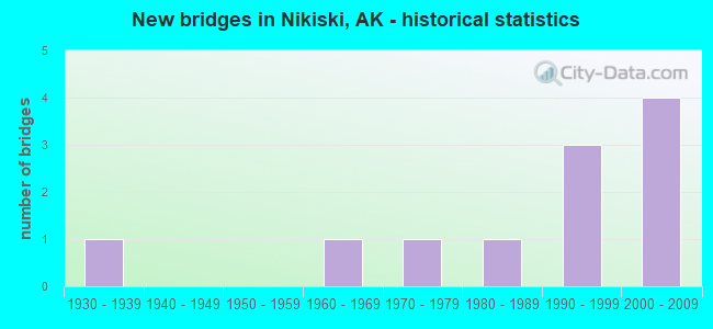
- New bridges - historical statistics
- 11930-1939
- 11960-1969
- 11970-1979
- 11980-1989
- 31990-1999
- 42000-2009


- Bridge Condition - Deck
- 33.3%Very good
- 44.4%Good
- 22.2%Satisfactory

- Bridge Condition - Superstructure
- 22.2%Very good
- 66.7%Good
- 11.1%Satisfactory

- Bridge Condition - Substructure
- 33.3%Very good
- 11.1%Good
- 22.2%Satisfactory
- 33.3%Fair

- Bridge Condition - Channel
- 57.1%Very good
- 28.6%Good
- 14.3%Fair
Find on map >> Show street view
Structure Number: 205, Location: MILE POINT 34.7 (Lat: 61.525833, Lng: -144.411667), Route carried "on" structure: State highway 850, Year Built: 1971, Status: Open, Structure Length: 42.01m (137.83ft), Average Daily Traffic: 180 (year 2020), Truck Traffic: 11%, Average Future Daily Traffic: 220 (year 2039), Design Load: HS 20, Features Intersected: COPPER RIVER (CHITINA), Facility Carried by Structure: EDGERTON/MCCARTHY
Minimum Vertical Clearance: 30+ m (98+ ft), Kilometerpoint: 55.832, Lanes on structure: 2, Owner: State Highway Agency, Approaching Roadway Width: 9.8m (32.2ft), Material/Design: Steel continuous, Design/Construction: Stringer/Multi-beam, Number Of Spans In Main Unit: 8, Length of Maximum Span: 94.5m (310.0ft), Curb-To-Curb Width: 9.1m (29.9ft), Out-to-Out Width: 9.4m (30.8ft)
Condition: Deck: Good, Superstructure: Very good, Substructure: Fair, Channel: Good, Operating Rating: 75.6 metric tons, Method Used To Determine Operating Rating: Load Factor (LF), Inventory Rating: 31.8 metric tons, Method Used To Determine Inventory Rating: Load Factor (LF), Structural Evaluation: Somewhat better than minimum adequacy, Deck Geometry: Equal to present minimum criteria, Waterway Adequacy: Equal to present desirable criteria, Approach Roadway Alignment: Equal to present desirable criteria, Designated Inspection Frequency: Every 24 months, Underwater Inspection Frequency: Every 60 months, Inspection Date: August 2021, Underwater Inspection Date: September 2020, Deck Structure Type: Concrete Cast-file-Place, Wearing Surface/Protective System: Wearing Surface: Monolithic Concrete
Find on map >> Show street view
Structure Number: 239, Location: MILE POINT 52.4 (Lat: 65.055364, Lng: -146.181631), Route carried "on" structure: State highway 650, Year Built: 1967, Year Reconstructed: 1976, Status: Open, Structure Length: 4.94m (16.21ft), Average Daily Traffic: 530 (year 2020), Truck Traffic: 9%, Average Future Daily Traffic: 1,710 (year 2039), Design Load: HS 20, Features Intersected: WEST FORK CHENA RIVER, Facility Carried by Structure: CHENA HOT SPR RD
Minimum Vertical Clearance: 5.03m (16.50ft), Kilometerpoint: 84.312, Lanes on structure: 2, Owner: State Highway Agency, Approaching Roadway Width: 8.2m (26.9ft), Material/Design: Steel, Design/Construction: Stringer/Multi-beam, Number Of Spans In Main Unit: 2, Length of Maximum Span: 24.1m (79.1ft), Curb-To-Curb Width: 8.1m (26.6ft), Out-to-Out Width: 9.0m (29.5ft)
Condition: Deck: Good, Superstructure: Good, Substructure: Satisfactory, Channel: Good, Operating Rating: 63.2 metric tons, Method Used To Determine Operating Rating: Load Factor (LF), Inventory Rating: 29.1 metric tons, Method Used To Determine Inventory Rating: Load Factor (LF), Structural Evaluation: Equal to present minimum criteria, Deck Geometry: Somewhat better than minimum adequacy, Waterway Adequacy: Equal to present minimum criteria, Approach Roadway Alignment: Equal to present desirable criteria, Designated Inspection Frequency: Every 24 months, Inspection Date: August 2020, Deck Structure Type: Concrete Cast-file-Place, Wearing Surface/Protective System: Wearing Surface: Monolithic Concrete
Find on map >> Show street view
Structure Number: 314, Location: MILE POINT 0.1 (Lat: 58.302300, Lng: -134.419100), Route carried "on" structure: City street NSPCY, Year Built: 1934, Status: Open, Structure Length: 1.43m (4.69ft), Average Daily Traffic: 953 (year 2019), Truck Traffic: 2%, Average Future Daily Traffic: 1,000 (year 2035), Features Intersected: GOLD CREEK NINTH ST, Facility Carried by Structure: 9TH STREET
Minimum Vertical Clearance: 30+ m (98+ ft), Kilometerpoint: 0.161, Lanes on structure: 2, Owner: City or Municipal Highway Agency, Approaching Roadway Width: 9.1m (29.9ft), Skew: 4 degrees, Material/Design: Concrete, Design/Construction: Tee Beam, Number Of Spans In Main Unit: 1, Length of Maximum Span: 13.1m (43.0ft), Curb or Sidewalk Widths: Left: 1.5m (4.9ft), Right: 1.5m (4.9ft), Curb-To-Curb Width: 7.3m (24.0ft), Out-to-Out Width: 10.9m (35.8ft)
Condition: Deck: Good, Superstructure: Good, Substructure: Satisfactory, Channel: Very good, Operating Rating: 42.9 metric tons, Method Used To Determine Operating Rating: Load Factor (LF), Inventory Rating: 16.4 metric tons, Method Used To Determine Inventory Rating: Load Factor (LF), Structural Evaluation: Meets minimum limits, Deck Geometry: Meets minimum limits, Waterway Adequacy: Equal to present desirable criteria, Approach Roadway Alignment: Equal to present minimum criteria, Designated Inspection Frequency: Every 24 months, Inspection Date: June 2021, Deck Structure Type: Concrete Cast-file-Place, Wearing Surface/Protective System: Wearing Surface: Bituminous
Find on map >> Show street view
Structure Number: 16, Location: MILE POINT 0.2 (Lat: 61.342200, Lng: -149.565700), Route carried "on" structure: State highway , Year Built: 1991, Status: Open, Structure Length: 8.35m (27.40ft), Average Daily Traffic: 6,730 (year 2020), Truck Traffic: 17%, Average Future Daily Traffic: 8,390 (year 2039), Design Load: HS 20, Features Intersected: NORTH EAGLE RIVER O.C., Facility Carried by Structure: EAGLE RIVER ACCESS
Minimum Vertical Clearance: 4.98m (16.34ft), Kilometerpoint: 0.290, Lanes on structure: 5, Lanes under structure: 4, Owner: State Highway Agency, Approaching Roadway Width: 24.4m (80.1ft), Skew: 30 degrees, Material/Design: Prestressed concrete, Design/Construction: Tee Beam, Number Of Spans In Main Unit: 2, Length of Maximum Span: 41.3m (135.5ft), Curb or Sidewalk Widths: Left: 0.0m, Right: 1.8m (5.9ft), Curb-To-Curb Width: 23.2m (76.1ft), Out-to-Out Width: 27.9m (91.5ft)
Condition: Deck: Satisfactory, Superstructure: Good, Substructure: Fair, Operating Rating: 82.9 metric tons, Method Used To Determine Operating Rating: Load Factor (LF), Inventory Rating: 38.2 metric tons, Method Used To Determine Inventory Rating: Load Factor (LF), Structural Evaluation: Somewhat better than minimum adequacy, Deck Geometry: Better than present minimum criteria, Underclear: Equal to present minimum criteria, Approach Roadway Alignment: Equal to present desirable criteria, Designated Inspection Frequency: Every 24 months, Inspection Date: July 2021, Deck Structure Type: Other, Wearing Surface/Protective System: Wearing Surface: Bituminous, Deck Protection: Epoxy Coated Reinforcing
Find on map >> Show street view
Structure Number: 1831, Location: MATSU BOROUGH (Lat: 61.775261, Lng: -149.910222), Route carried "on" structure: Spur County highway , Year Built: 1987, Year Reconstructed: 2021, Status: Open, Structure Length: 7.69m (25.23ft), Average Daily Traffic: 20 (year 2018), Truck Traffic: 1%, Average Future Daily Traffic: 25 (year 2035), Design Load: HS 20, Features Intersected: WILLOW CREEK, Facility Carried by Structure: SHIRLEY TOWNE DR
Minimum Vertical Clearance: 30+ m (98+ ft), Kilometerpoint: 0.483, Lanes on structure: 1, Owner: County Highway Agency, Approaching Roadway Width: 4.0m (13.1ft), Material/Design: Steel, Design/Construction: Stringer/Multi-beam, Number Of Spans In Main Unit: 5, Length of Maximum Span: 23.5m (77.1ft), Curb-To-Curb Width: 3.0m (9.8ft), Out-to-Out Width: 4.4m (14.4ft)
Condition: Deck: Satisfactory, Superstructure: Satisfactory, Substructure: Fair, Channel: Fair, Operating Rating: 72.5 metric tons, Method Used To Determine Operating Rating: Load Factor (LF), Inventory Rating: 27.7 metric tons, Method Used To Determine Inventory Rating: Load Factor (LF), Structural Evaluation: Somewhat better than minimum adequacy, Deck Geometry: High priority of replacement, Waterway Adequacy: Better than present minimum criteria, Approach Roadway Alignment: Better than present minimum criteria, Designated Inspection Frequency: Every 24 months, Critical Feature Inspection Frequency: Every 24 months, Inspection Date: May 2021, Critical Feature Inspection Date: May 2021, Deck Structure Type: Wood or Timber, Wearing Surface/Protective System: Wearing Surface: Wood or Timber
Find on map >> Show street view
Structure Number: 2034, Location: MILE POINT 2.6 (Lat: 61.567897, Lng: -149.313208), Route carried "on" structure: State highway _, Year Built: 2003, Status: Open, Structure Length: 2.60m (8.53ft), Average Daily Traffic: 13,200 (year 2020), Truck Traffic: 5%, Average Future Daily Traffic: 15,300 (year 2039), Design Load: HS 25 or greater, Features Intersected: HYER RD UC NORTHBOUND, Facility Carried by Structure: PARKS HIGHWAY
Minimum Vertical Clearance: 5.42m (17.78ft), Kilometerpoint: 4.184, Lanes on structure: 2, Lanes under structure: 2, Base Highway Network: Yes, Owner: State Highway Agency, Approaching Roadway Width: 11.6m (38.1ft), Skew: 1 degrees, Material/Design: Prestressed concrete, Design/Construction: Tee Beam, Number Of Spans In Main Unit: 1, Length of Maximum Span: 24.5m (80.4ft), Curb-To-Curb Width: 11.4m (37.4ft), Out-to-Out Width: 12.3m (40.4ft)
Condition: Deck: Very good, Superstructure: Good, Substructure: Good, Inventory Rating: 48.6 metric tons, Method Used To Determine Inventory Rating: Load Factor (LF), Structural Evaluation: Better than present minimum criteria, Deck Geometry: Somewhat better than minimum adequacy, Underclear: Superior to present desirable criteria, Approach Roadway Alignment: Better than present minimum criteria, Designated Inspection Frequency: Every 24 months, Inspection Date: June 2020, Deck Structure Type: Other, Wearing Surface/Protective System: Wearing Surface: Bituminous, Membrane: Preformed Fabric, Deck Protection: Epoxy Coated Reinforcing
Find on map >> Show street view
Structure Number: 2035, Location: MILE POINT 3.1 (Lat: 61.567494, Lng: -149.314203), Route carried "on" structure: ServiceState highway , Year Built: 2002, Status: Open, Structure Length: 2.35m (7.71ft), Average Daily Traffic: 5,100 (year 2020), Truck Traffic: 6%, Average Future Daily Traffic: 6,100 (year 2039), Design Load: HS 25 or greater, Features Intersected: WASILLA CR S FRONTAGE, Facility Carried by Structure: EAST FIREWEED ROAD
Minimum Vertical Clearance: 30+ m (98+ ft), Kilometerpoint: 4.923, Lanes on structure: 2, Owner: State Highway Agency, Approaching Roadway Width: 10.4m (34.1ft), Material/Design: Prestressed concrete, Design/Construction: Tee Beam, Number Of Spans In Main Unit: 1, Length of Maximum Span: 22.0m (72.2ft), Curb-To-Curb Width: 10.2m (33.5ft), Out-to-Out Width: 11.1m (36.4ft)
Condition: Deck: Very good, Superstructure: Very good, Substructure: Very good, Channel: Very good, Inventory Rating: 52.9 metric tons, Method Used To Determine Inventory Rating: Load Factor (LF), Structural Evaluation: Equal to present desirable criteria, Deck Geometry: Meets minimum limits, Waterway Adequacy: Equal to present desirable criteria, Approach Roadway Alignment: Better than present minimum criteria, Designated Inspection Frequency: Every 24 months, Inspection Date: June 2020, Deck Structure Type: Other, Wearing Surface/Protective System: Wearing Surface: Bituminous, Membrane: Preformed Fabric, Deck Protection: Epoxy Coated Reinforcing
Find on map >> Show street view
Structure Number: 2036, Location: MILE POINT 0.1 (Lat: 61.568478, Lng: -149.314194), Route carried "on" structure: ServiceState highway , Year Built: 2002, Status: Open, Structure Length: 3.57m (11.71ft), Average Daily Traffic: 1,190 (year 2020), Truck Traffic: 5%, Average Future Daily Traffic: 1,780 (year 2039), Design Load: HS 25 or greater, Features Intersected: WASILLA CR NB RAMP, Facility Carried by Structure: NB RAMP
Minimum Vertical Clearance: 5.31m (17.42ft), Kilometerpoint: 0.161, Lanes on structure: 1, Owner: State Highway Agency, Approaching Roadway Width: 7.3m (24.0ft), Skew: 3 degrees, Material/Design: Prestressed concrete, Design/Construction: Tee Beam, Number Of Spans In Main Unit: 1, Length of Maximum Span: 34.2m (112.2ft), Curb-To-Curb Width: 7.2m (23.6ft), Out-to-Out Width: 8.1m (26.6ft)
Condition: Deck: Very good, Superstructure: Good, Substructure: Very good, Channel: Very good, Operating Rating: 77.1 metric tons, Method Used To Determine Operating Rating: Load Factor (LF), Inventory Rating: 35.6 metric tons, Method Used To Determine Inventory Rating: Load Factor (LF), Structural Evaluation: Better than present minimum criteria, Deck Geometry: High priority of corrective action, Waterway Adequacy: Better than present minimum criteria, Approach Roadway Alignment: Better than present minimum criteria, Designated Inspection Frequency: Every 24 months, Inspection Date: June 2020, Deck Structure Type: Other, Wearing Surface/Protective System: Wearing Surface: Bituminous, Membrane: Preformed Fabric, Deck Protection: Epoxy Coated Reinforcing
Find on map >> Show street view
Structure Number: 2079, Location: MILE POINT 6.0 (Lat: 56.799600, Lng: -132.895000), Route carried "on" structure: City street , Year Built: 2000, Status: Open, Structure Length: 2.74m (8.99ft), Average Daily Traffic: 10 (year 2018), Truck Traffic: 1%, Average Future Daily Traffic: 14 (year 2035), Design Load: HS 20, Features Intersected: CITY CREEK, Facility Carried by Structure: FREDRICK DRIVE
Minimum Vertical Clearance: 30+ m (98+ ft), Kilometerpoint: 9.656, Lanes on structure: 2, Owner: County Highway Agency, Approaching Roadway Width: 8.5m (27.9ft), Material/Design: Steel, Design/Construction: Stringer/Multi-beam, Number Of Spans In Main Unit: 1, Length of Maximum Span: 26.8m (87.9ft), Curb-To-Curb Width: 7.6m (24.9ft), Out-to-Out Width: 7.6m (24.9ft)
Condition: Deck: Good, Superstructure: Good, Substructure: Very good, Channel: Very good, Operating Rating: 50.7 metric tons, Method Used To Determine Operating Rating: Load Factor (LF), Inventory Rating: 33.5 metric tons, Method Used To Determine Inventory Rating: Load Factor (LF), Structural Evaluation: Better than present minimum criteria, Deck Geometry: Equal to present minimum criteria, Waterway Adequacy: Superior to present desirable criteria, Approach Roadway Alignment: Equal to present minimum criteria, Designated Inspection Frequency: Every 24 months, Inspection Date: May 2021, Deck Structure Type: Wood or Timber, Wearing Surface/Protective System: Wearing Surface: Wood or Timber
Find on map >> Show street view
Structure Number: 1091, Location: MILE POINT 3.7 (Lat: 61.180833, Lng: -149.807500), Route carried "under" structure: City street U521, Year Built: 1995, Structure Length: 0. m, Average Daily Traffic: 24,700 (year 2020), Truck Traffic: 4%, Features Intersected: TUDOR ROAD POC AT BRAGAW, Facility Carried by Structure: TUDOR RD UNDER
Minimum Vertical Clearance: 5.03m (16.50ft), Kilometerpoint: 6.017, Lanes under structure: 5, Material/Design: Steel, Design/Construction: Box Beam or Girders - Multiple, Length of Maximum Span: 48.8m (160.1ft)
Find on map >> Show street view
Structure Number: 2039, Location: MILE POINT 2.2 (Lat: 61.217500, Lng: -149.893333), Route carried "under" structure: State highway , Year Built: 1998, Structure Length: 0. m, Average Daily Traffic: 8,730 (year 2020), Truck Traffic: 1%, Features Intersected: FIFTH AVE SKYBRIDGE POC, Facility Carried by Structure: FIFTH AVENUE
Minimum Vertical Clearance: 4.90m (16.08ft), Kilometerpoint: 3.589, Lanes under structure: 3, Material/Design: Steel, Design/Construction: Arch - Thru, Length of Maximum Span: 25.9m (85.0ft)