Bridge Statistics for Niles, Michigan (MI)
Condition, Traffic, Stress, Structural Evaluation, Project Costs
- National Bridge Inventory (NBI) Statistics
- 28Number of bridges
- 256ft / 78.3mTotal length
- $790,000Total costs
- 199,015Total average daily traffic
- 10,172Total average daily truck traffic
- National Bridge Inventory (NBI) Registered Bridges for Niles
- No street view available for this location
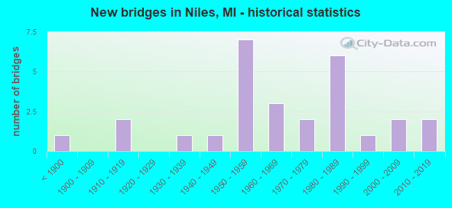
- New bridges - historical statistics
- 1Before 1900
- 21910-1919
- 11930-1939
- 11940-1949
- 71950-1959
- 31960-1969
- 21970-1979
- 61980-1989
- 11990-1999
- 22000-2009
- 22010-2019
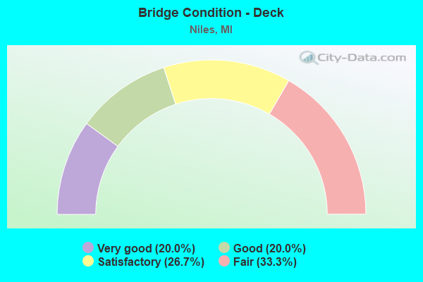
- Bridge Condition - Deck
- 20.0%Very good
- 20.0%Good
- 26.7%Satisfactory
- 33.3%Fair
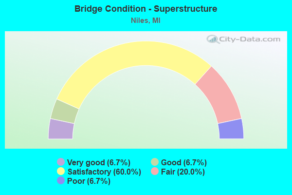
- Bridge Condition - Superstructure
- 6.7%Very good
- 6.7%Good
- 60.0%Satisfactory
- 20.0%Fair
- 6.7%Poor
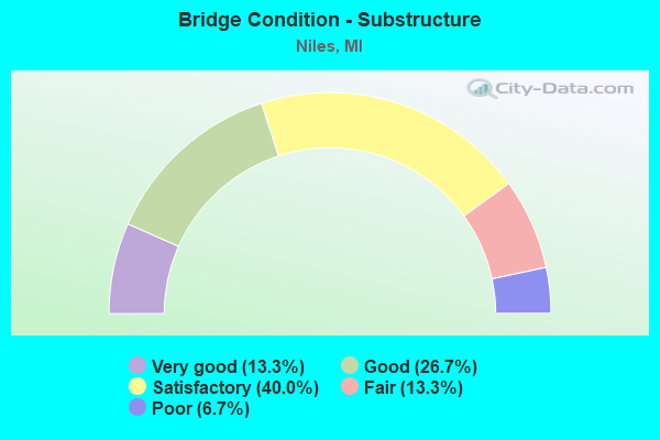
- Bridge Condition - Substructure
- 13.3%Very good
- 26.7%Good
- 40.0%Satisfactory
- 13.3%Fair
- 6.7%Poor
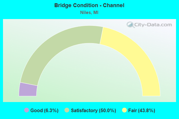
- Bridge Condition - Channel
- 6.3%Good
- 50.0%Satisfactory
- 43.8%Fair
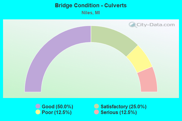
- Bridge Condition - Culverts
- 50.0%Good
- 25.0%Satisfactory
- 12.5%Poor
- 12.5%Serious
Find on map >> Show street view
Structure Number: 857, Location: IN CITY OF NILES (Lat: 41.829839, Lng: -86.259903), Route carried "on" structure: Business State highway 139, Year Built: 2015, Status: Open, Structure Length: 11.22m (36.81ft), Average Daily Traffic: 9,950 (year 2008), Truck Traffic: 3%, Average Future Daily Traffic: 10,520 (year 2035), Design Load: Greater than HL93, Features Intersected: ST JOSEPH RIVER
Minimum Vertical Clearance: 30.48m (100.00ft), Kilometerpoint: 0.613, Lanes on structure: 2, Base Highway Network: Yes (Inventory Route: 136, Subroute: 1), Owner: State Highway Agency, Approaching Roadway Width: 10.4m (34.1ft), Material/Design: Prestressed concrete, Design/Construction: Stringer/Multi-beam, Number Of Spans In Main Unit: 3, Length of Maximum Span: 36.7m (120.4ft), Curb or Sidewalk Widths: Left: 2.1m (6.9ft), Right: 2.1m (6.9ft), Curb-To-Curb Width: 9.1m (29.9ft), Out-to-Out Width: 14.4m (47.2ft)
Condition: Deck: Very good, Superstructure: Satisfactory, Substructure: Very good, Channel: Fair, Operating Rating: 60.6 metric tons, Method Used To Determine Operating Rating: Load and Resistance Factor Rating (LRFR) rating reported by rating factor(RF) method using HL-93 loadings, Inventory Rating: 34.7 metric tons, Method Used To Determine Inventory Rating: Load and Resistance Factor Rating (LRFR) rating reported by rating factor(RF) method using HL-93 loadings, Structural Evaluation: Equal to present minimum criteria, Deck Geometry: Meets minimum limits, Waterway Adequacy: Equal to present desirable criteria, Approach Roadway Alignment: Meets minimum limits, Designated Inspection Frequency: Every 24 months, Underwater Inspection Frequency: Every 60 months, Inspection Date: July 2020, Underwater Inspection Date: July 2017, Deck Structure Type: Concrete Cast-file-Place, Wearing Surface/Protective System: Wearing Surface: Monolithic Concrete, Deck Protection: Epoxy Coated Reinforcing
Find on map >> Show street view
Structure Number: 872, Location: 0.2 MI N OF US-12 (Lat: 41.804128, Lng: -86.248256), Route carried "on" structure: Business US 31, Year Built: 2005, Status: Open, Structure Length: 0.91m (2.99ft), Average Daily Traffic: 20,190 (year 2007), Truck Traffic: 3%, Average Future Daily Traffic: 23,592 (year 2018), Design Load: HS 25 or greater, Features Intersected: BRANDYWINE CREEK
Minimum Vertical Clearance: 30.48m (100.00ft), Kilometerpoint: 4.881, Lanes on structure: 5, Base Highway Network: Yes (Inventory Route: 136, Subroute: 2), Owner: State Highway Agency, Approaching Roadway Width: 19.4m (63.6ft), Material/Design: Concrete, Design/Construction: Culvert, Number Of Spans In Main Unit: 1, Length of Maximum Span: 8.5m (27.9ft), Curb-To-Curb Width: 19.4m (63.6ft), Out-to-Out Width: 28.5m (93.5ft)
Condition: Channel: Fair, Culverts: Good, Operating Rating: 97.2 metric tons, Method Used To Determine Operating Rating: Load Factor (LF) rating reported by rating factor (RF) method using MS18 loading, Inventory Rating: 63.2 metric tons, Method Used To Determine Inventory Rating: Load Factor (LF) rating reported by rating factor (RF) method using MS18 loading, Structural Evaluation: Better than present minimum criteria, Deck Geometry: Meets minimum limits, Waterway Adequacy: Equal to present desirable criteria, Approach Roadway Alignment: Equal to present desirable criteria, Designated Inspection Frequency: Every 24 months, Inspection Date: March 2020, Wearing Surface/Protective System: Wearing Surface: Monolithic Concrete, Deck Protection: Other Coated Reinforcing
Find on map >> Show street view
Structure Number: 873, Location: 0.76 MI S OF M-140 (Lat: 41.845111, Lng: -86.262586), Route carried "on" structure: Business State highway 139, Year Built: 2012, Status: Open, Structure Length: 5.33m (17.49ft), Average Daily Traffic: 8,000 (year 2011), Truck Traffic: 3%, Average Future Daily Traffic: 9,300 (year 2031), Design Load: HL 93, Features Intersected: DOWAGIAC RIVER
Minimum Vertical Clearance: 30.48m (100.00ft), Kilometerpoint: 1.772, Lanes on structure: 2, Base Highway Network: Yes (Inventory Route: 136, Subroute: 9), Owner: State Highway Agency, Approaching Roadway Width: 12.2m (40.0ft), Skew: 2 degrees, Material/Design: Prestressed concrete, Design/Construction: Box Beam or Girders - Single/Spread, Number Of Spans In Main Unit: 2, Length of Maximum Span: 25.8m (84.6ft), Curb-To-Curb Width: 13.4m (44.0ft), Out-to-Out Width: 14.3m (46.9ft)
Condition: Deck: Good, Superstructure: Satisfactory, Substructure: Good, Channel: Fair, Operating Rating: 59.0 metric tons, Method Used To Determine Operating Rating: Load and Resistance Factor Rating (LRFR) rating reported by rating factor(RF) method using HL-93 loadings, Inventory Rating: 43.7 metric tons, Method Used To Determine Inventory Rating: Load and Resistance Factor Rating (LRFR) rating reported by rating factor(RF) method using HL-93 loadings, Structural Evaluation: Equal to present minimum criteria, Deck Geometry: Equal to present minimum criteria, Waterway Adequacy: Equal to present desirable criteria, Approach Roadway Alignment: Equal to present desirable criteria, Designated Inspection Frequency: Every 24 months, Inspection Date: July 2020, Deck Structure Type: Concrete Cast-file-Place, Wearing Surface/Protective System: Wearing Surface: Monolithic Concrete, Deck Protection: Epoxy Coated Reinforcing
Find on map >> Show street view
Structure Number: 888, Location: 2.0 MI SW OF NILES (Lat: 41.805389, Lng: -86.316239), Route carried "on" structure: US 31, Year Built: 1978, Status: Open, Structure Length: 7.50m (24.61ft), Average Daily Traffic: 9,550 (year 2019), Truck Traffic: 14%, Average Future Daily Traffic: 10,600 (year 2040), Design Load: HS 25 or greater, Features Intersected: US-12
Minimum Vertical Clearance: 30.48m (100.00ft), Kilometerpoint: 5.271, Lanes on structure: 3, Lanes under structure: 6, Base Highway Network: Yes (Inventory Route: 177, Subroute: 3), Owner: State Highway Agency, Approaching Roadway Width: 11.6m (38.1ft), Material/Design: Steel, Design/Construction: Stringer/Multi-beam, Number Of Spans In Main Unit: 2, Length of Maximum Span: 37.5m (123.0ft), Curb-To-Curb Width: 15.9m (52.2ft), Out-to-Out Width: 17.2m (56.4ft)
Condition: Deck: Satisfactory, Superstructure: Satisfactory, Substructure: Good, Operating Rating: 82.6 metric tons, Method Used To Determine Operating Rating: Load Factor (LF) rating reported by rating factor (RF) method using MS18 loading, Inventory Rating: 49.2 metric tons, Method Used To Determine Inventory Rating: Load Factor (LF) rating reported by rating factor (RF) method using MS18 loading, Structural Evaluation: Equal to present minimum criteria, Deck Geometry: Better than present minimum criteria, Underclear: Better than present minimum criteria, Approach Roadway Alignment: Equal to present desirable criteria, Designated Inspection Frequency: Every 24 months, Inspection Date: May 2020, Deck Structure Type: Concrete Cast-file-Place, Wearing Surface/Protective System: Wearing Surface: Latex Concrete, Deck Protection: Epoxy Coated Reinforcing
Find on map >> Show street view
Structure Number: 918, Location: 0.8 MI S OF NILES (Lat: 41.801267, Lng: -86.248297), Route carried "on" structure: US 12, Year Built: 1955, Status: Open, Structure Length: 4.79m (15.72ft), Average Daily Traffic: 7,473 (year 2014), Truck Traffic: 10%, Average Future Daily Traffic: 8,594 (year 2034), Design Load: HS 20, Features Intersected: M-51
Minimum Vertical Clearance: 30.48m (100.00ft), Kilometerpoint: 6.753, Lanes on structure: 2, Lanes under structure: 5, Base Highway Network: Yes (Inventory Route: 311, Subroute: 1), Owner: State Highway Agency, Approaching Roadway Width: 9.8m (32.2ft), Material/Design: Steel, Design/Construction: Stringer/Multi-beam, Number Of Spans In Main Unit: 3, Length of Maximum Span: 24.0m (78.7ft), Curb-To-Curb Width: 10.1m (33.1ft), Out-to-Out Width: 11.9m (39.0ft)
Condition: Deck: Fair, Superstructure: Satisfactory, Substructure: Satisfactory, Operating Rating: 60.6 metric tons, Method Used To Determine Operating Rating: Load Factor (LF) rating reported by rating factor (RF) method using MS18 loading, Inventory Rating: 36.3 metric tons, Method Used To Determine Inventory Rating: Load Factor (LF) rating reported by rating factor (RF) method using MS18 loading, Structural Evaluation: Equal to present minimum criteria, Deck Geometry: Somewhat better than minimum adequacy, Underclear: Somewhat better than minimum adequacy, Approach Roadway Alignment: Equal to present minimum criteria, Length Of Structure Improvement: 4.79m (15.72ft), Designated Inspection Frequency: Every 24 months, Inspection Date: August 2020, Bridge Improvement Cost: $233,000, Roadway Improvement Cost: $6,000, Total Project Cost: $70,000, Deck Structure Type: Concrete Cast-file-Place, Wearing Surface/Protective System: Wearing Surface: Bituminous, Membrane: Preformed Fabric
Find on map >> Show street view
Structure Number: 964, Location: 1.0 MI N OF NILES (Lat: 41.865358, Lng: -86.241936), Route carried "on" structure: County highway 1126, Year Built: 1985, Status: Open, Structure Length: 4.57m (14.99ft), Average Daily Traffic: 2,533 (year 2007), Truck Traffic: 4%, Average Future Daily Traffic: 3,680 (year 2027), Design Load: HS 20, Features Intersected: DOWAGIAC CREEK, Facility Carried by Structure: PUCKER STREET
Minimum Vertical Clearance: 30.48m (100.00ft), Kilometerpoint: 0.542, Lanes on structure: 2, Owner: County Highway Agency, Approaching Roadway Width: 9.1m (29.9ft), Material/Design: Prestressed concrete, Design/Construction: Box Beam or Girders - Multiple, Number Of Spans In Main Unit: 2, Length of Maximum Span: 22.5m (73.8ft), Curb-To-Curb Width: 9.1m (29.9ft), Out-to-Out Width: 10.5m (34.4ft)
Condition: Deck: Good, Superstructure: Satisfactory, Substructure: Satisfactory, Channel: Fair, Operating Rating: 64.8 metric tons, Method Used To Determine Operating Rating: Load Factor (LF) rating reported by rating factor (RF) method using MS18 loading, Inventory Rating: 38.9 metric tons, Method Used To Determine Inventory Rating: Load Factor (LF) rating reported by rating factor (RF) method using MS18 loading, Structural Evaluation: Equal to present minimum criteria, Deck Geometry: Meets minimum limits, Waterway Adequacy: Superior to present desirable criteria, Approach Roadway Alignment: Equal to present desirable criteria, Designated Inspection Frequency: Every 12 months, Inspection Date: June 2021, Deck Structure Type: Concrete Precast Panels, Wearing Surface/Protective System: Wearing Surface: Bituminous, Membrane: Built-up
Find on map >> Show street view
Structure Number: 995, Location: 0.5 MI S OF NILES (Lat: 41.804678, Lng: -86.254475), Route carried "on" structure: County highway 2010, Year Built: 1982, Status: Open, Structure Length: 0.97m (3.18ft), Average Daily Traffic: 5,588 (year 2007), Truck Traffic: 4%, Average Future Daily Traffic: 8,000 (year 2027), Design Load: H 20, Features Intersected: BRANDYWINE CREEK, Facility Carried by Structure: THIRD STREET
Minimum Vertical Clearance: 30.48m (100.00ft), Kilometerpoint: 4.922, Lanes on structure: 2, Owner: County Highway Agency, Approaching Roadway Width: 11.6m (38.1ft), Skew: 2 degrees, Material/Design: Steel, Design/Construction: Culvert, Number Of Spans In Main Unit: 1, Length of Maximum Span: 9.7m (31.8ft)
Condition: Channel: Satisfactory, Culverts: Satisfactory, Operating Rating: 39.2 metric tons, Method Used To Determine Operating Rating: Load Factor (LF) rating reported by rating factor (RF) method using MS18 loading, Inventory Rating: 23.3 metric tons, Method Used To Determine Inventory Rating: Load Factor (LF) rating reported by rating factor (RF) method using MS18 loading, Structural Evaluation: Somewhat better than minimum adequacy, Waterway Adequacy: Better than present minimum criteria, Approach Roadway Alignment: Equal to present desirable criteria, Designated Inspection Frequency: Every 24 months, Inspection Date: June 2020
Find on map >> Show street view
Structure Number: 102, Location: 1 MI W OF NILES (Lat: 41.812958, Lng: -86.293361), Route carried "on" structure: County highway , Year Built: 2004, Status: Open, Structure Length: 5.03m (16.50ft), Average Daily Traffic: 97 (year 2007), Truck Traffic: 4%, Average Future Daily Traffic: 240 (year 2027), Design Load: HS 20, Features Intersected: AMTRAK RAILROAD, Facility Carried by Structure: WEISER ROAD
Minimum Vertical Clearance: 30.48m (100.00ft), Kilometerpoint: 1.370, Lanes on structure: 2, Owner: County Highway Agency, Approaching Roadway Width: 9.1m (29.9ft), Skew: 5 degrees, Material/Design: Prestressed concrete, Design/Construction: Box Beam or Girders - Single/Spread, Number Of Spans In Main Unit: 3, Length of Maximum Span: 21.0m (68.9ft), Curb-To-Curb Width: 9.1m (29.9ft), Out-to-Out Width: 9.8m (32.2ft)
Condition: Deck: Good, Superstructure: Good, Substructure: Good, Operating Rating: 87.8 metric tons, Method Used To Determine Operating Rating: Load Factor (LF) rating reported by rating factor (RF) method using MS18 loading, Inventory Rating: 52.8 metric tons, Method Used To Determine Inventory Rating: Load Factor (LF) rating reported by rating factor (RF) method using MS18 loading, Structural Evaluation: Better than present minimum criteria, Approach Roadway Alignment: Equal to present minimum criteria, Designated Inspection Frequency: Every 24 months, Inspection Date: July 2020, Deck Structure Type: Concrete Cast-file-Place, Wearing Surface/Protective System: Wearing Surface: Monolithic Concrete, Deck Protection: Epoxy Coated Reinforcing
Find on map >> Show street view
Structure Number: 1021, Location: 3 MI N OF NILES (Lat: 41.884581, Lng: -86.224933), Route carried "on" structure: County highway , Year Built: 1959, Status: Open, Structure Length: 1.89m (6.20ft), Average Daily Traffic: 99 (year 2004), Truck Traffic: 4%, Average Future Daily Traffic: 200 (year 2024), Design Load: H 15, Features Intersected: DOWAGIAC RIVER, Facility Carried by Structure: KINZIE ROAD
Minimum Vertical Clearance: 30.48m (100.00ft), Kilometerpoint: 0.447, Lanes on structure: 2, Owner: County Highway Agency, Approaching Roadway Width: 8.5m (27.9ft), Material/Design: Prestressed concrete, Design/Construction: Box Beam or Girders - Multiple, Number Of Spans In Main Unit: 1, Length of Maximum Span: 18.6m (61.0ft), Curb-To-Curb Width: 7.3m (24.0ft), Out-to-Out Width: 7.5m (24.6ft)
Condition: Deck: Satisfactory, Superstructure: Satisfactory, Substructure: Satisfactory, Channel: Satisfactory, Operating Rating: 63.2 metric tons, Method Used To Determine Operating Rating: Load Factor (LF) rating reported by rating factor (RF) method using MS18 loading, Inventory Rating: 37.9 metric tons, Method Used To Determine Inventory Rating: Load Factor (LF) rating reported by rating factor (RF) method using MS18 loading, Structural Evaluation: Equal to present minimum criteria, Deck Geometry: Equal to present minimum criteria, Waterway Adequacy: Equal to present desirable criteria, Approach Roadway Alignment: Better than present minimum criteria, Length Of Structure Improvement: 1.89m (6.20ft), Designated Inspection Frequency: Every 24 months, Inspection Date: July 2020, Bridge Improvement Cost: $39,000, Roadway Improvement Cost: $11,000, Total Project Cost: $50,000, Deck Structure Type: Other, Wearing Surface/Protective System: Wearing Surface: Bituminous
Find on map >> Show street view
Structure Number: 1022, Location: 0.25 MI S OF NILES (Lat: 41.809839, Lng: -86.239828), Route carried "on" structure: County highway , Year Built: 1993, Status: Open, Structure Length: 1.03m (3.38ft), Average Daily Traffic: 614 (year 2007), Truck Traffic: 4%, Average Future Daily Traffic: 880 (year 2027), Design Load: HS 20, Features Intersected: BRANDYWINE CREEK, Facility Carried by Structure: 15TH STREET
Minimum Vertical Clearance: 30.48m (100.00ft), Kilometerpoint: 0.821, Lanes on structure: 2, Owner: County Highway Agency, Approaching Roadway Width: 9.1m (29.9ft), Material/Design: Prestressed concrete, Design/Construction: Box Beam or Girders - Multiple, Number Of Spans In Main Unit: 1, Length of Maximum Span: 9.7m (31.8ft), Curb-To-Curb Width: 9.4m (30.8ft), Out-to-Out Width: 10.4m (34.1ft)
Condition: Deck: Satisfactory, Superstructure: Satisfactory, Substructure: Very good, Channel: Satisfactory, Operating Rating: 50.5 metric tons, Method Used To Determine Operating Rating: Load Factor (LF) rating reported by rating factor (RF) method using MS18 loading, Inventory Rating: 30.1 metric tons, Method Used To Determine Inventory Rating: Load Factor (LF) rating reported by rating factor (RF) method using MS18 loading, Structural Evaluation: Equal to present minimum criteria, Deck Geometry: Equal to present minimum criteria, Waterway Adequacy: Equal to present desirable criteria, Approach Roadway Alignment: Equal to present minimum criteria, Designated Inspection Frequency: Every 24 months, Inspection Date: July 2020, Deck Structure Type: Concrete Cast-file-Place, Wearing Surface/Protective System: Wearing Surface: Bituminous
Find on map >> Show street view
Structure Number: 1023, Location: 0.30 MI S OF NILES (Lat: 41.807903, Lng: -86.245553), Route carried "on" structure: County highway , Year Built: 1950, Status: Posted for load, Structure Length: 0.64m (2.10ft), Average Daily Traffic: 147 (year 2007), Truck Traffic: 4%, Average Future Daily Traffic: 300 (year 2027), Design Load: H 15, Features Intersected: BRANDYWINE CREEK, Facility Carried by Structure: FERNDALE STREET
Minimum Vertical Clearance: 30.48m (100.00ft), Kilometerpoint: 0.542, Lanes on structure: 2, Owner: County Highway Agency, Approaching Roadway Width: 7.3m (24.0ft), Material/Design: Steel, Design/Construction: Culvert, Number Of Spans In Main Unit: 3, Length of Maximum Span: 2.1m (6.9ft), Out-to-Out Width: 9.1m (29.9ft)
Condition: Channel: Satisfactory, Culverts: Serious, Operating Rating: 24.9 metric tons, Method Used To Determine Operating Rating: Load Factor (LF) rating reported by rating factor (RF) method using MS18 loading, Inventory Rating: 14.9 metric tons, Method Used To Determine Inventory Rating: Load Factor (LF) rating reported by rating factor (RF) method using MS18 loading, Structural Evaluation: High priority of corrective action, Waterway Adequacy: Better than present minimum criteria, Approach Roadway Alignment: Equal to present minimum criteria, Bridge Posting: Required (Relationship of Operating Rating to Maximum Legal Load: > 39.9% below), Length Of Structure Improvement: 1.52m (4.99ft), Designated Inspection Frequency: Every 12 months, Inspection Date: July 2021, Bridge Improvement Cost: $470,000, Roadway Improvement Cost: $200,000, Total Project Cost: $670,000
Find on map >> Show street view
Structure Number: 1057, Location: CITY OF NILES (Lat: 41.827192, Lng: -86.269192), Route carried "on" structure: City street 2010, Year Built: 1984, Status: Open, Structure Length: 3.64m (11.94ft), Average Daily Traffic: 7,950 (year 2015), Truck Traffic: 4%, Average Future Daily Traffic: 9,143 (year 2035), Design Load: HS 20+Mod, Features Intersected: AMTRAK RAILROAD, Facility Carried by Structure: GRANT STREET
Minimum Vertical Clearance: 30.48m (100.00ft), Kilometerpoint: 9.843, Lanes on structure: 2, Owner: City or Municipal Highway Agency, Approaching Roadway Width: 8.5m (27.9ft), Skew: 3 degrees, Material/Design: Prestressed concrete, Design/Construction: Box Beam or Girders - Multiple, Number Of Spans In Main Unit: 3, Length of Maximum Span: 13.1m (43.0ft), Curb or Sidewalk Widths: Left: 1.7m (5.6ft), Right: 1.7m (5.6ft), Curb-To-Curb Width: 8.5m (27.9ft), Out-to-Out Width: 12.6m (41.3ft)
Condition: Deck: Very good, Superstructure: Fair, Substructure: Satisfactory, Operating Rating: 53.4 metric tons, Method Used To Determine Operating Rating: Load Factor (LF), Inventory Rating: 32.0 metric tons, Method Used To Determine Inventory Rating: Load Factor (LF), Structural Evaluation: Somewhat better than minimum adequacy, Deck Geometry: High priority of replacement, Underclear: High priority of corrective action, Approach Roadway Alignment: Equal to present desirable criteria, Designated Inspection Frequency: Every 24 months, Inspection Date: July 2020, Deck Structure Type: Concrete Cast-file-Place, Wearing Surface/Protective System: Wearing Surface: Latex Concrete, Deck Protection: Epoxy Coated Reinforcing
Find on map >> Show street view
Structure Number: 1058, Location: CITY OF NILES (Lat: 41.827753, Lng: -86.257675), Route carried "on" structure: City street 2010, Year Built: 1947, Year Reconstructed: 1988, Status: Posted for load, Structure Length: 9.14m (29.99ft), Average Daily Traffic: 15,483 (year 2022), Truck Traffic: 4%, Average Future Daily Traffic: 18,892 (year 2042), Design Load: H 20, Features Intersected: ST. JOSEPH RIVER, Facility Carried by Structure: BROADWAY STREET
Minimum Vertical Clearance: 30.48m (100.00ft), Kilometerpoint: 10.814, Lanes on structure: 2, Owner: City or Municipal Highway Agency, Approaching Roadway Width: 9.1m (29.9ft), Material/Design: Steel, Design/Construction: Stringer/Multi-beam, Number Of Spans In Main Unit: 5, Length of Maximum Span: 18.2m (59.7ft), Curb or Sidewalk Widths: Left: 1.8m (5.9ft), Right: 1.8m (5.9ft), Curb-To-Curb Width: 9.1m (29.9ft), Out-to-Out Width: 12.9m (42.3ft)
Condition: Deck: Fair, Superstructure: Satisfactory, Substructure: Fair, Channel: Good, Operating Rating: 46.6 metric tons, Method Used To Determine Operating Rating: Load Factor (LF), Inventory Rating: 27.9 metric tons, Method Used To Determine Inventory Rating: Load Factor (LF), Structural Evaluation: Somewhat better than minimum adequacy, Deck Geometry: Meets minimum limits, Waterway Adequacy: Better than present minimum criteria, Approach Roadway Alignment: Equal to present minimum criteria, Bridge Posting: Required (Relationship of Operating Rating to Maximum Legal Load: 0.1 - 9.9% below), Designated Inspection Frequency: Every 24 months, Underwater Inspection Frequency: Every 60 months, Inspection Date: July 2020, Underwater Inspection Date: July 2021, Deck Structure Type: Concrete Cast-file-Place, Wearing Surface/Protective System: Wearing Surface: Latex Concrete
Find on map >> Show street view
Structure Number: 1059, Location: CITY OF NILES (Lat: 41.841353, Lng: -86.240903), Route carried "on" structure: City street 2010, Year Built: 1984, Status: Open, Structure Length: 3.87m (12.70ft), Average Daily Traffic: 5,024 (year 2002), Truck Traffic: 4%, Average Future Daily Traffic: 9,975 (year 2009), Design Load: HS 20+Mod, Features Intersected: AMTRAK RAILROAD, Facility Carried by Structure: LAKE STREET
Minimum Vertical Clearance: 30.48m (100.00ft), Kilometerpoint: 0.615, Lanes on structure: 4, Owner: City or Municipal Highway Agency, Approaching Roadway Width: 14.0m (45.9ft), Skew: 3 degrees, Material/Design: Prestressed concrete, Design/Construction: Box Beam or Girders - Multiple, Number Of Spans In Main Unit: 3, Length of Maximum Span: 13.7m (44.9ft), Curb or Sidewalk Widths: Left: 1.6m (5.2ft), Right: 1.6m (5.2ft), Curb-To-Curb Width: 14.0m (45.9ft), Out-to-Out Width: 18.1m (59.4ft)
Condition: Deck: Fair, Superstructure: Fair, Substructure: Satisfactory, Operating Rating: 50.8 metric tons, Method Used To Determine Operating Rating: Load Factor (LF), Inventory Rating: 30.4 metric tons, Method Used To Determine Inventory Rating: Load Factor (LF), Structural Evaluation: Somewhat better than minimum adequacy, Deck Geometry: High priority of replacement, Underclear: High priority of corrective action, Approach Roadway Alignment: Equal to present desirable criteria, Designated Inspection Frequency: Every 24 months, Inspection Date: July 2020, Deck Structure Type: Concrete Cast-file-Place, Wearing Surface/Protective System: Wearing Surface: Bituminous
Find on map >> Show street view
Structure Number: 142, Location: IN POKAGON (Lat: 41.915775, Lng: -86.175617), Route carried "on" structure: State highway 51, Year Built: 1931, Status: Open, Structure Length: 0.88m (2.89ft), Average Daily Traffic: 5,100 (year 2007), Truck Traffic: 5%, Average Future Daily Traffic: 7,966 (year 2018), Design Load: H 15, Features Intersected: POKAGON CREEK
Minimum Vertical Clearance: 30.48m (100.00ft), Kilometerpoint: 5.652, Lanes on structure: 2, Owner: State Highway Agency, Approaching Roadway Width: 12.2m (40.0ft), Material/Design: Concrete, Design/Construction: Culvert, Number Of Spans In Main Unit: 2, Length of Maximum Span: 4.2m (13.8ft), Out-to-Out Width: 13.1m (43.0ft)
Condition: Channel: Fair, Culverts: Satisfactory, Operating Rating: 47.0 metric tons, Method Used To Determine Operating Rating: Load Factor (LF) rating reported by rating factor (RF) method using MS18 loading, Inventory Rating: 28.2 metric tons, Method Used To Determine Inventory Rating: Load Factor (LF) rating reported by rating factor (RF) method using MS18 loading, Structural Evaluation: Equal to present minimum criteria, Waterway Adequacy: Equal to present desirable criteria, Approach Roadway Alignment: Equal to present desirable criteria, Designated Inspection Frequency: Every 24 months, Inspection Date: April 2021, Wearing Surface/Protective System: Wearing Surface: Bituminous
Find on map >> Show street view
Structure Number: 1439, Location: 0.3 MI NE OF BERRIEN COL (Lat: 41.807628, Lng: -86.220939), Route carried "on" structure: US 12, Year Built: 1960, Status: Open, Structure Length: 6.10m (20.01ft), Average Daily Traffic: 9,010 (year 2016), Truck Traffic: 8%, Average Future Daily Traffic: 10,362 (year 2036), Design Load: HS 20, Features Intersected: M-60
Minimum Vertical Clearance: 30.48m (100.00ft), Kilometerpoint: 0.602, Lanes on structure: 4, Lanes under structure: 6, Base Highway Network: Yes (Inventory Route: 59, Subroute: 6), Owner: State Highway Agency, Approaching Roadway Width: 21.3m (69.9ft), Skew: 20 degrees, Material/Design: Steel, Design/Construction: Stringer/Multi-beam, Number Of Spans In Main Unit: 4, Length of Maximum Span: 19.4m (63.6ft), Curb or Sidewalk Widths: Left: 0.8m (2.6ft), Right: 0.8m (2.6ft), Curb-To-Curb Width: 18.6m (61.0ft), Out-to-Out Width: 21.9m (71.9ft)
Condition: Deck: Fair, Superstructure: Fair, Substructure: Satisfactory, Operating Rating: 57.3 metric tons, Method Used To Determine Operating Rating: Load Factor (LF) rating reported by rating factor (RF) method using MS18 loading, Inventory Rating: 34.3 metric tons, Method Used To Determine Inventory Rating: Load Factor (LF) rating reported by rating factor (RF) method using MS18 loading, Structural Evaluation: Somewhat better than minimum adequacy, Deck Geometry: Equal to present minimum criteria, Underclear: Equal to present minimum criteria, Approach Roadway Alignment: Better than present minimum criteria, Designated Inspection Frequency: Every 24 months, Inspection Date: April 2021, Deck Structure Type: Concrete Cast-file-Place, Wearing Surface/Protective System: Wearing Surface: Latex Concrete, Membrane: Preformed Fabric
Find on map >> Show street view
Structure Number: 1446, Location: 0.5 MI W OF SUMNERVILLE (Lat: 41.913100, Lng: -86.212978), Route carried "on" structure: County highway 1407, Year Built: 1959, Status: Open, Structure Length: 2.10m (6.89ft), Average Daily Traffic: 991 (year 2019), Average Future Daily Traffic: 1,200 (year 2039), Design Load: HS 20+Mod, Features Intersected: DOWAGIAC RIVER, Facility Carried by Structure: INDIAN LAKE ROAD
Minimum Vertical Clearance: 30.48m (100.00ft), Kilometerpoint: 0.278, Lanes on structure: 2, Owner: County Highway Agency, Approaching Roadway Width: 10.7m (35.1ft), Skew: 3 degrees, Material/Design: Prestressed concrete, Design/Construction: Box Beam or Girders - Multiple, Number Of Spans In Main Unit: 1, Length of Maximum Span: 21.0m (68.9ft), Curb-To-Curb Width: 9.1m (29.9ft), Out-to-Out Width: 9.3m (30.5ft)
Condition: Deck: Satisfactory, Superstructure: Satisfactory, Substructure: Poor, Channel: Fair, Operating Rating: 66.2 metric tons, Method Used To Determine Operating Rating: Load Factor (LF), Inventory Rating: 39.6 metric tons, Method Used To Determine Inventory Rating: Load Factor (LF), Structural Evaluation: Meets minimum limits, Deck Geometry: Equal to present minimum criteria, Waterway Adequacy: Better than present minimum criteria, Approach Roadway Alignment: Somewhat better than minimum adequacy, Designated Inspection Frequency: Every 24 months, Inspection Date: October 2020, Deck Structure Type: Concrete Precast Panels, Wearing Surface/Protective System: Wearing Surface: Bituminous
Find on map >> Show street view
Structure Number: 1451, Location: 1.5 MI E OF M-51 (Lat: 41.881397, Lng: -86.194722), Route carried "on" structure: County highway , Year Built: 1919, Status: Open, Structure Length: 5.15m (16.90ft), Average Daily Traffic: 30 (year 2004), Average Future Daily Traffic: 45 (year 2024), Design Load: HS 20+Mod, Features Intersected: ABANDONED RR ROW, Facility Carried by Structure: THOMPSON
Minimum Vertical Clearance: 30.48m (100.00ft), Kilometerpoint: 1.769, Lanes on structure: 2, Owner: County Highway Agency, Approaching Roadway Width: 7.0m (23.0ft), Skew: 2 degrees, Material/Design: Steel, Design/Construction: Stringer/Multi-beam, Number Of Spans In Main Unit: 5, Length of Maximum Span: 10.6m (34.8ft), Curb-To-Curb Width: 6.1m (20.0ft), Out-to-Out Width: 6.9m (22.6ft)
Condition: Deck: Fair, Superstructure: Poor, Substructure: Fair, Operating Rating: 67.4 metric tons, Method Used To Determine Operating Rating: Load Factor (LF) rating reported by rating factor (RF) method using MS18 loading, Inventory Rating: 40.2 metric tons, Method Used To Determine Inventory Rating: Load Factor (LF) rating reported by rating factor (RF) method using MS18 loading, Structural Evaluation: Meets minimum limits, Deck Geometry: Somewhat better than minimum adequacy, Approach Roadway Alignment: Meets minimum limits, Designated Inspection Frequency: Every 12 months, Inspection Date: October 2021, Deck Structure Type: Concrete Cast-file-Place, Wearing Surface/Protective System: Wearing Surface: Other
Find on map >> Show street view
Structure Number: 1455, Location: IN SUMNERVILLE (Lat: 41.913986, Lng: -86.204553), Route carried "on" structure: County highway , Year Built: 1988, Status: Open, Structure Length: 0.61m (2.00ft), Average Daily Traffic: 82 (year 2006), Average Future Daily Traffic: 100 (year 2026), Design Load: HS 20+Mod, Features Intersected: POKAGON CREEK, Facility Carried by Structure: WOOD ROAD
Minimum Vertical Clearance: 30.48m (100.00ft), Kilometerpoint: 0.198, Lanes on structure: 2, Owner: County Highway Agency, Approaching Roadway Width: 9.1m (29.9ft), Material/Design: Wood or Timber, Design/Construction: Slab, Number Of Spans In Main Unit: 1, Length of Maximum Span: 5.7m (18.7ft), Curb-To-Curb Width: 7.3m (24.0ft), Out-to-Out Width: 7.7m (25.3ft)
Condition: Deck: Very good, Superstructure: Very good, Substructure: Good, Channel: Satisfactory, Operating Rating: 63.8 metric tons, Method Used To Determine Operating Rating: Allowable Stress (AS) rating reported by rating factor (RF) method using MS18 loading, Inventory Rating: 45.4 metric tons, Method Used To Determine Inventory Rating: Allowable Stress (AS) rating reported by rating factor (RF) method using MS18 loading, Structural Evaluation: Better than present minimum criteria, Deck Geometry: Equal to present minimum criteria, Waterway Adequacy: Equal to present desirable criteria, Approach Roadway Alignment: Equal to present desirable criteria, Designated Inspection Frequency: Every 24 months, Inspection Date: October 2020, Deck Structure Type: Wood or Timber, Wearing Surface/Protective System: Wearing Surface: Bituminous, Membrane: Other
Find on map >> Show street view
Structure Number: 13097, Location: 3 MI NW OF NILES (Lat: 41.871494, Lng: -86.293456), Route carried "on" structure: County highway , Year Built: 1986, Status: Open, Structure Length: 0.64m (2.10ft), Average Daily Traffic: 3,773 (year 2006), Truck Traffic: 8%, Average Future Daily Traffic: 4,000 (year 2027), Design Load: HS 20, Features Intersected: SPRING VALLEY DRAIN, Facility Carried by Structure: WALTON ROAD
Minimum Vertical Clearance: 30.48m (100.00ft), Kilometerpoint: 4.138, Lanes on structure: 2, Base Highway Network: Yes (Inventory Route: 139, Subroute: 2), Owner: County Highway Agency, Approaching Roadway Width: 10.4m (34.1ft), Material/Design: Steel, Design/Construction: Culvert, Number Of Spans In Main Unit: 1, Length of Maximum Span: 6.4m (21.0ft)
Condition: Channel: Satisfactory, Culverts: Good, Operating Rating: 97.2 metric tons, Method Used To Determine Operating Rating: Load Factor (LF) rating reported by rating factor (RF) method using MS18 loading, Inventory Rating: 97.2 metric tons, Method Used To Determine Inventory Rating: Load Factor (LF) rating reported by rating factor (RF) method using MS18 loading, Structural Evaluation: Better than present minimum criteria, Waterway Adequacy: Better than present minimum criteria, Approach Roadway Alignment: Equal to present desirable criteria, Designated Inspection Frequency: Every 24 months, Inspection Date: June 2020
Find on map >> Show street view
Structure Number: 13551, Location: HOWARD TWP SEC 7 (Lat: 41.878778, Lng: -86.209278), Route carried "on" structure: County highway , Year Built: 1919, Status: Open, Structure Length: 0.78m (2.56ft), Average Daily Traffic: 100 (year 2009), Truck Traffic: 3%, Average Future Daily Traffic: 149 (year 2029), Features Intersected: MCKINZIE CREEK, Facility Carried by Structure: BURTON ROAD
Minimum Vertical Clearance: 30+ m (98+ ft), Kilometerpoint: 2.767, Lanes on structure: 2, Owner: County Highway Agency, Approaching Roadway Width: 6.1m (20.0ft), Skew: 3 degrees, Material/Design: Concrete, Design/Construction: Culvert, Number Of Spans In Main Unit: 1, Length of Maximum Span: 6.3m (20.7ft), Curb-To-Curb Width: 6.1m (20.0ft), Out-to-Out Width: 11.4m (37.4ft)
Condition: Channel: Satisfactory, Culverts: Good, Operating Rating: 43.4 metric tons, Method Used To Determine Operating Rating: Field evaluation and documented engineering judgment, Inventory Rating: 32.7 metric tons, Method Used To Determine Inventory Rating: Field evaluation and documented engineering judgment, Structural Evaluation: Better than present minimum criteria, Deck Geometry: Somewhat better than minimum adequacy, Waterway Adequacy: Equal to present minimum criteria, Approach Roadway Alignment: Somewhat better than minimum adequacy, Designated Inspection Frequency: Every 24 months, Inspection Date: October 2020, Wearing Surface/Protective System: Wearing Surface: Bituminous
Find on map >> Show street view
Structure Number: 13584, Location: POKAGON TWP SEC 28/33 (Lat: 41.912667, Lng: -86.172361), Route carried "on" structure: County highway , Year Built: 1960, Status: Open, Structure Length: 0.66m (2.17ft), Average Daily Traffic: 2,590 (year 2009), Truck Traffic: 5%, Average Future Daily Traffic: 3,488 (year 2029), Design Load: HS 20+Mod, Features Intersected: POKAGON CREEK, Facility Carried by Structure: POKAGON RD
Minimum Vertical Clearance: 30.48m (100.00ft), Kilometerpoint: 0.602, Lanes on structure: 2, Base Highway Network: Yes (Inventory Route: 59, Subroute: 6), Owner: County Highway Agency, Approaching Roadway Width: 8.5m (27.9ft), Material/Design: Wood or Timber, Design/Construction: Culvert, Number Of Spans In Main Unit: 4, Length of Maximum Span: 1.5m (4.9ft), Curb-To-Curb Width: 9.9m (32.5ft), Out-to-Out Width: 11.0m (36.1ft)
Condition: Channel: Satisfactory, Culverts: Poor, Operating Rating: 71.9 metric tons, Method Used To Determine Operating Rating: Allowable Stress (AS) rating reported by rating factor (RF) method using MS18 loading, Inventory Rating: 52.5 metric tons, Method Used To Determine Inventory Rating: Allowable Stress (AS) rating reported by rating factor (RF) method using MS18 loading, Structural Evaluation: Meets minimum limits, Deck Geometry: Meets minimum limits, Waterway Adequacy: Somewhat better than minimum adequacy, Approach Roadway Alignment: Better than present minimum criteria, Designated Inspection Frequency: Every 24 months, Inspection Date: October 2020, Wearing Surface/Protective System: Wearing Surface: Bituminous
Find on map >> Show street view
Structure Number: 13944, Location: 0.88 MI NE OF M-51 (Lat: 41.801833, Lng: -86.231306), Route carried "on" structure: US 12, Year Built: 1957, Status: Open, Structure Length: 0.85m (2.79ft), Average Daily Traffic: 14,100 (year 2014), Truck Traffic: 8%, Average Future Daily Traffic: 16,200 (year 2034), Design Load: HS 20, Features Intersected: BRANDYWINE CREEK
Minimum Vertical Clearance: 30.48m (100.00ft), Kilometerpoint: 41.280, Lanes on structure: 4, Base Highway Network: Yes (Inventory Route: 135, Subroute: 7), Owner: State Highway Agency, Approaching Roadway Width: 33.5m (109.9ft), Skew: 23 degrees, Material/Design: Concrete, Design/Construction: Culvert, Number Of Spans In Main Unit: 2, Length of Maximum Span: 3.7m (12.1ft), Curb-To-Curb Width: 33.5m (109.9ft), Out-to-Out Width: 65.2m (213.9ft)
Condition: Channel: Fair, Culverts: Good, Operating Rating: 97.2 metric tons, Method Used To Determine Operating Rating: Load Factor (LF) rating reported by rating factor (RF) method using MS18 loading, Inventory Rating: 97.2 metric tons, Method Used To Determine Inventory Rating: Load Factor (LF) rating reported by rating factor (RF) method using MS18 loading, Structural Evaluation: Better than present minimum criteria, Deck Geometry: Superior to present desirable criteria, Waterway Adequacy: Equal to present minimum criteria, Approach Roadway Alignment: Equal to present desirable criteria, Designated Inspection Frequency: Every 24 months, Inspection Date: April 2020, Wearing Surface/Protective System: Wearing Surface: Monolithic Concrete
Find on map >> Show street view
Structure Number: 879, Location: IN NILES (N FRONT STREET) (Lat: 41.835447, Lng: -86.258564), Route carried "under" structure: Business State highway 139, Year Built: 1899, Structure Length: 0. m, Average Daily Traffic: 10,722 (year 2007), Truck Traffic: 2%, Features Intersected: M-139 & ST JOSEPH RIV, Facility Carried by Structure: AMTRAK
Minimum Vertical Clearance: 7.92m (25.98ft), Kilometerpoint: 0.613, Lanes under structure: 2, Material/Design: Steel, Design/Construction: Truss - Deck, Length of Maximum Span: 33.5m (109.9ft)
Find on map >> Show street view
Structure Number: 888, Location: 2.0 MI SW OF NILES (Lat: 41.805389, Lng: -86.316239), Route carried "under" structure: US 12, Year Built: 1978, Structure Length: 0. m, Average Daily Traffic: 8,363 (year 2019), Truck Traffic: 10%, Features Intersected: US-12, Facility Carried by Structure: US-31 NB
Minimum Vertical Clearance: 5.05m (16.57ft), Kilometerpoint: 34.129, Lanes on structure: 3, Lanes under structure: 6, Material/Design: Steel, Design/Construction: Stringer/Multi-beam, Length of Maximum Span: 37.5m (123.0ft)
Find on map >> Show street view
Structure Number: 917, Location: 0.8 MI S OF NILES (Lat: 41.801086, Lng: -86.248300), Route carried "under" structure: State highway 51, Year Built: 1955, Structure Length: 0. m, Average Daily Traffic: 23,240 (year 2007), Truck Traffic: 3%, Features Intersected: M-51, Facility Carried by Structure: US-12 EB
Minimum Vertical Clearance: 4.42m (14.50ft), Kilometerpoint: 4.543, Lanes on structure: 2, Lanes under structure: 5, Material/Design: Steel, Design/Construction: Stringer/Multi-beam, Length of Maximum Span: 24.0m (78.7ft)
Find on map >> Show street view
Structure Number: 918, Location: 0.8 MI S OF NILES (Lat: 41.801267, Lng: -86.248297), Route carried "under" structure: State highway 51, Year Built: 1955, Structure Length: 0. m, Average Daily Traffic: 20,190 (year 2007), Truck Traffic: 3%, Features Intersected: M-51, Facility Carried by Structure: US-12 WB
Minimum Vertical Clearance: 4.70m (15.42ft), Kilometerpoint: 4.563, Lanes on structure: 2, Lanes under structure: 5, Material/Design: Steel, Design/Construction: Stringer/Multi-beam, Length of Maximum Span: 24.0m (78.7ft)
Find on map >> Show street view
Structure Number: 1439, Location: 0.3 MI NE OF BERRIEN COL (Lat: 41.807628, Lng: -86.220939), Route carried "under" structure: State highway 60, Year Built: 1960, Structure Length: 0. m, Average Daily Traffic: 8,026 (year 2014), Truck Traffic: 7%, Features Intersected: M-60, Facility Carried by Structure: US-12
Minimum Vertical Clearance: 4.62m (15.16ft), Kilometerpoint: 0.478, Lanes on structure: 4, Lanes under structure: 6, Material/Design: Steel, Design/Construction: Stringer/Multi-beam, Length of Maximum Span: 19.4m (63.6ft)