Bridge Statistics for Niverville, New York (NY)
Condition, Traffic, Stress, Structural Evaluation, Project Costs
- National Bridge Inventory (NBI) Statistics
- 30Number of bridges
- 292ft / 88.7mTotal length
- $66,309,000Total costs
- 150,215Total average daily traffic
- 25,893Total average daily truck traffic
- National Bridge Inventory (NBI) Registered Bridges for Niverville
- No street view available for this location
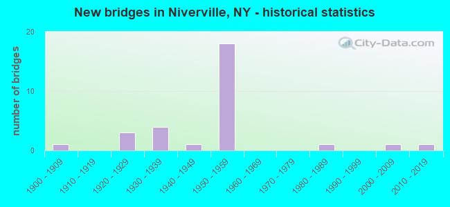
- New bridges - historical statistics
- 11900-1909
- 31920-1929
- 41930-1939
- 11940-1949
- 181950-1959
- 11980-1989
- 12000-2009
- 12010-2019

- Reconstructed bridges - Historical Statistics
- 11970-1979
- 11980-1989
- 21990-1999


- Bridge Condition - Deck
- 5.0%Very good
- 10.0%Good
- 30.0%Satisfactory
- 45.0%Fair
- 10.0%Poor

- Bridge Condition - Superstructure
- 5.0%Excellent
- 5.0%Very good
- 30.0%Good
- 35.0%Satisfactory
- 20.0%Fair
- 5.0%Poor

- Bridge Condition - Substructure
- 5.0%Excellent
- 10.0%Good
- 40.0%Satisfactory
- 40.0%Fair
- 5.0%Poor

- Bridge Condition - Channel
- 9.1%Very good
- 18.2%Good
- 45.5%Satisfactory
- 27.3%Fair
Find on map >> Show street view
Structure Number: 102904, Location: 3.8 MI S JCT RTE66+I90 (Lat: 42.418356, Lng: -73.614369), Route carried "on" structure: State highway 66, Year Built: 1927, Year Reconstructed: 1984, Status: Open, Structure Length: 3.81m (12.50ft), Average Daily Traffic: 1,881 (year 2020), Truck Traffic: 7%, Average Future Daily Traffic: 1,962 (year 2040), Design Load: HS 20, Features Intersected: KINDERHOOK CREEK
Minimum Vertical Clearance: 4.47m (14.67ft), Kilometerpoint: 27.015, Lanes on structure: 2, Base Highway Network: Yes, Owner: State Highway Agency, Approaching Roadway Width: 7.0m (23.0ft), Material/Design: Steel, Design/Construction: Truss - Thru, Number Of Spans In Main Unit: 1, Length of Maximum Span: 36.5m (119.8ft), Curb or Sidewalk Widths: Left: 1.7m (5.6ft), Right: 0.0m, Curb-To-Curb Width: 6.7m (22.0ft), Out-to-Out Width: 9.6m (31.5ft)
Condition: Deck: Satisfactory, Superstructure: Poor, Substructure: Satisfactory, Channel: Fair, Operating Rating: 42.1 metric tons, Method Used To Determine Operating Rating: Load and Resistance Factor Rating (LRFR) rating reported by rating factor(RF) method using HL-93 loadings, Inventory Rating: 32.4 metric tons, Method Used To Determine Inventory Rating: Load and Resistance Factor Rating (LRFR) rating reported by rating factor(RF) method using HL-93 loadings, Structural Evaluation: Meets minimum limits, Deck Geometry: High priority of corrective action, Waterway Adequacy: Meets minimum limits, Approach Roadway Alignment: Equal to present desirable criteria, Length Of Structure Improvement: 3.81m (12.50ft), Designated Inspection Frequency: Every 24 months, Critical Feature Inspection Frequency: Every 24 months, Inspection Date: July 2020, Critical Feature Inspection Date: July 2020, Bridge Improvement Cost: $3,672,000, Roadway Improvement Cost: $2,150,000, Total Project Cost: $5,823,000 ( Estimate for 2021), Deck Structure Type: Concrete Cast-file-Place, Wearing Surface/Protective System: Wearing Surface: Integral Concrete, Deck Protection: Epoxy Coated Reinforcing
Find on map >> Show street view
Structure Number: 102905, Location: JCT S.H.66 & I90 (Lat: 42.461917, Lng: -73.591439), Route carried "on" structure: State highway 66, Year Built: 1958, Status: Open, Structure Length: 8.08m (26.51ft), Average Daily Traffic: 365 (year 2018), Truck Traffic: 7%, Average Future Daily Traffic: 380 (year 2040), Design Load: HS 20, Features Intersected: 90IX WB, RTE I90
Minimum Vertical Clearance: 30+ m (98+ ft), Kilometerpoint: 33.049, Lanes on structure: 2, Lanes under structure: 4, Base Highway Network: Yes, Owner: State Toll Authority, Approaching Roadway Width: 8.5m (27.9ft), Skew: 1 degrees, Material/Design: Steel, Design/Construction: Stringer/Multi-beam, Number Of Spans In Main Unit: 5, Length of Maximum Span: 18.0m (59.1ft), Curb-To-Curb Width: 8.5m (27.9ft), Out-to-Out Width: 10.7m (35.1ft)
Condition: Deck: Satisfactory, Superstructure: Good, Substructure: Fair, Operating Rating: 60.9 metric tons, Method Used To Determine Operating Rating: Load and Resistance Factor Rating (LRFR) rating reported by rating factor(RF) method using HL-93 loadings, Inventory Rating: 46.7 metric tons, Method Used To Determine Inventory Rating: Load and Resistance Factor Rating (LRFR) rating reported by rating factor(RF) method using HL-93 loadings, Structural Evaluation: Somewhat better than minimum adequacy, Deck Geometry: Equal to present minimum criteria, Underclear: High priority of corrective action, Approach Roadway Alignment: Equal to present desirable criteria, Length Of Structure Improvement: 8.07m (26.48ft), Designated Inspection Frequency: Every 24 months, Inspection Date: August 2021, Bridge Improvement Cost: $3,186,000, Roadway Improvement Cost: $1,866,000, Total Project Cost: $5,052,000 ( Estimate for 2021), Deck Structure Type: Concrete Cast-file-Place, Wearing Surface/Protective System: Wearing Surface: Bituminous
Find on map >> Show street view
Structure Number: 104023, Location: 1.9 MI S JCT RTS203+I90 (Lat: 42.461544, Lng: -73.643153), Route carried "on" structure: State highway 203, Year Built: 1939, Year Reconstructed: 1994, Status: Open, Structure Length: 2.23m (7.32ft), Average Daily Traffic: 1,568 (year 2016), Truck Traffic: 4%, Average Future Daily Traffic: 1,635 (year 2040), Design Load: HS 25 or greater, Features Intersected: VALATIE KILL
Minimum Vertical Clearance: 30+ m (98+ ft), Kilometerpoint: 29.686, Lanes on structure: 2, Base Highway Network: Yes, Owner: State Highway Agency, Approaching Roadway Width: 9.8m (32.2ft), Skew: 1 degrees, Material/Design: Steel, Design/Construction: Stringer/Multi-beam, Number Of Spans In Main Unit: 1, Length of Maximum Span: 21.3m (69.9ft), Curb-To-Curb Width: 9.8m (32.2ft), Out-to-Out Width: 10.4m (34.1ft)
Condition: Deck: Satisfactory, Superstructure: Good, Substructure: Good, Channel: Satisfactory, Operating Rating: 79.8 metric tons, Method Used To Determine Operating Rating: Load Factor (LF), Inventory Rating: 47.2 metric tons, Method Used To Determine Inventory Rating: Load Factor (LF), Structural Evaluation: Better than present minimum criteria, Deck Geometry: Somewhat better than minimum adequacy, Waterway Adequacy: Meets minimum limits, Approach Roadway Alignment: Meets minimum limits, Length Of Structure Improvement: 2.22m (7.28ft), Designated Inspection Frequency: Every 24 months, Inspection Date: July 2021, Bridge Improvement Cost: $1,258,000, Roadway Improvement Cost: $736,000, Total Project Cost: $1,994,000 ( Estimate for 2021), Deck Structure Type: Concrete Cast-file-Place, Wearing Surface/Protective System: Wearing Surface: Integral Concrete, Deck Protection: Epoxy Coated Reinforcing
Find on map >> Show street view
Structure Number: 104024, Location: 0.5MI.S JCT.RTS203+I90 (Lat: 42.475417, Lng: -73.631764), Route carried "on" structure: State highway 203, Year Built: 1984, Status: Open, Structure Length: 2.04m (6.69ft), Average Daily Traffic: 1,568 (year 2016), Truck Traffic: 4%, Average Future Daily Traffic: 1,635 (year 2040), Design Load: HS 20, Features Intersected: VALATIE KILL
Minimum Vertical Clearance: 30+ m (98+ ft), Kilometerpoint: 31.778, Lanes on structure: 2, Base Highway Network: Yes, Owner: State Highway Agency, Approaching Roadway Width: 9.1m (29.9ft), Material/Design: Prestressed concrete, Design/Construction: Box Beam or Girders - Multiple, Number Of Spans In Main Unit: 1, Length of Maximum Span: 19.2m (63.0ft), Curb-To-Curb Width: 9.1m (29.9ft), Out-to-Out Width: 10.1m (33.1ft)
Condition: Deck: Satisfactory, Superstructure: Satisfactory, Substructure: Satisfactory, Channel: Satisfactory, Operating Rating: 41.1 metric tons, Method Used To Determine Operating Rating: Load and Resistance Factor Rating (LRFR) rating reported by rating factor(RF) method using HL-93 loadings, Inventory Rating: 31.8 metric tons, Method Used To Determine Inventory Rating: Load and Resistance Factor Rating (LRFR) rating reported by rating factor(RF) method using HL-93 loadings, Structural Evaluation: Equal to present minimum criteria, Deck Geometry: Somewhat better than minimum adequacy, Waterway Adequacy: Somewhat better than minimum adequacy, Approach Roadway Alignment: Equal to present minimum criteria, Length Of Structure Improvement: 2.04m (6.69ft), Designated Inspection Frequency: Every 24 months, Inspection Date: April 2020, Bridge Improvement Cost: $522,000, Roadway Improvement Cost: $306,000, Total Project Cost: $827,000 ( Estimate for 2021), Wearing Surface/Protective System: Wearing Surface: Monolithic Concrete
Find on map >> Show street view
Structure Number: 222216, Location: .6 MI S OF CHATHAM CENTER (Lat: 42.409631, Lng: -73.616617), Route carried "on" structure: Other road , Year Built: 2014, Status: Open, Structure Length: 2.35m (7.71ft), Average Daily Traffic: 298 (year 2019), Truck Traffic: 8%, Average Future Daily Traffic: 417 (year 2039), Design Load: HL 93, Features Intersected: CSX TRANS/ AMTRAK, Facility Carried by Structure: WHITE MILLS ROAD
Minimum Vertical Clearance: 30+ m (98+ ft), Kilometerpoint: 0.869, Lanes on structure: 2, Owner: Railroad, Maintenance Responsibility: Town or Township Highway Agency, Approaching Roadway Width: 8.8m (28.9ft), Material/Design: Prestressed concrete, Design/Construction: Box Beam or Girders - Multiple, Number Of Spans In Main Unit: 1, Length of Maximum Span: 21.5m (70.5ft), Curb-To-Curb Width: 8.9m (29.2ft), Out-to-Out Width: 10.2m (33.5ft)
Condition: Deck: Very good, Superstructure: Excellent, Substructure: Excellent, Operating Rating: 60.9 metric tons, Method Used To Determine Operating Rating: Load and Resistance Factor Rating (LRFR) rating reported by rating factor(RF) method using HL-93 loadings, Inventory Rating: 47.0 metric tons, Method Used To Determine Inventory Rating: Load and Resistance Factor Rating (LRFR) rating reported by rating factor(RF) method using HL-93 loadings, Structural Evaluation: Superior to present desirable criteria, Deck Geometry: Equal to present minimum criteria, Underclear: Meets minimum limits, Approach Roadway Alignment: Somewhat better than minimum adequacy, Length Of Structure Improvement: 2.34m (7.68ft), Designated Inspection Frequency: Every 24 months, Inspection Date: April 2020, Bridge Improvement Cost: $1,080,000, Roadway Improvement Cost: $632,000, Total Project Cost: $1,712,000 ( Estimate for 2021), Deck Structure Type: Concrete Cast-file-Place, Wearing Surface/Protective System: Wearing Surface: Integral Concrete, Deck Protection: Epoxy Coated Reinforcing
Find on map >> Show street view
Structure Number: 222218, Location: 2 MILES EAST OF VALATIE (Lat: 42.420528, Lng: -73.633753), Route carried "on" structure: Other road , Year Built: 1930, Status: Open, Structure Length: 1.71m (5.61ft), Average Daily Traffic: 106 (year 2015), Truck Traffic: 8%, Average Future Daily Traffic: 148 (year 2035), Features Intersected: CSX TRANS/ AMTRAK, Facility Carried by Structure: GOOLD ROAD
Minimum Vertical Clearance: 30+ m (98+ ft), Kilometerpoint: 0.048, Lanes on structure: 2, Owner: Railroad, Maintenance Responsibility: Town or Township Highway Agency, Approaching Roadway Width: 6.1m (20.0ft), Material/Design: Steel, Design/Construction: Girder and Floorbeam System, Number Of Spans In Main Unit: 1, Length of Maximum Span: 15.8m (51.8ft), Curb-To-Curb Width: 6.1m (20.0ft), Out-to-Out Width: 7.0m (23.0ft)
Condition: Deck: Satisfactory, Superstructure: Satisfactory, Substructure: Fair, Operating Rating: 56.3 metric tons, Method Used To Determine Operating Rating: Field evaluation and documented engineering judgment, Inventory Rating: 22.9 metric tons, Method Used To Determine Inventory Rating: Field evaluation and documented engineering judgment, Structural Evaluation: Somewhat better than minimum adequacy, Deck Geometry: Meets minimum limits, Underclear: High priority of corrective action, Approach Roadway Alignment: Meets minimum limits, Length Of Structure Improvement: 1.70m (5.58ft), Designated Inspection Frequency: Every 24 months, Critical Feature Inspection Frequency: Every 24 months, Inspection Date: July 2021, Critical Feature Inspection Date: July 2021, Bridge Improvement Cost: $689,000, Roadway Improvement Cost: $404,000, Total Project Cost: $1,093,000 ( Estimate for 2021), Deck Structure Type: Concrete Cast-file-Place, Wearing Surface/Protective System: Wearing Surface: Bituminous
Find on map >> Show street view
Structure Number: 32221, Location: 1.8 MI S OF MALDEN BRIDGE (Lat: 42.443947, Lng: -73.584306), Route carried "on" structure: Other road , Year Built: 1941, Status: Posted for load, Structure Length: 1.01m (3.31ft), Average Daily Traffic: 169 (year 2020), Truck Traffic: 8%, Average Future Daily Traffic: 237 (year 2040), Design Load: H 20, Features Intersected: TRIBUTARY KINDERHOOK CRE, Facility Carried by Structure: SHAKER MUSEUM ROAD
Minimum Vertical Clearance: 30+ m (98+ ft), Kilometerpoint: 1.432, Lanes on structure: 2, Owner: County Highway Agency, Approaching Roadway Width: 6.1m (20.0ft), Material/Design: Steel, Design/Construction: Stringer/Multi-beam, Number Of Spans In Main Unit: 1, Length of Maximum Span: 9.7m (31.8ft), Curb-To-Curb Width: 6.7m (22.0ft), Out-to-Out Width: 7.5m (24.6ft)
Condition: Deck: Good, Superstructure: Good, Substructure: Satisfactory, Channel: Fair, Operating Rating: 17.2 metric tons, Method Used To Determine Operating Rating: Load and Resistance Factor Rating (LRFR) rating reported by rating factor(RF) method using HL-93 loadings, Inventory Rating: 13.3 metric tons, Method Used To Determine Inventory Rating: Load and Resistance Factor Rating (LRFR) rating reported by rating factor(RF) method using HL-93 loadings, Structural Evaluation: Meets minimum limits, Deck Geometry: Meets minimum limits, Waterway Adequacy: Meets minimum limits, Approach Roadway Alignment: Somewhat better than minimum adequacy, Bridge Posting: Required (Relationship of Operating Rating to Maximum Legal Load: > 39.9% below), Length Of Structure Improvement: 1.00m (3.28ft), Designated Inspection Frequency: Every 12 months, Inspection Date: August 2021, Bridge Improvement Cost: $586,000, Roadway Improvement Cost: $343,000, Total Project Cost: $929,000 ( Estimate for 2021), Deck Structure Type: Concrete Cast-file-Place, Wearing Surface/Protective System: Wearing Surface: Bituminous
Find on map >> Show street view
Structure Number: 33422, Location: 2.8 MI NW OF EAST CHATHAM (Lat: 42.439742, Lng: -73.564467), Route carried "on" structure: County highway , Year Built: 1932, Status: Open, Structure Length: 1.31m (4.30ft), Average Daily Traffic: 711 (year 2020), Truck Traffic: 10%, Average Future Daily Traffic: 995 (year 2040), Features Intersected: SHAKER STREAM, Facility Carried by Structure: COUNTY ROAD 13
Minimum Vertical Clearance: 30+ m (98+ ft), Kilometerpoint: 5.358, Lanes on structure: 2, Owner: County Highway Agency, Approaching Roadway Width: 6.1m (20.0ft), Skew: 4 degrees, Material/Design: Steel, Design/Construction: Stringer/Multi-beam, Number Of Spans In Main Unit: 1, Length of Maximum Span: 11.8m (38.7ft), Curb-To-Curb Width: 6.9m (22.6ft), Out-to-Out Width: 7.7m (25.3ft)
Condition: Deck: Fair, Superstructure: Satisfactory, Substructure: Satisfactory, Channel: Fair, Operating Rating: 53.5 metric tons, Method Used To Determine Operating Rating: Load and Resistance Factor Rating (LRFR) rating reported by rating factor(RF) method using HL-93 loadings, Inventory Rating: 41.1 metric tons, Method Used To Determine Inventory Rating: Load and Resistance Factor Rating (LRFR) rating reported by rating factor(RF) method using HL-93 loadings, Structural Evaluation: Equal to present minimum criteria, Deck Geometry: Meets minimum limits, Waterway Adequacy: Meets minimum limits, Approach Roadway Alignment: Better than present minimum criteria, Length Of Structure Improvement: 1.31m (4.30ft), Designated Inspection Frequency: Every 24 months, Inspection Date: August 2021, Bridge Improvement Cost: $807,000, Roadway Improvement Cost: $472,000, Total Project Cost: $1,279,000 ( Estimate for 2021), Deck Structure Type: Concrete Cast-file-Place, Wearing Surface/Protective System: Wearing Surface: Bituminous
Find on map >> Show street view
Structure Number: 334222, Location: 1.8 MI S OF N CHATHAM (Lat: 42.464372, Lng: -73.632586), Route carried "on" structure: County highway , Year Built: 1935, Status: Open, Structure Length: 1.52m (4.99ft), Average Daily Traffic: 1,247 (year 2020), Truck Traffic: 9%, Average Future Daily Traffic: 1,300 (year 2040), Features Intersected: VALATIE KILL, Facility Carried by Structure: COUNTY ROAD 17
Minimum Vertical Clearance: 30+ m (98+ ft), Kilometerpoint: 4.714, Lanes on structure: 2, Owner: County Highway Agency, Approaching Roadway Width: 6.1m (20.0ft), Skew: 3 degrees, Material/Design: Steel, Design/Construction: Stringer/Multi-beam, Number Of Spans In Main Unit: 1, Length of Maximum Span: 14.6m (47.9ft), Curb-To-Curb Width: 6.5m (21.3ft), Out-to-Out Width: 7.3m (24.0ft)
Condition: Deck: Fair, Superstructure: Fair, Substructure: Fair, Channel: Satisfactory, Operating Rating: 59.0 metric tons, Method Used To Determine Operating Rating: Load Factor (LF), Inventory Rating: 34.5 metric tons, Method Used To Determine Inventory Rating: Load Factor (LF), Structural Evaluation: Somewhat better than minimum adequacy, Deck Geometry: High priority of replacement, Waterway Adequacy: Meets minimum limits, Approach Roadway Alignment: Somewhat better than minimum adequacy, Length Of Structure Improvement: 1.52m (4.99ft), Designated Inspection Frequency: Every 24 months, Inspection Date: April 2021, Bridge Improvement Cost: $784,000, Roadway Improvement Cost: $459,000, Total Project Cost: $1,244,000 ( Estimate for 2021), Deck Structure Type: Concrete Cast-file-Place, Wearing Surface/Protective System: Wearing Surface: Bituminous
Find on map >> Show street view
Structure Number: 334224, Location: 2.1 MI N OF VALATIE (Lat: 42.443208, Lng: -73.664858), Route carried "on" structure: County highway , Year Built: 2004, Status: Open, Structure Length: 2.11m (6.92ft), Average Daily Traffic: 2,338 (year 2020), Truck Traffic: 7%, Average Future Daily Traffic: 2,892 (year 2040), Features Intersected: VALATIE KILL, Facility Carried by Structure: COUNTY ROAD 28
Minimum Vertical Clearance: 30+ m (98+ ft), Kilometerpoint: 2.977, Lanes on structure: 2, Owner: County Highway Agency, Approaching Roadway Width: 8.5m (27.9ft), Material/Design: Prestressed concrete, Design/Construction: Box Beam or Girders - Multiple, Number Of Spans In Main Unit: 1, Length of Maximum Span: 20.0m (65.6ft), Curb or Sidewalk Widths: Left: 1.6m (5.2ft), Right: 0.0m, Curb-To-Curb Width: 8.4m (27.6ft), Out-to-Out Width: 11.3m (37.1ft)
Condition: Deck: Good, Superstructure: Good, Substructure: Good, Channel: Satisfactory, Operating Rating: 84.4 metric tons, Method Used To Determine Operating Rating: Load Factor (LF), Inventory Rating: 50.8 metric tons, Method Used To Determine Inventory Rating: Load Factor (LF), Structural Evaluation: Better than present minimum criteria, Deck Geometry: High priority of corrective action, Waterway Adequacy: Superior to present desirable criteria, Approach Roadway Alignment: Equal to present minimum criteria, Length Of Structure Improvement: 2.11m (6.92ft), Designated Inspection Frequency: Every 24 months, Inspection Date: November 2020, Bridge Improvement Cost: $782,000, Roadway Improvement Cost: $458,000, Total Project Cost: $1,240,000 ( Estimate for 2021), Deck Structure Type: Concrete Cast-file-Place, Wearing Surface/Protective System: Wearing Surface: Integral Concrete, Deck Protection: Epoxy Coated Reinforcing
Find on map >> Show street view
Structure Number: 5040251, Location: JCT RTS 203 & 90 (Lat: 42.480728, Lng: -73.625033), Route carried "on" structure: Interstate 90, Year Built: 1957, Status: Open, Structure Length: 3.41m (11.19ft), Average Daily Traffic: 12,236 (year 2014), Truck Traffic: 26%, Design Load: H 20, Features Intersected: RTE 203
Minimum Vertical Clearance: 30+ m (98+ ft), Kilometerpoint: 14.368, Lanes on structure: 2, Lanes under structure: 2, Base Highway Network: Yes, Toll: On toll road, Owner: State Toll Authority, Approaching Roadway Width: 12.8m (42.0ft), Material/Design: Steel, Design/Construction: Stringer/Multi-beam, Number Of Spans In Main Unit: 3, Length of Maximum Span: 13.4m (44.0ft), Curb-To-Curb Width: 12.3m (40.4ft), Out-to-Out Width: 13.5m (44.3ft)
Condition: Deck: Poor, Superstructure: Satisfactory, Substructure: Fair, Operating Rating: 41.1 metric tons, Method Used To Determine Operating Rating: Load and Resistance Factor Rating (LRFR) rating reported by rating factor(RF) method using HL-93 loadings, Inventory Rating: 31.8 metric tons, Method Used To Determine Inventory Rating: Load and Resistance Factor Rating (LRFR) rating reported by rating factor(RF) method using HL-93 loadings, Structural Evaluation: Somewhat better than minimum adequacy, Deck Geometry: Better than present minimum criteria, Underclear: Meets minimum limits, Approach Roadway Alignment: Better than present minimum criteria, Length Of Structure Improvement: 3.41m (11.19ft), Designated Inspection Frequency: Every 24 months, Inspection Date: August 2020, Bridge Improvement Cost: $1,003,000, Roadway Improvement Cost: $588,000, Total Project Cost: $1,591,000 ( Estimate for 2021), Deck Structure Type: Concrete Cast-file-Place, Wearing Surface/Protective System: Wearing Surface: Bituminous
Find on map >> Show street view
Structure Number: 5040252, Location: JCT RTS 203 & 90 (Lat: 42.480256, Lng: -73.625381), Route carried "on" structure: Interstate 90, Year Built: 1957, Status: Open, Structure Length: 3.41m (11.19ft), Average Daily Traffic: 9,146 (year 2020), Truck Traffic: 38%, Average Future Daily Traffic: 10,893 (year 2040), Design Load: H 20, Features Intersected: RTE 203
Minimum Vertical Clearance: 30+ m (98+ ft), Kilometerpoint: 26.677, Lanes on structure: 2, Lanes under structure: 2, Base Highway Network: Yes, Toll: On toll road, Owner: State Toll Authority, Approaching Roadway Width: 11.9m (39.0ft), Material/Design: Steel, Design/Construction: Stringer/Multi-beam, Number Of Spans In Main Unit: 3, Length of Maximum Span: 13.4m (44.0ft), Curb-To-Curb Width: 12.3m (40.4ft), Out-to-Out Width: 13.5m (44.3ft)
Condition: Deck: Poor, Superstructure: Fair, Substructure: Fair, Operating Rating: 42.4 metric tons, Method Used To Determine Operating Rating: Load and Resistance Factor Rating (LRFR) rating reported by rating factor(RF) method using HL-93 loadings, Inventory Rating: 32.7 metric tons, Method Used To Determine Inventory Rating: Load and Resistance Factor Rating (LRFR) rating reported by rating factor(RF) method using HL-93 loadings, Structural Evaluation: Somewhat better than minimum adequacy, Deck Geometry: Better than present minimum criteria, Underclear: High priority of corrective action, Approach Roadway Alignment: Better than present minimum criteria, Length Of Structure Improvement: 3.41m (11.19ft), Designated Inspection Frequency: Every 24 months, Inspection Date: August 2020, Bridge Improvement Cost: $1,003,000, Roadway Improvement Cost: $588,000, Total Project Cost: $1,591,000 ( Estimate for 2021), Deck Structure Type: Concrete Cast-file-Place, Wearing Surface/Protective System: Wearing Surface: Bituminous
Find on map >> Show street view
Structure Number: 5513451, Location: 0.4 MI NW INT RTS 90I<203 (Lat: 42.482114, Lng: -73.630872), Route carried "on" structure: Interstate 90, Year Built: 1957, Year Reconstructed: 2002, Status: Open, Structure Length: 2.47m (8.10ft), Average Daily Traffic: 9,146 (year 2020), Truck Traffic: 38%, Average Future Daily Traffic: 10,893 (year 2040), Design Load: HS 20+Mod, Features Intersected: VALATIE KILL
Minimum Vertical Clearance: 30+ m (98+ ft), Kilometerpoint: 26.178, Lanes on structure: 2, Base Highway Network: Yes, Toll: On Interstate toll segment, Owner: State Toll Authority, Approaching Roadway Width: 11.6m (38.1ft), Material/Design: Steel, Design/Construction: Stringer/Multi-beam, Number Of Spans In Main Unit: 1, Length of Maximum Span: 23.5m (77.1ft), Curb or Sidewalk Widths: Left: 0.3m (1.0ft), Right: 0.3m (1.0ft), Curb-To-Curb Width: 12.6m (41.3ft), Out-to-Out Width: 13.5m (44.3ft)
Condition: Deck: Fair, Superstructure: Very good, Substructure: Satisfactory, Channel: Good, Operating Rating: 56.4 metric tons, Method Used To Determine Operating Rating: Load and Resistance Factor Rating (LRFR) rating reported by rating factor(RF) method using HL-93 loadings, Inventory Rating: 43.4 metric tons, Method Used To Determine Inventory Rating: Load and Resistance Factor Rating (LRFR) rating reported by rating factor(RF) method using HL-93 loadings, Structural Evaluation: Equal to present minimum criteria, Deck Geometry: Better than present minimum criteria, Waterway Adequacy: Equal to present minimum criteria, Approach Roadway Alignment: Equal to present desirable criteria, Length Of Structure Improvement: 2.46m (8.07ft), Designated Inspection Frequency: Every 24 months, Inspection Date: July 2021, Bridge Improvement Cost: $1,105,000, Roadway Improvement Cost: $647,000, Total Project Cost: $1,752,000 ( Estimate for 2021), Deck Structure Type: Concrete Cast-file-Place, Wearing Surface/Protective System: Wearing Surface: Bituminous, Membrane: Other
Find on map >> Show street view
Structure Number: 5513452, Location: 0.4 MI NW JCT RTS 90I<203 (Lat: 42.482603, Lng: -73.630603), Route carried "on" structure: Interstate 90, Year Built: 1957, Year Reconstructed: 2002, Status: Open, Structure Length: 2.47m (8.10ft), Average Daily Traffic: 12,236 (year 2014), Truck Traffic: 26%, Design Load: HS 20+Mod, Features Intersected: VALATIE KILL
Minimum Vertical Clearance: 30+ m (98+ ft), Kilometerpoint: 13.870, Lanes on structure: 2, Base Highway Network: Yes, Toll: On Interstate toll segment, Owner: State Toll Authority, Approaching Roadway Width: 13.4m (44.0ft), Material/Design: Steel, Design/Construction: Stringer/Multi-beam, Number Of Spans In Main Unit: 1, Length of Maximum Span: 23.5m (77.1ft), Curb or Sidewalk Widths: Left: 0.3m (1.0ft), Right: 0.3m (1.0ft), Curb-To-Curb Width: 12.6m (41.3ft), Out-to-Out Width: 13.5m (44.3ft)
Condition: Deck: Fair, Superstructure: Good, Substructure: Satisfactory, Channel: Satisfactory, Operating Rating: 56.4 metric tons, Method Used To Determine Operating Rating: Load and Resistance Factor Rating (LRFR) rating reported by rating factor(RF) method using HL-93 loadings, Inventory Rating: 43.4 metric tons, Method Used To Determine Inventory Rating: Load and Resistance Factor Rating (LRFR) rating reported by rating factor(RF) method using HL-93 loadings, Structural Evaluation: Equal to present minimum criteria, Deck Geometry: Better than present minimum criteria, Waterway Adequacy: High priority of corrective action, Approach Roadway Alignment: Equal to present desirable criteria, Length Of Structure Improvement: 2.46m (8.07ft), Designated Inspection Frequency: Every 24 months, Inspection Date: July 2021, Bridge Improvement Cost: $1,105,000, Roadway Improvement Cost: $647,000, Total Project Cost: $1,752,000 ( Estimate for 2021), Deck Structure Type: Concrete Cast-file-Place, Wearing Surface/Protective System: Wearing Surface: Bituminous, Membrane: Other
Find on map >> Show street view
Structure Number: 5515211, Location: 1.7 MI W OF MALDEN BRIDGE (Lat: 42.475192, Lng: -73.615686), Route carried "on" structure: Interstate 90, Year Built: 1958, Status: Open, Structure Length: 6.19m (20.31ft), Average Daily Traffic: 12,236 (year 2014), Truck Traffic: 20%, Design Load: HS 20+Mod, Features Intersected: COUNTY ROAD 32
Minimum Vertical Clearance: 30+ m (98+ ft), Kilometerpoint: 15.302, Lanes on structure: 2, Lanes under structure: 2, Base Highway Network: Yes, Toll: On toll road, Owner: State Toll Authority, Approaching Roadway Width: 11.6m (38.1ft), Skew: 4 degrees, Material/Design: Steel, Design/Construction: Stringer/Multi-beam, Number Of Spans In Main Unit: 3, Length of Maximum Span: 24.4m (80.1ft), Curb or Sidewalk Widths: Left: 0.9m (3.0ft), Right: 0.9m (3.0ft), Curb-To-Curb Width: 11.3m (37.1ft), Out-to-Out Width: 13.7m (44.9ft)
Condition: Deck: Fair, Superstructure: Fair, Substructure: Poor, Operating Rating: 66.2 metric tons, Method Used To Determine Operating Rating: Load Factor (LF), Inventory Rating: 39.0 metric tons, Method Used To Determine Inventory Rating: Load Factor (LF), Structural Evaluation: Meets minimum limits, Deck Geometry: Somewhat better than minimum adequacy, Underclear: Somewhat better than minimum adequacy, Approach Roadway Alignment: Equal to present desirable criteria, Length Of Structure Improvement: 6.18m (20.28ft), Designated Inspection Frequency: Every 24 months, Inspection Date: May 2021, Bridge Improvement Cost: $3,994,000, Roadway Improvement Cost: $2,339,000, Total Project Cost: $6,333,000 ( Estimate for 2021), Deck Structure Type: Concrete Cast-file-Place, Wearing Surface/Protective System: Wearing Surface: Bituminous
Find on map >> Show street view
Structure Number: 5515212, Location: 1.7 MI W OF MALDEN BRIDGE (Lat: 42.475258, Lng: -73.616500), Route carried "on" structure: Interstate 90, Year Built: 1958, Status: Open, Structure Length: 6.34m (20.80ft), Average Daily Traffic: 9,162 (year 2020), Truck Traffic: 38%, Average Future Daily Traffic: 16,061 (year 2040), Design Load: HS 20+Mod, Features Intersected: COUNTY ROAD 32
Minimum Vertical Clearance: 30+ m (98+ ft), Kilometerpoint: 0.869, Lanes on structure: 2, Lanes under structure: 2, Base Highway Network: Yes, Toll: On toll road, Owner: State Toll Authority, Approaching Roadway Width: 11.6m (38.1ft), Skew: 5 degrees, Material/Design: Steel, Design/Construction: Stringer/Multi-beam, Number Of Spans In Main Unit: 3, Length of Maximum Span: 23.2m (76.1ft), Curb or Sidewalk Widths: Left: 0.9m (3.0ft), Right: 0.9m (3.0ft), Curb-To-Curb Width: 11.3m (37.1ft), Out-to-Out Width: 13.7m (44.9ft)
Condition: Deck: Fair, Superstructure: Fair, Substructure: Fair, Operating Rating: 76.2 metric tons, Method Used To Determine Operating Rating: Load Factor (LF), Inventory Rating: 45.4 metric tons, Method Used To Determine Inventory Rating: Load Factor (LF), Structural Evaluation: Somewhat better than minimum adequacy, Deck Geometry: Somewhat better than minimum adequacy, Underclear: Somewhat better than minimum adequacy, Approach Roadway Alignment: Equal to present desirable criteria, Length Of Structure Improvement: 6.33m (20.77ft), Designated Inspection Frequency: Every 24 months, Inspection Date: May 2021, Bridge Improvement Cost: $3,950,000, Roadway Improvement Cost: $2,313,000, Total Project Cost: $6,262,000 ( Estimate for 2021), Deck Structure Type: Concrete Cast-file-Place, Wearing Surface/Protective System: Wearing Surface: Bituminous
Find on map >> Show street view
Structure Number: 5515221, Location: 0.7 MI S OF MALDEN BRIDGE (Lat: 42.461775, Lng: -73.588914), Route carried "on" structure: Interstate 90, Year Built: 1958, Status: Open, Structure Length: 7.65m (25.10ft), Average Daily Traffic: 12,236 (year 2014), Truck Traffic: 20%, Design Load: HS 20+Mod, Features Intersected: KINDERHOOK CREEK
Minimum Vertical Clearance: 30+ m (98+ ft), Kilometerpoint: 1305.462, Lanes on structure: 2, Base Highway Network: Yes, Toll: On Interstate toll segment, Owner: State Toll Authority, Approaching Roadway Width: 13.1m (43.0ft), Skew: 1 degrees, Material/Design: Steel, Design/Construction: Stringer/Multi-beam, Number Of Spans In Main Unit: 3, Length of Maximum Span: 24.7m (81.0ft), Curb or Sidewalk Widths: Left: 0.8m (2.6ft), Right: 0.8m (2.6ft), Curb-To-Curb Width: 11.3m (37.1ft), Out-to-Out Width: 13.4m (44.0ft)
Condition: Deck: Fair, Superstructure: Satisfactory, Substructure: Satisfactory, Channel: Very good, Operating Rating: 77.1 metric tons, Method Used To Determine Operating Rating: Load Factor (LF), Inventory Rating: 46.3 metric tons, Method Used To Determine Inventory Rating: Load Factor (LF), Structural Evaluation: Equal to present minimum criteria, Deck Geometry: Somewhat better than minimum adequacy, Waterway Adequacy: Equal to present minimum criteria, Approach Roadway Alignment: Equal to present desirable criteria, Length Of Structure Improvement: 7.65m (25.10ft), Designated Inspection Frequency: Every 24 months, Inspection Date: May 2021, Bridge Improvement Cost: $3,817,000, Roadway Improvement Cost: $2,235,000, Total Project Cost: $6,052,000 ( Estimate for 2021), Deck Structure Type: Concrete Cast-file-Place, Wearing Surface/Protective System: Wearing Surface: Bituminous
Find on map >> Show street view
Structure Number: 5515222, Location: 0.7 MI S OF MALDEN BRIDGE (Lat: 42.461400, Lng: -73.588925), Route carried "on" structure: Interstate 90, Year Built: 1958, Status: Open, Structure Length: 7.65m (25.10ft), Average Daily Traffic: 9,162 (year 2020), Truck Traffic: 38%, Average Future Daily Traffic: 16,061 (year 2040), Design Load: HS 20+Mod, Features Intersected: KINDERHOOK CREEK
Minimum Vertical Clearance: 30+ m (98+ ft), Kilometerpoint: 3.813, Lanes on structure: 2, Base Highway Network: Yes, Toll: On Interstate toll segment, Owner: State Toll Authority, Approaching Roadway Width: 13.1m (43.0ft), Skew: 1 degrees, Material/Design: Steel, Design/Construction: Stringer/Multi-beam, Number Of Spans In Main Unit: 3, Length of Maximum Span: 24.7m (81.0ft), Curb or Sidewalk Widths: Left: 0.8m (2.6ft), Right: 0.8m (2.6ft), Curb-To-Curb Width: 11.2m (36.7ft), Out-to-Out Width: 13.4m (44.0ft)
Condition: Deck: Fair, Superstructure: Satisfactory, Substructure: Satisfactory, Channel: Good, Operating Rating: 77.1 metric tons, Method Used To Determine Operating Rating: Load Factor (LF), Inventory Rating: 46.3 metric tons, Method Used To Determine Inventory Rating: Load Factor (LF), Structural Evaluation: Equal to present minimum criteria, Deck Geometry: Somewhat better than minimum adequacy, Waterway Adequacy: Equal to present minimum criteria, Approach Roadway Alignment: Equal to present desirable criteria, Length Of Structure Improvement: 7.65m (25.10ft), Designated Inspection Frequency: Every 24 months, Inspection Date: May 2021, Bridge Improvement Cost: $3,817,000, Roadway Improvement Cost: $2,235,000, Total Project Cost: $6,052,000 ( Estimate for 2021), Deck Structure Type: Concrete Cast-file-Place, Wearing Surface/Protective System: Wearing Surface: Bituminous
Find on map >> Show street view
Structure Number: 551523, Location: 0.8 MI S OF MALDEN BRIDGE (Lat: 42.458647, Lng: -73.582681), Route carried "on" structure: Other road , Year Built: 1958, Status: Open, Structure Length: 8.02m (26.31ft), Average Daily Traffic: 169 (year 2020), Truck Traffic: 8%, Average Future Daily Traffic: 237 (year 2040), Design Load: H 20, Features Intersected: 90IX WB, RTE I90, Facility Carried by Structure: SHAKER MUSEUM RD
Minimum Vertical Clearance: 30+ m (98+ ft), Kilometerpoint: 3.105, Lanes on structure: 2, Lanes under structure: 4, Owner: State Toll Authority, Approaching Roadway Width: 7.3m (24.0ft), Material/Design: Steel, Design/Construction: Stringer/Multi-beam, Number Of Spans In Main Unit: 5, Length of Maximum Span: 17.7m (58.1ft), Curb or Sidewalk Widths: Left: 0.4m (1.3ft), Right: 0.4m (1.3ft), Curb-To-Curb Width: 7.3m (24.0ft), Out-to-Out Width: 9.4m (30.8ft)
Condition: Deck: Satisfactory, Superstructure: Good, Substructure: Fair, Operating Rating: 68.9 metric tons, Method Used To Determine Operating Rating: Load Factor (LF), Inventory Rating: 40.8 metric tons, Method Used To Determine Inventory Rating: Load Factor (LF), Structural Evaluation: Somewhat better than minimum adequacy, Deck Geometry: Somewhat better than minimum adequacy, Underclear: High priority of corrective action, Approach Roadway Alignment: Better than present minimum criteria, Length Of Structure Improvement: 8.01m (26.28ft), Designated Inspection Frequency: Every 24 months, Inspection Date: April 2021, Bridge Improvement Cost: $2,837,000, Roadway Improvement Cost: $1,661,000, Total Project Cost: $4,498,000 ( Estimate for 2021), Deck Structure Type: Concrete Cast-file-Place, Wearing Surface/Protective System: Wearing Surface: Bituminous, Membrane: Other
Find on map >> Show street view
Structure Number: 551524, Location: 1.8 MI SE OF MALDEN BRIDG (Lat: 42.446433, Lng: -73.567092), Route carried "on" structure: Other road , Year Built: 1958, Status: Open, Structure Length: 14.87m (48.79ft), Average Daily Traffic: 531 (year 2020), Truck Traffic: 8%, Average Future Daily Traffic: 743 (year 2040), Design Load: H 20, Features Intersected: RTE I90, 90IX WB, Facility Carried by Structure: ALBANY TURNPIKE
Minimum Vertical Clearance: 30+ m (98+ ft), Kilometerpoint: 5.712, Lanes on structure: 2, Lanes under structure: 4, Owner: State Toll Authority, Approaching Roadway Width: 6.7m (22.0ft), Skew: 5 degrees, Material/Design: Steel, Design/Construction: Stringer/Multi-beam, Number Of Spans In Main Unit: 5, Length of Maximum Span: 36.9m (121.1ft), Curb or Sidewalk Widths: Left: 0.8m (2.6ft), Right: 0.8m (2.6ft), Curb-To-Curb Width: 7.9m (25.9ft), Out-to-Out Width: 10.1m (33.1ft)
Condition: Deck: Fair, Superstructure: Satisfactory, Substructure: Fair, Operating Rating: 61.7 metric tons, Method Used To Determine Operating Rating: Load Factor (LF), Inventory Rating: 37.2 metric tons, Method Used To Determine Inventory Rating: Load Factor (LF), Structural Evaluation: Somewhat better than minimum adequacy, Deck Geometry: Somewhat better than minimum adequacy, Underclear: Meets minimum limits, Approach Roadway Alignment: Equal to present desirable criteria, Length Of Structure Improvement: 14.87m (48.79ft), Designated Inspection Frequency: Every 24 months, Inspection Date: May 2021, Bridge Improvement Cost: $5,823,000, Roadway Improvement Cost: $3,410,000, Total Project Cost: $9,233,000 ( Estimate for 2021), Deck Structure Type: Concrete Cast-file-Place, Wearing Surface/Protective System: Wearing Surface: Monolithic Concrete
Find on map >> Show street view
Structure Number: 102905, Location: JCT S.H.66 & I90 (Lat: 42.461917, Lng: -73.591439), Route carried "under" structure: Interstate 90, Year Built: 1958, Structure Length: 0. m, Average Daily Traffic: 11,700 (year 1979), Features Intersected: 90IX WB, RTE I90, Facility Carried by Structure: RTE 66
Minimum Vertical Clearance: 4.52m (14.83ft), Kilometerpoint: 18.037, Lanes on structure: 2, Lanes under structure: 2, Toll: On Interstate toll segment, Material/Design: Steel, Design/Construction: Stringer/Multi-beam, Length of Maximum Span: 18.0m (59.1ft)
Find on map >> Show street view
Structure Number: 5040251, Location: JCT RTS 203 & 90 (Lat: 42.480728, Lng: -73.625033), Route carried "under" structure: State highway 203, Year Built: 1957, Structure Length: 0. m, Average Daily Traffic: 1,753 (year 2014), Features Intersected: RTE 203, Facility Carried by Structure: RTE I90
Minimum Vertical Clearance: 4.37m (14.34ft), Kilometerpoint: 2.880, Lanes on structure: 2, Lanes under structure: 2, Material/Design: Steel, Design/Construction: Stringer/Multi-beam, Length of Maximum Span: 13.4m (44.0ft)
Find on map >> Show street view
Structure Number: 5040252, Location: JCT RTS 203 & 90 (Lat: 42.480256, Lng: -73.625381), Route carried "under" structure: State highway 203, Year Built: 1957, Structure Length: 0. m, Average Daily Traffic: 1,753 (year 2014), Features Intersected: RTE 203, Facility Carried by Structure: RTE I90
Minimum Vertical Clearance: 4.42m (14.50ft), Kilometerpoint: 2.880, Lanes on structure: 2, Lanes under structure: 2, Material/Design: Steel, Design/Construction: Stringer/Multi-beam, Length of Maximum Span: 13.4m (44.0ft)
Find on map >> Show street view
Structure Number: 5515211, Location: 1.7 MI W OF MALDEN BRIDGE (Lat: 42.475192, Lng: -73.615686), Route carried "under" structure: County highway , Year Built: 1958, Structure Length: 0. m, Features Intersected: COUNTY ROAD 32, Facility Carried by Structure: RTE I90
Minimum Vertical Clearance: 4.47m (14.67ft), Kilometerpoint: 1.094, Lanes on structure: 2, Lanes under structure: 2, Material/Design: Steel, Design/Construction: Stringer/Multi-beam, Length of Maximum Span: 24.4m (80.1ft)
Find on map >> Show street view
Structure Number: 5515212, Location: 1.7 MI W OF MALDEN BRIDGE (Lat: 42.475258, Lng: -73.616500), Route carried "under" structure: County highway , Year Built: 1958, Structure Length: 0. m, Features Intersected: COUNTY ROAD 32, Facility Carried by Structure: RTE I90
Minimum Vertical Clearance: 4.72m (15.49ft), Kilometerpoint: 0.000, Lanes on structure: 2, Lanes under structure: 2, Toll: On toll road, Material/Design: Steel, Design/Construction: Stringer/Multi-beam, Length of Maximum Span: 23.2m (76.1ft)
Find on map >> Show street view
Structure Number: 551523, Location: 0.8 MI S OF MALDEN BRIDGE (Lat: 42.458647, Lng: -73.582681), Route carried "under" structure: Interstate 90, Year Built: 1958, Structure Length: 0. m, Average Daily Traffic: 11,451 (year 1977), Features Intersected: 90IX WB, RTE I90, Facility Carried by Structure: SHAKER MUSEUM RD
Minimum Vertical Clearance: 4.52m (14.83ft), Kilometerpoint: 18.857, Lanes on structure: 2, Lanes under structure: 2, Toll: On Interstate toll segment, Material/Design: Steel, Design/Construction: Stringer/Multi-beam, Length of Maximum Span: 17.7m (58.1ft)
Find on map >> Show street view
Structure Number: 551524, Location: 1.8 MI SE OF MALDEN BRIDG (Lat: 42.446433, Lng: -73.567092), Route carried "under" structure: Interstate 90, Year Built: 1958, Structure Length: 0. m, Average Daily Traffic: 11,451 (year 1977), Features Intersected: RTE I90, 90IX WB, Facility Carried by Structure: ALBANY TURNPIKE
Minimum Vertical Clearance: 7.01m (23.00ft), Kilometerpoint: 1307.940, Lanes on structure: 2, Lanes under structure: 2, Toll: On toll road, Material/Design: Steel, Design/Construction: Stringer/Multi-beam, Length of Maximum Span: 36.9m (121.1ft)
Find on map >> Show street view
Structure Number: 700546, Location: 0.7MI S JCT RTS 9 & 90I (Lat: 42.471617, Lng: -73.687781), Route carried "under" structure: US 9, Year Built: 1924, Structure Length: 0. m, Average Daily Traffic: 14,098 (year 2000), Features Intersected: RTE 9, Facility Carried by Structure: CSX TRANSPRTATION
Minimum Vertical Clearance: 5.33m (17.49ft), Kilometerpoint: 28.447, Lanes under structure: 2, Material/Design: Concrete, Design/Construction: Frame, Length of Maximum Span: 9.7m (31.8ft)
Find on map >> Show street view
Structure Number: 704022, Location: IN NIVERVILLE (Lat: 42.436517, Lng: -73.653567), Route carried "under" structure: State highway 203, Year Built: 1928, Structure Length: 0. m, Average Daily Traffic: 1,498 (year 2002), Features Intersected: RTE 203, EX-ALB & HDSON, Facility Carried by Structure: CSX TRANSPRTATION
Minimum Vertical Clearance: 4.34m (14.24ft), Kilometerpoint: 26.790, Lanes under structure: 2, Material/Design: Steel, Design/Construction: Girder and Floorbeam System, Length of Maximum Span: 16.4m (53.8ft)
Find on map >> Show street view
Structure Number: 771333, Location: 2.0 MI N OF VALATIE (Lat: 42.440242, Lng: -73.658647), Route carried "under" structure: County highway , Year Built: 1903, Structure Length: 0. m, Features Intersected: PARKER HL RD-CR25, Facility Carried by Structure: CSX TRANSPRTATION
Minimum Vertical Clearance: 3.99m (13.09ft), Kilometerpoint: 0.000, Lanes under structure: 1, Material/Design: Steel, Design/Construction: Girder and Floorbeam System, Length of Maximum Span: 10.0m (32.8ft)