Bridge Statistics for Nokesville, Virginia (VA)
Condition, Traffic, Stress, Structural Evaluation, Project Costs
- National Bridge Inventory (NBI) Statistics
- 23Number of bridges
- 197ft / 60.3mTotal length
- $3,234,000Total costs
- 43,871Total average daily traffic
- 1,894Total average daily truck traffic
- National Bridge Inventory (NBI) Registered Bridges for Nokesville
- No street view available for this location
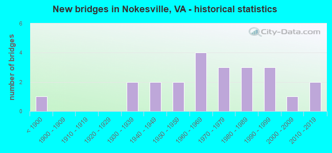
- New bridges - historical statistics
- 1Before 1900
- 21930-1939
- 21940-1949
- 21950-1959
- 41960-1969
- 31970-1979
- 31980-1989
- 31990-1999
- 12000-2009
- 22010-2019

- Reconstructed bridges - Historical Statistics
- 11970-1979
- 11980-1989
- 21990-1999
- 22000-2009
- 22010-2019


- Bridge Condition - Deck
- 5.6%Very good
- 88.9%Good
- 5.6%Satisfactory

- Bridge Condition - Superstructure
- 5.6%Very good
- 72.2%Good
- 16.7%Satisfactory
- 5.6%Fair

- Bridge Condition - Substructure
- 50.0%Good
- 33.3%Satisfactory
- 16.7%Fair

- Bridge Condition - Channel
- 11.8%Very good
- 17.6%Good
- 29.4%Satisfactory
- 41.2%Fair

- Bridge Condition - Culverts
- 25.0%Good
- 50.0%Satisfactory
- 25.0%Fair
Find on map >> Show street view
Structure Number: 2VA00GG, Location: 1.3KM NORTH OF MCB-8 (Lat: 38.623850, Lng: -77.528461), Route carried "on" structure: Other road , Year Built: 1947, Year Reconstructed: 1994, Status: Open, Structure Length: 3.46m (11.35ft), Average Daily Traffic: 500 (year 2015), Truck Traffic: 10%, Average Future Daily Traffic: 600 (year 2039), Features Intersected: CEDAR RUN, Facility Carried by Structure: MCB-1
Minimum Vertical Clearance: 30+ m (98+ ft), Kilometerpoint: 0.000, Lanes on structure: 2, Owner: Navy/Marines, Approaching Roadway Width: 6.3m (20.7ft), Material/Design: Steel, Design/Construction: Stringer/Multi-beam, Number Of Spans In Main Unit: 1, Length of Maximum Span: 34.6m (113.5ft), Curb-To-Curb Width: 7.3m (24.0ft), Out-to-Out Width: 8.1m (26.6ft)
Condition: Deck: Good, Superstructure: Satisfactory, Substructure: Fair, Channel: Fair, Inventory Rating: 63.0 metric tons, Method Used To Determine Inventory Rating: Load Factor (LF), Structural Evaluation: Somewhat better than minimum adequacy, Deck Geometry: Meets minimum limits, Waterway Adequacy: Equal to present desirable criteria, Approach Roadway Alignment: Equal to present desirable criteria, Length Of Structure Improvement: 3.46m (11.35ft), Designated Inspection Frequency: Every 24 months, Inspection Date: September 2021, Bridge Improvement Cost: $143,000, Roadway Improvement Cost: $20,000, Total Project Cost: $162,000 ( Estimate for 2021), Deck Structure Type: Concrete Cast-file-Place
Find on map >> Show street view
Structure Number: 1345, Location: .15-Rt 29 / .00-ECL Amh (Lat: 37.580222, Lng: -79.045700), Route carried "on" structure: US 60, Year Built: 1936, Year Reconstructed: 1978, Status: Open, Structure Length: 3.92m (12.86ft), Average Daily Traffic: 5,256 (year 2020), Truck Traffic: 10%, Average Future Daily Traffic: 7,358 (year 2040), Features Intersected: NS Railway
Minimum Vertical Clearance: 30+ m (98+ ft), Kilometerpoint: 147.378, Lanes on structure: 2, Base Highway Network: Yes, Owner: State Highway Agency, Approaching Roadway Width: 10.4m (34.1ft), Skew: 1 degrees, Material/Design: Steel, Design/Construction: Stringer/Multi-beam, Number Of Spans In Main Unit: 3, Length of Maximum Span: 16.8m (55.1ft), Curb or Sidewalk Widths: Left: 0.3m (1.0ft), Right: 0.3m (1.0ft), Curb-To-Curb Width: 10.4m (34.1ft), Out-to-Out Width: 11.2m (36.7ft)
Condition: Deck: Good, Superstructure: Good, Substructure: Satisfactory, Operating Rating: 59.9 metric tons, Method Used To Determine Operating Rating: Load and Resistance Factor (LRFR), Inventory Rating: 46.3 metric tons, Method Used To Determine Inventory Rating: Load and Resistance Factor (LRFR), Structural Evaluation: Equal to present minimum criteria, Deck Geometry: Meets minimum limits, Underclear: Somewhat better than minimum adequacy, Approach Roadway Alignment: Equal to present minimum criteria, Designated Inspection Frequency: Every 24 months, Inspection Date: October 2021, Deck Structure Type: Concrete Cast-file-Place
Find on map >> Show street view
Structure Number: 4099, Location: 0.50-Rt.658/1.50-Rt.602 (Lat: 37.623361, Lng: -78.570142), Route carried "on" structure: County highway 659, Year Built: 1988, Status: Open, Structure Length: 1.04m (3.41ft), Average Daily Traffic: 83 (year 2018), Average Future Daily Traffic: 92 (year 2040), Design Load: HS 20, Features Intersected: Walton Fork Creek, Facility Carried by Structure: Watoga Road
Minimum Vertical Clearance: 30+ m (98+ ft), Kilometerpoint: 2.404, Lanes on structure: 2, Owner: State Highway Agency, Approaching Roadway Width: 6.1m (20.0ft), Material/Design: Concrete, Design/Construction: Culvert, Number Of Spans In Main Unit: 4, Length of Maximum Span: 2.4m (7.9ft)
Condition: Channel: Fair, Culverts: Satisfactory, Operating Rating: 67.1 metric tons, Method Used To Determine Operating Rating: Load Factor (LF), Inventory Rating: 39.9 metric tons, Method Used To Determine Inventory Rating: Load Factor (LF), Structural Evaluation: Equal to present minimum criteria, Waterway Adequacy: Equal to present desirable criteria, Approach Roadway Alignment: Equal to present desirable criteria, Designated Inspection Frequency: Every 24 months, Inspection Date: May 2021
Find on map >> Show street view
Structure Number: 12962, Location: 1.75 From 20 & .68 To 644 (Lat: 38.234506, Lng: -78.258169), Route carried "on" structure: County highway 609, Year Built: 1960, Status: Open, Structure Length: 1.46m (4.79ft), Average Daily Traffic: 1,184 (year 2020), Truck Traffic: 2%, Average Future Daily Traffic: 1,658 (year 2040), Design Load: HS 20, Features Intersected: Marsh Run, Facility Carried by Structure: Scuffletown Road
Minimum Vertical Clearance: 30+ m (98+ ft), Kilometerpoint: 4.877, Lanes on structure: 2, Owner: State Highway Agency, Approaching Roadway Width: 5.8m (19.0ft), Skew: 3 degrees, Material/Design: Concrete, Design/Construction: Culvert, Number Of Spans In Main Unit: 4, Length of Maximum Span: 3.7m (12.1ft)
Condition: Channel: Fair, Culverts: Satisfactory, Operating Rating: 89.8 metric tons, Method Used To Determine Operating Rating: Load Factor (LF), Inventory Rating: 59.0 metric tons, Method Used To Determine Inventory Rating: Load Factor (LF), Structural Evaluation: Equal to present minimum criteria, Waterway Adequacy: Better than present minimum criteria, Approach Roadway Alignment: Equal to present minimum criteria, Designated Inspection Frequency: Every 24 months, Inspection Date: December 2020
Find on map >> Show street view
Structure Number: 13033, Location: Louisa/Orange Co. Line (Lat: 38.138944, Lng: -78.006800), Route carried "on" structure: County highway 669, Year Built: 1970, Status: Open, Structure Length: 3.38m (11.09ft), Average Daily Traffic: 717 (year 2020), Truck Traffic: 3%, Average Future Daily Traffic: 1,004 (year 2040), Design Load: HS 20+Mod, Features Intersected: North Anna River, Facility Carried by Structure: Marquis Lane
Minimum Vertical Clearance: 30+ m (98+ ft), Kilometerpoint: 0.016, Lanes on structure: 2, Owner: State Highway Agency, Approaching Roadway Width: 5.5m (18.0ft), Skew: 3 degrees, Material/Design: Concrete continuous, Design/Construction: Slab, Number Of Spans In Main Unit: 3, Length of Maximum Span: 12.8m (42.0ft), Curb or Sidewalk Widths: Left: 0.2m (0.7ft), Right: 0.2m (0.7ft), Curb-To-Curb Width: 8.1m (26.6ft), Out-to-Out Width: 9.1m (29.9ft)
Condition: Deck: Good, Superstructure: Good, Substructure: Satisfactory, Channel: Satisfactory, Operating Rating: 55.3 metric tons, Method Used To Determine Operating Rating: Allowable Stress (AS), Inventory Rating: 32.7 metric tons, Method Used To Determine Inventory Rating: Allowable Stress (AS), Structural Evaluation: Equal to present minimum criteria, Deck Geometry: Somewhat better than minimum adequacy, Waterway Adequacy: Equal to present minimum criteria, Approach Roadway Alignment: Equal to present desirable criteria, Designated Inspection Frequency: Every 24 months, Underwater Inspection Frequency: Every 60 months, Inspection Date: November 2021, Underwater Inspection Date: September 2017, Deck Structure Type: Concrete Cast-file-Place
Find on map >> Show street view
Structure Number: 13164, Location: 0.00 WCL LURAY - 0.40 652 (Lat: 38.670583, Lng: -78.473500), Route carried "on" structure: County highway 675, Year Built: 1972, Status: Open, Structure Length: 6.22m (20.41ft), Average Daily Traffic: 1,418 (year 2020), Truck Traffic: 1%, Average Future Daily Traffic: 1,560 (year 2040), Design Load: HS 20+Mod, Features Intersected: ROUTE 211, Facility Carried by Structure: BIXLERS FERRY RD
Minimum Vertical Clearance: 30+ m (98+ ft), Kilometerpoint: 0.000, Lanes on structure: 2, Lanes under structure: 4, Owner: State Highway Agency, Approaching Roadway Width: 6.1m (20.0ft), Skew: 1 degrees, Material/Design: Steel continuous, Design/Construction: Stringer/Multi-beam, Number Of Spans In Main Unit: 2, Length of Maximum Span: 31.1m (102.0ft), Curb or Sidewalk Widths: Left: 0.2m (0.7ft), Right: 1.5m (4.9ft), Curb-To-Curb Width: 9.4m (30.8ft), Out-to-Out Width: 11.8m (38.7ft)
Condition: Deck: Good, Superstructure: Good, Substructure: Satisfactory, Operating Rating: 60.8 metric tons, Method Used To Determine Operating Rating: Load and Resistance Factor (LRFR), Inventory Rating: 47.2 metric tons, Method Used To Determine Inventory Rating: Load and Resistance Factor (LRFR), Structural Evaluation: Equal to present minimum criteria, Deck Geometry: Somewhat better than minimum adequacy, Underclear: Equal to present minimum criteria, Approach Roadway Alignment: Better than present minimum criteria, Designated Inspection Frequency: Every 24 months, Inspection Date: March 2021, Deck Structure Type: Concrete Cast-file-Place, Wearing Surface/Protective System: Wearing Surface: Epoxy Overlay
Find on map >> Show street view
Structure Number: 13275, Location: 0.50-RTE 694;0.05-RTE 798 (Lat: 36.637347, Lng: -80.144522), Route carried "on" structure: County highway 626, Year Built: 1932, Status: Posted for load, Structure Length: 1.40m (4.59ft), Average Daily Traffic: 369 (year 2020), Truck Traffic: 6%, Average Future Daily Traffic: 428 (year 2040), Design Load: HS 20+Mod, Features Intersected: Branch Mill Creek
Minimum Vertical Clearance: 30+ m (98+ ft), Kilometerpoint: 5.197, Lanes on structure: 2, Owner: State Highway Agency, Approaching Roadway Width: 5.5m (18.0ft), Material/Design: Steel, Design/Construction: Stringer/Multi-beam, Number Of Spans In Main Unit: 1, Length of Maximum Span: 14.0m (45.9ft), Curb-To-Curb Width: 7.4m (24.3ft), Out-to-Out Width: 7.9m (25.9ft)
Condition: Deck: Good, Superstructure: Fair, Substructure: Good, Channel: Good, Operating Rating: 36.3 metric tons, Method Used To Determine Operating Rating: Load Factor (LF), Inventory Rating: 21.8 metric tons, Method Used To Determine Inventory Rating: Load Factor (LF), Structural Evaluation: Somewhat better than minimum adequacy, Deck Geometry: Somewhat better than minimum adequacy, Waterway Adequacy: Better than present minimum criteria, Approach Roadway Alignment: Equal to present minimum criteria, Length Of Structure Improvement: 1.37m (4.49ft), Designated Inspection Frequency: Every 24 months, Inspection Date: December 2021, Bridge Improvement Cost: $459,000, Roadway Improvement Cost: $161,000, Total Project Cost: $1,493,000 ( Estimate for 2015), Deck Structure Type: Wood or Timber, Wearing Surface/Protective System: Wearing Surface: Bituminous
Find on map >> Show street view
Structure Number: 13444, Location: 0.23-Rt.29NBL/1.32-Rt.57 (Lat: 36.806678, Lng: -79.392264), Route carried "on" structure: Ramp US 29, Year Built: 1964, Year Reconstructed: 2007, Status: Open, Structure Length: 5.61m (18.41ft), Average Daily Traffic: 2,603 (year 2020), Truck Traffic: 3%, Average Future Daily Traffic: 3,646 (year 2040), Features Intersected: Route 29 Bypass
Minimum Vertical Clearance: 30+ m (98+ ft), Kilometerpoint: 35.099, Lanes on structure: 1, Lanes under structure: 4, Base Highway Network: Yes, Owner: State Highway Agency, Approaching Roadway Width: 7.3m (24.0ft), Skew: 3 degrees, Material/Design: Steel continuous, Design/Construction: Stringer/Multi-beam, Number Of Spans In Main Unit: 4, Length of Maximum Span: 15.1m (49.5ft), Curb-To-Curb Width: 7.6m (24.9ft), Out-to-Out Width: 8.1m (26.6ft)
Condition: Deck: Good, Superstructure: Very good, Substructure: Fair, Operating Rating: 66.2 metric tons, Method Used To Determine Operating Rating: Load Factor (LF), Inventory Rating: 39.9 metric tons, Method Used To Determine Inventory Rating: Load Factor (LF), Structural Evaluation: Somewhat better than minimum adequacy, Deck Geometry: Better than present minimum criteria, Underclear: Meets minimum limits, Approach Roadway Alignment: Equal to present desirable criteria, Designated Inspection Frequency: Every 24 months, Inspection Date: October 2021, Deck Structure Type: Concrete Cast-file-Place, Wearing Surface/Protective System: Deck Protection: Epoxy Coated Reinforcing
Find on map >> Show street view
Structure Number: 13446, Location: 1.02 CHAT CL/0.0 29 BYPS (Lat: 36.848872, Lng: -79.394039), Route carried "on" structure: Business US 29, Year Built: 1964, Year Reconstructed: 2010, Status: Open, Structure Length: 5.80m (19.03ft), Average Daily Traffic: 2,534 (year 2020), Truck Traffic: 3%, Average Future Daily Traffic: 2,787 (year 2040), Design Load: HS 20, Features Intersected: RTE 29 Bypass
Minimum Vertical Clearance: 30+ m (98+ ft), Kilometerpoint: 40.225, Lanes on structure: 2, Lanes under structure: 4, Base Highway Network: Yes, Owner: State Highway Agency, Approaching Roadway Width: 9.8m (32.2ft), Material/Design: Steel, Design/Construction: Stringer/Multi-beam, Number Of Spans In Main Unit: 4, Length of Maximum Span: 18.7m (61.4ft), Curb-To-Curb Width: 10.0m (32.8ft), Out-to-Out Width: 10.5m (34.4ft)
Condition: Deck: Good, Superstructure: Good, Substructure: Satisfactory, Operating Rating: 52.6 metric tons, Method Used To Determine Operating Rating: Load Factor (LF), Inventory Rating: 30.8 metric tons, Method Used To Determine Inventory Rating: Load Factor (LF), Structural Evaluation: Equal to present minimum criteria, Deck Geometry: Meets minimum limits, Underclear: Somewhat better than minimum adequacy, Approach Roadway Alignment: Equal to present desirable criteria, Designated Inspection Frequency: Every 24 months, Inspection Date: December 2020, Deck Structure Type: Concrete Cast-file-Place, Wearing Surface/Protective System: Wearing Surface: Monolithic Concrete
Find on map >> Show street view
Structure Number: 14299, Location: 00.80FR653/00.90TO646 (Lat: 38.668700, Lng: -77.538053), Route carried "on" structure: County highway 611, Year Built: 1978, Status: Open, Structure Length: 1.40m (4.59ft), Average Daily Traffic: 3,036 (year 2020), Truck Traffic: 2%, Average Future Daily Traffic: 4,250 (year 2040), Design Load: HS 20, Features Intersected: SLATE RUN, Facility Carried by Structure: FLEETWOOD DRIVE
Minimum Vertical Clearance: 30+ m (98+ ft), Kilometerpoint: 8.174, Lanes on structure: 2, Owner: State Highway Agency, Approaching Roadway Width: 8.5m (27.9ft), Skew: 2 degrees, Material/Design: Concrete, Design/Construction: Culvert, Number Of Spans In Main Unit: 4, Length of Maximum Span: 3.4m (11.2ft)
Condition: Channel: Satisfactory, Culverts: Good, Operating Rating: 89.8 metric tons, Method Used To Determine Operating Rating: Load Factor (LF), Inventory Rating: 65.3 metric tons, Method Used To Determine Inventory Rating: Load Factor (LF), Structural Evaluation: Better than present minimum criteria, Waterway Adequacy: Somewhat better than minimum adequacy, Approach Roadway Alignment: Better than present minimum criteria, Length Of Structure Improvement: 7.32m (24.02ft), Designated Inspection Frequency: Every 24 months, Inspection Date: Febuary 2021, Bridge Improvement Cost: $29,000, Roadway Improvement Cost: $65,000, Total Project Cost: $125,000
Find on map >> Show street view
Structure Number: 143, Location: 00.90FR619/00.40TO709 (Lat: 38.702953, Lng: -77.533228), Route carried "on" structure: County highway 611, Year Built: 1945, Year Reconstructed: 1998, Status: Open, Structure Length: 0.82m (2.69ft), Average Daily Traffic: 2,911 (year 2020), Truck Traffic: 2%, Average Future Daily Traffic: 4,075 (year 2040), Design Load: HS 20+Mod, Features Intersected: KETTLE RUN, Facility Carried by Structure: VALLEY VIEW DRIVE
Minimum Vertical Clearance: 30+ m (98+ ft), Kilometerpoint: 12.502, Lanes on structure: 2, Owner: State Highway Agency, Approaching Roadway Width: 4.9m (16.1ft), Material/Design: Prestressed concrete, Design/Construction: Slab, Number Of Spans In Main Unit: 1, Length of Maximum Span: 7.3m (24.0ft), Curb-To-Curb Width: 7.5m (24.6ft), Out-to-Out Width: 7.6m (24.9ft)
Condition: Deck: Good, Superstructure: Good, Substructure: Satisfactory, Channel: Fair, Operating Rating: 41.4 metric tons, Method Used To Determine Operating Rating: Load and Resistance Factor (LRFR), Inventory Rating: 31.8 metric tons, Method Used To Determine Inventory Rating: Load and Resistance Factor (LRFR), Structural Evaluation: Equal to present minimum criteria, Deck Geometry: High priority of replacement, Waterway Adequacy: Equal to present minimum criteria, Approach Roadway Alignment: Equal to present desirable criteria, Length Of Structure Improvement: 0.85m (2.79ft), Designated Inspection Frequency: Every 24 months, Inspection Date: August 2020, Bridge Improvement Cost: $50,000, Roadway Improvement Cost: $50,000, Total Project Cost: $110,000, Deck Structure Type: Concrete Precast Panels, Wearing Surface/Protective System: Wearing Surface: Bituminous, Membrane: Epoxy, Deck Protection: Epoxy Coated Reinforcing
Find on map >> Show street view
Structure Number: 14339, Location: 00.90FR608/01.40TO653 (Lat: 38.641475, Lng: -77.512219), Route carried "on" structure: County highway 646, Year Built: 1982, Year Reconstructed: 2013, Status: Open, Structure Length: 5.09m (16.70ft), Average Daily Traffic: 4,994 (year 2020), Truck Traffic: 4%, Average Future Daily Traffic: 6,992 (year 2040), Design Load: HS 20, Features Intersected: CEDAR RUN, Facility Carried by Structure: ADEN ROAD
Minimum Vertical Clearance: 30+ m (98+ ft), Kilometerpoint: 11.150, Lanes on structure: 2, Owner: State Highway Agency, Approaching Roadway Width: 6.4m (21.0ft), Material/Design: Prestressed concrete, Design/Construction: Box Beam or Girders - Multiple, Number Of Spans In Main Unit: 3, Length of Maximum Span: 17.1m (56.1ft), Curb or Sidewalk Widths: Left: 0.2m (0.7ft), Right: 0.2m (0.7ft), Curb-To-Curb Width: 9.3m (30.5ft), Out-to-Out Width: 10.4m (34.1ft)
Condition: Deck: Good, Superstructure: Good, Substructure: Good, Channel: Satisfactory, Operating Rating: 55.3 metric tons, Method Used To Determine Operating Rating: Load and Resistance Factor (LRFR), Inventory Rating: 42.6 metric tons, Method Used To Determine Inventory Rating: Load and Resistance Factor (LRFR), Structural Evaluation: Better than present minimum criteria, Deck Geometry: Meets minimum limits, Waterway Adequacy: Equal to present minimum criteria, Approach Roadway Alignment: Equal to present desirable criteria, Length Of Structure Improvement: 5.09m (16.70ft), Designated Inspection Frequency: Every 24 months, Inspection Date: September 2021, Bridge Improvement Cost: $100,000, Roadway Improvement Cost: $125,000, Total Project Cost: $250,000, Deck Structure Type: Concrete Precast Panels, Wearing Surface/Protective System: Wearing Surface: Monolithic Concrete, Deck Protection: Epoxy Coated Reinforcing
Find on map >> Show street view
Structure Number: 14345, Location: 00.30FR28/00.40TO772 (Lat: 38.712186, Lng: -77.561517), Route carried "on" structure: County highway 646, Year Built: 1957, Year Reconstructed: 1996, Status: Open, Structure Length: 1.31m (4.30ft), Average Daily Traffic: 3,175 (year 2020), Truck Traffic: 4%, Average Future Daily Traffic: 3,770 (year 2040), Design Load: HL 93, Features Intersected: KETTLE RUN, Facility Carried by Structure: ADEN ROAD
Minimum Vertical Clearance: 30+ m (98+ ft), Kilometerpoint: 0.504, Lanes on structure: 2, Owner: State Highway Agency, Approaching Roadway Width: 9.1m (29.9ft), Material/Design: Prestressed concrete, Design/Construction: Slab, Number Of Spans In Main Unit: 1, Length of Maximum Span: 10.7m (35.1ft), Curb-To-Curb Width: 8.5m (27.9ft), Out-to-Out Width: 9.1m (29.9ft)
Condition: Deck: Good, Superstructure: Satisfactory, Substructure: Satisfactory, Channel: Fair, Operating Rating: 63.5 metric tons, Method Used To Determine Operating Rating: Load and Resistance Factor (LRFR), Inventory Rating: 38.0 metric tons, Method Used To Determine Inventory Rating: Load and Resistance Factor (LRFR), Structural Evaluation: Equal to present minimum criteria, Deck Geometry: Meets minimum limits, Waterway Adequacy: Somewhat better than minimum adequacy, Approach Roadway Alignment: Equal to present minimum criteria, Length Of Structure Improvement: 1.31m (4.30ft), Designated Inspection Frequency: Every 24 months, Inspection Date: Febuary 2022, Bridge Improvement Cost: $25,000, Roadway Improvement Cost: $48,000, Total Project Cost: $100,000, Deck Structure Type: Other, Wearing Surface/Protective System: Wearing Surface: Bituminous, Membrane: Epoxy
Find on map >> Show street view
Structure Number: 14348, Location: 00.20 672 / 00.80 708 (Lat: 38.715553, Lng: -77.619892), Route carried "on" structure: County highway 652, Year Built: 1989, Status: Open, Structure Length: 3.02m (9.91ft), Average Daily Traffic: 954 (year 2020), Truck Traffic: 7%, Average Future Daily Traffic: 1,336 (year 2040), Design Load: HS 20, Features Intersected: KETTLE RUN, Facility Carried by Structure: FITZWATER DRIVE
Minimum Vertical Clearance: 30+ m (98+ ft), Kilometerpoint: 2.175, Lanes on structure: 2, Owner: State Highway Agency, Approaching Roadway Width: 7.3m (24.0ft), Material/Design: Concrete, Design/Construction: Slab, Number Of Spans In Main Unit: 3, Length of Maximum Span: 10.1m (33.1ft), Curb or Sidewalk Widths: Left: 0.2m (0.7ft), Right: 0.2m (0.7ft), Curb-To-Curb Width: 9.9m (32.5ft), Out-to-Out Width: 11.0m (36.1ft)
Condition: Deck: Good, Superstructure: Good, Substructure: Good, Channel: Good, Operating Rating: 63.5 metric tons, Method Used To Determine Operating Rating: Load and Resistance Factor (LRFR), Inventory Rating: 49.0 metric tons, Method Used To Determine Inventory Rating: Load and Resistance Factor (LRFR), Structural Evaluation: Better than present minimum criteria, Deck Geometry: Equal to present minimum criteria, Waterway Adequacy: Equal to present desirable criteria, Approach Roadway Alignment: Equal to present desirable criteria, Length Of Structure Improvement: 0.30m (0.98ft), Designated Inspection Frequency: Every 24 months, Inspection Date: October 2021, Total Project Cost: $1,000, Deck Structure Type: Concrete Precast Panels, Wearing Surface/Protective System: Wearing Surface: Monolithic Concrete, Deck Protection: Epoxy Coated Reinforcing
Find on map >> Show street view
Structure Number: 14349, Location: 00.32FR708/01.12TO28 (Lat: 38.709056, Lng: -77.602175), Route carried "on" structure: County highway 652, Year Built: 1968, Status: Posted for load, Structure Length: 0.70m (2.30ft), Average Daily Traffic: 954 (year 2020), Truck Traffic: 7%, Average Future Daily Traffic: 1,336 (year 2040), Design Load: HS 20, Features Intersected: SOUTH RUN, Facility Carried by Structure: FITZWATER RD.
Minimum Vertical Clearance: 30+ m (98+ ft), Kilometerpoint: 4.000, Lanes on structure: 2, Owner: State Highway Agency, Approaching Roadway Width: 5.5m (18.0ft), Material/Design: Steel, Design/Construction: Culvert, Number Of Spans In Main Unit: 2, Length of Maximum Span: 3.7m (12.1ft)
Condition: Channel: Fair, Culverts: Fair, Operating Rating: 36.3 metric tons, Method Used To Determine Operating Rating: Load Factor (LF), Inventory Rating: 32.7 metric tons, Method Used To Determine Inventory Rating: Load Factor (LF), Structural Evaluation: Somewhat better than minimum adequacy, Waterway Adequacy: Equal to present minimum criteria, Approach Roadway Alignment: Better than present minimum criteria, Length Of Structure Improvement: 0.30m (0.98ft), Designated Inspection Frequency: Every 24 months, Inspection Date: March 2020, Bridge Improvement Cost: $26,000, Roadway Improvement Cost: $1,000, Total Project Cost: $28,000
Find on map >> Show street view
Structure Number: 1435, Location: 00.40FR651 / 00.60TO649 (Lat: 38.670639, Lng: -77.523444), Route carried "on" structure: County highway 653, Year Built: 1990, Status: Open, Structure Length: 1.37m (4.49ft), Average Daily Traffic: 508 (year 2016), Average Future Daily Traffic: 660 (year 2040), Design Load: HS 20+Mod, Features Intersected: SLATE RUN, Facility Carried by Structure: PARKGATE DRIVE
Minimum Vertical Clearance: 30+ m (98+ ft), Kilometerpoint: 5.068, Lanes on structure: 2, Owner: State Highway Agency, Approaching Roadway Width: 6.7m (22.0ft), Skew: 2 degrees, Material/Design: Prestressed concrete, Design/Construction: Slab, Number Of Spans In Main Unit: 1, Length of Maximum Span: 12.8m (42.0ft), Curb or Sidewalk Widths: Left: 0.2m (0.7ft), Right: 0.2m (0.7ft), Curb-To-Curb Width: 7.6m (24.9ft), Out-to-Out Width: 8.5m (27.9ft)
Condition: Deck: Good, Superstructure: Good, Substructure: Good, Channel: Satisfactory, Operating Rating: 79.8 metric tons, Method Used To Determine Operating Rating: Load and Resistance Factor (LRFR), Inventory Rating: 61.7 metric tons, Method Used To Determine Inventory Rating: Load and Resistance Factor (LRFR), Structural Evaluation: Better than present minimum criteria, Deck Geometry: Meets minimum limits, Waterway Adequacy: Better than present minimum criteria, Approach Roadway Alignment: Equal to present desirable criteria, Length Of Structure Improvement: 0.61m (2.00ft), Designated Inspection Frequency: Every 24 months, Inspection Date: July 2020, Bridge Improvement Cost: $50,000, Roadway Improvement Cost: $40,000, Total Project Cost: $100,000 ( Estimate for 2014), Deck Structure Type: Concrete Precast Panels, Wearing Surface/Protective System: Wearing Surface: Bituminous
Find on map >> Show street view
Structure Number: 14352, Location: 00.95FR.215/01.15TO652 (Lat: 38.722831, Lng: -77.593417), Route carried "on" structure: County highway 657, Year Built: 1992, Status: Open, Structure Length: 1.83m (6.00ft), Average Daily Traffic: 175 (year 2010), Average Future Daily Traffic: 280 (year 2040), Design Load: HS 20, Features Intersected: KETTLE RUN, Facility Carried by Structure: REID LANE
Minimum Vertical Clearance: 30+ m (98+ ft), Kilometerpoint: 4.795, Lanes on structure: 2, Owner: State Highway Agency, Approaching Roadway Width: 9.1m (29.9ft), Material/Design: Steel, Design/Construction: Stringer/Multi-beam, Number Of Spans In Main Unit: 1, Length of Maximum Span: 18.3m (60.0ft), Curb-To-Curb Width: 10.7m (35.1ft), Out-to-Out Width: 11.7m (38.4ft)
Condition: Deck: Good, Superstructure: Good, Substructure: Good, Channel: Satisfactory, Operating Rating: 89.8 metric tons, Method Used To Determine Operating Rating: Load and Resistance Factor (LRFR), Inventory Rating: 82.6 metric tons, Method Used To Determine Inventory Rating: Load and Resistance Factor (LRFR), Structural Evaluation: Better than present minimum criteria, Deck Geometry: Better than present minimum criteria, Waterway Adequacy: Better than present minimum criteria, Approach Roadway Alignment: Equal to present minimum criteria, Length Of Structure Improvement: 0.46m (1.51ft), Designated Inspection Frequency: Every 24 months, Inspection Date: August 2020, Bridge Improvement Cost: $100,000, Roadway Improvement Cost: $41,000, Total Project Cost: $150,000, Deck Structure Type: Concrete Cast-file-Place, Wearing Surface/Protective System: Deck Protection: Epoxy Coated Reinforcing
Find on map >> Show street view
Structure Number: 1438, Location: 01.00FR652/00.90TO658 (Lat: 38.724711, Lng: -77.608569), Route carried "on" structure: County highway 708, Year Built: 1950, Status: Posted for load, Structure Length: 0.88m (2.89ft), Average Daily Traffic: 100 (year 2016), Average Future Daily Traffic: 112 (year 2040), Design Load: HS 20, Features Intersected: KETTLE RUN, Facility Carried by Structure: LONESOME ROAD
Minimum Vertical Clearance: 30+ m (98+ ft), Kilometerpoint: 1.609, Lanes on structure: 1, Owner: State Highway Agency, Approaching Roadway Width: 4.6m (15.1ft), Skew: 3 degrees, Material/Design: Steel, Design/Construction: Stringer/Multi-beam, Number Of Spans In Main Unit: 1, Length of Maximum Span: 8.8m (28.9ft), Curb-To-Curb Width: 4.5m (14.8ft), Out-to-Out Width: 5.0m (16.4ft)
Condition: Deck: Satisfactory, Superstructure: Satisfactory, Substructure: Fair, Channel: Very good, Operating Rating: 40.9 metric tons, Method Used To Determine Operating Rating: Load Factor (LF), Inventory Rating: 24.5 metric tons, Method Used To Determine Inventory Rating: Load Factor (LF), Structural Evaluation: Somewhat better than minimum adequacy, Deck Geometry: Equal to present minimum criteria, Waterway Adequacy: Equal to present minimum criteria, Approach Roadway Alignment: Equal to present minimum criteria, Length Of Structure Improvement: 0.88m (2.89ft), Designated Inspection Frequency: Every 24 months, Inspection Date: June 2021, Bridge Improvement Cost: $66,000, Roadway Improvement Cost: $66,000, Total Project Cost: $160,000 ( Estimate for 2015), Deck Structure Type: Wood or Timber, Wearing Surface/Protective System: Wearing Surface: Gravel
Find on map >> Show street view
Structure Number: 24658, Location: .20 Fr PrWmCL &.40 To 605 (Lat: 38.708611, Lng: -77.635975), Route carried "on" structure: County highway 604, Year Built: 1996, Status: Open, Structure Length: 1.37m (4.49ft), Average Daily Traffic: 304 (year 2015), Average Future Daily Traffic: 389 (year 2040), Design Load: HS 20, Features Intersected: Kettle Run, Facility Carried by Structure: Burwell Road
Minimum Vertical Clearance: 30+ m (98+ ft), Kilometerpoint: 5.149, Lanes on structure: 2, Owner: State Highway Agency, Approaching Roadway Width: 6.7m (22.0ft), Material/Design: Prestressed concrete, Design/Construction: Slab, Number Of Spans In Main Unit: 1, Length of Maximum Span: 13.7m (44.9ft), Curb-To-Curb Width: 7.5m (24.6ft), Out-to-Out Width: 8.5m (27.9ft)
Condition: Deck: Good, Superstructure: Good, Substructure: Good, Channel: Good, Operating Rating: 85.3 metric tons, Method Used To Determine Operating Rating: Load and Resistance Factor (LRFR), Inventory Rating: 65.3 metric tons, Method Used To Determine Inventory Rating: Load and Resistance Factor (LRFR), Structural Evaluation: Better than present minimum criteria, Deck Geometry: Somewhat better than minimum adequacy, Waterway Adequacy: Better than present minimum criteria, Approach Roadway Alignment: Equal to present desirable criteria, Designated Inspection Frequency: Every 24 months, Inspection Date: August 2020, Deck Structure Type: Other, Wearing Surface/Protective System: Wearing Surface: Bituminous, Membrane: Epoxy
Find on map >> Show street view
Structure Number: 26359, Location: 00.80FR652/00.80TO655 (Lat: 38.712039, Lng: -77.580875), Route carried "on" structure: County highway 656, Year Built: 2000, Status: Open, Structure Length: 4.69m (15.39ft), Average Daily Traffic: 2,916 (year 2016), Average Future Daily Traffic: 4,316 (year 2040), Design Load: HS 20, Features Intersected: KETTLE RUN, Facility Carried by Structure: KETTLE RUN ROAD
Minimum Vertical Clearance: 30+ m (98+ ft), Kilometerpoint: 1.287, Lanes on structure: 2, Owner: State Highway Agency, Approaching Roadway Width: 8.5m (27.9ft), Material/Design: Steel continuous, Design/Construction: Stringer/Multi-beam, Number Of Spans In Main Unit: 2, Length of Maximum Span: 23.5m (77.1ft), Curb-To-Curb Width: 11.0m (36.1ft), Out-to-Out Width: 11.6m (38.1ft)
Condition: Deck: Good, Superstructure: Good, Substructure: Good, Channel: Fair, Operating Rating: 72.2 metric tons, Method Used To Determine Operating Rating: Load and Resistance Factor (LRFR), Inventory Rating: 55.9 metric tons, Method Used To Determine Inventory Rating: Load and Resistance Factor (LRFR), Structural Evaluation: Better than present minimum criteria, Deck Geometry: Somewhat better than minimum adequacy, Waterway Adequacy: Equal to present minimum criteria, Approach Roadway Alignment: Better than present minimum criteria, Length Of Structure Improvement: 1.52m (4.99ft), Designated Inspection Frequency: Every 24 months, Inspection Date: Febuary 2021, Bridge Improvement Cost: $100,000, Roadway Improvement Cost: $50,000, Total Project Cost: $155,000 ( Estimate for 2015), Deck Structure Type: Concrete Cast-file-Place, Wearing Surface/Protective System: Deck Protection: Epoxy Coated Reinforcing
Find on map >> Show street view
Structure Number: 30044, Location: 01.32fr652 00.33to646_ (Lat: 38.712244, Lng: -77.564697), Route carried "on" structure: State highway 28, Year Built: 2018, Status: Open, Structure Length: 2.59m (8.50ft), Average Daily Traffic: 6,963 (year 2020), Truck Traffic: 7%, Average Future Daily Traffic: 9,748 (year 2040), Design Load: HL 93, Features Intersected: KETTLE RUN, Facility Carried by Structure: NOKESVILLE RD.
Minimum Vertical Clearance: 30.18m (99.02ft), Kilometerpoint: 0.000, Lanes on structure: 4, Owner: State Highway Agency, Approaching Roadway Width: 15.8m (51.8ft), Skew: 22 degrees, Material/Design: Prestressed concrete, Design/Construction: Stringer/Multi-beam, Number Of Spans In Main Unit: 1, Length of Maximum Span: 23.8m (78.1ft), Curb or Sidewalk Widths: Left: 4.3m (14.1ft), Right: 0.0m, Curb-To-Curb Width: 11.0m (36.1ft), Out-to-Out Width: 32.3m (106.0ft)
Condition: Deck: Good, Superstructure: Good, Substructure: Good, Channel: Very good, Operating Rating: 68.5 metric tons, Method Used To Determine Operating Rating: Load and Resistance Factor (LRFR), Inventory Rating: 49.8 metric tons, Method Used To Determine Inventory Rating: Load and Resistance Factor (LRFR), Structural Evaluation: Better than present minimum criteria, Deck Geometry: High priority of replacement, Waterway Adequacy: Equal to present desirable criteria, Approach Roadway Alignment: Better than present minimum criteria, Designated Inspection Frequency: Every 24 months, Inspection Date: October 2021, Deck Structure Type: Concrete Cast-file-Place, Wearing Surface/Protective System: Wearing Surface: Monolithic Concrete, Deck Protection: Other
Find on map >> Show street view
Structure Number: 31219, Location: 00.05FR772/00.30TO671 (Lat: 38.707356, Lng: -77.564417), Route carried "on" structure: Alternate County highway 646, Year Built: 1882, Year Reconstructed: 2018, Status: Open, Structure Length: 2.93m (9.61ft), Average Daily Traffic: 2,217 (year 2014), Truck Traffic: 1%, Average Future Daily Traffic: 2,964 (year 2035), Design Load: HS 20, Features Intersected: NS RAILWAY, Facility Carried by Structure: ADEN ROAD
Minimum Vertical Clearance: 6.62m (21.72ft), Kilometerpoint: 1.007, Lanes on structure: 1, Owner: State Highway Agency, Approaching Roadway Width: 6.4m (21.0ft), Material/Design: Steel, Design/Construction: Stringer/Multi-beam, Number Of Spans In Main Unit: 1, Length of Maximum Span: 22.6m (74.1ft), Curb or Sidewalk Widths: Left: 0.3m (1.0ft), Right: 0.3m (1.0ft), Curb-To-Curb Width: 4.0m (13.1ft), Out-to-Out Width: 4.9m (16.1ft)
Condition: Deck: Very good, Superstructure: Good, Substructure: Good, Operating Rating: 67.4 metric tons, Method Used To Determine Operating Rating: Load and Resistance Factor (LRFR), Inventory Rating: 52.0 metric tons, Method Used To Determine Inventory Rating: Load and Resistance Factor (LRFR), Structural Evaluation: Better than present minimum criteria, Deck Geometry: High priority of replacement, Underclear: Superior to present desirable criteria, Approach Roadway Alignment: Somewhat better than minimum adequacy, Length Of Structure Improvement: 3.35m (10.99ft), Designated Inspection Frequency: Every 24 months, Inspection Date: Febuary 2021, Bridge Improvement Cost: $325,000, Roadway Improvement Cost: $50,000, Total Project Cost: $400,000 ( Estimate for 2015), Deck Structure Type: Wood or Timber, Wearing Surface/Protective System: Wearing Surface: Wood or Timber
Find on map >> Show street view
Structure Number: 30329, Location: 00.98fr652 00.06to772 (Lat: 38.707125, Lng: -77.564225), Route carried "under" structure: Other road _, Year Built: 2016, Structure Length: 0. m, Features Intersected: NORFOLK SOUTHERN RR, Facility Carried by Structure: ADEN ROAD
Minimum Vertical Clearance: 7.16m (23.49ft), Kilometerpoint: 0.000, Lanes on structure: 1, Material/Design: Steel, Design/Construction: Stringer/Multi-beam, Length of Maximum Span: 33.6m (110.2ft)