Bridge Statistics for Nora Springs, Iowa (IA)
Condition, Traffic, Stress, Structural Evaluation, Project Costs
- National Bridge Inventory (NBI) Statistics
- 35Number of bridges
- 505ft / 154mTotal length
- 54,675Total average daily traffic
- 10,586Total average daily truck traffic
- National Bridge Inventory (NBI) Registered Bridges for Nora Springs
- No street view available for this location
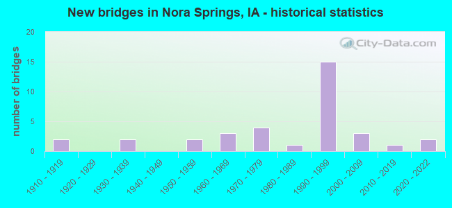
- New bridges - historical statistics
- 21910-1919
- 21930-1939
- 21950-1959
- 31960-1969
- 41970-1979
- 11980-1989
- 151990-1999
- 32000-2009
- 12010-2019
- 22020-2022

- Reconstructed bridges - Historical Statistics
- 11980-1989
- 01990-1999
- 02000-2009
- 12010-2019


- Bridge Condition - Deck
- 7.4%Excellent
- 11.1%Very good
- 33.3%Good
- 25.9%Satisfactory
- 14.8%Fair
- 7.4%Poor

- Bridge Condition - Superstructure
- 7.4%Excellent
- 29.6%Very good
- 22.2%Good
- 14.8%Satisfactory
- 14.8%Fair
- 7.4%Poor
- 3.7%Serious

- Bridge Condition - Substructure
- 7.4%Excellent
- 7.4%Very good
- 37.0%Good
- 25.9%Satisfactory
- 11.1%Fair
- 11.1%Poor

- Bridge Condition - Channel
- 7.1%Excellent
- 21.4%Very good
- 32.1%Good
- 28.6%Satisfactory
- 10.7%Fair

- Bridge Condition - Culverts
- 75.0%Very good
- 25.0%Satisfactory
Find on map >> Show street view
Structure Number: 8701, Location: 096180707 (Lat: 43.141817, Lng: -93.010044), Route carried "on" structure: City street , Year Built: 2020, Status: Open, Structure Length: 4.82m (15.81ft), Average Daily Traffic: 620 (year 2005), Average Future Daily Traffic: 620 (year 2041), Design Load: HL 93, Features Intersected: SHELL ROCK RIVER, Facility Carried by Structure: 1ST ST SW
Minimum Vertical Clearance: 30+ m (98+ ft), Kilometerpoint: 0.607, Lanes on structure: 2, Owner: City or Municipal Highway Agency, Approaching Roadway Width: 9.1m (29.9ft), Material/Design: Prestressed concrete, Design/Construction: Stringer/Multi-beam, Number Of Spans In Main Unit: 1, Length of Maximum Span: 47.2m (154.9ft), Curb or Sidewalk Widths: Left: 1.6m (5.2ft), Right: 0.0m, Curb-To-Curb Width: 10.5m (34.4ft), Out-to-Out Width: 13.2m (43.3ft)
Condition: Deck: Excellent, Superstructure: Excellent, Substructure: Excellent, Channel: Very good, Operating Rating: 42.1 metric tons, Method Used To Determine Operating Rating: Assigned ratings based on Load and Resistance Factor Design (LRFD) reported by rating factor (RF) using HL93 loadings, Inventory Rating: 32.4 metric tons, Method Used To Determine Inventory Rating: Assigned ratings based on Load and Resistance Factor Design (LRFD) reported by rating factor (RF) using HL93 loadings, Structural Evaluation: Equal to present desirable criteria, Deck Geometry: Equal to present minimum criteria, Waterway Adequacy: Better than present minimum criteria, Approach Roadway Alignment: Better than present minimum criteria, Designated Inspection Frequency: Every 24 months, Inspection Date: January 2021, Deck Structure Type: Concrete Cast-file-Place, Wearing Surface/Protective System: Wearing Surface: Monolithic Concrete, Deck Protection: Epoxy Coated Reinforcing
Find on map >> Show street view
Structure Number: 1465, Location: 000000000 (Lat: 42.472828, Lng: -92.261464), Route carried "on" structure: City street , Year Built: 1958, Status: Open, Structure Length: 5.61m (18.41ft), Average Daily Traffic: 2,425 (year 2021), Average Future Daily Traffic: 2,425 (year 2040), Design Load: H 20, Features Intersected: ELK RUN CREEK*, Facility Carried by Structure: DUBUQUE ROAD WEST
Minimum Vertical Clearance: 30+ m (98+ ft), Kilometerpoint: 0.027, Lanes on structure: 2, Owner: City or Municipal Highway Agency, Approaching Roadway Width: 12.2m (40.0ft), Skew: 10 degrees, Material/Design: Concrete continuous, Design/Construction: Tee Beam, Number Of Spans In Main Unit: 3, Length of Maximum Span: 22.3m (73.2ft), Curb or Sidewalk Widths: Left: 0.6m (2.0ft), Right: 0.6m (2.0ft), Curb-To-Curb Width: 8.5m (27.9ft), Out-to-Out Width: 10.5m (34.4ft)
Condition: Deck: Satisfactory, Superstructure: Satisfactory, Substructure: Satisfactory, Channel: Good, Operating Rating: 37.2 metric tons, Method Used To Determine Operating Rating: Load Factor (LF), Inventory Rating: 21.8 metric tons, Method Used To Determine Inventory Rating: Load Factor (LF), Structural Evaluation: Somewhat better than minimum adequacy, Deck Geometry: High priority of corrective action, Waterway Adequacy: Better than present minimum criteria, Approach Roadway Alignment: Equal to present desirable criteria, Length Of Structure Improvement: 22.00m (72.18ft), Designated Inspection Frequency: Every 24 months, Other Special Inspection Frequency: Every 12 months, Inspection Date: August 2020, Other Special Inspection Date: September 2014, Bridge Improvement Cost: $370,000, Roadway Improvement Cost: $70,000, Deck Structure Type: Concrete Cast-file-Place, Wearing Surface/Protective System: Wearing Surface: Monolithic Concrete
Find on map >> Show street view
Structure Number: 1885, Location: 096191205 (Lat: 43.147153, Lng: -93.029936), Route carried "on" structure: County highway , Year Built: 1955, Status: Posted for load, Structure Length: 7.07m (23.20ft), Average Daily Traffic: 2,800 (year 2021), Average Future Daily Traffic: 2,800 (year 2040), Design Load: H 20, Features Intersected: IANR RR, Facility Carried by Structure: CO RD B30
Minimum Vertical Clearance: 30+ m (98+ ft), Kilometerpoint: 7.741, Lanes on structure: 2, Owner: County Highway Agency, Approaching Roadway Width: 13.4m (44.0ft), Skew: 5 degrees, Material/Design: Steel continuous, Design/Construction: Stringer/Multi-beam, Number Of Spans In Main Unit: 3, Length of Maximum Span: 26.8m (87.9ft), Curb-To-Curb Width: 8.5m (27.9ft), Out-to-Out Width: 10.4m (34.1ft)
Condition: Deck: Satisfactory, Superstructure: Fair, Substructure: Satisfactory, Operating Rating: 30.0 metric tons, Method Used To Determine Operating Rating: Allowable Stress (AS), Inventory Rating: 15.8 metric tons, Method Used To Determine Inventory Rating: Allowable Stress (AS), Structural Evaluation: Meets minimum limits, Deck Geometry: Meets minimum limits, Underclear: Better than present minimum criteria, Approach Roadway Alignment: Equal to present minimum criteria, Bridge Posting: Required (Relationship of Operating Rating to Maximum Legal Load: 0.1 - 9.9% below), Length Of Structure Improvement: 26.60m (87.27ft), Designated Inspection Frequency: Every 24 months, Inspection Date: January 2020, Bridge Improvement Cost: $746,000, Roadway Improvement Cost: $149,000, Deck Structure Type: Concrete Cast-file-Place, Wearing Surface/Protective System: Wearing Surface: Low Slump Concrete
Find on map >> Show street view
Structure Number: 24901, Location: 096180707 (Lat: 43.142686, Lng: -93.010186), Route carried "on" structure: City street , Year Built: 2008, Status: Open, Structure Length: 9.39m (30.81ft), Average Daily Traffic: 4,040 (year 2021), Average Future Daily Traffic: 4,040 (year 2040), Design Load: HS 20, Features Intersected: SHELL ROCK RIVER, Facility Carried by Structure: CONGRESS ST
Minimum Vertical Clearance: 30+ m (98+ ft), Kilometerpoint: 1.215, Lanes on structure: 2, Owner: City or Municipal Highway Agency, Approaching Roadway Width: 11.0m (36.1ft), Material/Design: Prestressed concrete, Design/Construction: Stringer/Multi-beam, Number Of Spans In Main Unit: 3, Length of Maximum Span: 32.3m (106.0ft), Curb or Sidewalk Widths: Left: 0.0m, Right: 1.5m (4.9ft), Curb-To-Curb Width: 10.4m (34.1ft), Out-to-Out Width: 12.2m (40.0ft)
Condition: Deck: Satisfactory, Superstructure: Very good, Substructure: Very good, Channel: Very good, Operating Rating: 64.6 metric tons, Method Used To Determine Operating Rating: Load Factor (LF), Inventory Rating: 38.5 metric tons, Method Used To Determine Inventory Rating: Load Factor (LF), Structural Evaluation: Equal to present desirable criteria, Deck Geometry: Somewhat better than minimum adequacy, Waterway Adequacy: Superior to present desirable criteria, Approach Roadway Alignment: Better than present minimum criteria, Designated Inspection Frequency: Every 24 months, Inspection Date: March 2020, Deck Structure Type: Concrete Cast-file-Place, Wearing Surface/Protective System: Wearing Surface: Monolithic Concrete, Deck Protection: Epoxy Coated Reinforcing
Find on map >> Show street view
Structure Number: 106091, Location: 096192502 (Lat: 43.103058, Lng: -93.043436), Route carried "on" structure: County highway , Year Built: 1979, Status: Open, Structure Length: 2.50m (8.20ft), Average Daily Traffic: 15 (year 2021), Average Future Daily Traffic: 15 (year 2040), Design Load: H 20, Features Intersected: LITTLE LIME CREEK, Facility Carried by Structure: YARROW
Minimum Vertical Clearance: 30+ m (98+ ft), Kilometerpoint: 15.709, Lanes on structure: 2, Owner: County Highway Agency, Approaching Roadway Width: 9.8m (32.2ft), Material/Design: Prestressed concrete, Design/Construction: Stringer/Multi-beam, Number Of Spans In Main Unit: 1, Length of Maximum Span: 24.4m (80.1ft), Curb-To-Curb Width: 8.6m (28.2ft), Out-to-Out Width: 9.1m (29.9ft)
Condition: Deck: Good, Superstructure: Good, Substructure: Good, Channel: Good, Operating Rating: 53.9 metric tons, Method Used To Determine Operating Rating: Allowable Stress (AS), Inventory Rating: 22.5 metric tons, Method Used To Determine Inventory Rating: Allowable Stress (AS), Structural Evaluation: Equal to present minimum criteria, Deck Geometry: Better than present minimum criteria, Waterway Adequacy: Equal to present desirable criteria, Approach Roadway Alignment: Superior to present desirable criteria, Designated Inspection Frequency: Every 24 months, Inspection Date: January 2020, Deck Structure Type: Concrete Cast-file-Place, Wearing Surface/Protective System: Wearing Surface: Monolithic Concrete
Find on map >> Show street view
Structure Number: 106101, Location: 096192503 (Lat: 43.099858, Lng: -93.042033), Route carried "on" structure: County highway , Year Built: 1985, Status: Open, Structure Length: 2.32m (7.61ft), Average Daily Traffic: 40 (year 2021), Average Future Daily Traffic: 40 (year 2040), Design Load: H 20, Features Intersected: LITTLE LIME CREEK, Facility Carried by Structure: CLAY BANKS
Minimum Vertical Clearance: 30+ m (98+ ft), Kilometerpoint: 1.524, Lanes on structure: 2, Owner: County Highway Agency, Approaching Roadway Width: 7.3m (24.0ft), Material/Design: Concrete continuous, Design/Construction: Slab, Number Of Spans In Main Unit: 3, Length of Maximum Span: 8.8m (28.9ft), Curb-To-Curb Width: 8.5m (27.9ft), Out-to-Out Width: 9.1m (29.9ft)
Condition: Deck: Good, Superstructure: Good, Substructure: Good, Channel: Fair, Operating Rating: 55.7 metric tons, Method Used To Determine Operating Rating: Allowable Stress (AS), Inventory Rating: 33.2 metric tons, Method Used To Determine Inventory Rating: Allowable Stress (AS), Structural Evaluation: Better than present minimum criteria, Deck Geometry: Better than present minimum criteria, Waterway Adequacy: Superior to present desirable criteria, Approach Roadway Alignment: Equal to present desirable criteria, Designated Inspection Frequency: Every 24 months, Inspection Date: January 2020, Deck Structure Type: Concrete Cast-file-Place, Wearing Surface/Protective System: Wearing Surface: Monolithic Concrete
Find on map >> Show street view
Structure Number: 106111, Location: 096192602 (Lat: 43.104967, Lng: -93.063053), Route carried "on" structure: County highway , Year Built: 2001, Status: Open, Structure Length: 3.05m (10.01ft), Average Daily Traffic: 45 (year 2013), Average Future Daily Traffic: 45 (year 2040), Design Load: HS 20, Features Intersected: LITTLE LIME CREEK, Facility Carried by Structure: WARBLER
Minimum Vertical Clearance: 7.26m (23.82ft), Kilometerpoint: 18.176, Lanes on structure: 2, Owner: County Highway Agency, Approaching Roadway Width: 7.3m (24.0ft), Material/Design: Concrete continuous, Design/Construction: Slab, Number Of Spans In Main Unit: 3, Length of Maximum Span: 11.9m (39.0ft), Curb-To-Curb Width: 7.5m (24.6ft), Out-to-Out Width: 8.4m (27.6ft)
Condition: Deck: Very good, Superstructure: Good, Substructure: Very good, Channel: Very good, Operating Rating: 63.5 metric tons, Method Used To Determine Operating Rating: Load Factor (LF), Inventory Rating: 37.2 metric tons, Method Used To Determine Inventory Rating: Load Factor (LF), Structural Evaluation: Better than present minimum criteria, Deck Geometry: Equal to present minimum criteria, Waterway Adequacy: Equal to present desirable criteria, Approach Roadway Alignment: Equal to present desirable criteria, Designated Inspection Frequency: Every 24 months, Inspection Date: January 2020, Deck Structure Type: Concrete Cast-file-Place
Find on map >> Show street view
Structure Number: 106171, Location: 096193503 (Lat: 43.090222, Lng: -93.056597), Route carried "on" structure: County highway , Year Built: 2019, Status: Open, Structure Length: 0.79m (2.59ft), Average Daily Traffic: 30 (year 2013), Average Future Daily Traffic: 30 (year 2040), Design Load: HL 93, Features Intersected: BAD LANDS DRAW, Facility Carried by Structure: 225TH ST
Minimum Vertical Clearance: 30+ m (98+ ft), Kilometerpoint: 6.231, Lanes on structure: 2, Owner: County Highway Agency, Approaching Roadway Width: 6.7m (22.0ft), Material/Design: Concrete, Design/Construction: Culvert, Number Of Spans In Main Unit: 2, Length of Maximum Span: 3.7m (12.1ft)
Condition: Channel: Good, Culverts: Very good, Operating Rating: 59.3 metric tons, Method Used To Determine Operating Rating: Load and Resistance Factor Rating (LRFR) rating reported by rating factor(RF) method using HL-93 loadings, Inventory Rating: 45.7 metric tons, Method Used To Determine Inventory Rating: Load and Resistance Factor Rating (LRFR) rating reported by rating factor(RF) method using HL-93 loadings, Structural Evaluation: Equal to present desirable criteria, Waterway Adequacy: Better than present minimum criteria, Approach Roadway Alignment: Better than present minimum criteria, Designated Inspection Frequency: Every 24 months, Inspection Date: January 2020
Find on map >> Show street view
Structure Number: 10618, Location: 096193504 (Lat: 43.097067, Lng: -93.053153), Route carried "on" structure: County highway , Year Built: 1935, Status: Posted for load, Structure Length: 4.57m (14.99ft), Average Daily Traffic: 30 (year 2013), Average Future Daily Traffic: 30 (year 2040), Design Load: H 15, Features Intersected: WINNEBAGO RIVER, Facility Carried by Structure: WREN
Minimum Vertical Clearance: 30+ m (98+ ft), Kilometerpoint: 3.336, Lanes on structure: 2, Owner: County Highway Agency, Approaching Roadway Width: 7.3m (24.0ft), Material/Design: Steel continuous, Design/Construction: Stringer/Multi-beam, Number Of Spans In Main Unit: 3, Length of Maximum Span: 17.7m (58.1ft), Curb-To-Curb Width: 6.0m (19.7ft), Out-to-Out Width: 6.5m (21.3ft)
Condition: Deck: Fair, Superstructure: Satisfactory, Substructure: Satisfactory, Channel: Satisfactory, Operating Rating: 22.5 metric tons, Method Used To Determine Operating Rating: Allowable Stress (AS), Inventory Rating: 12.6 metric tons, Method Used To Determine Inventory Rating: Allowable Stress (AS), Structural Evaluation: Meets minimum limits, Deck Geometry: Meets minimum limits, Waterway Adequacy: Equal to present desirable criteria, Approach Roadway Alignment: Better than present minimum criteria, Bridge Posting: Required (Relationship of Operating Rating to Maximum Legal Load: 20.0 - 29.9% below), Length Of Structure Improvement: 18.30m (60.04ft), Designated Inspection Frequency: Every 24 months, Inspection Date: January 2020, Bridge Improvement Cost: $395,000, Roadway Improvement Cost: $59,000, Deck Structure Type: Concrete Cast-file-Place, Wearing Surface/Protective System: Wearing Surface: Monolithic Concrete
Find on map >> Show street view
Structure Number: 15556, Location: 096180302 (Lat: 43.161386, Lng: -92.964922), Route carried "on" structure: County highway , Year Built: 1967, Status: Open, Structure Length: 3.90m (12.80ft), Average Daily Traffic: 45 (year 2017), Average Future Daily Traffic: 45 (year 2041), Design Load: H 20, Features Intersected: FLOOD CREEK, Facility Carried by Structure: LOCAL
Minimum Vertical Clearance: 30+ m (98+ ft), Kilometerpoint: 23.236, Lanes on structure: 2, Owner: County Highway Agency, Approaching Roadway Width: 9.1m (29.9ft), Skew: 3 degrees, Material/Design: Concrete continuous, Design/Construction: Slab, Number Of Spans In Main Unit: 3, Length of Maximum Span: 14.9m (48.9ft), Curb-To-Curb Width: 8.5m (27.9ft), Out-to-Out Width: 9.2m (30.2ft)
Condition: Deck: Satisfactory, Superstructure: Satisfactory, Substructure: Satisfactory, Channel: Good, Operating Rating: 52.2 metric tons, Method Used To Determine Operating Rating: Allowable Stress (AS), Inventory Rating: 30.4 metric tons, Method Used To Determine Inventory Rating: Allowable Stress (AS), Structural Evaluation: Equal to present minimum criteria, Deck Geometry: Better than present minimum criteria, Waterway Adequacy: Equal to present desirable criteria, Approach Roadway Alignment: Equal to present minimum criteria, Length Of Structure Improvement: 12.50m (41.01ft), Designated Inspection Frequency: Every 24 months, Inspection Date: March 2021, Bridge Improvement Cost: $15,000, Roadway Improvement Cost: $2,000, Deck Structure Type: Concrete Cast-file-Place, Wearing Surface/Protective System: Wearing Surface: Monolithic Concrete
Find on map >> Show street view
Structure Number: 155571, Location: 096181001 (Lat: 43.155342, Lng: -92.962181), Route carried "on" structure: County highway , Year Built: 1976, Status: Open, Structure Length: 3.87m (12.70ft), Average Daily Traffic: 25 (year 2017), Average Future Daily Traffic: 25 (year 2041), Design Load: H 15, Features Intersected: FLOOD CREEK, Facility Carried by Structure: LOCAL RD
Minimum Vertical Clearance: 30+ m (98+ ft), Kilometerpoint: 1.825, Lanes on structure: 2, Owner: County Highway Agency, Approaching Roadway Width: 7.9m (25.9ft), Material/Design: Concrete continuous, Design/Construction: Slab, Number Of Spans In Main Unit: 3, Length of Maximum Span: 14.9m (48.9ft), Curb or Sidewalk Widths: Left: 0.3m (1.0ft), Right: 0.3m (1.0ft), Curb-To-Curb Width: 7.3m (24.0ft), Out-to-Out Width: 8.0m (26.2ft)
Condition: Deck: Satisfactory, Superstructure: Satisfactory, Substructure: Fair, Channel: Good, Operating Rating: 37.2 metric tons, Method Used To Determine Operating Rating: Load Factor (LF), Inventory Rating: 22.3 metric tons, Method Used To Determine Inventory Rating: Load Factor (LF), Structural Evaluation: Somewhat better than minimum adequacy, Deck Geometry: Equal to present minimum criteria, Waterway Adequacy: Better than present minimum criteria, Approach Roadway Alignment: Better than present minimum criteria, Length Of Structure Improvement: 12.70m (41.67ft), Designated Inspection Frequency: Every 24 months, Inspection Date: March 2021, Bridge Improvement Cost: $15,000, Roadway Improvement Cost: $2,000, Deck Structure Type: Concrete Cast-file-Place, Wearing Surface/Protective System: Wearing Surface: Monolithic Concrete
Find on map >> Show street view
Structure Number: 155641, Location: 096181704 (Lat: 43.140375, Lng: -92.992119), Route carried "on" structure: County highway , Year Built: 1994, Status: Open, Structure Length: 0.64m (2.10ft), Average Daily Traffic: 50 (year 2017), Average Future Daily Traffic: 50 (year 2040), Design Load: HS 20, Features Intersected: SMALL STREAM, Facility Carried by Structure: LOCAL
Minimum Vertical Clearance: 30+ m (98+ ft), Kilometerpoint: 0.629, Lanes on structure: 2, Owner: County Highway Agency, Approaching Roadway Width: 7.3m (24.0ft), Material/Design: Concrete continuous, Design/Construction: Culvert, Number Of Spans In Main Unit: 2, Length of Maximum Span: 3.0m (9.8ft)
Condition: Channel: Very good, Culverts: Very good, Operating Rating: 44.1 metric tons, Method Used To Determine Operating Rating: Assigned rating based on Load Factor Design (LFD) reported in metric tons, Inventory Rating: 32.7 metric tons, Method Used To Determine Inventory Rating: Assigned rating based on Load Factor Design (LFD) reported in metric tons, Structural Evaluation: Equal to present desirable criteria, Waterway Adequacy: Equal to present desirable criteria, Approach Roadway Alignment: Equal to present minimum criteria, Length Of Structure Improvement: 2.40m (7.87ft), Designated Inspection Frequency: Every 48 months, Inspection Date: March 2020, Bridge Improvement Cost: $15,000, Roadway Improvement Cost: $2,000
Find on map >> Show street view
Structure Number: 15566, Location: 096181912 (Lat: 43.120675, Lng: -93.009214), Route carried "on" structure: County highway , Year Built: 1916, Status: Posted for load, Structure Length: 0.73m (2.40ft), Average Daily Traffic: 80 (year 2017), Average Future Daily Traffic: 80 (year 2041), Features Intersected: SMALL CREEK, Facility Carried by Structure: LOCAL
Minimum Vertical Clearance: 30+ m (98+ ft), Kilometerpoint: 2.486, Lanes on structure: 2, Owner: County Highway Agency, Approaching Roadway Width: 9.1m (29.9ft), Skew: 2 degrees, Material/Design: Concrete, Design/Construction: Stringer/Multi-beam, Number Of Spans In Main Unit: 1, Length of Maximum Span: 7.0m (23.0ft), Curb-To-Curb Width: 8.2m (26.9ft), Out-to-Out Width: 8.7m (28.5ft)
Condition: Deck: Poor, Superstructure: Serious, Substructure: Poor, Channel: Fair, Operating Rating: 20.9 metric tons, Method Used To Determine Operating Rating: Allowable Stress (AS), Inventory Rating: 11.0 metric tons, Method Used To Determine Inventory Rating: Allowable Stress (AS), Structural Evaluation: High priority of corrective action, Deck Geometry: Equal to present minimum criteria, Waterway Adequacy: Equal to present minimum criteria, Approach Roadway Alignment: Better than present minimum criteria, Bridge Posting: Required (Relationship of Operating Rating to Maximum Legal Load: 30.0 - 39.9% below), Length Of Structure Improvement: 7.50m (24.61ft), Designated Inspection Frequency: Every 12 months, Inspection Date: March 2021, Bridge Improvement Cost: $203,000, Roadway Improvement Cost: $20,000, Deck Structure Type: Concrete Cast-file-Place, Wearing Surface/Protective System: Wearing Surface: Other
Find on map >> Show street view
Structure Number: 155711, Location: 096182701 (Lat: 43.111869, Lng: -92.958911), Route carried "on" structure: County highway , Year Built: 1977, Status: Open, Structure Length: 1.04m (3.41ft), Average Daily Traffic: 20 (year 2017), Average Future Daily Traffic: 20 (year 2041), Design Load: H 20, Features Intersected: CREEK, Facility Carried by Structure: LOCAL
Minimum Vertical Clearance: 30+ m (98+ ft), Kilometerpoint: 0.483, Lanes on structure: 2, Owner: County Highway Agency, Approaching Roadway Width: 7.9m (25.9ft), Skew: 5 degrees, Material/Design: Steel, Design/Construction: Culvert, Number Of Spans In Main Unit: 1, Length of Maximum Span: 10.4m (34.1ft)
Condition: Channel: Good, Culverts: Satisfactory, Operating Rating: 40.9 metric tons, Method Used To Determine Operating Rating: Load Factor (LF), Inventory Rating: 32.7 metric tons, Method Used To Determine Inventory Rating: Load Factor (LF), Structural Evaluation: Equal to present minimum criteria, Waterway Adequacy: Equal to present desirable criteria, Approach Roadway Alignment: Equal to present minimum criteria, Length Of Structure Improvement: 3.40m (11.15ft), Designated Inspection Frequency: Every 48 months, Inspection Date: March 2021, Bridge Improvement Cost: $15,000, Roadway Improvement Cost: $2,000
Find on map >> Show street view
Structure Number: 155721, Location: 096182702 (Lat: 43.104994, Lng: -92.964711), Route carried "on" structure: County highway , Year Built: 1991, Status: Open, Structure Length: 1.40m (4.59ft), Average Daily Traffic: 35 (year 2017), Average Future Daily Traffic: 35 (year 2041), Design Load: HS 20, Features Intersected: CREEK, Facility Carried by Structure: LOCAL
Minimum Vertical Clearance: 30+ m (98+ ft), Kilometerpoint: 16.972, Lanes on structure: 2, Owner: County Highway Agency, Approaching Roadway Width: 6.1m (20.0ft), Skew: 3 degrees, Material/Design: Prestressed concrete, Design/Construction: Tee Beam, Number Of Spans In Main Unit: 1, Length of Maximum Span: 13.7m (44.9ft), Curb-To-Curb Width: 8.4m (27.6ft), Out-to-Out Width: 8.5m (27.9ft)
Condition: Deck: Very good, Superstructure: Very good, Substructure: Fair, Channel: Satisfactory, Operating Rating: 78.8 metric tons, Method Used To Determine Operating Rating: Load Factor (LF), Inventory Rating: 42.8 metric tons, Method Used To Determine Inventory Rating: Load Factor (LF), Structural Evaluation: Somewhat better than minimum adequacy, Deck Geometry: Equal to present minimum criteria, Waterway Adequacy: Equal to present desirable criteria, Approach Roadway Alignment: Equal to present desirable criteria, Length Of Structure Improvement: 4.60m (15.09ft), Designated Inspection Frequency: Every 24 months, Inspection Date: March 2021, Bridge Improvement Cost: $15,000, Roadway Improvement Cost: $2,000, Deck Structure Type: Concrete Precast Panels, Wearing Surface/Protective System: Wearing Surface: Monolithic Concrete
Find on map >> Show street view
Structure Number: 15575, Location: 096183108 (Lat: 43.086433, Lng: -93.023761), Route carried "on" structure: County highway , Year Built: 1964, Year Reconstructed: 2016, Status: Open, Structure Length: 6.68m (21.92ft), Average Daily Traffic: 450 (year 2021), Truck Traffic: 9%, Average Future Daily Traffic: 450 (year 2041), Design Load: H 20, Features Intersected: WINNEBAGO RIVER, Facility Carried by Structure: FM
Minimum Vertical Clearance: 30+ m (98+ ft), Kilometerpoint: 19.705, Lanes on structure: 2, Owner: County Highway Agency, Approaching Roadway Width: 9.8m (32.2ft), Material/Design: Prestressed concrete, Design/Construction: Stringer/Multi-beam, Number Of Spans In Main Unit: 3, Length of Maximum Span: 24.7m (81.0ft), Curb-To-Curb Width: 8.5m (27.9ft), Out-to-Out Width: 9.2m (30.2ft)
Condition: Deck: Satisfactory, Superstructure: Poor, Substructure: Fair, Channel: Satisfactory, Operating Rating: 54.3 metric tons, Method Used To Determine Operating Rating: Allowable Stress (AS), Inventory Rating: 21.8 metric tons, Method Used To Determine Inventory Rating: Allowable Stress (AS), Structural Evaluation: Meets minimum limits, Deck Geometry: Somewhat better than minimum adequacy, Waterway Adequacy: Equal to present desirable criteria, Approach Roadway Alignment: Better than present minimum criteria, Length Of Structure Improvement: 21.80m (71.52ft), Designated Inspection Frequency: Every 24 months, Inspection Date: March 2021, Bridge Improvement Cost: $15,000, Roadway Improvement Cost: $2,000, Deck Structure Type: Concrete Cast-file-Place, Wearing Surface/Protective System: Wearing Surface: Monolithic Concrete
Find on map >> Show street view
Structure Number: 15576, Location: 096183301 (Lat: 43.097417, Lng: -92.983417), Route carried "on" structure: County highway , Year Built: 1938, Status: Posted for load, Structure Length: 5.18m (16.99ft), Average Daily Traffic: 80 (year 2021), Average Future Daily Traffic: 80 (year 2040), Design Load: H 15, Features Intersected: SHELL ROCK RIVER, Facility Carried by Structure: FM
Minimum Vertical Clearance: 30+ m (98+ ft), Kilometerpoint: 3.281, Lanes on structure: 2, Owner: County Highway Agency, Approaching Roadway Width: 7.3m (24.0ft), Material/Design: Steel continuous, Design/Construction: Girder and Floorbeam System, Number Of Spans In Main Unit: 2, Length of Maximum Span: 25.9m (85.0ft), Curb-To-Curb Width: 6.1m (20.0ft), Out-to-Out Width: 6.5m (21.3ft)
Condition: Deck: Poor, Superstructure: Poor, Substructure: Satisfactory, Channel: Satisfactory, Operating Rating: 27.6 metric tons, Method Used To Determine Operating Rating: Allowable Stress (AS), Inventory Rating: 17.3 metric tons, Method Used To Determine Inventory Rating: Allowable Stress (AS), Structural Evaluation: Meets minimum limits, Deck Geometry: Somewhat better than minimum adequacy, Waterway Adequacy: Better than present minimum criteria, Approach Roadway Alignment: Better than present minimum criteria, Bridge Posting: Required (Relationship of Operating Rating to Maximum Legal Load: 10.0 - 19.9% below), Length Of Structure Improvement: 21.70m (71.19ft), Designated Inspection Frequency: Every 24 months, Critical Feature Inspection Frequency: Every 24 months, Inspection Date: March 2020, Critical Feature Inspection Date: July 2020, Bridge Improvement Cost: $618,000, Roadway Improvement Cost: $62,000, Deck Structure Type: Concrete Cast-file-Place, Wearing Surface/Protective System: Wearing Surface: Monolithic Concrete
Find on map >> Show street view
Structure Number: 15608, Location: 097181903 (Lat: 43.205558, Lng: -93.018019), Route carried "on" structure: County highway , Year Built: 1964, Year Reconstructed: 1988, Status: Open, Structure Length: 0.88m (2.89ft), Average Daily Traffic: 170 (year 2021), Truck Traffic: 15%, Average Future Daily Traffic: 170 (year 2041), Design Load: HS 20, Features Intersected: LOST WATER CREEK, Facility Carried by Structure: FM
Minimum Vertical Clearance: 30+ m (98+ ft), Kilometerpoint: 0.489, Lanes on structure: 2, Owner: County Highway Agency, Approaching Roadway Width: 9.8m (32.2ft), Material/Design: Prestressed concrete, Design/Construction: Tee Beam, Number Of Spans In Main Unit: 1, Length of Maximum Span: 8.5m (27.9ft), Curb-To-Curb Width: 8.5m (27.9ft), Out-to-Out Width: 9.0m (29.5ft)
Condition: Deck: Fair, Superstructure: Fair, Substructure: Satisfactory, Channel: Satisfactory, Inventory Rating: 55.0 metric tons, Method Used To Determine Inventory Rating: Load Factor (LF), Structural Evaluation: Somewhat better than minimum adequacy, Deck Geometry: Equal to present minimum criteria, Waterway Adequacy: Equal to present minimum criteria, Approach Roadway Alignment: Equal to present desirable criteria, Length Of Structure Improvement: 2.90m (9.51ft), Designated Inspection Frequency: Every 24 months, Inspection Date: March 2021, Bridge Improvement Cost: $15,000, Roadway Improvement Cost: $2,000, Deck Structure Type: Concrete Precast Panels, Wearing Surface/Protective System: Wearing Surface: Monolithic Concrete
Find on map >> Show street view
Structure Number: 156095, Location: 097182001 (Lat: 43.212758, Lng: -93.000031), Route carried "on" structure: County highway , Year Built: 1996, Status: Open, Structure Length: 0.67m (2.20ft), Average Daily Traffic: 45 (year 2021), Average Future Daily Traffic: 45 (year 2040), Design Load: HS 20, Features Intersected: SMALL STREAM, Facility Carried by Structure: LOCAL
Minimum Vertical Clearance: 30+ m (98+ ft), Kilometerpoint: 1.955, Lanes on structure: 2, Owner: County Highway Agency, Approaching Roadway Width: 6.1m (20.0ft), Material/Design: Prestressed concrete, Design/Construction: Slab, Number Of Spans In Main Unit: 1, Length of Maximum Span: 6.4m (21.0ft), Curb-To-Curb Width: 8.3m (27.2ft), Out-to-Out Width: 8.4m (27.6ft)
Condition: Deck: Good, Superstructure: Good, Substructure: Good, Channel: Good, Operating Rating: 61.2 metric tons, Method Used To Determine Operating Rating: Load Factor (LF), Inventory Rating: 36.6 metric tons, Method Used To Determine Inventory Rating: Load Factor (LF), Structural Evaluation: Better than present minimum criteria, Deck Geometry: Equal to present minimum criteria, Waterway Adequacy: Equal to present minimum criteria, Approach Roadway Alignment: Equal to present desirable criteria, Length Of Structure Improvement: 2.20m (7.22ft), Designated Inspection Frequency: Every 48 months, Inspection Date: March 2020, Bridge Improvement Cost: $15,000, Roadway Improvement Cost: $2,000, Deck Structure Type: Concrete Precast Panels, Wearing Surface/Protective System: Wearing Surface: Monolithic Concrete
Find on map >> Show street view
Structure Number: 156101, Location: 097182002 (Lat: 43.210892, Lng: -93.004267), Route carried "on" structure: County highway , Year Built: 2020, Status: Open, Structure Length: 2.56m (8.40ft), Average Daily Traffic: 570 (year 2021), Truck Traffic: 16%, Average Future Daily Traffic: 570 (year 2041), Design Load: HL 93, Features Intersected: FLOOD CREEK, Facility Carried by Structure: S70 BALSAM AVE
Minimum Vertical Clearance: 30+ m (98+ ft), Kilometerpoint: 22.314, Lanes on structure: 2, Owner: County Highway Agency, Approaching Roadway Width: 9.8m (32.2ft), Skew: 3 degrees, Material/Design: Concrete continuous, Design/Construction: Slab, Number Of Spans In Main Unit: 3, Length of Maximum Span: 9.4m (30.8ft), Curb-To-Curb Width: 9.1m (29.9ft), Out-to-Out Width: 10.1m (33.1ft)
Condition: Deck: Excellent, Superstructure: Excellent, Substructure: Excellent, Channel: Very good, Operating Rating: 42.1 metric tons, Method Used To Determine Operating Rating: Assigned ratings based on Load and Resistance Factor Design (LRFD) reported by rating factor (RF) using HL93 loadings, Inventory Rating: 32.4 metric tons, Method Used To Determine Inventory Rating: Assigned ratings based on Load and Resistance Factor Design (LRFD) reported by rating factor (RF) using HL93 loadings, Structural Evaluation: Equal to present desirable criteria, Deck Geometry: Equal to present minimum criteria, Waterway Adequacy: Better than present minimum criteria, Approach Roadway Alignment: Equal to present desirable criteria, Designated Inspection Frequency: Every 24 months, Inspection Date: March 2021, Deck Structure Type: Concrete Cast-file-Place, Wearing Surface/Protective System: Wearing Surface: Monolithic Concrete
Find on map >> Show street view
Structure Number: 156111, Location: 097182901 (Lat: 43.198256, Lng: -92.997658), Route carried "on" structure: County highway , Year Built: 1996, Status: Open, Structure Length: 1.52m (4.99ft), Average Daily Traffic: 50 (year 2017), Average Future Daily Traffic: 50 (year 2039), Design Load: HS 20, Features Intersected: FLOOD CREEK, Facility Carried by Structure: LOCAL
Minimum Vertical Clearance: 30+ m (98+ ft), Kilometerpoint: 0.534, Lanes on structure: 2, Owner: County Highway Agency, Approaching Roadway Width: 7.9m (25.9ft), Skew: 4 degrees, Material/Design: Prestressed concrete, Design/Construction: Tee Beam, Number Of Spans In Main Unit: 1, Length of Maximum Span: 14.6m (47.9ft), Curb-To-Curb Width: 8.5m (27.9ft), Out-to-Out Width: 8.6m (28.2ft)
Condition: Deck: Very good, Superstructure: Very good, Substructure: Good, Channel: Satisfactory, Operating Rating: 62.2 metric tons, Method Used To Determine Operating Rating: Load Factor (LF), Inventory Rating: 36.1 metric tons, Method Used To Determine Inventory Rating: Load Factor (LF), Structural Evaluation: Better than present minimum criteria, Deck Geometry: Better than present minimum criteria, Waterway Adequacy: Better than present minimum criteria, Approach Roadway Alignment: Equal to present desirable criteria, Length Of Structure Improvement: 5.00m (16.40ft), Designated Inspection Frequency: Every 48 months, Inspection Date: April 2019, Bridge Improvement Cost: $15,000, Roadway Improvement Cost: $2,000, Deck Structure Type: Concrete Cast-file-Place
Find on map >> Show street view
Structure Number: 156131, Location: 097182902 (Lat: 43.197739, Lng: -93.004242), Route carried "on" structure: County highway , Year Built: 1996, Status: Posted for load, Structure Length: 1.74m (5.71ft), Average Daily Traffic: 890 (year 2021), Truck Traffic: 10%, Average Future Daily Traffic: 890 (year 2041), Design Load: H 15, Features Intersected: LOST WATER CREEK, Facility Carried by Structure: FM
Minimum Vertical Clearance: 30+ m (98+ ft), Kilometerpoint: 20.854, Lanes on structure: 2, Owner: County Highway Agency, Approaching Roadway Width: 9.8m (32.2ft), Material/Design: Prestressed concrete, Design/Construction: Stringer/Multi-beam, Number Of Spans In Main Unit: 1, Length of Maximum Span: 16.8m (55.1ft), Curb-To-Curb Width: 9.1m (29.9ft), Out-to-Out Width: 9.9m (32.5ft)
Condition: Deck: Satisfactory, Superstructure: Good, Substructure: Satisfactory, Channel: Satisfactory, Operating Rating: 34.3 metric tons, Method Used To Determine Operating Rating: Allowable Stress (AS), Inventory Rating: 13.5 metric tons, Method Used To Determine Inventory Rating: Allowable Stress (AS), Structural Evaluation: Meets minimum limits, Deck Geometry: Equal to present minimum criteria, Waterway Adequacy: Better than present minimum criteria, Approach Roadway Alignment: Better than present minimum criteria, Bridge Posting: Required (Relationship of Operating Rating to Maximum Legal Load: 0.1 - 9.9% below), Length Of Structure Improvement: 5.70m (18.70ft), Designated Inspection Frequency: Every 24 months, Inspection Date: March 2021, Bridge Improvement Cost: $15,000, Roadway Improvement Cost: $2,000, Deck Structure Type: Concrete Cast-file-Place, Wearing Surface/Protective System: Wearing Surface: Monolithic Concrete
Find on map >> Show street view
Structure Number: 15614, Location: 097183201 (Lat: 43.183567, Lng: -92.990258), Route carried "on" structure: County highway , Year Built: 1970, Status: Open, Structure Length: 1.52m (4.99ft), Average Daily Traffic: 20 (year 2017), Average Future Daily Traffic: 20 (year 2041), Design Load: H 15, Features Intersected: FLOOD CREEK, Facility Carried by Structure: LOCAL
Minimum Vertical Clearance: 30+ m (98+ ft), Kilometerpoint: 1.151, Lanes on structure: 2, Owner: County Highway Agency, Approaching Roadway Width: 6.7m (22.0ft), Material/Design: Concrete, Design/Construction: Channel Beam, Number Of Spans In Main Unit: 2, Length of Maximum Span: 7.3m (24.0ft), Curb-To-Curb Width: 9.3m (30.5ft), Out-to-Out Width: 9.8m (32.2ft)
Condition: Deck: Fair, Superstructure: Fair, Substructure: Poor, Channel: Satisfactory, Operating Rating: 43.1 metric tons, Method Used To Determine Operating Rating: Allowable Stress (AS), Inventory Rating: 28.0 metric tons, Method Used To Determine Inventory Rating: Allowable Stress (AS), Structural Evaluation: Meets minimum limits, Deck Geometry: Better than present minimum criteria, Waterway Adequacy: Better than present minimum criteria, Approach Roadway Alignment: Equal to present desirable criteria, Length Of Structure Improvement: 5.00m (16.40ft), Designated Inspection Frequency: Every 24 months, Inspection Date: March 2021, Bridge Improvement Cost: $15,000, Roadway Improvement Cost: $2,000, Deck Structure Type: Concrete Precast Panels, Wearing Surface/Protective System: Wearing Surface: Monolithic Concrete
Find on map >> Show street view
Structure Number: 156151, Location: 097183301 (Lat: 43.183672, Lng: -92.978528), Route carried "on" structure: County highway , Year Built: 2007, Status: Open, Structure Length: 0.64m (2.10ft), Average Daily Traffic: 20 (year 2017), Average Future Daily Traffic: 20 (year 2040), Design Load: HS 20, Features Intersected: CREEK, Facility Carried by Structure: LOCAL
Minimum Vertical Clearance: 30+ m (98+ ft), Kilometerpoint: 2.105, Lanes on structure: 2, Owner: County Highway Agency, Approaching Roadway Width: 7.3m (24.0ft), Material/Design: Concrete continuous, Design/Construction: Culvert, Number Of Spans In Main Unit: 2, Length of Maximum Span: 3.0m (9.8ft)
Condition: Channel: Good, Culverts: Very good, Operating Rating: 44.1 metric tons, Method Used To Determine Operating Rating: Assigned rating based on Load Factor Design (LFD) reported in metric tons, Inventory Rating: 32.7 metric tons, Method Used To Determine Inventory Rating: Assigned rating based on Load Factor Design (LFD) reported in metric tons, Structural Evaluation: Equal to present desirable criteria, Waterway Adequacy: Equal to present desirable criteria, Approach Roadway Alignment: Equal to present desirable criteria, Length Of Structure Improvement: 2.10m (6.89ft), Designated Inspection Frequency: Every 48 months, Inspection Date: March 2020, Bridge Improvement Cost: $15,000, Roadway Improvement Cost: $2,000
Find on map >> Show street view
Structure Number: 15616, Location: 097183302 (Lat: 43.180308, Lng: -92.984639), Route carried "on" structure: County highway , Year Built: 1913, Status: Posted for load, Structure Length: 1.07m (3.51ft), Average Daily Traffic: 45 (year 2017), Average Future Daily Traffic: 45 (year 2041), Features Intersected: FLOOD CREEK, Facility Carried by Structure: LOCAL
Minimum Vertical Clearance: 30+ m (98+ ft), Kilometerpoint: 14.576, Lanes on structure: 2, Owner: County Highway Agency, Approaching Roadway Width: 6.4m (21.0ft), Skew: 3 degrees, Material/Design: Concrete, Design/Construction: Stringer/Multi-beam, Number Of Spans In Main Unit: 1, Length of Maximum Span: 10.1m (33.1ft), Curb-To-Curb Width: 5.5m (18.0ft), Out-to-Out Width: 6.6m (21.7ft)
Condition: Deck: Fair, Superstructure: Fair, Substructure: Poor, Channel: Fair, Operating Rating: 23.5 metric tons, Method Used To Determine Operating Rating: Allowable Stress (AS), Inventory Rating: 13.3 metric tons, Method Used To Determine Inventory Rating: Allowable Stress (AS), Structural Evaluation: Meets minimum limits, Deck Geometry: Meets minimum limits, Waterway Adequacy: Somewhat better than minimum adequacy, Approach Roadway Alignment: Better than present minimum criteria, Bridge Posting: Required (Relationship of Operating Rating to Maximum Legal Load: 0.1 - 9.9% below), Length Of Structure Improvement: 7.50m (24.61ft), Designated Inspection Frequency: Every 24 months, Inspection Date: March 2021, Bridge Improvement Cost: $203,000, Roadway Improvement Cost: $20,000, Deck Structure Type: Concrete Cast-file-Place, Wearing Surface/Protective System: Wearing Surface: Gravel
Find on map >> Show street view
Structure Number: 60647, Location: At the Jct. SR S70 (Lat: 43.116078, Lng: -93.023528), Route carried "on" structure: County highway , Year Built: 1999, Status: Open, Structure Length: 6.86m (22.51ft), Average Daily Traffic: 710 (year 2017), Truck Traffic: 7%, Average Future Daily Traffic: 710 (year 2040), Design Load: HS 20, Features Intersected: US 18, Facility Carried by Structure: CO RD S 70
Minimum Vertical Clearance: 30+ m (98+ ft), Kilometerpoint: 23.044, Lanes on structure: 2, Lanes under structure: 4, Owner: State Highway Agency, Approaching Roadway Width: 11.6m (38.1ft), Material/Design: Prestressed concrete, Design/Construction: Stringer/Multi-beam, Number Of Spans In Main Unit: 2, Length of Maximum Span: 33.8m (110.9ft), Curb-To-Curb Width: 10.2m (33.5ft), Out-to-Out Width: 11.2m (36.7ft)
Condition: Deck: Good, Superstructure: Very good, Substructure: Good, Operating Rating: 83.1 metric tons, Method Used To Determine Operating Rating: Load Factor (LF), Inventory Rating: 31.8 metric tons, Method Used To Determine Inventory Rating: Load Factor (LF), Structural Evaluation: Better than present minimum criteria, Deck Geometry: Equal to present minimum criteria, Underclear: Meets minimum limits, Approach Roadway Alignment: Better than present minimum criteria, Designated Inspection Frequency: Every 24 months, Inspection Date: July 2020, Deck Structure Type: Concrete Cast-file-Place, Wearing Surface/Protective System: Wearing Surface: Monolithic Concrete, Deck Protection: Epoxy Coated Reinforcing
Find on map >> Show street view
Structure Number: 606615, Location: 1.1 mi. E of Jct. SR S70 (Lat: 43.116639, Lng: -93.003378), Route carried "on" structure: US 18, Year Built: 1998, Status: Open, Structure Length: 18.41m (60.40ft), Average Daily Traffic: 5,200 (year 2020), Truck Traffic: 23%, Average Future Daily Traffic: 5,200 (year 2040), Design Load: HS 20, Features Intersected: IA NORTHERN RR & STREAM
Minimum Vertical Clearance: 30+ m (98+ ft), Kilometerpoint: 316.418, Lanes on structure: 2, Base Highway Network: Yes, Owner: State Highway Agency, Approaching Roadway Width: 14.0m (45.9ft), Material/Design: Prestressed concrete, Design/Construction: Stringer/Multi-beam, Number Of Spans In Main Unit: 6, Length of Maximum Span: 35.7m (117.1ft), Curb-To-Curb Width: 12.0m (39.4ft), Out-to-Out Width: 13.0m (42.7ft)
Condition: Deck: Good, Superstructure: Very good, Substructure: Good, Channel: Excellent, Operating Rating: 66.3 metric tons, Method Used To Determine Operating Rating: Load Factor (LF), Inventory Rating: 33.5 metric tons, Method Used To Determine Inventory Rating: Load Factor (LF), Structural Evaluation: Better than present minimum criteria, Deck Geometry: Better than present minimum criteria, Underclear: Superior to present desirable criteria, Approach Roadway Alignment: Equal to present desirable criteria, Designated Inspection Frequency: Every 24 months, Inspection Date: July 2020, Deck Structure Type: Concrete Cast-file-Place, Wearing Surface/Protective System: Wearing Surface: Monolithic Concrete, Deck Protection: Epoxy Coated Reinforcing
Find on map >> Show street view
Structure Number: 60662, Location: 1.1 mi. E of Jct SR S70 (Lat: 43.116825, Lng: -93.001108), Route carried "on" structure: US 18, Year Built: 1998, Status: Open, Structure Length: 18.41m (60.40ft), Average Daily Traffic: 5,200 (year 2020), Truck Traffic: 23%, Average Future Daily Traffic: 5,200 (year 2040), Design Load: HS 20, Features Intersected: IA NORTHERN RR & STREAM
Minimum Vertical Clearance: 30+ m (98+ ft), Kilometerpoint: 184.783, Lanes on structure: 2, Owner: State Highway Agency, Approaching Roadway Width: 14.0m (45.9ft), Material/Design: Prestressed concrete, Design/Construction: Stringer/Multi-beam, Number Of Spans In Main Unit: 6, Length of Maximum Span: 36.9m (121.1ft), Curb-To-Curb Width: 12.0m (39.4ft), Out-to-Out Width: 13.0m (42.7ft)
Condition: Deck: Good, Superstructure: Very good, Substructure: Good, Channel: Excellent, Operating Rating: 62.0 metric tons, Method Used To Determine Operating Rating: Load Factor (LF), Inventory Rating: 39.0 metric tons, Method Used To Determine Inventory Rating: Load Factor (LF), Structural Evaluation: Better than present minimum criteria, Deck Geometry: Better than present minimum criteria, Underclear: Superior to present desirable criteria, Waterway Adequacy: Superior to present desirable criteria, Approach Roadway Alignment: Equal to present desirable criteria, Designated Inspection Frequency: Every 24 months, Inspection Date: July 2020, Deck Structure Type: Concrete Cast-file-Place, Wearing Surface/Protective System: Wearing Surface: Monolithic Concrete, Deck Protection: Epoxy Coated Reinforcing
Find on map >> Show street view
Structure Number: 606625, Location: 1.5 mi. E of SR S70 (Lat: 43.116481, Lng: -92.994600), Route carried "on" structure: US 18, Year Built: 1999, Status: Open, Structure Length: 14.78m (48.49ft), Average Daily Traffic: 5,200 (year 2020), Truck Traffic: 23%, Average Future Daily Traffic: 5,200 (year 2041), Design Load: HS 20, Features Intersected: SHELL R RIVER & R BALL R
Minimum Vertical Clearance: 30+ m (98+ ft), Kilometerpoint: 317.133, Lanes on structure: 2, Lanes under structure: 2, Base Highway Network: Yes, Owner: State Highway Agency, Approaching Roadway Width: 14.0m (45.9ft), Material/Design: Prestressed concrete, Design/Construction: Stringer/Multi-beam, Number Of Spans In Main Unit: 5, Length of Maximum Span: 34.1m (111.9ft), Curb-To-Curb Width: 12.2m (40.0ft), Out-to-Out Width: 13.2m (43.3ft)
Condition: Deck: Good, Superstructure: Very good, Substructure: Good, Channel: Good, Operating Rating: 82.9 metric tons, Method Used To Determine Operating Rating: Load Factor (LF), Inventory Rating: 37.9 metric tons, Method Used To Determine Inventory Rating: Load Factor (LF), Structural Evaluation: Better than present minimum criteria, Deck Geometry: Better than present minimum criteria, Underclear: Equal to present minimum criteria, Waterway Adequacy: Equal to present desirable criteria, Approach Roadway Alignment: Equal to present desirable criteria, Designated Inspection Frequency: Every 24 months, Underwater Inspection Frequency: Every 48 months, Inspection Date: March 2021, Underwater Inspection Date: March 2019, Deck Structure Type: Concrete Cast-file-Place, Wearing Surface/Protective System: Wearing Surface: Monolithic Concrete, Deck Protection: Epoxy Coated Reinforcing
Find on map >> Show street view
Structure Number: 60664, Location: 1.5 Mi. E of S.R. S70 (Lat: 43.116717, Lng: -92.992778), Route carried "on" structure: US 18, Year Built: 1999, Status: Open, Structure Length: 14.78m (48.49ft), Average Daily Traffic: 5,200 (year 2020), Truck Traffic: 23%, Average Future Daily Traffic: 5,200 (year 2041), Design Load: HS 20, Features Intersected: SHELL R RIVER & R BALL R
Minimum Vertical Clearance: 30+ m (98+ ft), Kilometerpoint: 184.106, Lanes on structure: 2, Lanes under structure: 2, Owner: State Highway Agency, Approaching Roadway Width: 14.0m (45.9ft), Material/Design: Prestressed concrete, Design/Construction: Stringer/Multi-beam, Number Of Spans In Main Unit: 5, Length of Maximum Span: 34.1m (111.9ft), Curb-To-Curb Width: 12.2m (40.0ft), Out-to-Out Width: 13.2m (43.3ft)
Condition: Deck: Good, Superstructure: Very good, Substructure: Good, Channel: Very good, Operating Rating: 82.0 metric tons, Method Used To Determine Operating Rating: Load Factor (LF), Inventory Rating: 36.1 metric tons, Method Used To Determine Inventory Rating: Load Factor (LF), Structural Evaluation: Better than present minimum criteria, Deck Geometry: Better than present minimum criteria, Underclear: Equal to present minimum criteria, Waterway Adequacy: Equal to present desirable criteria, Approach Roadway Alignment: Equal to present desirable criteria, Designated Inspection Frequency: Every 24 months, Underwater Inspection Frequency: Every 48 months, Inspection Date: March 2021, Underwater Inspection Date: March 2019, Deck Structure Type: Concrete Cast-file-Place, Wearing Surface/Protective System: Wearing Surface: Monolithic Concrete, Deck Protection: Epoxy Coated Reinforcing
Find on map >> Show street view
Structure Number: 607345, Location: 3.1 mi. E of Jct. SR S56 (Lat: 43.118750, Lng: -93.062931), Route carried "on" structure: County highway , Year Built: 1997, Status: Open, Structure Length: 6.83m (22.41ft), Average Daily Traffic: 45 (year 2013), Average Future Daily Traffic: 45 (year 2040), Design Load: HS 20, Features Intersected: US 18, Facility Carried by Structure: WARBLER AVE
Minimum Vertical Clearance: 30+ m (98+ ft), Kilometerpoint: 19.706, Lanes on structure: 2, Lanes under structure: 4, Owner: State Highway Agency, Approaching Roadway Width: 6.7m (22.0ft), Material/Design: Prestressed concrete, Design/Construction: Stringer/Multi-beam, Number Of Spans In Main Unit: 2, Length of Maximum Span: 33.8m (110.9ft), Curb-To-Curb Width: 7.2m (23.6ft), Out-to-Out Width: 8.1m (26.6ft)
Condition: Deck: Good, Superstructure: Good, Substructure: Good, Operating Rating: 90.5 metric tons, Method Used To Determine Operating Rating: Load Factor (LF), Inventory Rating: 37.6 metric tons, Method Used To Determine Inventory Rating: Load Factor (LF), Structural Evaluation: Better than present minimum criteria, Deck Geometry: Somewhat better than minimum adequacy, Underclear: Somewhat better than minimum adequacy, Approach Roadway Alignment: Equal to present desirable criteria, Designated Inspection Frequency: Every 24 months, Inspection Date: August 2020, Deck Structure Type: Concrete Cast-file-Place, Wearing Surface/Protective System: Wearing Surface: Monolithic Concrete, Deck Protection: Epoxy Coated Reinforcing
Find on map >> Show street view
Structure Number: 60647, Location: At the Jct. SR S70 (Lat: 43.116078, Lng: -93.023528), Route carried "under" structure: US 18, Year Built: 1999, Structure Length: 0. m, Average Daily Traffic: 10,000 (year 2020), Truck Traffic: 27%, Features Intersected: US 18, Facility Carried by Structure: CO RD S 70
Minimum Vertical Clearance: 30+ m (98+ ft), Kilometerpoint: 314.767, Lanes on structure: 2, Lanes under structure: 4, Material/Design: Prestressed concrete, Design/Construction: Stringer/Multi-beam, Length of Maximum Span: 33.8m (110.9ft)
Find on map >> Show street view
Structure Number: 606625, Location: 1.5 mi. E of SR S70 (Lat: 43.116481, Lng: -92.994600), Route carried "under" structure: County highway , Year Built: 1999, Structure Length: 0. m, Average Daily Traffic: 40 (year 2017), Features Intersected: SHELL R RIVER & R BALL R, Facility Carried by Structure: US 18 EB
Minimum Vertical Clearance: 30+ m (98+ ft), Kilometerpoint: 8.699, Lanes on structure: 2, Lanes under structure: 2, Material/Design: Prestressed concrete, Design/Construction: Stringer/Multi-beam, Length of Maximum Span: 34.1m (111.9ft)
Find on map >> Show street view
Structure Number: 60664, Location: 1.5 Mi. E of S.R. S70 (Lat: 43.116717, Lng: -92.992778), Route carried "under" structure: County highway , Year Built: 1999, Structure Length: 0. m, Average Daily Traffic: 40 (year 2017), Features Intersected: SHELL R RIVER & R BALL R, Facility Carried by Structure: US 18 WB
Minimum Vertical Clearance: 30+ m (98+ ft), Kilometerpoint: 8.727, Lanes on structure: 2, Lanes under structure: 2, Material/Design: Prestressed concrete, Design/Construction: Stringer/Multi-beam, Length of Maximum Span: 34.1m (111.9ft)
Find on map >> Show street view
Structure Number: 607345, Location: 3.1 mi. E of Jct. SR S56 (Lat: 43.118750, Lng: -93.062931), Route carried "under" structure: US 18, Year Built: 1997, Structure Length: 0. m, Average Daily Traffic: 10,400 (year 2020), Truck Traffic: 27%, Features Intersected: US 18, Facility Carried by Structure: WARBLER AVE
Minimum Vertical Clearance: 30+ m (98+ ft), Kilometerpoint: 311.545, Lanes on structure: 2, Lanes under structure: 4, Material/Design: Prestressed concrete, Design/Construction: Stringer/Multi-beam, Length of Maximum Span: 33.8m (110.9ft)