Bridge Statistics for Norcross, Georgia (GA)
Condition, Traffic, Stress, Structural Evaluation, Project Costs
- National Bridge Inventory (NBI) Statistics
- 21Number of bridges
- 141ft / 43.3mTotal length
- $16,002,000Total costs
- 1,909,400Total average daily traffic
- 41,234Total average daily truck traffic
- National Bridge Inventory (NBI) Registered Bridges for Norcross
- No street view available for this location
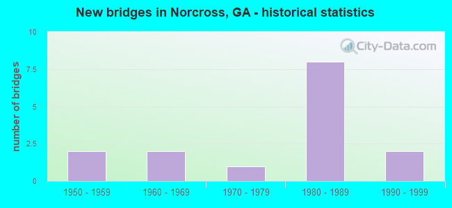
- New bridges - historical statistics
- 21950-1959
- 21960-1969
- 11970-1979
- 81980-1989
- 21990-1999
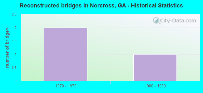
- Reconstructed bridges - Historical Statistics
- 21970-1979
- 11980-1989
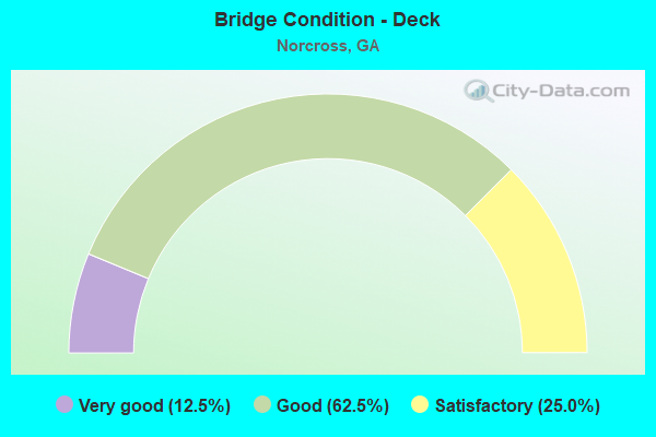
- Bridge Condition - Deck
- 12.5%Very good
- 62.5%Good
- 25.0%Satisfactory
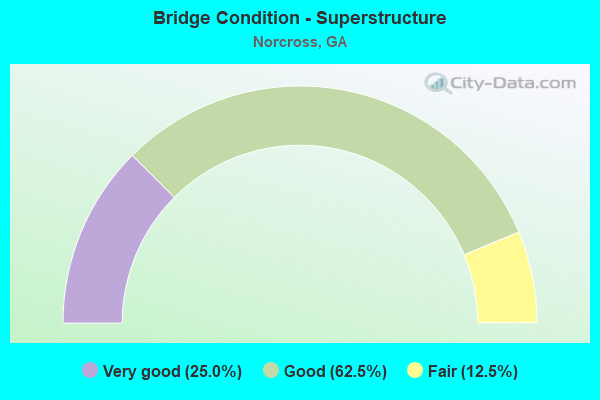
- Bridge Condition - Superstructure
- 25.0%Very good
- 62.5%Good
- 12.5%Fair
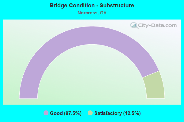
- Bridge Condition - Substructure
- 87.5%Good
- 12.5%Satisfactory
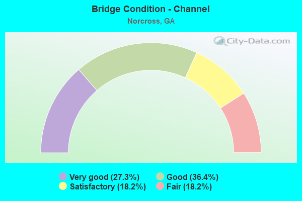
- Bridge Condition - Channel
- 27.3%Very good
- 36.4%Good
- 18.2%Satisfactory
- 18.2%Fair
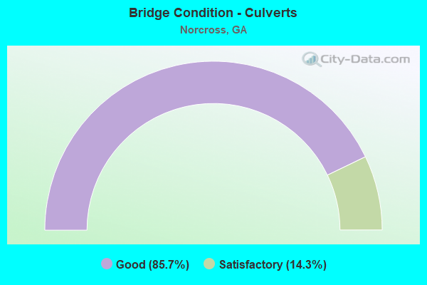
- Bridge Condition - Culverts
- 85.7%Good
- 14.3%Satisfactory
Find on map >> Show street view
Structure Number: 135009, Location: 7 MI N OF AUBURN (Lat: 34.113778, Lng: -83.815150), Route carried "on" structure: County highway 50, Year Built: 1963, Status: Posted for load, Structure Length: 4.85m (15.91ft), Average Daily Traffic: 490 (year 2012), Truck Traffic: 1%, Average Future Daily Traffic: 735 (year 2032), Design Load: H 15, Features Intersected: MULBERRY RIVER, Facility Carried by Structure: LIBERTY CH ROAD
Minimum Vertical Clearance: 30+ m (98+ ft), Kilometerpoint: 0.000, Lanes on structure: 2, Base Highway Network: Yes, Owner: County Highway Agency, Approaching Roadway Width: 6.1m (20.0ft), Material/Design: Steel, Design/Construction: Stringer/Multi-beam, Number Of Spans In Main Unit: 3, Length of Maximum Span: 16.2m (53.1ft), Curb or Sidewalk Widths: Left: 0.6m (2.0ft), Right: 0.6m (2.0ft), Curb-To-Curb Width: 7.3m (24.0ft), Out-to-Out Width: 9.1m (29.9ft)
Condition: Deck: Satisfactory, Superstructure: Fair, Substructure: Satisfactory, Channel: Satisfactory, Operating Rating: 29.0 metric tons, Method Used To Determine Operating Rating: Load Factor (LF), Inventory Rating: 17.2 metric tons, Method Used To Determine Inventory Rating: Load Factor (LF), Structural Evaluation: Somewhat better than minimum adequacy, Deck Geometry: Meets minimum limits, Waterway Adequacy: Superior to present desirable criteria, Approach Roadway Alignment: Equal to present desirable criteria, Bridge Posting: Required (Relationship of Operating Rating to Maximum Legal Load: 0.1 - 9.9% below), Designated Inspection Frequency: Every 24 months, Inspection Date: April 2021, Bridge Improvement Cost: $621,000, Roadway Improvement Cost: $62,000, Total Project Cost: $932,000, Deck Structure Type: Concrete Cast-file-Place
Find on map >> Show street view
Structure Number: 1350035, Location: 2 MI S OF NORCROSS (Lat: 33.912117, Lng: -84.207844), Route carried "on" structure: State highway 140, Year Built: 1973, Year Reconstructed: 1983, Status: Open, Structure Length: 5.33m (17.49ft), Average Daily Traffic: 45,370 (year 2012), Truck Traffic: 1%, Average Future Daily Traffic: 68,055 (year 2032), Design Load: HS 20, Features Intersected: I-85, Facility Carried by Structure: JIMMY CARTER BLVD
Minimum Vertical Clearance: 30+ m (98+ ft), Kilometerpoint: 9.656, Lanes on structure: 7, Lanes under structure: 12, Base Highway Network: Yes, Owner: State Highway Agency, Approaching Roadway Width: 22.6m (74.1ft), Skew: 30 degrees, Material/Design: Steel continuous, Design/Construction: Stringer/Multi-beam, Number Of Spans In Main Unit: 2, Length of Maximum Span: 27.4m (89.9ft), Curb-To-Curb Width: 13.1m (43.0ft), Out-to-Out Width: 27.6m (90.6ft)
Condition: Deck: Satisfactory, Superstructure: Good, Substructure: Good, Operating Rating: 35.3 metric tons, Method Used To Determine Operating Rating: Load Factor (LF), Inventory Rating: 20.8 metric tons, Method Used To Determine Inventory Rating: Load Factor (LF), Structural Evaluation: Somewhat better than minimum adequacy, Deck Geometry: High priority of replacement, Underclear: High priority of corrective action, Approach Roadway Alignment: Equal to present desirable criteria, Designated Inspection Frequency: Every 24 months, Inspection Date: January 2022, Bridge Improvement Cost: $1,616,000, Roadway Improvement Cost: $162,000, Total Project Cost: $2,424,000, Deck Structure Type: Concrete Cast-file-Place
Find on map >> Show street view
Structure Number: 135005, Location: 2 MI SE OF NORCROSS (Lat: 33.925464, Lng: -84.181814), Route carried "on" structure: Interstate 85, Year Built: 1959, Year Reconstructed: 1982, Status: Open, Structure Length: 0.73m (2.40ft), Average Daily Traffic: 276,840 (year 2012), Truck Traffic: 9%, Average Future Daily Traffic: 415,260 (year 2032), Design Load: HS 20+Mod, Features Intersected: BEAVER RUIN CREEK
Minimum Vertical Clearance: 30+ m (98+ ft), Kilometerpoint: 162.544, Lanes on structure: 13, Base Highway Network: Yes, Owner: State Highway Agency, Approaching Roadway Width: 57.0m (187.0ft), Skew: 32 degrees, Material/Design: Concrete, Design/Construction: Culvert, Number Of Spans In Main Unit: 2, Length of Maximum Span: 3.4m (11.2ft)
Condition: Channel: Good, Culverts: Good, Operating Rating: 55.3 metric tons, Method Used To Determine Operating Rating: Field evaluation and documented engineering judgment, Inventory Rating: 32.6 metric tons, Method Used To Determine Inventory Rating: Field evaluation and documented engineering judgment, Structural Evaluation: Better than present minimum criteria, Waterway Adequacy: Equal to present minimum criteria, Approach Roadway Alignment: Equal to present desirable criteria, Designated Inspection Frequency: Every 24 months, Inspection Date: December 2021, Bridge Improvement Cost: $375,000, Roadway Improvement Cost: $38,000, Total Project Cost: $563,000
Find on map >> Show street view
Structure Number: 1350051, Location: 3.4 MI E OF NORCROSS (Lat: 33.944561, Lng: -84.145664), Route carried "on" structure: Interstate 85, Year Built: 1958, Year Reconstructed: 1987, Status: Open, Structure Length: 1.19m (3.90ft), Average Daily Traffic: 283,790 (year 2012), Truck Traffic: 1%, Average Future Daily Traffic: 425,685 (year 2032), Design Load: HS 20+Mod, Features Intersected: BROMOLOW CREEK
Minimum Vertical Clearance: 30+ m (98+ ft), Kilometerpoint: 165.762, Lanes on structure: 14, Base Highway Network: Yes, Owner: State Highway Agency, Approaching Roadway Width: 67.1m (220.1ft), Skew: 33 degrees, Material/Design: Concrete, Design/Construction: Culvert, Number Of Spans In Main Unit: 2, Length of Maximum Span: 3.7m (12.1ft)
Condition: Channel: Good, Culverts: Good, Structural Evaluation: Better than present minimum criteria, Waterway Adequacy: Equal to present desirable criteria, Approach Roadway Alignment: Equal to present desirable criteria, Designated Inspection Frequency: Every 24 months, Inspection Date: December 2021, Bridge Improvement Cost: $651,000, Roadway Improvement Cost: $65,000, Total Project Cost: $977,000
Find on map >> Show street view
Structure Number: 1350079, Location: 2.6 MI E OF NORCROSS (Lat: 33.924269, Lng: -84.173389), Route carried "on" structure: City street 9317, Year Built: 1985, Status: Open, Structure Length: 1.77m (5.81ft), Average Daily Traffic: 38,310 (year 2012), Truck Traffic: 1%, Average Future Daily Traffic: 57,465 (year 2032), Design Load: HS 20+Mod, Features Intersected: BEAVER RUIN CREEK, Facility Carried by Structure: INDIAN TRAIL ROAD
Minimum Vertical Clearance: 30+ m (98+ ft), Kilometerpoint: 14.484, Lanes on structure: 7, Base Highway Network: Yes, Owner: County Highway Agency, Approaching Roadway Width: 26.2m (86.0ft), Material/Design: Prestressed concrete, Design/Construction: Stringer/Multi-beam, Number Of Spans In Main Unit: 1, Length of Maximum Span: 17.7m (58.1ft), Curb-To-Curb Width: 25.2m (82.7ft), Out-to-Out Width: 27.0m (88.6ft)
Condition: Deck: Very good, Superstructure: Very good, Substructure: Good, Channel: Very good, Operating Rating: 56.2 metric tons, Method Used To Determine Operating Rating: Allowable Stress (AS), Inventory Rating: 31.7 metric tons, Method Used To Determine Inventory Rating: Allowable Stress (AS), Structural Evaluation: Better than present minimum criteria, Deck Geometry: High priority of replacement, Waterway Adequacy: Equal to present desirable criteria, Approach Roadway Alignment: Equal to present desirable criteria, Designated Inspection Frequency: Every 24 months, Inspection Date: December 2021, Bridge Improvement Cost: $536,000, Roadway Improvement Cost: $54,000, Total Project Cost: $803,000, Deck Structure Type: Concrete Precast Panels, Wearing Surface/Protective System: Wearing Surface: Bituminous
Find on map >> Show street view
Structure Number: 135008, Location: 2 MI E OF NORCROSS (Lat: 33.928378, Lng: -84.176144), Route carried "on" structure: City street 9317, Year Built: 1983, Status: Open, Structure Length: 8.02m (26.31ft), Average Daily Traffic: 33,770 (year 2012), Truck Traffic: 1%, Average Future Daily Traffic: 50,655 (year 2032), Design Load: HS 20+Mod, Features Intersected: I-85- M-9317 RAMP, Facility Carried by Structure: INDIAN TRAIL ROAD
Minimum Vertical Clearance: 30+ m (98+ ft), Kilometerpoint: 14.484, Lanes on structure: 6, Lanes under structure: 13, Owner: State Highway Agency, Approaching Roadway Width: 45.7m (149.9ft), Skew: 20 degrees, Material/Design: Steel continuous, Design/Construction: Stringer/Multi-beam, Number Of Spans In Main Unit: 2, Length of Maximum Span: 43.0m (141.1ft), Curb or Sidewalk Widths: Left: 1.8m (5.9ft), Right: 1.8m (5.9ft), Curb-To-Curb Width: 23.1m (75.8ft), Out-to-Out Width: 28.8m (94.5ft)
Condition: Deck: Good, Superstructure: Good, Substructure: Good, Operating Rating: 50.8 metric tons, Method Used To Determine Operating Rating: Load Factor (LF), Inventory Rating: 30.8 metric tons, Method Used To Determine Inventory Rating: Load Factor (LF), Structural Evaluation: Better than present minimum criteria, Deck Geometry: Meets minimum limits, Underclear: Somewhat better than minimum adequacy, Approach Roadway Alignment: Equal to present desirable criteria, Designated Inspection Frequency: Every 24 months, Inspection Date: January 2022, Bridge Improvement Cost: $2,149,000, Roadway Improvement Cost: $215,000, Total Project Cost: $3,223,000, Deck Structure Type: Concrete Cast-file-Place
Find on map >> Show street view
Structure Number: 1350104, Location: 1.8 MI S OF NORCROSS (Lat: 33.918247, Lng: -84.197264), Route carried "on" structure: County highway 2860, Year Built: 1987, Status: Open, Structure Length: 6.28m (20.60ft), Average Daily Traffic: 1,930 (year 2012), Truck Traffic: 1%, Average Future Daily Traffic: 2,895 (year 2032), Design Load: HS 20+Mod, Features Intersected: I-85, Facility Carried by Structure: CENTER WAY
Minimum Vertical Clearance: 30+ m (98+ ft), Kilometerpoint: 0.000, Lanes on structure: 4, Lanes under structure: 13, Owner: State Highway Agency, Approaching Roadway Width: 15.8m (51.8ft), Skew: 1 degrees, Material/Design: Prestressed concrete, Design/Construction: Stringer/Multi-beam, Number Of Spans In Main Unit: 2, Length of Maximum Span: 31.4m (103.0ft), Curb or Sidewalk Widths: Left: 1.8m (5.9ft), Right: 1.8m (5.9ft), Curb-To-Curb Width: 15.8m (51.8ft), Out-to-Out Width: 20.3m (66.6ft)
Condition: Deck: Good, Superstructure: Good, Substructure: Good, Operating Rating: 61.6 metric tons, Method Used To Determine Operating Rating: Load Factor (LF), Inventory Rating: 19.0 metric tons, Method Used To Determine Inventory Rating: Load Factor (LF), Structural Evaluation: Somewhat better than minimum adequacy, Deck Geometry: Meets minimum limits, Underclear: High priority of corrective action, Approach Roadway Alignment: Equal to present minimum criteria, Designated Inspection Frequency: Every 24 months, Inspection Date: January 2022, Bridge Improvement Cost: $1,244,000, Roadway Improvement Cost: $124,000, Total Project Cost: $1,866,000, Deck Structure Type: Concrete Cast-file-Place
Find on map >> Show street view
Structure Number: 1350106, Location: 2.8 MI N OF NORCROSS (Lat: 33.936344, Lng: -84.159369), Route carried "on" structure: State highway 378, Year Built: 1987, Status: Open, Structure Length: 6.28m (20.60ft), Average Daily Traffic: 33,010 (year 2012), Truck Traffic: 1%, Average Future Daily Traffic: 49,515 (year 2032), Design Load: HS 20+Mod, Features Intersected: I-85, Facility Carried by Structure: BEAVER RUIN ROAD
Minimum Vertical Clearance: 30+ m (98+ ft), Kilometerpoint: 4.828, Lanes on structure: 7, Lanes under structure: 12, Owner: State Highway Agency, Approaching Roadway Width: 8.5m (27.9ft), Material/Design: Prestressed concrete, Design/Construction: Stringer/Multi-beam, Number Of Spans In Main Unit: 2, Length of Maximum Span: 31.4m (103.0ft), Curb or Sidewalk Widths: Left: 1.8m (5.9ft), Right: 1.8m (5.9ft), Curb-To-Curb Width: 26.7m (87.6ft), Out-to-Out Width: 31.1m (102.0ft)
Condition: Deck: Good, Superstructure: Good, Substructure: Good, Operating Rating: 46.2 metric tons, Method Used To Determine Operating Rating: Allowable Stress (AS), Inventory Rating: 32.6 metric tons, Method Used To Determine Inventory Rating: Allowable Stress (AS), Structural Evaluation: Better than present minimum criteria, Deck Geometry: Meets minimum limits, Underclear: Equal to present minimum criteria, Approach Roadway Alignment: Equal to present desirable criteria, Designated Inspection Frequency: Every 24 months, Inspection Date: January 2022, Bridge Improvement Cost: $1,902,000, Roadway Improvement Cost: $190,000, Total Project Cost: $2,854,000, Deck Structure Type: Concrete Cast-file-Place
Find on map >> Show street view
Structure Number: 1350113, Location: 2 MI W OF NORCROSS (Lat: 33.946550, Lng: -84.235331), Route carried "on" structure: County highway 2947, Year Built: 1980, Status: Open, Structure Length: 0.70m (2.30ft), Average Daily Traffic: 51,140 (year 2012), Truck Traffic: 1%, Average Future Daily Traffic: 76,710 (year 2032), Design Load: HS 20+Mod, Features Intersected: CROOKED CREEK TRIB, Facility Carried by Structure: PEACHTREE IND BLVD
Minimum Vertical Clearance: 30+ m (98+ ft), Kilometerpoint: 3.219, Lanes on structure: 2, Base Highway Network: Yes, Owner: County Highway Agency, Approaching Roadway Width: 11.6m (38.1ft), Skew: 13 degrees, Material/Design: Concrete, Design/Construction: Culvert, Number Of Spans In Main Unit: 2, Length of Maximum Span: 3.4m (11.2ft)
Condition: Channel: Fair, Culverts: Good, Operating Rating: 42.6 metric tons, Method Used To Determine Operating Rating: Load Factor (LF), Inventory Rating: 25.4 metric tons, Method Used To Determine Inventory Rating: Load Factor (LF), Structural Evaluation: Equal to present minimum criteria, Waterway Adequacy: Equal to present desirable criteria, Approach Roadway Alignment: Equal to present minimum criteria, Designated Inspection Frequency: Every 24 months, Inspection Date: January 2022, Bridge Improvement Cost: $90,000, Roadway Improvement Cost: $9,000, Total Project Cost: $135,000
Find on map >> Show street view
Structure Number: 1355078, Location: 2.6 MI E OF NORCROSS (Lat: 33.941819, Lng: -84.168964), Route carried "on" structure: County highway 607, Year Built: 1990, Status: Open, Structure Length: 1.34m (4.40ft), Average Daily Traffic: 7,490 (year 2012), Truck Traffic: 1%, Average Future Daily Traffic: 11,235 (year 2032), Design Load: HS 20+Mod, Features Intersected: SHELLY CREEK TRIB, Facility Carried by Structure: POND ROAD
Minimum Vertical Clearance: 30+ m (98+ ft), Kilometerpoint: 0.000, Lanes on structure: 2, Base Highway Network: Yes, Owner: County Highway Agency, Approaching Roadway Width: 7.0m (23.0ft), Material/Design: Concrete, Design/Construction: Culvert, Number Of Spans In Main Unit: 4, Length of Maximum Span: 3.0m (9.8ft)
Condition: Channel: Good, Culverts: Good, Operating Rating: 55.3 metric tons, Method Used To Determine Operating Rating: Field evaluation and documented engineering judgment, Inventory Rating: 32.6 metric tons, Method Used To Determine Inventory Rating: Field evaluation and documented engineering judgment, Structural Evaluation: Better than present minimum criteria, Waterway Adequacy: Superior to present desirable criteria, Approach Roadway Alignment: Equal to present desirable criteria, Designated Inspection Frequency: Every 24 months, Inspection Date: December 2021, Bridge Improvement Cost: $172,000, Roadway Improvement Cost: $17,000, Total Project Cost: $258,000
Find on map >> Show street view
Structure Number: 1355079, Location: 2 MI E OF NORCROSS (Lat: 33.943008, Lng: -84.174689), Route carried "on" structure: County highway 608, Year Built: 1962, Status: Open, Structure Length: 1.40m (4.59ft), Average Daily Traffic: 1,930 (year 2012), Truck Traffic: 1%, Average Future Daily Traffic: 2,895 (year 2032), Design Load: H 15, Features Intersected: SHELLY CREEK TRIB, Facility Carried by Structure: INGRAM ROAD
Minimum Vertical Clearance: 30+ m (98+ ft), Kilometerpoint: 0.000, Lanes on structure: 2, Base Highway Network: Yes, Owner: County Highway Agency, Approaching Roadway Width: 8.5m (27.9ft), Material/Design: Concrete, Design/Construction: Slab, Number Of Spans In Main Unit: 2, Length of Maximum Span: 7.6m (24.9ft), Curb-To-Curb Width: 8.0m (26.2ft), Out-to-Out Width: 9.0m (29.5ft)
Condition: Deck: Good, Superstructure: Good, Substructure: Good, Channel: Fair, Operating Rating: 31.7 metric tons, Method Used To Determine Operating Rating: Allowable Stress (AS), Inventory Rating: 19.9 metric tons, Method Used To Determine Inventory Rating: Allowable Stress (AS), Structural Evaluation: Somewhat better than minimum adequacy, Deck Geometry: Meets minimum limits, Waterway Adequacy: Equal to present minimum criteria, Approach Roadway Alignment: Equal to present minimum criteria, Length Of Structure Improvement: 41.64m (136.61ft), Designated Inspection Frequency: Every 24 months, Inspection Date: December 2021, Bridge Improvement Cost: $180,000, Roadway Improvement Cost: $18,000, Total Project Cost: $270,000, Deck Structure Type: Concrete Precast Panels, Wearing Surface/Protective System: Wearing Surface: Bituminous
Find on map >> Show street view
Structure Number: 1355092, Location: 2 MI SE OF NORCROSS (Lat: 33.927439, Lng: -84.183889), Route carried "on" structure: County highway 1911, Year Built: 1991, Status: Open, Structure Length: 2.13m (6.99ft), Average Daily Traffic: 1,930 (year 2012), Truck Traffic: 1%, Average Future Daily Traffic: 2,895 (year 2032), Design Load: HS 20+Mod, Features Intersected: BEAVER RUIN CREEK, Facility Carried by Structure: BROOK HOLLOW PKWY
Minimum Vertical Clearance: 30+ m (98+ ft), Kilometerpoint: 0.000, Lanes on structure: 5, Base Highway Network: Yes, Owner: County Highway Agency, Approaching Roadway Width: 19.8m (65.0ft), Material/Design: Prestressed concrete, Design/Construction: Stringer/Multi-beam, Number Of Spans In Main Unit: 1, Length of Maximum Span: 21.3m (69.9ft), Curb-To-Curb Width: 20.1m (65.9ft), Out-to-Out Width: 21.3m (69.9ft)
Condition: Deck: Good, Superstructure: Very good, Substructure: Good, Channel: Very good, Operating Rating: 45.3 metric tons, Method Used To Determine Operating Rating: Allowable Stress (AS), Inventory Rating: 32.6 metric tons, Method Used To Determine Inventory Rating: Allowable Stress (AS), Structural Evaluation: Better than present minimum criteria, Deck Geometry: Somewhat better than minimum adequacy, Waterway Adequacy: Equal to present desirable criteria, Approach Roadway Alignment: Equal to present desirable criteria, Designated Inspection Frequency: Every 24 months, Inspection Date: December 2021, Bridge Improvement Cost: $497,000, Roadway Improvement Cost: $50,000, Total Project Cost: $746,000, Deck Structure Type: Concrete Cast-file-Place
Find on map >> Show street view
Structure Number: 1355097, Location: 3.5 MI N OF LILBURN (Lat: 33.942928, Lng: -84.142650), Route carried "on" structure: City street 9417, Year Built: 1984, Status: Open, Structure Length: 1.34m (4.40ft), Average Daily Traffic: 1,930 (year 2012), Truck Traffic: 1%, Average Future Daily Traffic: 2,895 (year 2032), Design Load: HS 20+Mod, Features Intersected: BROMOLOW CREEK, Facility Carried by Structure: SHACKELFORD ROAD
Minimum Vertical Clearance: 30+ m (98+ ft), Kilometerpoint: 1.609, Lanes on structure: 3, Base Highway Network: Yes, Owner: County Highway Agency, Approaching Roadway Width: 11.9m (39.0ft), Material/Design: Concrete, Design/Construction: Culvert, Number Of Spans In Main Unit: 4, Length of Maximum Span: 3.0m (9.8ft)
Condition: Channel: Good, Culverts: Good, Operating Rating: 55.3 metric tons, Method Used To Determine Operating Rating: Field evaluation and documented engineering judgment, Inventory Rating: 32.6 metric tons, Method Used To Determine Inventory Rating: Field evaluation and documented engineering judgment, Structural Evaluation: Better than present minimum criteria, Waterway Adequacy: Better than present minimum criteria, Approach Roadway Alignment: Equal to present desirable criteria, Designated Inspection Frequency: Every 24 months, Inspection Date: December 2021, Bridge Improvement Cost: $219,000, Roadway Improvement Cost: $22,000, Total Project Cost: $328,000
Find on map >> Show street view
Structure Number: 1355123, Location: 3.5 MI N OF LILBURN (Lat: 33.937328, Lng: -84.136672), Route carried "on" structure: County highway 557, Year Built: 1988, Status: Open, Structure Length: 1.34m (4.40ft), Average Daily Traffic: 38,420 (year 2012), Truck Traffic: 1%, Average Future Daily Traffic: 57,630 (year 2032), Design Load: HS 20+Mod, Features Intersected: BROMOLOW CREEK, Facility Carried by Structure: STEVE REYNOLDS BVD
Minimum Vertical Clearance: 30+ m (98+ ft), Kilometerpoint: 3.219, Lanes on structure: 4, Base Highway Network: Yes, Owner: County Highway Agency, Approaching Roadway Width: 19.5m (64.0ft), Material/Design: Concrete, Design/Construction: Culvert, Number Of Spans In Main Unit: 4, Length of Maximum Span: 3.0m (9.8ft)
Condition: Channel: Very good, Culverts: Satisfactory, Operating Rating: 55.3 metric tons, Method Used To Determine Operating Rating: Field evaluation and documented engineering judgment, Inventory Rating: 32.6 metric tons, Method Used To Determine Inventory Rating: Field evaluation and documented engineering judgment, Structural Evaluation: Equal to present minimum criteria, Waterway Adequacy: Equal to present desirable criteria, Approach Roadway Alignment: Better than present minimum criteria, Designated Inspection Frequency: Every 24 months, Underwater Inspection Frequency: Every 60 months, Inspection Date: December 2021, Underwater Inspection Date: April 2019, Bridge Improvement Cost: $266,000, Roadway Improvement Cost: $27,000, Total Project Cost: $399,000
Find on map >> Show street view
Structure Number: 1355127, Location: 2.3 MI E OF NORCROSS (Lat: 33.940931, Lng: -84.165236), Route carried "on" structure: County highway 923, Year Built: 1985, Status: Open, Structure Length: 0.64m (2.10ft), Average Daily Traffic: 16,700 (year 2012), Truck Traffic: 1%, Average Future Daily Traffic: 25,050 (year 2032), Design Load: HS 20+Mod, Features Intersected: BROMOLOW CREEK TRIB, Facility Carried by Structure: SATELLITE BLVD.
Minimum Vertical Clearance: 30+ m (98+ ft), Kilometerpoint: 3.219, Lanes on structure: 5, Base Highway Network: Yes, Owner: County Highway Agency, Approaching Roadway Width: 20.1m (65.9ft), Material/Design: Concrete, Design/Construction: Culvert, Number Of Spans In Main Unit: 2, Length of Maximum Span: 3.0m (9.8ft), Curb or Sidewalk Widths: Left: 0.2m (0.7ft), Right: 1.2m (3.9ft)
Condition: Channel: Satisfactory, Culverts: Good, Structural Evaluation: Better than present minimum criteria, Waterway Adequacy: Superior to present desirable criteria, Approach Roadway Alignment: Equal to present desirable criteria, Designated Inspection Frequency: Every 24 months, Inspection Date: December 2021, Bridge Improvement Cost: $149,000, Roadway Improvement Cost: $15,000, Total Project Cost: $224,000
Find on map >> Show street view
Structure Number: 1350035, Location: 2 MI S OF NORCROSS (Lat: 33.912117, Lng: -84.207844), Route carried "under" structure: Interstate 85, Structure Length: 0. m, Average Daily Traffic: 261,500 (year 1998), Truck Traffic: 1%, Features Intersected: SR 140 JIMMY CARTER BLVD, Facility Carried by Structure: JIMMY CARTER BLVD
Minimum Vertical Clearance: 6.04m (19.82ft), Kilometerpoint: 159.325, Lanes on structure: 7, Length of Maximum Span: 0.0m
Find on map >> Show street view
Structure Number: 135008, Location: 2 MI E OF NORCROSS (Lat: 33.928378, Lng: -84.176144), Route carried "under" structure: Interstate 85, Structure Length: 0. m, Average Daily Traffic: 260,000 (year 1998), Truck Traffic: 1%, Features Intersected: M-9317 INDIAN TRAIL ROAD, Facility Carried by Structure: INDIAN TRAIL ROAD
Minimum Vertical Clearance: 5.33m (17.49ft), Kilometerpoint: 162.544, Lanes on structure: 6, Length of Maximum Span: 0.0m
Find on map >> Show street view
Structure Number: 135008, Location: 2 MI E OF NORCROSS (Lat: 33.928378, Lng: -84.176144), Route carried "under" structure: Ramp City street 9317, Structure Length: 0. m, Average Daily Traffic: 500 (year 2009), Truck Traffic: 1%, Features Intersected: M-9317 INDIAN TRAIL ROAD, Facility Carried by Structure: INDIAN TRAIL ROAD
Minimum Vertical Clearance: 5.08m (16.67ft), Kilometerpoint: 14.484, Lanes on structure: 6, Length of Maximum Span: 0.0m
Find on map >> Show street view
Structure Number: 1350094, Location: IN NORCROSS (Lat: 33.934106, Lng: -84.223414), Route carried "under" structure: State highway 140, Structure Length: 0. m, Average Daily Traffic: 36,850 (year 2012), Truck Traffic: 1%, Features Intersected: JIMMY CARTER BLVD, Facility Carried by Structure: NOR SOUTHERN RAILR
Minimum Vertical Clearance: 6.07m (19.91ft), Kilometerpoint: 6.437, Length of Maximum Span: 0.0m
Find on map >> Show street view
Structure Number: 1350104, Location: 1.8 MI S OF NORCROSS (Lat: 33.918247, Lng: -84.197264), Route carried "under" structure: Interstate 85, Structure Length: 0. m, Average Daily Traffic: 261,500 (year 1998), Truck Traffic: 1%, Features Intersected: CR 2860 CENTER WAY, Facility Carried by Structure: CENTER WAY
Minimum Vertical Clearance: 5.43m (17.81ft), Kilometerpoint: 159.325, Lanes on structure: 4, Length of Maximum Span: 0.0m
Find on map >> Show street view
Structure Number: 1350106, Location: 2.8 MI N OF NORCROSS (Lat: 33.936344, Lng: -84.159369), Route carried "under" structure: Interstate 85, Structure Length: 0. m, Average Daily Traffic: 256,000 (year 1998), Truck Traffic: 1%, Features Intersected: SR 378 BEAVER RUIN ROAD, Facility Carried by Structure: BEAVER RUIN ROAD
Minimum Vertical Clearance: 5.35m (17.55ft), Kilometerpoint: 164.153, Lanes on structure: 7, Length of Maximum Span: 0.0m