Bridge Statistics for Normangee, Texas (TX)
Condition, Traffic, Stress, Structural Evaluation, Project Costs
- National Bridge Inventory (NBI) Statistics
- 13Number of bridges
- 79ft / 24.0mTotal length
- $1,000Total costs
- 17,049Total average daily traffic
- 3,273Total average daily truck traffic
- 28,013Total future (year 2033) average daily traffic
- National Bridge Inventory (NBI) Registered Bridges for Normangee
- No street view available for this location
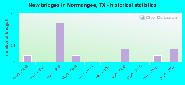
- New bridges - historical statistics
- 11930-1939
- 61950-1959
- 11960-1969
- 21990-1999
- 12010-2019
- 22020-2022


- Bridge Condition - Deck
- 25.0%Very good
- 62.5%Good
- 12.5%Satisfactory

- Bridge Condition - Superstructure
- 37.5%Very good
- 37.5%Good
- 25.0%Satisfactory

- Bridge Condition - Substructure
- 37.5%Very good
- 25.0%Good
- 25.0%Satisfactory
- 12.5%Fair

- Bridge Condition - Channel
- 15.4%Very good
- 30.8%Good
- 46.2%Satisfactory
- 7.7%Fair

- Bridge Condition - Culverts
- 60.0%Satisfactory
- 40.0%Fair
Find on map >> Show street view
Structure Number: 171450055201015, Location: 1.8 MI W OF FM 39 (Lat: 31.025819, Lng: -96.143300), Route carried "on" structure: State highway 3, Year Built: 1954, Status: Open, Structure Length: 1.83m (6.00ft), Average Daily Traffic: 1,828 (year 2020), Truck Traffic: 10%, Average Future Daily Traffic: 2,070 (year 2033), Features Intersected: CARRYALL CREEK
Minimum Vertical Clearance: 30+ m (98+ ft), Kilometerpoint: 19.891, Lanes on structure: 2, Owner: State Highway Agency, Approaching Roadway Width: 7.3m (24.0ft), Material/Design: Concrete, Design/Construction: Stringer/Multi-beam, Number Of Spans In Main Unit: 2, Length of Maximum Span: 9.1m (29.9ft), Curb-To-Curb Width: 7.3m (24.0ft), Out-to-Out Width: 7.5m (24.6ft)
Condition: Deck: Good, Superstructure: Good, Substructure: Fair, Channel: Good, Operating Rating: 40.8 metric tons, Method Used To Determine Operating Rating: Load Factor (LF), Inventory Rating: 24.5 metric tons, Method Used To Determine Inventory Rating: Load Factor (LF), Structural Evaluation: Somewhat better than minimum adequacy, Deck Geometry: Meets minimum limits, Waterway Adequacy: Equal to present minimum criteria, Approach Roadway Alignment: Equal to present desirable criteria, Designated Inspection Frequency: Every 24 months, Inspection Date: Febuary 2021, Deck Structure Type: Concrete Cast-file-Place
Find on map >> Show street view
Structure Number: 171450064301001, Location: 0.45 MI N OF FM 3 (Lat: 31.036019, Lng: -96.114706), Route carried "on" structure: State highway 39, Year Built: 1939, Status: Open, Structure Length: 1.71m (5.61ft), Average Daily Traffic: 2,193 (year 2020), Truck Traffic: 16%, Average Future Daily Traffic: 3,370 (year 2033), Design Load: H 15, Features Intersected: CANEY CREEK
Minimum Vertical Clearance: 30+ m (98+ ft), Kilometerpoint: 63.181, Lanes on structure: 2, Owner: State Highway Agency, Approaching Roadway Width: 9.1m (29.9ft), Skew: 4 degrees, Material/Design: Concrete, Design/Construction: Culvert, Number Of Spans In Main Unit: 5, Length of Maximum Span: 2.1m (6.9ft), Curb-To-Curb Width: 9.1m (29.9ft), Out-to-Out Width: 13.2m (43.3ft)
Condition: Channel: Satisfactory, Culverts: Fair, Operating Rating: 39.9 metric tons, Method Used To Determine Operating Rating: Load Factor (LF), Inventory Rating: 23.6 metric tons, Method Used To Determine Inventory Rating: Load Factor (LF), Structural Evaluation: Somewhat better than minimum adequacy, Deck Geometry: Meets minimum limits, Waterway Adequacy: Equal to present minimum criteria, Approach Roadway Alignment: Equal to present desirable criteria, Designated Inspection Frequency: Every 24 months, Inspection Date: Febuary 2021, Deck Structure Type: Concrete Cast-file-Place, Wearing Surface/Protective System: Wearing Surface: Bituminous
Find on map >> Show street view
Structure Number: 171450AA0324001, Location: 1.3 MI N OF FM 3 (Lat: 31.043181, Lng: -96.145700), Route carried "on" structure: County highway 459, Year Built: 1990, Status: Open, Structure Length: 0.91m (2.99ft), Average Daily Traffic: 30 (year 2016), Average Future Daily Traffic: 40 (year 2038), Features Intersected: CARRYALL CREEK
Minimum Vertical Clearance: 30+ m (98+ ft), Kilometerpoint: 2.086, Lanes on structure: 1, Owner: County Highway Agency, Approaching Roadway Width: 5.5m (18.0ft), Material/Design: Steel continuous, Design/Construction: Stringer/Multi-beam, Number Of Spans In Main Unit: 2, Length of Maximum Span: 7.0m (23.0ft), Curb-To-Curb Width: 5.0m (16.4ft), Out-to-Out Width: 5.0m (16.4ft)
Condition: Deck: Satisfactory, Superstructure: Satisfactory, Substructure: Satisfactory, Channel: Satisfactory, Operating Rating: 49.0 metric tons, Method Used To Determine Operating Rating: Allowable Stress (AS), Inventory Rating: 38.1 metric tons, Method Used To Determine Inventory Rating: Allowable Stress (AS), Structural Evaluation: Equal to present minimum criteria, Deck Geometry: High priority of corrective action, Waterway Adequacy: Better than present minimum criteria, Approach Roadway Alignment: Equal to present minimum criteria, Length Of Structure Improvement: 0.91m (2.99ft), Designated Inspection Frequency: Every 24 months, Critical Feature Inspection Frequency: Every 24 months, Inspection Date: January 2020, Critical Feature Inspection Date: December 2020, Bridge Improvement Cost: $1,000, Total Project Cost: $1,000, Deck Structure Type: Wood or Timber, Wearing Surface/Protective System: Wearing Surface: Wood or Timber
Find on map >> Show street view
Structure Number: 171540047503058, Location: 0.35 MI NE OF FM 39 (Lat: 31.030206, Lng: -96.109642), Route carried "on" structure: State highway 999, Year Built: 1954, Year Reconstructed: 2008, Status: Open, Structure Length: 1.83m (6.00ft), Average Daily Traffic: 3,350 (year 2019), Truck Traffic: 43%, Average Future Daily Traffic: 4,290 (year 2033), Design Load: H 15, Features Intersected: CANEY CREEK, Facility Carried by Structure: OSR
Minimum Vertical Clearance: 30+ m (98+ ft), Kilometerpoint: 14.326, Lanes on structure: 2, Owner: State Highway Agency, Approaching Roadway Width: 12.8m (42.0ft), Material/Design: Concrete, Design/Construction: Stringer/Multi-beam, Number Of Spans In Main Unit: 2, Length of Maximum Span: 9.1m (29.9ft), Curb-To-Curb Width: 12.6m (41.3ft), Out-to-Out Width: 13.4m (44.0ft)
Condition: Deck: Good, Superstructure: Good, Substructure: Satisfactory, Channel: Fair, Operating Rating: 44.4 metric tons, Method Used To Determine Operating Rating: Load Factor (LF), Inventory Rating: 31.7 metric tons, Method Used To Determine Inventory Rating: Load Factor (LF), Structural Evaluation: Equal to present minimum criteria, Deck Geometry: Equal to present minimum criteria, Waterway Adequacy: Equal to present minimum criteria, Approach Roadway Alignment: Equal to present desirable criteria, Designated Inspection Frequency: Every 24 months, Inspection Date: June 2021, Deck Structure Type: Concrete Cast-file-Place, Wearing Surface/Protective System: Wearing Surface: Bituminous
Find on map >> Show street view
Structure Number: 171540047503072, Location: 1.55 MI NE OF FM 39 (Lat: 31.039822, Lng: -96.093017), Route carried "on" structure: State highway 999, Year Built: 1958, Year Reconstructed: 2008, Status: Open, Structure Length: 2.74m (8.99ft), Average Daily Traffic: 1,559 (year 2020), Truck Traffic: 13%, Average Future Daily Traffic: 3,171 (year 2039), Features Intersected: COBBS BRANCH, Facility Carried by Structure: OSR
Minimum Vertical Clearance: 30+ m (98+ ft), Kilometerpoint: 16.253, Lanes on structure: 2, Owner: State Highway Agency, Approaching Roadway Width: 12.8m (42.0ft), Material/Design: Concrete, Design/Construction: Stringer/Multi-beam, Number Of Spans In Main Unit: 3, Length of Maximum Span: 9.1m (29.9ft), Curb-To-Curb Width: 12.6m (41.3ft), Out-to-Out Width: 13.4m (44.0ft)
Condition: Deck: Good, Superstructure: Satisfactory, Substructure: Good, Channel: Good, Operating Rating: 44.4 metric tons, Method Used To Determine Operating Rating: Load Factor (LF), Inventory Rating: 31.7 metric tons, Method Used To Determine Inventory Rating: Load Factor (LF), Structural Evaluation: Equal to present minimum criteria, Deck Geometry: Better than present minimum criteria, Waterway Adequacy: Equal to present minimum criteria, Approach Roadway Alignment: Equal to present desirable criteria, Designated Inspection Frequency: Every 24 months, Inspection Date: June 2021, Deck Structure Type: Concrete Cast-file-Place, Wearing Surface/Protective System: Wearing Surface: Bituminous
Find on map >> Show street view
Structure Number: 171540047503073, Location: 1.1 MI NE OF FM 2289 (Lat: 31.051008, Lng: -96.072642), Route carried "on" structure: State highway 999, Year Built: 1958, Status: Open, Structure Length: 0.64m (2.10ft), Average Daily Traffic: 1,273 (year 2020), Truck Traffic: 14%, Average Future Daily Traffic: 2,546 (year 2039), Features Intersected: SALT BRANCH SLOUGH, Facility Carried by Structure: OSR
Minimum Vertical Clearance: 30+ m (98+ ft), Kilometerpoint: 18.575, Lanes on structure: 2, Owner: State Highway Agency, Approaching Roadway Width: 7.3m (24.0ft), Material/Design: Concrete, Design/Construction: Culvert, Number Of Spans In Main Unit: 2, Length of Maximum Span: 3.0m (9.8ft)
Condition: Channel: Good, Culverts: Satisfactory, Operating Rating: 39.9 metric tons, Method Used To Determine Operating Rating: Load Factor (LF), Inventory Rating: 23.6 metric tons, Method Used To Determine Inventory Rating: Load Factor (LF), Structural Evaluation: Equal to present minimum criteria, Waterway Adequacy: Equal to present minimum criteria, Approach Roadway Alignment: Equal to present desirable criteria, Designated Inspection Frequency: Every 24 months, Inspection Date: June 2021
Find on map >> Show street view
Structure Number: 171540047503074, Location: 1.3 MI NE OF FM 2289 (Lat: 31.053153, Lng: -96.069539), Route carried "on" structure: State highway 999, Year Built: 1958, Status: Open, Structure Length: 0.64m (2.10ft), Average Daily Traffic: 1,273 (year 2020), Truck Traffic: 18%, Average Future Daily Traffic: 2,660 (year 2033), Features Intersected: SALT CREEK, Facility Carried by Structure: OSR
Minimum Vertical Clearance: 30+ m (98+ ft), Kilometerpoint: 18.952, Lanes on structure: 2, Owner: State Highway Agency, Approaching Roadway Width: 7.3m (24.0ft), Material/Design: Concrete, Design/Construction: Culvert, Number Of Spans In Main Unit: 2, Length of Maximum Span: 3.0m (9.8ft)
Condition: Channel: Satisfactory, Culverts: Fair, Operating Rating: 39.9 metric tons, Method Used To Determine Operating Rating: Load Factor (LF), Inventory Rating: 23.6 metric tons, Method Used To Determine Inventory Rating: Load Factor (LF), Structural Evaluation: Somewhat better than minimum adequacy, Waterway Adequacy: Equal to present minimum criteria, Approach Roadway Alignment: Equal to present desirable criteria, Designated Inspection Frequency: Every 24 months, Inspection Date: June 2021
Find on map >> Show street view
Structure Number: 171540047503098, Location: 0.65 MI NE OF FM 39 (Lat: 31.032231, Lng: -96.106531), Route carried "on" structure: State highway 999, Year Built: 1990, Status: Open, Structure Length: 1.55m (5.09ft), Average Daily Traffic: 1,559 (year 2020), Truck Traffic: 13%, Average Future Daily Traffic: 3,171 (year 2039), Design Load: HS 20, Features Intersected: CANEY CREEK RELIEF, Facility Carried by Structure: OSR
Minimum Vertical Clearance: 30+ m (98+ ft), Kilometerpoint: 14.709, Lanes on structure: 2, Owner: State Highway Agency, Approaching Roadway Width: 7.3m (24.0ft), Material/Design: Concrete, Design/Construction: Culvert, Number Of Spans In Main Unit: 6, Length of Maximum Span: 2.4m (7.9ft), Curb-To-Curb Width: 11.0m (36.1ft), Out-to-Out Width: 18.2m (59.7ft)
Condition: Channel: Satisfactory, Culverts: Satisfactory, Operating Rating: 39.9 metric tons, Method Used To Determine Operating Rating: Load Factor (LF), Inventory Rating: 23.6 metric tons, Method Used To Determine Inventory Rating: Load Factor (LF), Structural Evaluation: Equal to present minimum criteria, Deck Geometry: Equal to present minimum criteria, Waterway Adequacy: Equal to present minimum criteria, Approach Roadway Alignment: Equal to present desirable criteria, Designated Inspection Frequency: Every 48 months, Inspection Date: June 2021, Deck Structure Type: Concrete Cast-file-Place, Wearing Surface/Protective System: Wearing Surface: Bituminous
Find on map >> Show street view
Structure Number: 171540047503136, Location: 3.9 MI NE OF FM 1452 (Lat: 31.006811, Lng: -96.149817), Route carried "on" structure: State highway 999, Year Built: 2020, Status: Open, Structure Length: 3.66m (12.01ft), Average Daily Traffic: 1,041 (year 2018), Truck Traffic: 14%, Average Future Daily Traffic: 1,920 (year 2033), Design Load: HL 93, Features Intersected: BRANCH OF CARRYALL CK, Facility Carried by Structure: OSR
Minimum Vertical Clearance: 30+ m (98+ ft), Kilometerpoint: 9.674, Lanes on structure: 1, Owner: State Highway Agency, Approaching Roadway Width: 3.4m (11.2ft), Material/Design: Prestressed concrete, Design/Construction: Stringer/Multi-beam, Number Of Spans In Main Unit: 1, Length of Maximum Span: 36.6m (120.1ft), Curb-To-Curb Width: 3.4m (11.2ft), Out-to-Out Width: 11.0m (36.1ft)
Condition: Deck: Very good, Superstructure: Very good, Substructure: Very good, Channel: Very good, Operating Rating: 44.4 metric tons, Method Used To Determine Operating Rating: Assigned ratings based on Load and Resistance Factor Design (LRFD) reported in metric tons, Inventory Rating: 32.7 metric tons, Method Used To Determine Inventory Rating: Allowable Stress (AS), Structural Evaluation: Equal to present desirable criteria, Deck Geometry: High priority of replacement, Waterway Adequacy: Superior to present desirable criteria, Approach Roadway Alignment: Equal to present desirable criteria, Designated Inspection Frequency: Every 24 months, Inspection Date: March 2020, Deck Structure Type: Concrete Cast-file-Place
Find on map >> Show street view
Structure Number: 171540047503138, Location: 2.95 MI NE OF FM 1452 (Lat: 30.999253, Lng: -96.162781), Route carried "on" structure: State highway 999, Year Built: 2020, Status: Open, Structure Length: 2.29m (7.51ft), Average Daily Traffic: 1,041 (year 2018), Truck Traffic: 14%, Average Future Daily Traffic: 1,920 (year 2033), Design Load: HL 93, Features Intersected: RED BANK CREEK, Facility Carried by Structure: OSR
Minimum Vertical Clearance: 30+ m (98+ ft), Kilometerpoint: 8.166, Lanes on structure: 2, Owner: State Highway Agency, Approaching Roadway Width: 10.0m (32.8ft), Material/Design: Prestressed concrete, Design/Construction: Slab, Number Of Spans In Main Unit: 3, Length of Maximum Span: 7.6m (24.9ft), Curb-To-Curb Width: 10.0m (32.8ft), Out-to-Out Width: 11.0m (36.1ft)
Condition: Deck: Very good, Superstructure: Very good, Substructure: Very good, Channel: Very good, Operating Rating: 44.4 metric tons, Method Used To Determine Operating Rating: Assigned ratings based on Load and Resistance Factor Design (LRFD) reported in metric tons, Inventory Rating: 32.7 metric tons, Method Used To Determine Inventory Rating: Assigned ratings based on Load and Resistance Factor Design (LRFD) reported in metric tons, Structural Evaluation: Equal to present desirable criteria, Deck Geometry: Somewhat better than minimum adequacy, Waterway Adequacy: Equal to present desirable criteria, Approach Roadway Alignment: Equal to present desirable criteria, Designated Inspection Frequency: Every 24 months, Inspection Date: March 2020, Deck Structure Type: Concrete Cast-file-Place
Find on map >> Show street view
Structure Number: 171540047503139, Location: 4.15 MI E OF FM 1452 (Lat: 31.009283, Lng: -96.145636), Route carried "on" structure: State highway 999, Year Built: 2019, Status: Open, Structure Length: 2.74m (8.99ft), Average Daily Traffic: 1,169 (year 2018), Truck Traffic: 14%, Average Future Daily Traffic: 2,000 (year 2038), Design Load: HL 93, Features Intersected: CARRYALL CREEK, Facility Carried by Structure: OSR
Minimum Vertical Clearance: 30+ m (98+ ft), Kilometerpoint: 10.110, Lanes on structure: 2, Owner: State Highway Agency, Approaching Roadway Width: 10.0m (32.8ft), Skew: 1 degrees, Material/Design: Prestressed concrete, Design/Construction: Slab, Number Of Spans In Main Unit: 3, Length of Maximum Span: 9.1m (29.9ft), Curb-To-Curb Width: 10.0m (32.8ft), Out-to-Out Width: 11.0m (36.1ft)
Condition: Deck: Good, Superstructure: Very good, Substructure: Very good, Channel: Good, Operating Rating: 54.4 metric tons, Method Used To Determine Operating Rating: Assigned ratings based on Load and Resistance Factor Design (LRFD) reported in metric tons, Inventory Rating: 32.7 metric tons, Method Used To Determine Inventory Rating: Assigned ratings based on Load and Resistance Factor Design (LRFD) reported in metric tons, Structural Evaluation: Equal to present desirable criteria, Waterway Adequacy: Equal to present desirable criteria, Approach Roadway Alignment: Equal to present desirable criteria, Designated Inspection Frequency: Every 24 months, Inspection Date: June 2021, Deck Structure Type: Concrete Cast-file-Place
Find on map >> Show street view
Structure Number: 171540055202007, Location: 0.75 MI E OF FM 39 (Lat: 30.988469, Lng: -96.096339), Route carried "on" structure: State highway 978, Year Built: 1951, Status: Open, Structure Length: 1.19m (3.90ft), Average Daily Traffic: 212 (year 2020), Truck Traffic: 3%, Average Future Daily Traffic: 295 (year 2039), Features Intersected: IRON CREEK
Minimum Vertical Clearance: 30+ m (98+ ft), Kilometerpoint: 1.167, Lanes on structure: 2, Owner: State Highway Agency, Approaching Roadway Width: 7.3m (24.0ft), Material/Design: Concrete, Design/Construction: Culvert, Number Of Spans In Main Unit: 6, Length of Maximum Span: 1.8m (5.9ft), Curb-To-Curb Width: 7.3m (24.0ft), Out-to-Out Width: 8.4m (27.6ft)
Condition: Channel: Satisfactory, Culverts: Satisfactory, Operating Rating: 39.9 metric tons, Method Used To Determine Operating Rating: Load Factor (LF), Inventory Rating: 23.6 metric tons, Method Used To Determine Inventory Rating: Load Factor (LF), Structural Evaluation: Equal to present minimum criteria, Deck Geometry: Somewhat better than minimum adequacy, Waterway Adequacy: Better than present minimum criteria, Approach Roadway Alignment: Equal to present desirable criteria, Designated Inspection Frequency: Every 24 months, Inspection Date: June 2021, Deck Structure Type: Concrete Cast-file-Place, Wearing Surface/Protective System: Wearing Surface: Bituminous
Find on map >> Show street view
Structure Number: 171540213201002, Location: 1.6 MI SE OF OSR (Lat: 31.025992, Lng: -96.067814), Route carried "on" structure: State highway 2289, Year Built: 1965, Status: Open, Structure Length: 2.29m (7.51ft), Average Daily Traffic: 521 (year 2020), Truck Traffic: 6%, Average Future Daily Traffic: 560 (year 2033), Design Load: H 15, Features Intersected: CANEY CREEK
Minimum Vertical Clearance: 30+ m (98+ ft), Kilometerpoint: 2.633, Lanes on structure: 2, Owner: State Highway Agency, Approaching Roadway Width: 6.7m (22.0ft), Material/Design: Concrete, Design/Construction: Slab, Number Of Spans In Main Unit: 3, Length of Maximum Span: 7.6m (24.9ft), Curb-To-Curb Width: 7.7m (25.3ft), Out-to-Out Width: 8.4m (27.6ft)
Condition: Deck: Good, Superstructure: Good, Substructure: Good, Channel: Satisfactory, Operating Rating: 40.8 metric tons, Method Used To Determine Operating Rating: Load Factor (LF), Inventory Rating: 24.5 metric tons, Method Used To Determine Inventory Rating: Load Factor (LF), Structural Evaluation: Equal to present minimum criteria, Deck Geometry: Meets minimum limits, Waterway Adequacy: Better than present minimum criteria, Approach Roadway Alignment: Equal to present desirable criteria, Designated Inspection Frequency: Every 24 months, Inspection Date: June 2021, Deck Structure Type: Concrete Cast-file-Place, Wearing Surface/Protective System: Wearing Surface: Bituminous